


Your Flatest Route - A Challenge


Likes For Myosmith:
 06-26-19, 11:38 PM
#28
Me duelen las nalgas
Join Date: Aug 2015
Location: Texas
Posts: 13,515
Bikes: Centurion Ironman, Trek 5900, Univega Via Carisma, Globe Carmel
Liked 2,814 Times
in
1,808 Posts
I can't go 20 miles in any direction without 2,000 feet of elevation gain, and our terrain is just ordinary rollers, no real mountains.
Can't even do a textbook FTP test here. The only way to ride 20 minutes on flat terrain is to find a big parking lot and go in circles. Pretty much what the local crits do.
For that matter, riding a crit might be the best way to do an FTP test here anyway. I'd need to ride pretty close to maxed out just to keep up with those women. Forget the guys, I'd be dropped the first lap.
The only somewhat flattish terrain I can think of is mostly sluggish pavement -- chipseal, striated concrete, etc. -- the stuff that feels like riding in hard sand. Even then there's no continuous riding for more than a couple of minutes between intersections.
On the plus side, solo riding mostly rural roller coaster routes has made my occasional dabbling in semi-fast group rides a little easier.
Likes For canklecat:
06-27-19, 03:51 AM
#29
Senior Member
The SeaGull Century in Salisbury MD is a long-running annual event that I do every now and then. This past year my Wahoo Elemnt said 104 miles and 450 feet of climbing. The only hills are the bridge to the Chincoteague beach rest stop near the 50 mile mark(which you do twice) and one highway overpass towards the end. The rest is pretty much tabletop flat - if you aren't pedaling you aren't moving...
06-27-19, 06:10 AM
#30
Senior Member

Since I live near the top of the Surrey Hills I don't have any flat routes. This year so far I've done 2,100 miles and 90,000 feet of climbing. Probably not a lot by some standards but since my previous commute used to follow the path of the River Thames it came as a bit of a shock to the system. After five years I'm almost used to it now.
06-27-19, 06:21 AM
#31
Senior Member

Join Date: Sep 2012
Location: Brighton, Michigan
Posts: 671
Bikes: Optima Baron LR, '14 Nishiki Maricopa,'87 Trek 330 Elance, '89 Miyata 1400, '85 Peugeot PGN10, '04 Fuji Ace, '06 Giant Rincon, '95 Giant Allegre, '83 Trek 620, '86 Schwinn High Sierra
Liked 169 Times
in
112 Posts
Probably the one I like to take from St Clair Shores after working at the MB dealership there, riding out the Belle Isle and back. Roughly 40 miles and about 200ft total climbing,
06-27-19, 10:46 AM
#32
Senior Member

I'm planning a flat century for myself for later this summer or in the fall, 104 miles on the Montour and West Virginia Panhandle rail trails. Ride with GPS says it should be about 4400' of climbing. I don't know if it's absolutely the flattest 100 mi in my area, but it's got to be close.
06-27-19, 10:54 AM
#33
hermit
Join Date: Oct 2009
Location: Northeastern Ohio
Posts: 109
Likes: 0
Liked 0 Times
in
0 Posts
I can get on my local rail trail, the Western Reserve Greenway in NE Ohio, and ride a 40 mile out-n-back that Mapmyride tells me has 543 feet of climbing. Flattest trail around here, that's for sure.
Steve Z
Steve Z
06-27-19, 12:25 PM
#34
Palmer

Join Date: Mar 2007
Location: Parts Unknown
Posts: 8,781
Bikes: Mike Melton custom, Alex Moulton AM, Dahon Curl
Liked 1,975 Times
in
1,135 Posts
You know it's flat when you ride among playas.
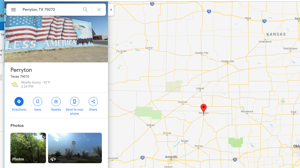
There's a 40-mile loop just west of Perryton that flirts with 5.3'/mile.

Shrug. You eventually get to the top of a climb. You can ride all day and never get to the top of a headwind.
There's a 40-mile loop just west of Perryton that flirts with 5.3'/mile.
Shrug. You eventually get to the top of a climb. You can ride all day and never get to the top of a headwind.
Likes For tcs:
06-27-19, 01:32 PM
#35
Senior Member
06-27-19, 01:33 PM
#36
meh
Thread Starter

Join Date: Jul 2014
Location: Hopkins, MN
Posts: 4,726
Bikes: 23 Cutthroat, 21 CoMotion Java; 21 Bianchi Infinito; 15 Surly Pugsley; 11 Globe Daily; 09 Kona Dew Drop; 96 Mondonico
Liked 1,070 Times
in
532 Posts
Also, I had to look up Perryton and got a laugh at the image on Google - "LESS AMERICA" ... what kinda godless commie town is this?!?!

Likes For Hypno Toad:
06-27-19, 02:25 PM
#37

Senior Member

Join Date: Feb 2004
Location: St Peters, Missouri
Posts: 30,225
Bikes: Catrike 559 I own some others but they don't get ridden very much.
Liked 645 Times
in
366 Posts
The longest "flat" ride I can think of in Colorado is the 40 to 50 miles from Aspen to Glenwood Springs. It's right in the middle of the mountains but it only drops 462 feet over 41 miles (11feet/mile). Of course if you get off the trail to go anywhere else, things go south quickly.
Denver has the Platte River Trail which drops 700 feet in 37 miles (19 feet/mile) and the Cherry Creek Trail which is 700 feet in 27 miles (26 feet/mile). Again, any rides away from those trails get steep fast.
For true dead flatness, the Highline Canal Trail is a good bet. 50 miles, 530 feet or about 10 feet per mile.
__________________
My greatest fear is all of my kids standing around my coffin and talking about "how sensible" dad was.
My greatest fear is all of my kids standing around my coffin and talking about "how sensible" dad was.
06-27-19, 02:59 PM
#38
meh
Thread Starter
Join Date: Jul 2014
Location: Hopkins, MN
Posts: 4,726
Bikes: 23 Cutthroat, 21 CoMotion Java; 21 Bianchi Infinito; 15 Surly Pugsley; 11 Globe Daily; 09 Kona Dew Drop; 96 Mondonico
Liked 1,070 Times
in
532 Posts
I used Strava to map out a 100-mile route from Howell Island heading West on the Katy Trail - 506 ft of climbing. And that's going 'up'. Dang!!
06-27-19, 03:18 PM
#39
- Soli Deo Gloria -
Join Date: Aug 2015
Location: Northwest Georgia
Posts: 14,779
Bikes: 2018 Rodriguez Custom Fixed Gear, 2017 Niner RLT 9 RDO, 2015 Bianchi Pista, 2002 Fuji Robaix
Liked 738 Times
in
469 Posts
Northwest Georgia has little anyone would call flat apart from the Silver Comet Trail.
It is a converted rail trail and people who lay railroad tracks tend to avoid steep grades.
Even so, it is something like 2300 ft over ~68 miles from the edge of Atlanta to the Alabama border.
There are several trestles, one long tunnel through a mountain and many rock cuts which make it much flatter than the surrounding terrain.
-Tim-
06-27-19, 03:31 PM
#40
Senior Member
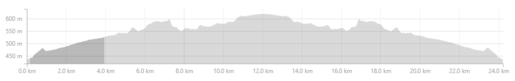
This was my route yesterday on my FG. So flat Google maps doesn't even show elevation.
It's my favorite place to ride on a Sunday because you can choose to go flat flat or throw in great hill climbs on either end up and down those green mountains.

Vedder Canal

Tobacco drying sheds

This was the hilly part

It's my favorite place to ride on a Sunday because you can choose to go flat flat or throw in great hill climbs on either end up and down those green mountains.
Vedder Canal
Tobacco drying sheds
This was the hilly part
Last edited by Happy Feet; 06-27-19 at 03:39 PM.
06-27-19, 04:09 PM
#41
1/2 as far in 2x the time
Join Date: Nov 2013
Location: Northern Bergen County, NJ
Posts: 1,746
Bikes: Yes, Please.
Liked 286 Times
in
222 Posts
Depends how you read the data....

Doing any kind of lap route in Inland SoCal is gonna be 35ft/mi or more. That's just how it is. I live at ~1,300ft, and two subdivsions over (about 3 miles) it's 1,800ft. I can climb 3,000ft simply by riding 15 miles east.
Sooo... six laps around the old AFB now non-operational airport, bolstered by about twenty half-mile laps around Parking Lot C, just in front of the airport terminal. This is SoCal. 20ft/mi is as flat as it gets unless you go to the beach.
Even just riding beside the Santa Ana River for 20 miles picks up about 10ft/mi when going "downhill," and another 700ft or so on the return trip.
If it were one-way, I've found a route that can take me 70 miles from my house to the Pacific Ocean with barely 800ft of climbing. But the return trip is like 2,500ft.
I ride around that old AFB a lot. Closest thing we have to flat. And at that, the east end of the runway is 70ft higher than the west end.

 statistics are funny things. For a hundred miles solo, I think you have reason to be pleased.
Cheers, Eric
06-27-19, 05:13 PM
#42

My first century, actually a double, was in 1971. The Wolverine Sports Club puts on an annual double century on Belle Isle, an island park in the Detroit River with a five mile perimeter, so the 24 hour double century is 40 laps. It�s totally flat and you are obviously always in the company of lots of other cyclists.
As I recall, at that time at least, it was the only time camping was allowed on the island so it was a festive affair. My roommate and I decided to do it, with no training, and me on my Schwinn Suburban and he on his Varsity.
As I recall, at that time at least, it was the only time camping was allowed on the island so it was a festive affair. My roommate and I decided to do it, with no training, and me on my Schwinn Suburban and he on his Varsity.
06-27-19, 09:09 PM
#43
Palmer
Join Date: Mar 2007
Location: Parts Unknown
Posts: 8,781
Bikes: Mike Melton custom, Alex Moulton AM, Dahon Curl
Liked 1,975 Times
in
1,135 Posts
06-27-19, 09:42 PM
#44
Junior Member
My flattest, an easy ride with a malfunctioning HRM. I do have a bunch of rides at under 10' per mile, including a century at 9' a mile. Not too hard around here...

06-27-19, 09:55 PM
#45
Cycleway town

I don't need a flat route, i have a regen assist system. But if i did, i have an extremely flat 50 mile route.
I live about the same level as The Grand Union Canal. It passes through my town. I should be able to find a flat route to it. There are very few locks on it for the first 25 miles north (three i think) where the level drops just a few feet.
So that's a 50 mile round trip within a 20ft layer, with very occasional variation.
Wouldn't wanna do it with 23mm tyresm though. For that, it'd have to be the UK's first road, the 1,930 year old Watling Street, which also passes through my town. Here it runs along side the high-speed London to Birmingham main railway line. That's pretty flat.
If i wanted really flat i'd go to East Anglia, where an entire corner of England is like the salt flats, but green.
06-28-19, 12:13 AM
#46
Senior Member

https://www.strava.com/activities/156952670/overview
https://www.strava.com/activities/156952670/analysis
Looking at it, it is pretty flat from about Marthasville to Columbia (Rocheport/New Franklin/Boonville Bridge).
https://www.strava.com/routes/19875341
RT, one gets 228.32 miles.
1116 ft.
4.89 feet per mile.
Of course one gets a little extra rolling resistance from the limestone gravel surface.
Likes For CliffordK:
06-28-19, 05:01 AM
#47
In Real Life

Join Date: Jan 2003
Location: Down under down under
Posts: 52,151
Bikes: Lots
Liked 601 Times
in
332 Posts
Rowan and I cycled this route on Sunday ... we chose it because it is one of the flatter ones around. If we extend it to 60 km (40 miles), it would be hillier.
The Cycleway is pretty flat and again, if we went further, it would be hillier.
The Pipeline Track is another reasonably flat option.
We could go out to Seven Mile Beach and be able to ride a fairly flat route but there might be some loops etc.
We go to a nearby town and do laps and loops for another reasonably flat ride.
And I think that's the extent of our choices of flat routes. Nothing over about 30 km. If we wanted to do more, we'd have to do the routes more than once.
Sunday -- First ride on a relatively flat southern route since April 2017.  It was challenging because it is one of the longer rides we've done since Rowan's accident and also one of the hillier ones ... despite the relative flatness of the route. However, it was a nice ride in some different scenery.
Chilly day with high of 10C and cooling down to 8C with a "Feels Like" temp of 6C the whole time. A bit overcast and light winds.
Distance: 30.48km
Elevation: 293m
Moving Time: 1:52:46
Elapsed Time: 1:59:54
Speed: Avg: 16.2km/h | Max: 37.8km/h


https://www.flickr.com/photos/machka-bb/
It was challenging because it is one of the longer rides we've done since Rowan's accident and also one of the hillier ones ... despite the relative flatness of the route. However, it was a nice ride in some different scenery. Chilly day with high of 10C and cooling down to 8C with a "Feels Like" temp of 6C the whole time. A bit overcast and light winds.
Distance: 30.48km
Elevation: 293m
Moving Time: 1:52:46
Elapsed Time: 1:59:54
Speed: Avg: 16.2km/h | Max: 37.8km/h
https://www.flickr.com/photos/machka-bb/
The Cycleway is pretty flat and again, if we went further, it would be hillier.
Sunday -- Went cycling again. Was a bit chilly out there ... 12C to start and down to 8C by the end of the ride. That's three days of cycling in a row in the middle of winter!!
Distance: 27.02km
Elevation: 171m
Moving Time: 1:28:01
Elapsed Time: 1:31:12
Speed: Avg: 18.4km/h | Max: 29.9km/h
Distance: 27.02km
Elevation: 171m
Moving Time: 1:28:01
Elapsed Time: 1:31:12
Speed: Avg: 18.4km/h | Max: 29.9km/h
The Pipeline Track is another reasonably flat option.
Saturday -- Rowan and I cycled up the Pipeline Track. It's a trail partway up Mt Wellington. At first there are a few houses around, and then the trail continues into the bush up the mountain. It was lovely!
Now ... his Strava says about 25 km. I don't know why there's such a difference give that we did the same ride. But anyway ...
Distance: 24.22km
Elevation: 382m
Moving Time: 2:17:34
Elapsed Time: 2:38:41
Speed: Avg: 10.6km/h | Max: 22.3km/h
Now ... his Strava says about 25 km. I don't know why there's such a difference give that we did the same ride. But anyway ...
Distance: 24.22km
Elevation: 382m
Moving Time: 2:17:34
Elapsed Time: 2:38:41
Speed: Avg: 10.6km/h | Max: 22.3km/h
We could go out to Seven Mile Beach and be able to ride a fairly flat route but there might be some loops etc.
We go to a nearby town and do laps and loops for another reasonably flat ride.
And I think that's the extent of our choices of flat routes. Nothing over about 30 km. If we wanted to do more, we'd have to do the routes more than once.
__________________
Rowan
My fave photo threads on BF
Century A Month Facebook Group
Machka's Website
Photo Gallery
Rowan
My fave photo threads on BF
Century A Month Facebook Group
Machka's Website
Photo Gallery
Last edited by Machka; 06-28-19 at 05:12 AM.
Likes For Machka:
06-28-19, 04:45 PM
#48
Senior Member

Join Date: Dec 2007
Location: Central Illinois
Posts: 870
Bikes: 2008 Dawes Haymaker 20XX Leader LD515 TotoCycling Road Bike
Likes: 0
Liked 32 Times
in
19 Posts
I have to ride pretty far to see any kind of real elevation gain in Central Illinois. Most of it is flat as a pancake until you get to a river.
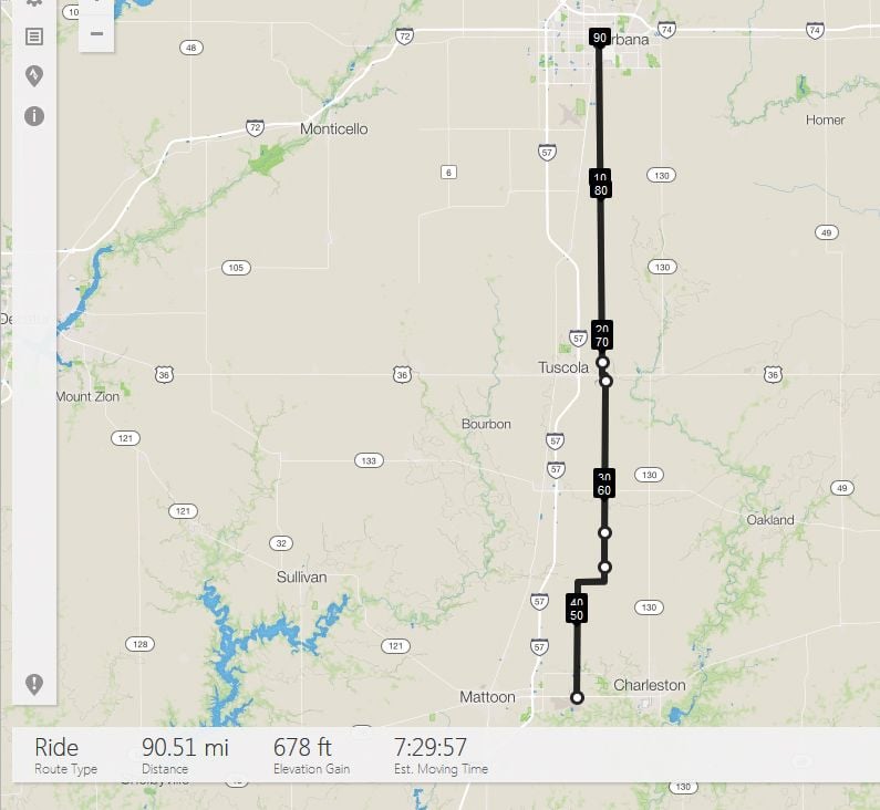
And this is the scenery you get to look at for all 90 miles of it [round trip].

And this is the scenery you get to look at for all 90 miles of it [round trip].
06-28-19, 05:46 PM
#49
Senior Member
I think of something as "flat" if it's the kind of course I'd seek out to do a fast, steady tempo speed. The flattest out-and-back course for more than 10 miles (it's 12.2 miles) that I can make starting in Ithaca, NY is +/- 27.1 feet per mile (it has a few rollers with above 6% maximum grades) and the flattest loop that I've created that's longer than 10 miles (it's 16.53 miles) is +/- 25.2 feet per mile, but it's got a couple of short back-to-back rollers with 10.2% and 8.4% maximum grades and almost all of the elevation change occurs within two stretches of 5 miles and 3 miles (plus the road surface is sub-par to ridiculously awful for about 4 miles). So nothing in town is what I'd call conducive to fast, steady riding for the whole thing. You can make short loops that are flatter (mostly downtown) but they have way too many sharp turns and potential stops to be good for a decent-speed tempo ride.
I have to go about 17 miles from my place to get to it, but riding on this road boosts the speed by a little over a mile per hour vs. the courses that start and finish in Ithaca:
www.strava.com/activities/1835528102
Strava says the elevation gain is 15.8 feet per mile and the road is only mildly bad in a few half-mile-long spots. I went out and back twice on that recorded bit and stopped short of where I started on the second return (needed to get to a C-store for a water refill or I would have had to go 21 more miles to the next store), so it was basically 23.7 miles for the first out-and-back on that ride. You can go a few miles farther SSE toward Owego than I did and still stay just as flat, so that means you can get 30+ miles on one out-and-back. You can't get 40 miles without at least two U-turns or without encountering a grade above 6%, but it's the best you can get around here if you want to stay on flat terrain or very shallow slopes. The regular state TT course is a little farther South of this road and is just about as flat, with an elevation gain of 16.8 feet per mile. It's pretty fast.
Last edited by Zuzus pedals; 06-28-19 at 07:59 PM.
06-28-19, 06:11 PM
#50
Senior Member
Does this count?
https://www.strava.com/activities/718263879
It does list some climbing, I think with some rolling hills near the start of the ride...
70 miles (just over metric century), and 6,616 feet elevation drop.
It lists climbing at about 2,976 feet, but add that in, and one has nearly 10,000 feet of descending.
I'm not quite sure why my speed wasn't higher. I was hitting 40 MPH on some of the descents. Loaded. I also had a radial tire wire in one of my tires causing slow leaks and pinch flats, and being hard to locate.