


Paper maps? What do you use?
 10-24-19, 09:10 PM
#1
Senior Member
Thread Starter
Join Date: Apr 2013
Posts: 1,173
Bikes: Surly Disk Trucker, 2014 w/Brooks Flyer Special saddle, Tubus racks - Duo front/Logo Evo rear, 2019 Dahon Mariner D8, Both bikes share Ortlieb Packer Plus series panniers, Garmin Edge 1000
Mentioned: 2 Post(s)
Tagged: 0 Thread(s)
Quoted: 405 Post(s)
Liked 115 Times
in
99 Posts
Paper maps? What do you use?
I got to looking at maps here... I have been over the road in a semi before and use Rand McNally atlases. I keep a large format one with me on my vehicular travels - spiral bound so I can fold the pages back. They have smaller 8.5x11 spiral bound atlases also. However, that would still be too big/bulky for biking.
What maps do you use for your travels? My reference here is North America (namely lower 48 states), not other continents/countries.
Have you found paper maps (flat-folding pieces of paper) that have bike routing (such as rail-trails and municipal bike trails) which are not contained in a glue-bound book format? Maybe spiral bound at least?
I'm pretty sure most rest stops (especially at/close to state borders) have state maps available. I'm thinking those might be the best option for major roads/county highways, but not sure any would show any bicycle-level detail?
 10-24-19, 09:40 PM
#2
Senior Member
Join Date: Feb 2012
Location: Golden, CO and Tucson, AZ
Posts: 2,836
Bikes: 2016 Fuji Tread, 1983 Trek 520
Mentioned: 13 Post(s)
Tagged: 0 Thread(s)
Quoted: 675 Post(s)
Liked 741 Times
in
430 Posts
One of my favorites for shorter trips is the DeLorme state series. I'll cut the pages I need out with a razor blade, and tape them back in after the trip. Would you be willing to slice up your Rand McNally?
AAA road maps are okay, especially if you know someone with a membership. I trim those down to my route. They're probably similar to the large Rand McNally in scale and info.
As far as bike routes, some state highway department websites will at least show road maps with shoulder widths and traffic volumes. I've never printed those, but I use them for planning. Once in a while you'll find a state that has bike routes mapped out, but I seldom find one of those going my way.
I also look at Warmshowers. If there are host houses along a route, it's likely other cyclists go that way. And the hosts may be able to recommend routes.
10-24-19, 11:32 PM
#3
Senior Member
Thread Starter
Join Date: Apr 2013
Posts: 1,173
Bikes: Surly Disk Trucker, 2014 w/Brooks Flyer Special saddle, Tubus racks - Duo front/Logo Evo rear, 2019 Dahon Mariner D8, Both bikes share Ortlieb Packer Plus series panniers, Garmin Edge 1000
Mentioned: 2 Post(s)
Tagged: 0 Thread(s)
Quoted: 405 Post(s)
Liked 115 Times
in
99 Posts
I wouldn't cut up any of my atlases.
However, Rand McNally does have a ~ 8x11" spiral-bound atlas:
https://store.randmcnally.com/rand-m...oad-atlas.html
It would be possible to unscrew the binding to get the loose pages.
When I mentioned "bike routing" in my first post I meant bike trails, not posted/marked/proper signage "bike routes" with the little green street signs. However, that would be really good to have. I went through a town on a trip a few days ago that had a marked bike route. I was on it for a short bit.
I can't say that I have seen any maps that show those posted bike routes before. That would be good information, though, if it is marked on maps.
I did open up my large scale atlas here just now to see what it shows. It is a motor-carrier specific atlas so it is tuned to trucking. It primarily has the national network of truck-approved routes (that usually narrows down to just state routes, secondary routes/county roads in some cases, also, but each state has different regs once you get off truck routes and the atlas shows very few of those in-between roads). So needless to say, it has nothing mentioning biking. The base/background map, however, does outline parks, national forests, etc, along with some touristy type waypoints, but I have a suspicion all of their atlases have that info (shared base map with the road level detail that changes).
10-25-19, 12:27 AM
#4
☢
I haven't used paper road maps since I was a kid but I would used trail maps (guide pamphlets) when cycling.
 10-25-19, 04:42 AM
#6
Senior Member
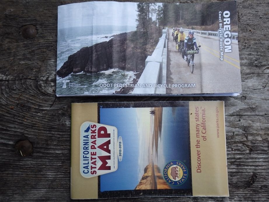
Some states have nice bike maps. Oregon comes to mind, but there are others. Quite a few states offer something. Quality and completeness may vary. Most offer them for free if you contact their DOT or tourism people.
Also there are also maps for specific bike routes. Some are from states. Again Oregon's Pacific Coast route is an example, but there are probably others. Adventure Cycling offers many others. These are all great if you want a map for a specific route.
The Delorme Atlas & Gazetteer series are super detailed, but are big books and awkward to carry unless cut up or copied and pieces carried. I don't tour with them, but they are the best maps I have seen for someone who wants detailed maps that show smaller roads and bike paths. The drawback is that they don't stay in date like electronic maps. I guess that is true of all paper maps with the exception of maybe Adventure Cycling maps where you have the latest updates available in text form as long as you bother to download the addenda.
Personally I am not too into rail-trails, municipal bike trails, and all that and usually am looking for routes on either state/county roads or US highways so the regular state maps that states give away for free are usually fine for my use. I actually like to keep it super simple and follow highways with a US designation like US90 or US101 a lot of the time so I might cross a couple states without really needing to look at a map. Still having a paper map in sight to glance at to monitor progress is nice.
I use paper for gross navigation between towns. Detailed navigation these days, for me is mostly in town and increasingly I use my phone for that.
10-25-19, 05:06 AM
#7
Senior Member
Join Date: Aug 2010
Location: Madison, WI
Posts: 11,199
Bikes: 1961 Ideor, 1966 Perfekt 3 Speed AB Hub, 1994 Bridgestone MB-6, 2006 Airnimal Joey, 2009 Thorn Sherpa, 2013 Thorn Nomad MkII, 2015 VO Pass Hunter, 2017 Lynskey Backroad, 2017 Raleigh Gran Prix, 1980s Bianchi Mixte on a trainer. Others are now gone.
Mentioned: 48 Post(s)
Tagged: 0 Thread(s)
Quoted: 3459 Post(s)
Liked 1,465 Times
in
1,143 Posts
Depends on where I am going. At the state level, usually a state published map.
As mentioned above by staehpj1, Oregon has a great map for Pacific Coast. I could not find a good California equivalent, but while riding the California coast I used a state map of state parks. I was there in 2014, they likely have updated maps since then.
The popular rail trails often have a map or guildebook, or maybe both.
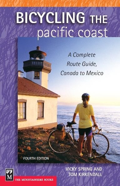
And some routes like the Pacific Coast for example have their own guidebook too, I got my copy for my 2014 trip on Amazon.
As mentioned above by staehpj1, Oregon has a great map for Pacific Coast. I could not find a good California equivalent, but while riding the California coast I used a state map of state parks. I was there in 2014, they likely have updated maps since then.
The popular rail trails often have a map or guildebook, or maybe both.
And some routes like the Pacific Coast for example have their own guidebook too, I got my copy for my 2014 trip on Amazon.
10-25-19, 05:45 AM
#8
bicycle tourist
Depends a bit where I go...
For most Western States, outside urban areas, state-level paper maps are a reasonable choice (1). Entering the most urban areas, I'll let the paper map give me the overview and use other sources e.g. online maps, Strava heat map give me additional details (2).
In places where I do some more detail, I'll typically have done some more research in advance with a map like the delorme series and carry along a photocopy of relevant pages (3).
More specific examples of each of each of these:
(1) crossing West Texas where state map is fine
(2) entering/leaving a larger city like Houston or San Antonio
(3) cycling the remote gravel road along the Rio Grande between Laredo and Eagle Pass.
10-25-19, 05:53 AM
#9
Senior Member
Join Date: Jan 2010
Posts: 39,231
Mentioned: 211 Post(s)
Tagged: 1 Thread(s)
Quoted: 18409 Post(s)
Liked 15,522 Times
in
7,325 Posts
I don't wander. I map my routes with RWGPS and then make cue sheets for each day. I may take along a state map in the event a detour is necessary.
10-25-19, 07:02 AM
#10
Senior Member
caretaker, family myth has it that my great grandfather toodled all around the Worthing area on a pennyfarthing, which I always found pretty neat. I like to think I'm carrying on his tradition, and my over 50 year old memories of the friendly, skinny old fellow in his 90s are nice ones.
He may have used these maps.
He may have used these maps.
10-25-19, 07:06 AM
#11
Senior Member
KC, I too have used a few State produced maps promoting cycling, Vermont is probably the best example, as it shows recommended roads for biking etc.
In the past, I've just used whatever maps I could scrounge up, but large scale stuff that doesnt show much detail is always going to so so, but depends on the locale.
I know the Vermont one is easily found online, so probably looking into specific states for similar maps could be done online to see if they exist.
there is still something about a real paper map that I like having with me always, despite poo pooing by the gps only crowd. Maps and gps stuff are a great combo.
10-25-19, 07:57 AM
#12
Senior Member

Join Date: May 2008
Posts: 7,384
Mentioned: 49 Post(s)
Tagged: 0 Thread(s)
Quoted: 800 Post(s)
Liked 218 Times
in
171 Posts
Paper maps? What do you use
I have posted about my use of paper maps in my decades-long cycling lifestyle:
.
I got to looking at maps here... I have been over the road in a semi before and use Rand McNally atlases�.
What maps do you use for your travels? My reference here is North America (namely lower 48 states), not other continents/countries.
Have you found paper maps (flat-folding pieces of paper) that have bike routing (such as rail-trails and municipal bike trails) which are not contained in a glue-bound book format? Maybe spiral bound at least?
I'm pretty sure most rest stops (especially at/close to state borders) have state maps available. I'm thinking those might be the best option for major roads/county highways, but not sure any would show any bicycle-level detail?
...On our tours, including a cross-country ride in 1977, we have had a similar strategy of 50 miles per day (or more to reach a shower). On that ride we used a large paper map of the USA to plot our general route [and individual state maps to cross the state]. We left Los Angeles on May 4,and had to be in Boston by July 1.
In California we were strongly advised to avoid Las Vegas, so we went through Arizona. After crossing the Rockies we realized we were not making enough progress, so we veered towards Washington DC, and arrived on June 27 with enough time for sight-seeing, and then took the train with our bikes to Boston...
In California we were strongly advised to avoid Las Vegas, so we went through Arizona. After crossing the Rockies we realized we were not making enough progress, so we veered towards Washington DC, and arrived on June 27 with enough time for sight-seeing, and then took the train with our bikes to Boston...
�My favorite map for the Metro Boston area [and other cities] is the AAA Metropolitan Boston map. It covers a wide area, including west beyond Concord and south to Blackstone and the Rhode Island border. The scale is small enough to show many excellent cycling backroads, as thin gray or black routes.
As you may not already know [posting from Michigan], Metro Boston has very confusing, seemingly haphazard roads. Many streets, particularly the one you are riding on are not marked; they surreptiously change names; and in rotatry intersections it's easy to lose your sense of direction.
So I supplement the paper map with my I-phone, at least to identify where I am on the map.
10-25-19, 04:43 PM
#13
Full Member
Join Date: Feb 2015
Location: Pittsburgh, PA
Posts: 400
Bikes: Schwinn, Nishiki, Santana, Trek, Rodriguez
Mentioned: 0 Post(s)
Tagged: 0 Thread(s)
Quoted: 189 Post(s)
Likes: 0
Liked 106 Times
in
69 Posts
Love paper maps, they give you a perspective that is not convenient with e-stuff. Delorme atlases (and others) are not that expensive and a great scale for month long bike tours. Perhaps it is heresy to put a knife to 'em, but after you have done it once, you will feel no compunction in the future. Write notes, mark routes, highlight campgrounds, groceries, etc., ... a nice planning task during winter. A couple maps then fit nicely into an ortlieb map case on your handlebar bag.
Likes For IPassGas:
10-25-19, 07:44 PM
#14
Senior Member

Join Date: Jan 2016
Location: 961' 42.28� N, 83.78� W (A2)
Posts: 2,344
Bikes: Mongoose Selous, Trek DS
Mentioned: 8 Post(s)
Tagged: 0 Thread(s)
Quoted: 941 Post(s)
Liked 319 Times
in
189 Posts
Love paper maps, they give you a perspective that is not convenient with e-stuff. Delorme atlases (and others) are not that expensive and a great scale for month long bike tours. Perhaps it is heresy to put a knife to 'em, but after you have done it once, you will feel no compunction in the future. Write notes, mark routes, highlight campgrounds, groceries, etc., ... a nice planning task during winter. A couple maps then fit nicely into an ortlieb map case on your handlebar bag.
10-25-19, 09:08 PM
#15
Senior Member
Delorme, I copy the pages I need for each trip. While phones are great, they usually don't show contours or streams and such. Also they give a much bigger picture of the day. And don't need cell service or a battery.
10-28-19, 09:58 AM
#16
Newbie
I use AAA maps for US/Canada touring; they are small and lightweight and often contain 2 states on one map, one on each side. I carry a map of the entire US as well, for overall referencing, to ensure I'm not veering too far off whatever direction I'm headed. I enjoy highlighting my route as I go, and once clear of a state I mail it home. At the end of my tour (mine are usually 3 or 4 months) I have a nice bundle to keep as a souvenir, topped by the US map showing the whole trip. My membership is $35 a year, includes unlimited maps, and now offers towing for bicycles. If I don't want to carry a whole summer's worth of maps I visit a AAA location along the way. Google maps fills in the details (supermarkets, motels etc). I find the free maps from many states to be of lesser quality, bulkier and full of advertising.
11-01-19, 09:18 PM
#17
Word.
Join Date: Jul 2008
Location: Rural New England
Posts: 232
Bikes: Surly Disc Trucker, Orbea Oiz XCountry Bike, Specialized Roubaix, Borealis Echo Fat Bike for Winter, many others out in the barn.
Mentioned: 0 Post(s)
Tagged: 0 Thread(s)
Quoted: 64 Post(s)
Liked 99 Times
in
51 Posts
I buy DeLorme Atlas and Gazetteers and cut the pages out with a razor blade. I number them in the order I need them and put them 3 pages at a time in the map case on my handlebar bag. So much better than any electronic device IME.
I avoid cycling maps, because I avoid other cyclists.
I avoid cycling maps, because I avoid other cyclists.
11-01-19, 10:16 PM
#18

just another gosling
Join Date: Feb 2007
Location: Everett, WA
Posts: 19,528
Bikes: CoMo Speedster 2003, Trek 5200, CAAD 9, Fred 2004
Mentioned: 115 Post(s)
Tagged: 0 Thread(s)
Quoted: 3886 Post(s)
Liked 1,938 Times
in
1,383 Posts
I haven't used paper maps since . . . well, I don't remember when. Long time ago, anyway. I plan my routes on RidewithGPS, put the route(s) on my Garmin and also print out cue sheets. If I think I might need to change routes during the tour, I'd take an iPad or Surface to modify or create routes.
__________________
Results matter
Results matter
11-03-19, 04:44 AM
#19
Senior Member
I kind of thought the same way, but after thinking about it a bit...
You can find the DeLorme Atlas & Gazetteers new for $12-15 and used for as little as $3-4 per state. If on a longish tour where you are spending much time in each state that really isn't much of an expense. You could buy an extra one just to cut up.
You could carry a limited number of pages or partial pages either folded up or rolled and in a tube. I don't like to carry much paper, but you could carry as many or as few pages as you see fit. If you don't butcher them too badly you could use them on multiple trips, but otherwise you could just write off the cost as an expense of the trip. For a short trip or even a long one where you are only in a given state a short while that may be pretty spendy, but otherwise it may not be too bad.
11-04-19, 10:18 AM
#20
Word.
Join Date: Jul 2008
Location: Rural New England
Posts: 232
Bikes: Surly Disc Trucker, Orbea Oiz XCountry Bike, Specialized Roubaix, Borealis Echo Fat Bike for Winter, many others out in the barn.
Mentioned: 0 Post(s)
Tagged: 0 Thread(s)
Quoted: 64 Post(s)
Liked 99 Times
in
51 Posts
Also, since I live in Massachusetts and tour out west, I don't hesitate to cut the pages out, because I don't see ever using them in a way that requires the books to stay in tact.
11-04-19, 03:04 PM
#21
Senior Member
Thread Starter
Join Date: Apr 2013
Posts: 1,173
Bikes: Surly Disk Trucker, 2014 w/Brooks Flyer Special saddle, Tubus racks - Duo front/Logo Evo rear, 2019 Dahon Mariner D8, Both bikes share Ortlieb Packer Plus series panniers, Garmin Edge 1000
Mentioned: 2 Post(s)
Tagged: 0 Thread(s)
Quoted: 405 Post(s)
Liked 115 Times
in
99 Posts
As far as the maps go - I found it interesting this summer that there was a new portion of Rt 53 through Minnesota that, to the best of my knowledge, was not passable in 2017 until some time in 2018 (haven't researched it in depth yet), that was listed in my 2018 Rand McNally atlas as the "new" route. What is interesting about it is if, at the time of publication, the road was the "old" route, how was it that the printed atlas could have the "new" route on it? If they went off of a proclaimed schedule of completion - who's to say a delay wouldn't show up? Then if the road was the "old" route in 2018 and the atlas showed the "new" route it would be incorrect.
I would think the dating of atlases might work better backwards than forwards. For example - how often is it that routes disappear vs new routes and bypasses being created? If you stick to an old route through a town - which you would do on a bicycle anyway - and there is a bypass route/4 lane freeway built around town (look at Burlington, WI for example) - who cares if a map/atlas doesn't show the new route? Now, if the old route through town disappeared (not likely) then that would be an issue to a cyclist.
11-05-19, 04:46 AM
#22
Senior Member
I've run a semi over-the-road before and one thing that is, in my opinion, critical is to have as up-to-date of an atlas as possible. On the trucking side of the fence - it is beyond the map accuracy because there are state regulations and contact info for local and state authorities in there, so those can be as important if TSHTF as knowing where the roads are (and I have had to use the "other" resources before, not that I want to but the point is having them when you need them is a blessing).
As far as the maps go - I found it interesting this summer that there was a new portion of Rt 53 through Minnesota that, to the best of my knowledge, was not passable in 2017 until some time in 2018 (haven't researched it in depth yet), that was listed in my 2018 Rand McNally atlas as the "new" route. What is interesting about it is if, at the time of publication, the road was the "old" route, how was it that the printed atlas could have the "new" route on it? If they went off of a proclaimed schedule of completion - who's to say a delay wouldn't show up? Then if the road was the "old" route in 2018 and the atlas showed the "new" route it would be incorrect.
I would think the dating of atlases might work better backwards than forwards. For example - how often is it that routes disappear vs new routes and bypasses being created? If you stick to an old route through a town - which you would do on a bicycle anyway - and there is a bypass route/4 lane freeway built around town (look at Burlington, WI for example) - who cares if a map/atlas doesn't show the new route? Now, if the old route through town disappeared (not likely) then that would be an issue to a cyclist.
I only brought up the used maps because someone just might:
1. Find a deal on some that are fairly new. Sometimes people buy new ones for one trip and sell them. You might just get lucky if you look.
2. Be on a super tight budget and/or only need to be in a state for a short bit and be willing to take the chance with an old Gazetteer.
3. Be willing to use new free state maps or a phone app with google maps and supplement some of the details with an old Delorme Gazetteer.
11-05-19, 07:55 AM
#23
Senior Member
Thread Starter
Join Date: Apr 2013
Posts: 1,173
Bikes: Surly Disk Trucker, 2014 w/Brooks Flyer Special saddle, Tubus racks - Duo front/Logo Evo rear, 2019 Dahon Mariner D8, Both bikes share Ortlieb Packer Plus series panniers, Garmin Edge 1000
Mentioned: 2 Post(s)
Tagged: 0 Thread(s)
Quoted: 405 Post(s)
Liked 115 Times
in
99 Posts
On a day tour this spring near Everett, PA I ran in to an impassable road - after having climbed a couple hundred feet in to the PA hill country. It was a road closure due to a family feud over land access between 2 families, as I was told by a local trying to figure out how to get where I was going. Though, in that area there seemed to be an awful lot of private roads also. I got directions to a road that would get me where I wanted to go, but it was interesting along the route seeing signs for "do not enter" and "no trespassing" on, what were on the map, as "roads".
OK on the theories of the old atlases/maps.
OK on the theories of the old atlases/maps.
11-05-19, 08:31 AM
#24
Senior Member
Just to clarify a bit more... I figured from the start that buying used Gazetteers is most often a bad idea. New ones are not expensive enough that I particularly recommend bothering with the used ones. I can see where someone might find them a worthwhile option though. Hence the mention.
Personally I have never used new or used Gazetteers on a tour. I have used them a lot for driving back roads in my whitewater kayaking days. They have been handy for backpacking, XC skiing, and mountain biking, but I have mostly used them to find access points, not so much for riding or hiking. Back in the day they were a wonderful option when not many options were available other than road maps and topos, but I have not actually used gazetteers in years. OTOH, I was recently gifted a new one for my home state so who knows maybe I will use it...
Personally I have never used new or used Gazetteers on a tour. I have used them a lot for driving back roads in my whitewater kayaking days. They have been handy for backpacking, XC skiing, and mountain biking, but I have mostly used them to find access points, not so much for riding or hiking. Back in the day they were a wonderful option when not many options were available other than road maps and topos, but I have not actually used gazetteers in years. OTOH, I was recently gifted a new one for my home state so who knows maybe I will use it...
