


C&O Canal Towpath Conditions at Mile 51 - Brunswich/Little Catoctin Creek
 09-04-18, 04:26 AM
#1
Senior Member
Thread Starter
C&O Canal Towpath Conditions at Mile 51 - Brunswich/Little Catoctin Creek
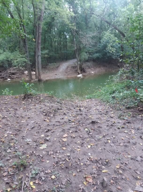
The C&O Canal Towpath is still officially closed between the Brunswick Campground (mile 54 or so) and Lander Lock (mile 51.5) Yesterday, a friend and I hiked from Brunswick and went around the "Trail Closed" sign at the campground. In about a mile you reach the collapsed bridge that carried the towpath across Little Catoctin Creek - it is definitely still out.
However, enterprising hikers and bikers have created a path down to the creek and to a relatively broad shallow area with lots of large rocks. You can get across - saw a cyclist with a loaded bike do it. You will definitely get your feet wet and the path on each side of the creek is muddy and slippery, even under dry conditions. So, not an easy crossing but do-able.
Others seem to use the railroad tracks to get around the outage but those are very active tracks.

Looking east/downstream, Towpath outage at mile 53.
However, enterprising hikers and bikers have created a path down to the creek and to a relatively broad shallow area with lots of large rocks. You can get across - saw a cyclist with a loaded bike do it. You will definitely get your feet wet and the path on each side of the creek is muddy and slippery, even under dry conditions. So, not an easy crossing but do-able.
Others seem to use the railroad tracks to get around the outage but those are very active tracks.
Looking east/downstream, Towpath outage at mile 53.
 09-12-18, 04:58 AM
#2
Senior Member
This is what I hate about trails. Some love it. I have an aversion to mud.
It also looks like lazy asses are throwing trash around.
It also looks like lazy asses are throwing trash around.
09-12-18, 07:05 AM
#3
Senior Member
Join Date: Jun 2008
Location: Shawnee, KS
Posts: 273
Bikes: Bike Friday NWT, Rans Stratus, Cannondale R500, trek 720 multitrack, Rockhopper
Mentioned: 2 Post(s)
Tagged: 0 Thread(s)
Quoted: 35 Post(s)
Liked 36 Times
in
22 Posts
Don’t see any visible effort to repair it either. This was washed out in early June. We were on the trail when the storm hit and cut out trip short because of the wash out.
Allen
Allen
09-13-18, 05:42 AM
#4
Senior Member
Thread Starter
When I took that picture (about 10 days ago) there was a work site about 100 feet from the creek. There was a big Bobcat front loader, a lot of big plastic drainage pipe, a gravel parking pad had been created, etc. They are going to put in a temporary "low water bridge" with planned completion by the end of September.
However, the recent rains have flooded many, many spots along the Potomac (and brought huge boulders down on the GAP Trail in Somerset!) - and now the remnants of Hurricane Florence will be dumping rain early next week. I'm sure there will be delays, but they have gotten started. Latest pre-FLO estimate of total damage was $14M work on the C&O.
However, the recent rains have flooded many, many spots along the Potomac (and brought huge boulders down on the GAP Trail in Somerset!) - and now the remnants of Hurricane Florence will be dumping rain early next week. I'm sure there will be delays, but they have gotten started. Latest pre-FLO estimate of total damage was $14M work on the C&O.
09-13-18, 08:50 AM
#5
Senior Member
Join Date: Jun 2008
Location: Shawnee, KS
Posts: 273
Bikes: Bike Friday NWT, Rans Stratus, Cannondale R500, trek 720 multitrack, Rockhopper
Mentioned: 2 Post(s)
Tagged: 0 Thread(s)
Quoted: 35 Post(s)
Liked 36 Times
in
22 Posts
When I took that picture (about 10 days ago) there was a work site about 100 feet from the creek. There was a big Bobcat front loader, a lot of big plastic drainage pipe, a gravel parking pad had been created, etc. They are going to put in a temporary "low water bridge" with planned completion by the end of September.
However, the recent rains have flooded many, many spots along the Potomac (and brought huge boulders down on the GAP Trail in Somerset!) - and now the remnants of Hurricane Florence will be dumping rain early next week. I'm sure there will be delays, but they have gotten started. Latest pre-FLO estimate of total damage was $14M work on the C&O.
However, the recent rains have flooded many, many spots along the Potomac (and brought huge boulders down on the GAP Trail in Somerset!) - and now the remnants of Hurricane Florence will be dumping rain early next week. I'm sure there will be delays, but they have gotten started. Latest pre-FLO estimate of total damage was $14M work on the C&O.
09-22-18, 06:30 PM
#6
Senior Member
Join Date: Mar 2015
Location: Martinsburg WV Area
Posts: 1,704
Bikes: State 4130 Custom, Giant Trance 29
Mentioned: 7 Post(s)
Tagged: 0 Thread(s)
Quoted: 422 Post(s)
Liked 182 Times
in
123 Posts
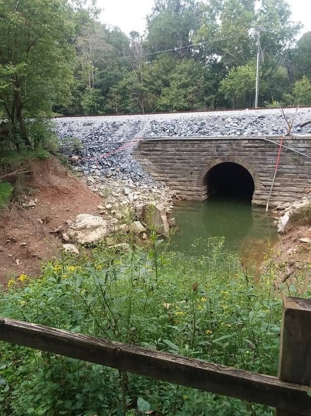
Looks like this is the temporary solution. Unfortunately the creek is high today due to the Potomac being high and flowing fast. Did get to watch one guy walk across this. Water went up to his chest. The railroad looks nicely re stones. But has wiring on it and it is very busy with freight, Amtrak, Marc. Also noticed a rail truck a couple miles down, not sure if they were checking on people crossing here or not.


 09-24-18, 04:02 AM
#8
Senior Member
Thread Starter
Are you sure the temporary solution was actually under there?? There were a lot of rocks there at that spot anyway - without the temporary fix, water probably would have been up to someone's chest at that level!
The temporary fix looked like it was going to be several large black plastic corrugated culvert tubes covered with gravel/ballast - could you actually see those in the stream?
The temporary fix looked like it was going to be several large black plastic corrugated culvert tubes covered with gravel/ballast - could you actually see those in the stream?
09-24-18, 06:21 AM
#9
Senior Member
I don't see them doing much until we get some dry weather if that ever happens again.
09-24-18, 08:46 AM
#10
Senior Member
Join Date: Mar 2015
Location: Martinsburg WV Area
Posts: 1,704
Bikes: State 4130 Custom, Giant Trance 29
Mentioned: 7 Post(s)
Tagged: 0 Thread(s)
Quoted: 422 Post(s)
Liked 182 Times
in
123 Posts
Are you sure the temporary solution was actually under there?? There were a lot of rocks there at that spot anyway - without the temporary fix, water probably would have been up to someone's chest at that level!
The temporary fix looked like it was going to be several large black plastic corrugated culvert tubes covered with gravel/ballast - could you actually see those in the stream?
The temporary fix looked like it was going to be several large black plastic corrugated culvert tubes covered with gravel/ballast - could you actually see those in the stream?
My pictures were really meant to show where the temporary solution will be.
09-25-18, 03:54 AM
#11
Senior Member
Thread Starter
With the near constant rain, I don't think they are going to have the temporary fix in by the end of September! Year to date, looks like Hagerstown area has had about 10" more rain than average, but here in the Baltimore area BWI has had 21" above historical average.
09-29-18, 05:51 AM
#12
Newbie
Join Date: Jun 2017
Location: PA & NY
Posts: 33
Bikes: Specialized Crosstrail, Canyon Endurance AL
Mentioned: 1 Post(s)
Tagged: 0 Thread(s)
Quoted: 13 Post(s)
Likes: 0
Liked 1 Time
in
1 Post
I biked that area July 4th holiday. There are shuttle services that will take you around the closed section, but they can be difficult to book & schedule. One biker I met simply told me he carried his bike up the hill to the railroad tracks and walked the tracks around the closed section.
09-29-18, 07:22 PM
#13
Senior Member
Join Date: Mar 2015
Location: Martinsburg WV Area
Posts: 1,704
Bikes: State 4130 Custom, Giant Trance 29
Mentioned: 7 Post(s)
Tagged: 0 Thread(s)
Quoted: 422 Post(s)
Liked 182 Times
in
123 Posts
I've seen the trains going through, easy enough to hear the freight trains blow the horns a few miles away and the sounds they make. I would be more worried about the Marc and Amtrak trains. Those are very quiet and when you do hear them, they're very close and fast.
11-19-18, 06:34 AM
#14
Senior Member
Thread Starter
Yesterday, a friend and I repeated our Towpath hike from Brunswick out to the site of the culvert washout. As the pictures below show, it is still closed. They seem to have started building the temporary "low bridge" - it is hard to see in the picture, but past that large pile of gravel in the water are several pieces of drainage pipe that were to span the creek and be covered with gravel to let hikers/bikers cross. However, the Potomac River is so high (normally that pile of gravel is on the dry bank) they are probably waiting for the creek to get back to normal levels. There are two backhoes sitting nearby.
At the level the creek is now, the only real way to cross is on the railroad tracks.

The outage - those cyclists are on the downstream side.
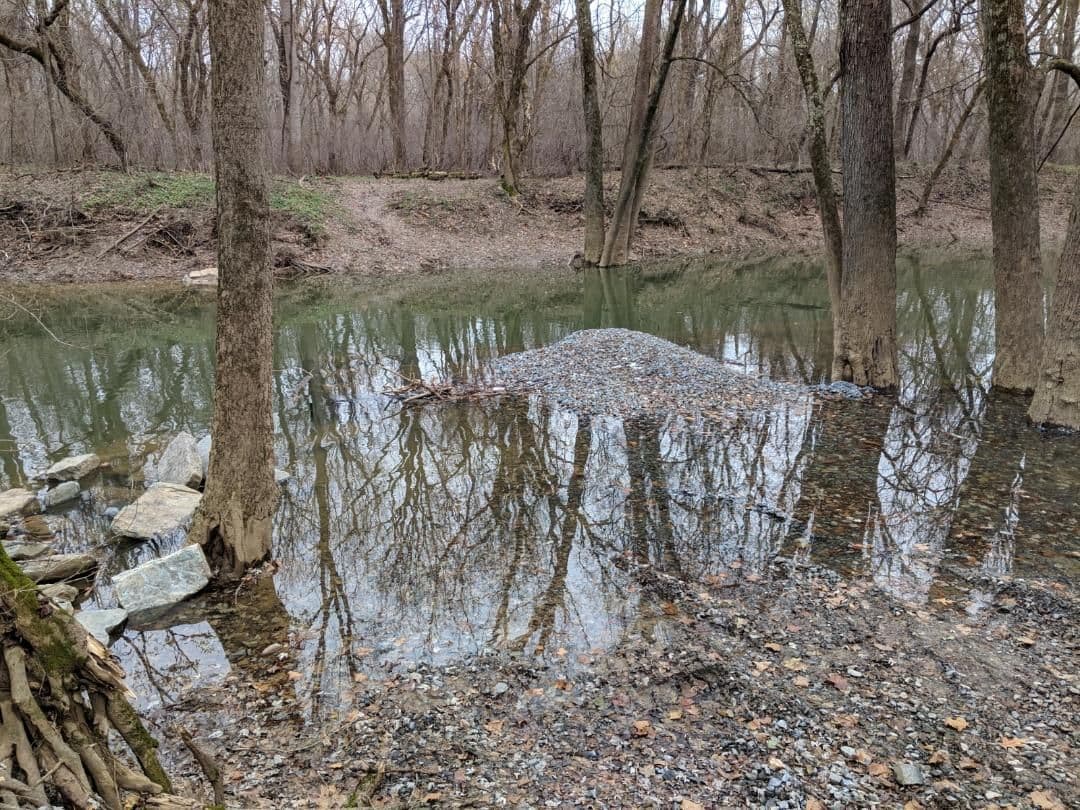
Normally that pile of gravel is on the dry bank, just past it to the left you might be able to see the drainage pipe in the creek that shows they have at least started on the temporary low bridge.
At the level the creek is now, the only real way to cross is on the railroad tracks.
The outage - those cyclists are on the downstream side.
Normally that pile of gravel is on the dry bank, just past it to the left you might be able to see the drainage pipe in the creek that shows they have at least started on the temporary low bridge.

Thread
Thread Starter
Forum
Replies
Last Post
Neil_B
Hosted Travelogs and Stories from the Road
3
09-26-10 08:45 PM
