Portland to Crater Lake bicycling
 03-05-19, 01:12 AM
#1
Junior Member
Thread Starter
Portland to Crater Lake bicycling
I might be visiting Portland in mid-April. I was wondering it would be possible to ride from Portland to Crater Lake and Klamath?
a multi-day ride, for sure... but, am looking for good routes and advice.
I am comfortable with ~100mi/5000ft per day and will possibly pick B&B over tent. and i will not have a car
Thanks in advance,
S
a multi-day ride, for sure... but, am looking for good routes and advice.
I am comfortable with ~100mi/5000ft per day and will possibly pick B&B over tent. and i will not have a car
Thanks in advance,
S
 03-06-19, 02:24 PM
#2
Senior Member


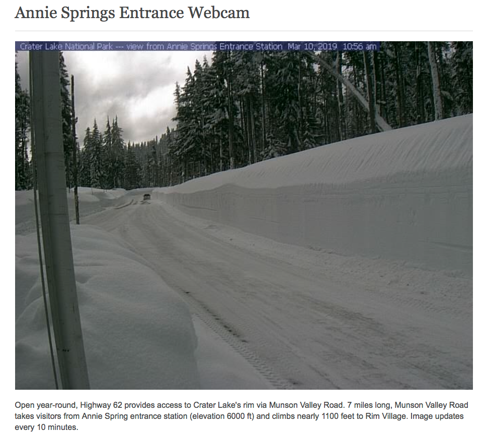
Winter lasts long in the Cascades. The main Rim Road around the lake sometimes doesn't open until June. And Southern Oregon just got walloped with a massive snowstorm. So expecting the snows to melt early is very optimistic.
You can still get to Crater Lake all year. They sort of plow the south entrance, and you can get to the lodge. But the road will probably look like this:
I took this photo around this time last year. Note that they do not plow to pavement.
And you're going to run into the likelihood of hitting snow on any crossing of the Cascades in mid-April.
Better bet for better conditions in mid-April is to stick with the Willamette Valley, or perhaps head east through the Columbia Gorge. The Coast will be mild, but a crapshoot. Could be nice, could be stormy.
03-06-19, 03:52 PM
#3
Junior Member
Thread Starter
i will remember the weather check. I will be visiting often over summer. So, finding the right time should be possible.
My concern is finding a good/friendly/memorable route
My concern is finding a good/friendly/memorable route
03-07-19, 02:36 PM
#4
Newbie
Join Date: Jul 2008
Location: Port Angeles
Posts: 72
Bikes: 2012 Soma Saga, 2020 Black Mountain Cycles MCD, 1992 Univega Alpina Sport
Mentioned: 1 Post(s)
Tagged: 0 Thread(s)
Quoted: 7 Post(s)
Likes: 0
Liked 4 Times
in
3 Posts
How about starting with this: https://tinyurl.com/y3y2vrd4
And then picking up the ACA Sierra Cascades route to Crater Lake.
From there roll around the west side of Klamath Lake to klamath Falls and avoid the truck traffic on 97.
I haven't done it but have been looking at it as a possible trip.
And then picking up the ACA Sierra Cascades route to Crater Lake.
From there roll around the west side of Klamath Lake to klamath Falls and avoid the truck traffic on 97.
I haven't done it but have been looking at it as a possible trip.
03-09-19, 11:09 PM
#5
Banned
ODOT Bike maps https://www.oregon.gov/ODOT/Data/Doc...icycle-Map.pdf
03-10-19, 12:07 AM
#6
Junior Member
Thread Starter
03-10-19, 03:23 AM
#7
Senior Member

Join Date: Nov 2014
Location: Eugene, Oregon, USA
Posts: 27,547
Mentioned: 217 Post(s)
Tagged: 0 Thread(s)
Quoted: 18372 Post(s)
Liked 4,507 Times
in
3,350 Posts
I've done Eugene to Portland, and Eugene to Crater Lake, but not both together.
There is a Seattle to Crater Lake/Klamath Falls Randonneur ride that you might look at. Hmmm, it looks like they go down the coast.
https://ridewithgps.com/routes/2479676
For Portland to Eugene, I usually base my ride on the Willamette Valley Scenic Bikeway, and take a few shortcuts depending on timing.
Here was my basic route from Eugene to Crater Lake. Mmmm... more or less. I did find a good bike path along Dorena Reservoir between Cottage Grove and Culp Creek.
https://www.strava.com/routes/6229282
If you look up "RidetheRim", there are two car free days at the park every fall.
Ride the Rim, September 14 & September 21, 2019
It is a good point about the likelihood of snow at Crater Lake during the spring. A LOT OF SNOW.
We had a relatively heavy late snow here in the valley, and I believe Medford got hit hard. So, that likely means a lot more snow in the mountains.
Crater Lake, OR 97604 Area Snow Depth
So, current conditions are about 126" (just over 10 feet) of snow at the south entrance.
55" at Diamond lake, I think. The Umpqua HWY and similar large highways are probably open, but you may be riding with traffic and snow.
Thanks for the map. It is a good map, but I'm not quite sure what makes it a "Bike Map"
It does appear to be missing several good cycling roads. For example, around here, the North Bank Road along Lookout Point Reservoir is a gravel road, but a better route than HWY 58.
King Road E, and King Road W are good roads along the McKenzie, bypassing some of HWY 126, also not on the map.
There is a Seattle to Crater Lake/Klamath Falls Randonneur ride that you might look at. Hmmm, it looks like they go down the coast.
https://ridewithgps.com/routes/2479676
For Portland to Eugene, I usually base my ride on the Willamette Valley Scenic Bikeway, and take a few shortcuts depending on timing.
Here was my basic route from Eugene to Crater Lake. Mmmm... more or less. I did find a good bike path along Dorena Reservoir between Cottage Grove and Culp Creek.
https://www.strava.com/routes/6229282
If you look up "RidetheRim", there are two car free days at the park every fall.
Ride the Rim, September 14 & September 21, 2019
It is a good point about the likelihood of snow at Crater Lake during the spring. A LOT OF SNOW.
We had a relatively heavy late snow here in the valley, and I believe Medford got hit hard. So, that likely means a lot more snow in the mountains.
Crater Lake, OR 97604 Area Snow Depth
So, current conditions are about 126" (just over 10 feet) of snow at the south entrance.
55" at Diamond lake, I think. The Umpqua HWY and similar large highways are probably open, but you may be riding with traffic and snow.
ODOT Bike maps https://www.oregon.gov/ODOT/Data/Doc...icycle-Map.pdf
It does appear to be missing several good cycling roads. For example, around here, the North Bank Road along Lookout Point Reservoir is a gravel road, but a better route than HWY 58.
King Road E, and King Road W are good roads along the McKenzie, bypassing some of HWY 126, also not on the map.
03-10-19, 11:21 AM
#8
Banned
Bike shops should have a copy in print, We Get them from ODOT District One office
at the foot of the US 101 Megler bridge..
they , ODOT, may mail you one .. OP..
LBS Goes thru a few hundred + of the Coast route maps ... Up Here .. I retrieve a case of them on my bike trailer ..
Join ACA ?
...
at the foot of the US 101 Megler bridge..
they , ODOT, may mail you one .. OP..
LBS Goes thru a few hundred + of the Coast route maps ... Up Here .. I retrieve a case of them on my bike trailer ..
Join ACA ?
...
Last edited by fietsbob; 03-10-19 at 11:27 AM.
03-10-19, 12:03 PM
#9
Senior Member
Join Date: Jul 2011
Location: Salem Oregon
Posts: 1,030
Bikes: 2019 Trek Stash 7, 1994 Specialized Epic 1986 Diamondback Ascent 1996 Klein Pulse Comp, 2006 Specialized Sequoia Elite
Mentioned: 5 Post(s)
Tagged: 0 Thread(s)
Quoted: 418 Post(s)
Liked 521 Times
in
290 Posts
There'll be lots of route choices to ride there once the rim is clear. It probably won't be clear until July or mid-June. The Sierra Cascades route is tough, but scenic. I'd skip the Windigo Pass option. Century Drive is gorgeous. Other roads to consider include adding McKenzie Pass and the Aufderheide.There's a neat backcountry route from Cottage Grove to Steamboat that's pretty neat. Come April I'd stick to the coastal routes and the Willamette Valley. There's still 8 feet of snow up on Santiam Pass. There's lots of nice riding options in April, but also a possibility of multiple days of rain. Have fun!
I don't care for taking Hwy 47 to the coast. I've never ridden Hwy 26. Hwy 6 is alright. The Nestucca River byway is neat. Hwy 18 and 22 are alright. Look into Lobster Valley Road and the Smith River Byway from Reedsport to Veneta. How many miles would you like to ride on your April trip?
Last edited by mtnbud; 03-10-19 at 12:19 PM.

 03-10-19, 12:30 PM
#11
Senior Member
Join Date: Nov 2014
Location: Eugene, Oregon, USA
Posts: 27,547
Mentioned: 217 Post(s)
Tagged: 0 Thread(s)
Quoted: 18372 Post(s)
Liked 4,507 Times
in
3,350 Posts
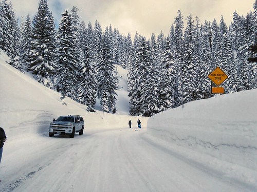
The passes vary by year. It is not uncommon to hit the passes in winter/spring and have mostly dry pavement, then the next year it can be going through a canyon of snow.
This was taken at the McKenzie Pass around February 15 a couple of years ago. I had to hunt for snow.

Normally it should have looked like some of the snow photos above. However, keep in mind that the pass is about 2000 feet lower than the Crater Lake rim road.
Oh, that is another point. The McKenzie pass is usually closed to vehicles until mid June (3rd Monday recently).
It can make a nice bike ride in late May, early June (often chilly on the pass). No cars.
Road condition information is usually sparse, and it makes a better out and back ride than a through ride. You don't want to get stuck having to backtrack after a 20 mile hill climb.
This was taken at the McKenzie Pass around February 15 a couple of years ago. I had to hunt for snow.
Normally it should have looked like some of the snow photos above. However, keep in mind that the pass is about 2000 feet lower than the Crater Lake rim road.
Oh, that is another point. The McKenzie pass is usually closed to vehicles until mid June (3rd Monday recently).
It can make a nice bike ride in late May, early June (often chilly on the pass). No cars.
Road condition information is usually sparse, and it makes a better out and back ride than a through ride. You don't want to get stuck having to backtrack after a 20 mile hill climb.
03-10-19, 12:57 PM
#12
Occam's Rotor
Join Date: Jul 2013
Posts: 7,248
Mentioned: 61 Post(s)
Tagged: 0 Thread(s)
Quoted: 2366 Post(s)
Liked 2,331 Times
in
1,164 Posts