


Total climbed error
 05-30-21, 09:25 PM
#1
Newbie
Thread Starter
Join Date: Apr 2010
Posts: 71
Mentioned: 0 Post(s)
Tagged: 0 Thread(s)
Quoted: 29 Post(s)
Likes: 0
Liked 9 Times
in
7 Posts
Total climbed error
I use a Garmin Fenix 6 Pro for biking. Started a ride at about 2000 ft, rode down to about sea level, rode back to the start. Garmin said the ending altitude was 1100 ft. and total climb only ~1100ft instead of 2000ft.I think its based on barometric pressure
Any one have suggests it avoid future errors?
Any one have suggests it avoid future errors?
 05-30-21, 09:50 PM
#2
Senior Member
Join Date: May 2017
Location: Hacienda Hgts
Posts: 2,109
Bikes: 1999 Schwinn Peloton Ultegra 10, Kestrel RT-1000 Ultegra, Trek Marlin 6 Deore 29'er
Mentioned: 3 Post(s)
Tagged: 0 Thread(s)
Quoted: 822 Post(s)
Liked 1,961 Times
in
944 Posts
Enable the elevation correction feature on Garmin Connect.
Likes For CAT7RDR:
05-31-21, 07:59 AM
#4
Full Member
Join Date: Feb 2019
Location: Connecticut
Posts: 208
Bikes: Cannondale Synapse Carbon 105 (2021) Cannondale Cujo 2 (2018) Cannondale Quick Carbon 1 (2017) Giant Sedona (2006) Cannondale R1000 (2001)
Mentioned: 0 Post(s)
Tagged: 0 Thread(s)
Quoted: 65 Post(s)
Liked 238 Times
in
105 Posts
If it has a barometric altimeter you should be able calibrate it if you know your starting elevation.
I have an Edge Explore that does not have a barometric altimeter. Altitude is calculated by the GPS reference map and is not even close. On a recent ride the Edge showed 2,100 feet, Garmin Connect adjusted it to 2,600 and Strava changed it to 3,100 feet which is accurate.
I have an Edge Explore that does not have a barometric altimeter. Altitude is calculated by the GPS reference map and is not even close. On a recent ride the Edge showed 2,100 feet, Garmin Connect adjusted it to 2,600 and Strava changed it to 3,100 feet which is accurate.
05-31-21, 08:20 AM
#5

I'm good to go!
Join Date: Jul 2017
Location: Mississippi
Posts: 14,992
Bikes: Tarmac Disc Comp Di2 - 2020
Mentioned: 51 Post(s)
Tagged: 0 Thread(s)
Quoted: 6196 Post(s)
Liked 4,811 Times
in
3,319 Posts
If this is just a one time thing then don't dwell on it too much.
If a low pressure area moved out of your area and a high pressure area moved in, then the elevation can be off quit a bit. A tenth of an inch of mercury change in a barometer reading is 100 feet. While I doubt the barometer at your start/end point dropped almost an inch from the time you left till returning, it might play a part in some of the error.
If a low pressure area moved out of your area and a high pressure area moved in, then the elevation can be off quit a bit. A tenth of an inch of mercury change in a barometer reading is 100 feet. While I doubt the barometer at your start/end point dropped almost an inch from the time you left till returning, it might play a part in some of the error.
05-31-21, 10:33 AM
#6
Senior Member

Join Date: Feb 2004
Location: St Peters, Missouri
Posts: 30,225
Bikes: Catrike 559 I own some others but they don't get ridden very much.
Mentioned: 16 Post(s)
Tagged: 0 Thread(s)
Quoted: 1572 Post(s)
Liked 643 Times
in
364 Posts
Since you started and ended in the same place, why shouldn't the elevation gain be zero?
__________________
My greatest fear is all of my kids standing around my coffin and talking about "how sensible" dad was.
My greatest fear is all of my kids standing around my coffin and talking about "how sensible" dad was.
05-31-21, 01:30 PM
#7
Senior Member
Join Date: May 2021
Location: San Francisco
Posts: 2,039
Bikes: addict, aethos, creo, vanmoof, sirrus, public ...
Mentioned: 2 Post(s)
Tagged: 0 Thread(s)
Quoted: 1279 Post(s)
Liked 1,393 Times
in
711 Posts
GPS elevation by itself is terrible, maps and map correction are good in some places not so much in others (e.g. maybe databases seem to think the deck of the golden gate bridge is at sea level, resulting in erroneous 200 foot climbs and falls), and barometric pressure altimeters are potentially the best but subject to weather changes (temperature and pressure!) and calibration issues.
i haven't seen errors as large as described here, but generally modern phones do a pretty good job interpolating and correcting data from multiple sources, including the iPhone's built in barometer, GPS, and other location sensors. my last long ride showed 4,160 in Mission Control, 5,013 based on rideWithGPS on the same device, and 4,607 in strava with strava's map based correction, which I believe to be very close to the actual number looking at the map and corresponding cross section.
05-31-21, 01:57 PM
#8
Senior Member
Join Date: May 2021
Posts: 219
Mentioned: 0 Post(s)
Tagged: 0 Thread(s)
Quoted: 111 Post(s)
Liked 69 Times
in
51 Posts
One of the best explanations of the problems calculating elevation gain from GPS data that I've read was at the GPSVisualizer site:
https://www.gpsvisualizer.com/tutori...tion_gain.html
Most of my cycling friends prefer the calculations at Strava since it almost always gives the biggest number for 'elevation climbed', compared to other sites and apps.

Looking at the .gpx track file can give some insight into the variations in the GPS data from one track point to the next. .gpx files are just text so easy to examine.
https://www.gpsvisualizer.com/tutori...tion_gain.html
Most of my cycling friends prefer the calculations at Strava since it almost always gives the biggest number for 'elevation climbed', compared to other sites and apps.
Looking at the .gpx track file can give some insight into the variations in the GPS data from one track point to the next. .gpx files are just text so easy to examine.
05-31-21, 05:26 PM
#9
climber has-been

Join Date: Dec 2004
Location: Palo Alto, CA
Posts: 7,111
Bikes: Scott Addict R1, Felt Z1
Mentioned: 10 Post(s)
Tagged: 0 Thread(s)
Quoted: 3432 Post(s)
Liked 3,567 Times
in
1,793 Posts
I use a Garmin Fenix 6 Pro for biking. Started a ride at about 2000 ft, rode down to about sea level, rode back to the start. Garmin said the ending altitude was 1100 ft. and total climb only ~1100ft instead of 2000ft.I think its based on barometric pressure
Any one have suggests it avoid future errors?
Any one have suggests it avoid future errors?
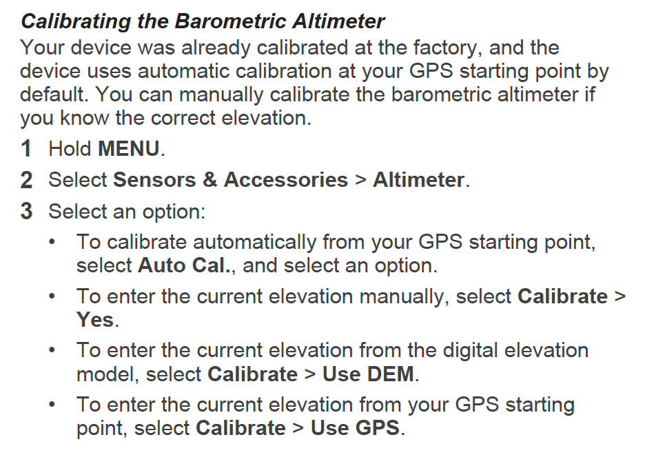
Try setting the starting elevation manually. From the user manual:
__________________
Ride, Rest, Repeat. ROUVY: terrymorse

Ride, Rest, Repeat. ROUVY: terrymorse
Last edited by terrymorse; 11-17-21 at 06:32 PM. Reason: formatting
05-31-21, 05:48 PM
#10
Junior Member

Join Date: Jun 2018
Location: L.A.
Posts: 139
Bikes: Giant Anyroad
Mentioned: 1 Post(s)
Tagged: 0 Thread(s)
Quoted: 44 Post(s)
Likes: 0
Liked 33 Times
in
22 Posts
In my experience the "enable elevation correction" is consistently wildly off and this is especially true on steep mountain trails with many turns, where I mostly ride The corrected route overshoots every turn and then adds countless feet as it has to "climb" back up to the trail. It is apparently also enabled in Garmin Connect route planning and can easily double the actual elevation gain. I use RWGPS now to plan routes and only rely on Garmin's disabled elev' correction for the actual ride data, which compares slightly conservatively to other devices/apps my riding partners use. I use an Edge Explore which is more limited than other Garmin units.
Last edited by Bingod; 05-31-21 at 05:51 PM.
05-31-21, 05:52 PM
#11
Senior Member
Join Date: May 2021
Posts: 219
Mentioned: 0 Post(s)
Tagged: 0 Thread(s)
Quoted: 111 Post(s)
Liked 69 Times
in
51 Posts
If the track hasn't been deleted, grabbing the track .gpx file from the unit will show what the elevations were.
Here's what the .gpx track log data looks like:
That's from a Garmin eTrex, the data from my Garmin Quatix watch is similar, so I'm assuming the Fenix would have the same basic format.
Everything else (speed, direction, etc. ) is calculated from that data for time, lat/lon and elevation.
Here's what the .gpx track log data looks like:
<time>2021-05-28T17:51:54Z</time>
</trkpt>
<trkpt lat="48.50746639" lon="-123.37282291">
<ele>107.810</ele>
<time>2021-05-28T17:51:55Z</time>
</trkpt>
<trkpt lat="48.50747779" lon="-123.37285149">
<ele>107.810</ele>
<time>2021-05-28T17:51:56Z</time>
</trkpt>
<trkpt lat="48.50749397" lon="-123.37287638">
<ele>107.810</ele>
</trkpt>
<trkpt lat="48.50746639" lon="-123.37282291">
<ele>107.810</ele>
<time>2021-05-28T17:51:55Z</time>
</trkpt>
<trkpt lat="48.50747779" lon="-123.37285149">
<ele>107.810</ele>
<time>2021-05-28T17:51:56Z</time>
</trkpt>
<trkpt lat="48.50749397" lon="-123.37287638">
<ele>107.810</ele>
Everything else (speed, direction, etc. ) is calculated from that data for time, lat/lon and elevation.
Last edited by VicBC_Biker; 05-31-21 at 05:56 PM.
05-31-21, 08:27 PM
#12
Senior Member
Join Date: May 2021
Location: San Francisco
Posts: 2,039
Bikes: addict, aethos, creo, vanmoof, sirrus, public ...
Mentioned: 2 Post(s)
Tagged: 0 Thread(s)
Quoted: 1279 Post(s)
Liked 1,393 Times
in
711 Posts
In my experience the "enable elevation correction" is consistently wildly off and this is especially true on steep mountain trails with many turns, where I mostly ride The corrected route overshoots every turn and then adds countless feet as it has to "climb" back up to the trail. It is apparently also enabled in Garmin Connect route planning and can easily double the actual elevation gain. I use RWGPS now to plan routes and only rely on Garmin's disabled elev' correction for the actual ride data, which compares slightly conservatively to other devices/apps my riding partners use. I use an Edge Explore which is more limited than other Garmin units.
05-31-21, 08:30 PM
#13
Guest
Join Date: Sep 2020
Posts: 2,888
Mentioned: 13 Post(s)
Tagged: 0 Thread(s)
Quoted: 1346 Post(s)
Liked 3,270 Times
in
1,439 Posts
Love how these labor-saving devices provide so much useful information that the experience of riding almost seems real. 
Likes For Rolla:
