


Garmin Etrex 20x
 11-27-23, 04:09 PM
#1
Count Orlok Member
Thread Starter
Garmin Etrex 20x
Someone has offered me a Garmin Etrex 20x for $50. They bought it for hiking but have never used it. While researching it, I came across this post:
From https://www.bikeforums.net/touring/1...ore-2-a-2.html
I currently use paper maps or routes figured out on Google maps and printed, and I use my bike computer to figure out how many miles I've gone and make my turns. I would only use my phone when I something went wrong, as I wanted to save battery power. This method sounds like it would work for me. I do have a few questions:
Kind of an aside comment..and undoubtedly I'm missing something, but these threads on navigation, where people have purchased 3, 4, 5 models of various higher/high-end garmin (or other) units always amazes me a bit. (I spent my career in tech and finished it crunching large data and developing computer models of transportation systems...not afraid of new technology..)
My entire tour navigation system consists of a $12 wireless bike computer that indicates speed, ave speed, distance covered and a Garmin Etrex 20 for navigation. Routes (actually tracks) are worked out on on a laptop using RWGPS. The tracks are then downloaded, transferred to Basecamp and then loaded into the Etrex 20. I also download a kml file from RWGPS and load that into Organic Maps on my cell phone..as a backup and easier to study version to reference as needed. The phone isn't used for active navigation..sucks too much power. I'd rather have a charged phone available for other tasks it does better.
This system never fails and the Etrex lasts a long time on two AA batts.
As I said..I'm sure I'm missing something with the more..exotic..systems. If I felt to need for something more I'd dive in..hasn't happened yet.
I currently use paper maps or routes figured out on Google maps and printed, and I use my bike computer to figure out how many miles I've gone and make my turns. I would only use my phone when I something went wrong, as I wanted to save battery power. This method sounds like it would work for me. I do have a few questions:
- Does the Etrex 20x display where one is on the prefigured route?
- Does the display show other roads? Say a road was closed for construction--could you figure out a different route?
- What programs can be used to figure routes? RWGPS? or will I have to buy maps from Garmin?
 11-27-23, 04:25 PM
#2
Senior Member
Join Date: Sep 2007
Location: Far beyond the pale horizon.
Posts: 14,278
Mentioned: 31 Post(s)
Tagged: 0 Thread(s)
Quoted: 4260 Post(s)
Liked 1,364 Times
in
945 Posts
- Yes.
- a: yes. b: yes (the on-device routing on the Edges can be a bit odd).
- a: Any route planner (including RWGPS). b: No. You can get free maps (don't buy them from Garmin.
There are eTrex 20x offered on eBay for $70+. I have no idea if people are buying them.
I'd guess that it wouldn't be too hard to sell it on eBay for about what you got this one for (if you ended up deciding it doesn't work for you).
So, this might be an opportunity to try it out.
==================
You can get free maps from the following (among other places):
https://garmin.bbbike.org/
The Edges need the Latin version of maps (unicode doesn't work on them). Not sure about the eTrex.
Last edited by njkayaker; 11-27-23 at 04:29 PM.
11-28-23, 08:23 AM
#4
Senior Member
Join Date: Jan 2009
Location: Central New Jersey
Posts: 427
Bikes: Burley Tandem
Mentioned: 0 Post(s)
Tagged: 0 Thread(s)
Quoted: 29 Post(s)
Likes: 0
Liked 11 Times
in
10 Posts
Someone has offered me a Garmin Etrex 20x for $50. They bought it for hiking but have never used it. While researching it, I came across this post:
I had given up on using my eTrex for anything other than a flight recorder to capture ride bread crumb trails, when I decided to buy the Edge device. It really comes down to if you're a gadget person or a paper person.
Last edited by DCwom; 11-28-23 at 08:28 AM.
11-28-23, 10:24 AM
#5
Senior Member
Join Date: Sep 2007
Location: Far beyond the pale horizon.
Posts: 14,278
Mentioned: 31 Post(s)
Tagged: 0 Thread(s)
Quoted: 4260 Post(s)
Liked 1,364 Times
in
945 Posts
Thanks njkayaker . From my reading, you seem to know these units really well.
Tourist in MSN uses a hiking GPS and has useful comments about that.
https://www.bikeforums.net/electroni...mendation.html
Note that I'm not saying it's the best option but there's no reason it can't work reasonably well.
It's just a low-risk option if you are "GPS curious". (But you have to include the issue of mounting it in your equation.)
Last edited by njkayaker; 11-28-23 at 10:29 AM.
11-28-23, 01:23 PM
#6
Senior Member
Join Date: Aug 2010
Location: Madison, WI
Posts: 11,211
Bikes: 1961 Ideor, 1966 Perfekt 3 Speed AB Hub, 1994 Bridgestone MB-6, 2006 Airnimal Joey, 2009 Thorn Sherpa, 2013 Thorn Nomad MkII, 2015 VO Pass Hunter, 2017 Lynskey Backroad, 2017 Raleigh Gran Prix, 1980s Bianchi Mixte on a trainer. Others are now gone.
Mentioned: 48 Post(s)
Tagged: 0 Thread(s)
Quoted: 3461 Post(s)
Liked 1,467 Times
in
1,144 Posts
That is discontinued, but that does not mean it is bad, just that Garmin has made some later models.
https://www.garmin.com/en-US/p/518046/pn/010-01508-00
There are cheaper after-market mounts, but the Garmin mounts do not cost much more, you can get Garmin ones from non-Garmin sources.
https://www.garmin.com/en-US/p/11411#devices
I find that the mount is less likely to rotate around the handlebar if you wrap a bit of innertube rubber around the bar first. Then the zip ties and mount stick to rubber better than a smooth handlebar. You could try skipping the rubber first, the Etrex is lighter than my GPS, maybe that is not needed?
These types of mounts are prone to user error on putting the GPS into the mount. I always use a tether so that if the GPS falls out of the mount, the GPS is still hanging from your handlebar by the tether (cord) instead of getting lost somewhere.
I like the Ikea 2450 AA Ladda batteries, which also need a recharger. Eneloop AA batteries are my close 2nd choice. Or, use disposables.
If you get it and start loading different maps into it, best to put the maps on a separate Micro SD card (no more than 32 gb). The internal memory might be limited if you try to put several maps in it.
I know a couple people that have used an Etrex series GPS for randonneuring and I use a non-cycling GPS for bike touring and for randonneuring brevets.
Likes For Tourist in MSN:
11-28-23, 02:02 PM
#7
Senior Member
Join Date: Sep 2007
Location: Far beyond the pale horizon.
Posts: 14,278
Mentioned: 31 Post(s)
Tagged: 0 Thread(s)
Quoted: 4260 Post(s)
Liked 1,364 Times
in
945 Posts
I�d suggest trying that before buying an SD card.
11-28-23, 04:41 PM
#8
Senior Member
Join Date: Feb 2016
Location: SE Wisconsin
Posts: 1,852
Bikes: Lemond '01 Maillot Jaune, Lemond '02 Victoire, Lemond '03 Poprad, Lemond '03 Wayzata DB conv(Poprad), '79 AcerMex Windsor Carrera Professional(pur new), '88 GT Tequesta(pur new), '01 Bianchi Grizzly, 1993 Trek 970 DB conv, Trek 8900 DB conv
Mentioned: 12 Post(s)
Tagged: 0 Thread(s)
Quoted: 759 Post(s)
Likes: 0
Liked 810 Times
in
471 Posts
- Does the Etrex 20x display where one is on the prefigured route?
- Yes, this is the key advantage of using any GPS unit. Paper maps are great if you're tracking landmarks or roads/trail signs are available to reference within the paper map. If you have a paper map and lack a on-route reference with respect to your location..then things are a bit tougher.
- Does the display show other roads? Say a road was closed for construction--could you figure out a different route?
- Yes, the base map in the Etrex 20 will show roads, however the detail isn't great. I loaded an upgraded map I found on the web and it was a nice improvement. This was a few years back. If you get the unit, let me know..maybe I can reconstruct what I did. A thorough search here on Bike Forums about installing alternate maps into Garmin GPS units may help. I downloaded an higher detail/better base map from...somewhere..and imported it into Garmin basecamp, then used Basecamp to update my Etrex 20.
- What programs can be used to figure routes? RWGPS? or will I have to buy maps from Garmin?
- I use RWGPS primarily and on a laptop or desktop computer. Create your map and then export a track. Import the track into Basecamp and then use Basecamp to transfer it to the Etrex 20 via the cable supplied with the Etrex unit.
$50 for an Etrex 20..seems reasonable to me.
As an aside..with each track I load into the Etrex, I also use RWGPS to export a KML format file. On your smart phone, install an app called "Organic Maps". Then download a map within Organic Maps of any area you'll be riding in(the map downloads are by state, or sections of a state, or in some cases large city files). This app will give you a very good and reliable off-line map on your phone. I've found it to be very accurate and it has a SURPRISINGLY large and accurate amount of hiking trails also included. Email the exported KML to yourself. Open(not download) the KML file on your phone and you'll get a dialogue screen asking whether you want to use Organic Maps to open it. Click yes. The KML file (track) will now be installed in your Organic Maps library. If you need to re-route while riding, then use your phone to do so. Organic Maps will have all the local roads wherever you are and it also has a routing function(much like Google Maps) if you need it.
12-01-23, 03:01 PM
#9
Senior Member
Second what DCwom said. For $50 you can get a better paperweight. It has about a zillion nice functions which I always found took about a zillion^2 to access. Hiking was better, but the screen is tiny and takes a lot of toggling to traverse etc. One time I got a lift around a bridge that was out and at the end of the day discovered my maximum speed was 45 mph! One advantage, it uses AA batteries so I could recharge them from a Dynohub, or a solar panel so one could really be independent that way.
12-09-23, 12:54 PM
#10
Count Orlok Member
Thread Starter
Here is my new Garmin Etrex20x:
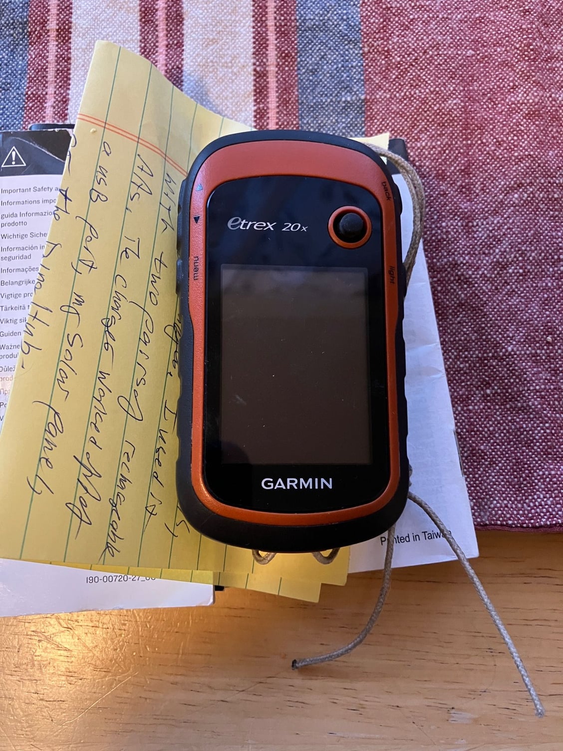
Pratt very generously sent me his Garmin, as 'tis the season. Thanks Pratt!
I will experiment with it on my commutes, and see if I can figure it out before touring next Summer. As asked above, I am really not a gadget person, but I've already found routes on RWGPS (US Bike Route 20, say) that I am interested in riding.
12-09-23, 04:21 PM
#11
Senior Member
Join Date: Feb 2016
Location: SE Wisconsin
Posts: 1,852
Bikes: Lemond '01 Maillot Jaune, Lemond '02 Victoire, Lemond '03 Poprad, Lemond '03 Wayzata DB conv(Poprad), '79 AcerMex Windsor Carrera Professional(pur new), '88 GT Tequesta(pur new), '01 Bianchi Grizzly, 1993 Trek 970 DB conv, Trek 8900 DB conv
Mentioned: 12 Post(s)
Tagged: 0 Thread(s)
Quoted: 759 Post(s)
Likes: 0
Liked 810 Times
in
471 Posts
Here is my new Garmin Etrex20x:
Pratt very generously sent me his Garmin, as 'tis the season. Thanks Pratt!
I will experiment with it on my commutes, and see if I can figure it out before touring next Summer. As asked above, I am really not a gadget person, but I've already found routes on RWGPS (US Bike Route 20, say) that I am interested in riding.
Looks good. When you download files from RWGPS be sure to download a GPX Track not a Route. Import it into Basecamp then use Basecamp to transfer it to the E-20..hopefully you have the usb cord that goes with the E-20.
If you any questions on setting it up..ask. It's pretty simple if you know how to use it. Loading up a track for a ride and starting the ride takes 4 toggle entries and about 3 seconds(not including turning the unit on). ..that can be pared down to 3 toggle entries if you choose to set up your home screen as the Track Manager.
12-09-23, 05:28 PM
#12
Senior Member
Join Date: Aug 2010
Location: Madison, WI
Posts: 11,211
Bikes: 1961 Ideor, 1966 Perfekt 3 Speed AB Hub, 1994 Bridgestone MB-6, 2006 Airnimal Joey, 2009 Thorn Sherpa, 2013 Thorn Nomad MkII, 2015 VO Pass Hunter, 2017 Lynskey Backroad, 2017 Raleigh Gran Prix, 1980s Bianchi Mixte on a trainer. Others are now gone.
Mentioned: 48 Post(s)
Tagged: 0 Thread(s)
Quoted: 3461 Post(s)
Liked 1,467 Times
in
1,144 Posts
You might be able to put a GPX file directly into the GPS unit from your computer. I assume you have the mini (not micro) USB cable for it. I assume it operates the way my Garmin 62 or 64 does.
When I connect my GPS via the cable to my windows based computer, the screen on my GPS has a weird symbol on it and the word Garmin that indicates it is connected.
From my computer, I can see two extra drives, or only one if there is no micro SD card in the GPS. On my computer, one is called D, the other E. The D drive is named Garmin GPSMAP and the model name. The E drive is named whatever name I gave to the micro SD card, if I named it.
In the drive that is Named Garmin GPSMAP <model namd>, the direcory called Garmin has a directory in it that is labled GPX. That is where my tracks, routes, waypoints, etc., are. If you have a GPX file for a track or route you want to ride, put a copy of that file into that GPX directory.
Then exit. Tell your computer to disconnect that drive. When I do that I get a note that it is safe to remove.
I unplug it and the GPS turns off.
I assume the Garmin manual tells you what to do at this point. The track shows up on the map screen, it is up to you to keep on that line.
12-10-23, 12:26 AM
#13
Senior Member
Join Date: Sep 2007
Location: Far beyond the pale horizon.
Posts: 14,278
Mentioned: 31 Post(s)
Tagged: 0 Thread(s)
Quoted: 4260 Post(s)
Liked 1,364 Times
in
945 Posts
You can copy files directly to the Etrex. It works just like your units do.
Last edited by njkayaker; 12-10-23 at 12:29 AM.
12-10-23, 12:29 AM
#14
Senior Member
Join Date: Sep 2007
Location: Far beyond the pale horizon.
Posts: 14,278
Mentioned: 31 Post(s)
Tagged: 0 Thread(s)
Quoted: 4260 Post(s)
Liked 1,364 Times
in
945 Posts
You can copy files directly to the unit. You don�t need to use BaseCamp.
Any USB data cable should work.
12-10-23, 09:28 AM
#15
Senior Member
Join Date: Aug 2010
Location: Madison, WI
Posts: 11,211
Bikes: 1961 Ideor, 1966 Perfekt 3 Speed AB Hub, 1994 Bridgestone MB-6, 2006 Airnimal Joey, 2009 Thorn Sherpa, 2013 Thorn Nomad MkII, 2015 VO Pass Hunter, 2017 Lynskey Backroad, 2017 Raleigh Gran Prix, 1980s Bianchi Mixte on a trainer. Others are now gone.
Mentioned: 48 Post(s)
Tagged: 0 Thread(s)
Quoted: 3461 Post(s)
Liked 1,467 Times
in
1,144 Posts
One more note on your new Etrex.
I find that when the GPS is configured to time out the screen (goes blank to save batteries after several seconds), sometimes I accidently leave it on thinking that I have already turned it off. That is a good way to deplete batteries so that you do not have any power when you wanted it.
Also, I don't like having to keep pushing a button to wake up the screen when I am on a bike navigating. So, I have my GPS units configured to keep the screen on. When I am approaching a turn in an urban area where there are lots of places to turn, so I am frequenly glancing at my GPS to see where the turn is, having the screen time out is quite inconvenient, especially if you are in traffic.
Since I run rechargeable batteries, it cost nothing to do a few experiments for battery life. So, I intentionally left my GPS on a few times, to see if leaving the screen on depletes the batteries faster, battery life is still pretty good with screen on all the time with no backlight.
But what kills the batteries is the backlight. With backlight on full, I had less than half the battery life that I would have with backlight off.
Thus, I have it configured to leave the screen on full time, but I am obsessive to make sure that my screen backlight is off unless I really need the backlight. And when my backlight is on, I only use the amount of backlight that I really need.
Generally, I only need backlight when the sun is low (early morning, or close to sunset) or after sundown. And when it is dark out, I can get by with my backlight at a very low setting. Heavy overcast or fog might also need some backlight.
If you have rechargeable batteries, you can start every ride with freshly charged batteries.
12-10-23, 11:22 AM
#16
Senior Member
Join Date: Feb 2016
Location: SE Wisconsin
Posts: 1,852
Bikes: Lemond '01 Maillot Jaune, Lemond '02 Victoire, Lemond '03 Poprad, Lemond '03 Wayzata DB conv(Poprad), '79 AcerMex Windsor Carrera Professional(pur new), '88 GT Tequesta(pur new), '01 Bianchi Grizzly, 1993 Trek 970 DB conv, Trek 8900 DB conv
Mentioned: 12 Post(s)
Tagged: 0 Thread(s)
Quoted: 759 Post(s)
Likes: 0
Liked 810 Times
in
471 Posts
???
Good to know, but doesn't matter (to me) as I have other reasons for doing so.
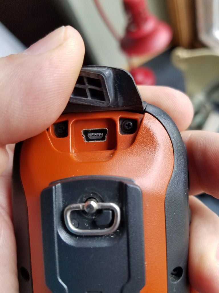
I don't think any USB cable will work. This isn't your standard micro-usb port, it's much (1-2mm) thicker than the std micro USB. Perhaps other years they used a standard connection, no idea.
 12-10-23, 12:05 PM
#17
Senior Member
Join Date: Sep 2007
Location: Far beyond the pale horizon.
Posts: 14,278
Mentioned: 31 Post(s)
Tagged: 0 Thread(s)
Quoted: 4260 Post(s)
Liked 1,364 Times
in
945 Posts
It would matter to the OP, since there is no requirement to use BaseCamp (which is more work).
It’s a “mini” USB, which is a different standard (older than “micro”). They aren't as common as mini but they are easy to get.
There are persistent rumors that only Garmin branded cables will work. Cables from any manufacturer will work. Obviously, the plug has to be compatible. https://en.wikipedia.org/wiki/USB_hardware
Last edited by njkayaker; 12-10-23 at 12:22 PM.
12-10-23, 12:37 PM
#18
Senior Member
Join Date: Aug 2010
Location: Madison, WI
Posts: 11,211
Bikes: 1961 Ideor, 1966 Perfekt 3 Speed AB Hub, 1994 Bridgestone MB-6, 2006 Airnimal Joey, 2009 Thorn Sherpa, 2013 Thorn Nomad MkII, 2015 VO Pass Hunter, 2017 Lynskey Backroad, 2017 Raleigh Gran Prix, 1980s Bianchi Mixte on a trainer. Others are now gone.
Mentioned: 48 Post(s)
Tagged: 0 Thread(s)
Quoted: 3461 Post(s)
Liked 1,467 Times
in
1,144 Posts
The mini USB cable is less common than they used to be, you probably will not find one at a Dollar store or a truck stop. A decade ago, you could buy them at Dollar stores, I did.
12-10-23, 02:06 PM
#19
Senior Member
Join Date: Feb 2016
Location: SE Wisconsin
Posts: 1,852
Bikes: Lemond '01 Maillot Jaune, Lemond '02 Victoire, Lemond '03 Poprad, Lemond '03 Wayzata DB conv(Poprad), '79 AcerMex Windsor Carrera Professional(pur new), '88 GT Tequesta(pur new), '01 Bianchi Grizzly, 1993 Trek 970 DB conv, Trek 8900 DB conv
Mentioned: 12 Post(s)
Tagged: 0 Thread(s)
Quoted: 759 Post(s)
Likes: 0
Liked 810 Times
in
471 Posts
An assumption on your part. The OP may indeed find some value in working with Basecamp. like keeping various tour files organized. No harm in getting to know what is does and how to use it. In his initial post it sounds like he's a blank slate in this path of navigating a tour.
I'm done. Debating you is a waste of time...back to the ignore status. Debating anyone on BF is a colossal waste of time.
OP..I hope the etrex works out for you. Make a little effort in learning how to use it (it's anything but a paperweight) and you'll be fine.
12-10-23, 02:16 PM
#20
Senior Member
Join Date: Sep 2007
Location: Far beyond the pale horizon.
Posts: 14,278
Mentioned: 31 Post(s)
Tagged: 0 Thread(s)
Quoted: 4260 Post(s)
Liked 1,364 Times
in
945 Posts
An assumption on your part. The OP may indeed find some value in working with Basecamp. like keeping various tour files organized. No harm in getting to know what is does and how to use it. In his initial post it sounds like he's a blank slate in this path of navigating a tour.
It appears yoou had no idea the files could be copied directly!
You were done before you started.
Last edited by njkayaker; 12-10-23 at 02:25 PM.
12-10-23, 02:59 PM
#21
Senior Member
Join Date: Jul 2007
Location: South shore, L.I., NY
Posts: 6,885
Bikes: Flyxii FR322, Cannondale Topstone, Miyata City Liner, Specialized Chisel, Specialized Epic Evo
Mentioned: 18 Post(s)
Tagged: 0 Thread(s)
Quoted: 3242 Post(s)
Liked 2,087 Times
in
1,182 Posts
It
It’s not a “micro” USB at all.
It’s a “mini” USB, which is a different standard (older than “micro”). They aren't as common as mini but they are easy to get.
There are persistent rumors that only Garmin branded cables will work. Cables from any manufacturer will work. Obviously, the plug has to be compatible. https://en.wikipedia.org/wiki/USB_hardware
12-10-23, 03:37 PM
#22
Senior Member
Join Date: Sep 2007
Location: Far beyond the pale horizon.
Posts: 14,278
Mentioned: 31 Post(s)
Tagged: 0 Thread(s)
Quoted: 4260 Post(s)
Liked 1,364 Times
in
945 Posts
I have encountered situations where some USB cables, when connected to my Edge 1000 or 1030, would not pass data to the PC Express software. Trial and error had me find certain cables that would allow the connection. I subsequently labeled those cables with a "G" to indicate I could use them with my Edge devices, so it's not a rumor, I have seen this happen. and it has been discussed more than a few times on the assorted FB Edge groups. I have no way of knowing if the cables that did work had been provided by Garmin and then thrown into the pile of assorted USB to mini/micro cables. This issue of "wrong" cable seemingly went away when Garmin moved to the USB-C standard on the 1040 (and others). I can use any USB - C cable on my 1040.
Ignoring the plug differences, there are two types of USB cables: 1- charging-only cables (*), 2- data cables (that can also charge).
I've never had any issues with any data cable with any mini or micro Garmin device (various models over many years).
Micro/mini USB cables are simple things: they are 4 wires (for data type) connected to the right pins. There's no place to hide magical behavior. It's possible there might be an issue with the quality of the cable but even that would be remote (USB cables are simple things). (USB-C cables are complicated. I suppose charging-only USB-C cables exist but I don't think these would be common.)
The rumor was that the cable had to be an explicit Garmin one. The devices come with a cable that has "Garmin" on it. (You wouldn't need to label the Garmin cable with "G". So, these are non-Garmin cables that work with the Garmins and also work for other stuff)
(One basis for the rumor is that Garmin asks people whether they are using the Garmin branded cable. They do that because it's an easy way to be sure people are using the right cable type.)
------------------------------------------
* Charging-only micro USB cables often come with rechargeable lights.
Last edited by njkayaker; 12-10-23 at 04:06 PM.
12-10-23, 03:38 PM
#23
Senior Member
Join Date: Aug 2010
Location: Madison, WI
Posts: 11,211
Bikes: 1961 Ideor, 1966 Perfekt 3 Speed AB Hub, 1994 Bridgestone MB-6, 2006 Airnimal Joey, 2009 Thorn Sherpa, 2013 Thorn Nomad MkII, 2015 VO Pass Hunter, 2017 Lynskey Backroad, 2017 Raleigh Gran Prix, 1980s Bianchi Mixte on a trainer. Others are now gone.
Mentioned: 48 Post(s)
Tagged: 0 Thread(s)
Quoted: 3461 Post(s)
Liked 1,467 Times
in
1,144 Posts
I do not think any of my USB Mini cables were provided by Garmin, most were bought on Ebay, shipped from Asia. But I bought some at Dollar Tree over a decade ago.
I have had one Mini USB cable not work as a data cable, it also had high resistance and would not pass much power for charging so I concluded it was defective and chucked it.
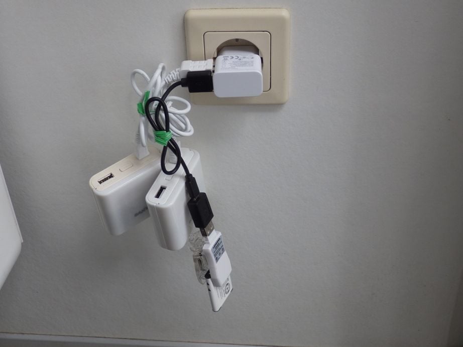
Some of my USB powered NiMH AA chargers also use the Mini USB cable, such as two of the chargers in the photo. But those are older chargers, the photo is over 7 years old.
If the OP does not have a Mini USB cable, he needs one for data transfer, which I mentioned in the first paragraph of post 12, above.
The photo above is from the last trip I did with one of the old Garmin GPS units with a black and white display, I could not charge AA batteries in the GPS so I had to carry more AA batteries on a long bike tour. Now I can charge NiMH AA batteries in my Garmin 64. (Garmin will tell you that it won't work but I used a work around so I can.) But I still need the Mini USB cable to do that.
I have had one Mini USB cable not work as a data cable, it also had high resistance and would not pass much power for charging so I concluded it was defective and chucked it.
Some of my USB powered NiMH AA chargers also use the Mini USB cable, such as two of the chargers in the photo. But those are older chargers, the photo is over 7 years old.
If the OP does not have a Mini USB cable, he needs one for data transfer, which I mentioned in the first paragraph of post 12, above.
The photo above is from the last trip I did with one of the old Garmin GPS units with a black and white display, I could not charge AA batteries in the GPS so I had to carry more AA batteries on a long bike tour. Now I can charge NiMH AA batteries in my Garmin 64. (Garmin will tell you that it won't work but I used a work around so I can.) But I still need the Mini USB cable to do that.
12-10-23, 04:59 PM
#24
Count Orlok Member
Thread Starter
Thanks everyone. I appreciate everyone trying to help me, but let's cool down the tempers a little.
I have a variety of Mini USB cables and the first one I tried works fine. I'll try a few others.
I created both my morning commute and afternoon commute in RWGPS, and saved them as GPX files. I could not choose to save on the eTrex, so I saved to my computer and copied them into the GPX folder on the Garmin. One shows up in Routes; the other in Tracks. Not really sure why.
I need to play around with it more, but I'll see if I can try it here in the next two weeks and figure out how to use it on tour.
12-10-23, 05:18 PM
#25
Senior Member
Join Date: Sep 2007
Location: Far beyond the pale horizon.
Posts: 14,278
Mentioned: 31 Post(s)
Tagged: 0 Thread(s)
Quoted: 4260 Post(s)
Liked 1,364 Times
in
945 Posts
I created both my morning commute and afternoon commute in RWGPS, and saved them as GPX files. I could not choose to save on the eTrex, so I saved to my computer and copied them into the GPX folder on the Garmin. One shows up in Routes; the other in Tracks. Not really sure why.
Track files have enough points to trace the curves and turns of your intended path. On the Edges (at least), the "fancy" navigation follows the track (as best it can). Track files originally were recorded tracks. That sort still exists but things like RWGPS create synthetic ones.
Route files have a few points (waypoints) that indicate the places you must pass through. With route files, the device has to calculate the route ("fancy" navigation) between the waypoints. (The Edges can't use route files at all.)
It's a bit confusing because "route" is also used generically. For example, you create a route in RWGPS but can create a track GPX file and a route GPX file from it.
I suspect the files are in two lists because you chose different export options in RWGP (track for one and route for the other).
Last edited by njkayaker; 12-10-23 at 05:28 PM.
Likes For njkayaker: