


Phone GPS wonky
 02-20-24, 08:53 AM
#1
Senior Member
Thread Starter
Join Date: Dec 2010
Location: northern Deep South
Posts: 8,904
Bikes: Fuji Touring, Novara Randonee
Mentioned: 36 Post(s)
Tagged: 0 Thread(s)
Quoted: 2604 Post(s)
Liked 1,933 Times
in
1,213 Posts
Phone GPS wonky
I've been using either Strava or RidewithGPS on my phone to let my wife track me during my rides. Recently, both have started showing some spurious points that drive her (and therefore me too!) nuts. While riding, the track show I'm following the road, and then there's a point a quarter mile off in a cornfield then back to the road in a sawtooth route, or it looks like I hiked into the woods and came back and kept riding. I sort of like these rides because I get a track a quarter to a third longer than what I actually rode. But SWMBO is afraid she'll run into rattlesnakes or bears if she has to come looking for me. 
Subject phone is just under two years old, Samsung A23.
Is there a way to apply some more filtering to the phone's GPS, or force either app to use a sanity check to smooth the track out?
Subject phone is just under two years old, Samsung A23.
Is there a way to apply some more filtering to the phone's GPS, or force either app to use a sanity check to smooth the track out?
 02-20-24, 09:22 AM
#2

I'm good to go!
Join Date: Jul 2017
Location: Mississippi
Posts: 15,002
Bikes: Tarmac Disc Comp Di2 - 2020
Mentioned: 51 Post(s)
Tagged: 0 Thread(s)
Quoted: 6198 Post(s)
Liked 4,814 Times
in
3,321 Posts
You just have to face the fact that your phones GPS will face some challenges because of the way it's implemented in the phone. Along with how and when it establishes and shares your location. My wife and I have been sharing location with each other for over a dozen years now. And all of our phones have been subject to reporting my or my wife's location in the wrong place occasionally.
Perhaps ensuring that the apps you are using for this have permission to use your GPS whenever they want might help with some false reports.
Perhaps ensuring that the apps you are using for this have permission to use your GPS whenever they want might help with some false reports.
02-20-24, 07:31 PM
#3
Senior Member
Join Date: Aug 2010
Location: Madison, WI
Posts: 11,214
Bikes: 1961 Ideor, 1966 Perfekt 3 Speed AB Hub, 1994 Bridgestone MB-6, 2006 Airnimal Joey, 2009 Thorn Sherpa, 2013 Thorn Nomad MkII, 2015 VO Pass Hunter, 2017 Lynskey Backroad, 2017 Raleigh Gran Prix, 1980s Bianchi Mixte on a trainer. Others are now gone.
Mentioned: 48 Post(s)
Tagged: 0 Thread(s)
Quoted: 3462 Post(s)
Liked 1,468 Times
in
1,145 Posts
... ... While riding, the track show I'm following the road, and then there's a point a quarter mile off in a cornfield then back to the road in a sawtooth route, or it looks like I hiked into the woods and came back and kept riding. ...
...
Is there a way to apply some more filtering to the phone's GPS, or force either app to use a sanity check to smooth the track out?
...
Is there a way to apply some more filtering to the phone's GPS, or force either app to use a sanity check to smooth the track out?
I suspect that the GPS has old data in it for some of the satellite orbits, and as some satellites move further away and another satellite comes into view, if the data on the orbit is old for the one that just came into view, I suspect that it plots the location using old data with some error. This is only a guess on my part.
If my guess is correct, the best solution is have your GPS turned on more often to load more recent orbit data for all satellites into it.
02-20-24, 07:41 PM
#4
Senior Member
Join Date: Jul 2007
Location: South shore, L.I., NY
Posts: 6,886
Bikes: Flyxii FR322, Cannondale Topstone, Miyata City Liner, Specialized Chisel, Specialized Epic Evo
Mentioned: 18 Post(s)
Tagged: 0 Thread(s)
Quoted: 3242 Post(s)
Liked 2,089 Times
in
1,182 Posts
I do not know why this happens, but i have occasionally seen it over the years in some of my tracks. It only seems to happen when my GPS has not been used regularly for weeks.
I suspect that the GPS has old data in it for some of the satellite orbits, and as some satellites move further away and another satellite comes into view, if the data on the orbit is old for the one that just came into view, I suspect that it plots the location using old data with some error. This is only a guess on my part.
If my guess is correct, the best solution is have your GPS turned on more often to load more recent orbit data for all satellites into it.
02-21-24, 06:15 AM
#5
Senior Member
Join Date: Sep 2007
Location: Far beyond the pale horizon.
Posts: 14,278
Mentioned: 31 Post(s)
Tagged: 0 Thread(s)
Quoted: 4260 Post(s)
Liked 1,364 Times
in
945 Posts
No, the phones don�t have it on continuously. It would use way too much battery life.
You get location quickly because the phone can get approximate location from not just GPS like cell towers.
https://en.wikipedia.org/wiki/Assisted_GNSS
You get location quickly because the phone can get approximate location from not just GPS like cell towers.
https://en.wikipedia.org/wiki/Assisted_GNSS
02-21-24, 06:22 AM
#6
Senior Member
Join Date: Sep 2007
Location: Far beyond the pale horizon.
Posts: 14,278
Mentioned: 31 Post(s)
Tagged: 0 Thread(s)
Quoted: 4260 Post(s)
Liked 1,364 Times
in
945 Posts
I do not know why this happens, but i have occasionally seen it over the years in some of my tracks. It only seems to happen when my GPS has not been used regularly for weeks.
I suspect that the GPS has old data in it for some of the satellite orbits, and as some satellites move further away and another satellite comes into view, if the data on the orbit is old for the one that just came into view, I suspect that it plots the location using old data with some error. This is only a guess on my part.
If my guess is correct, the best solution is have your GPS turned on more often to load more recent orbit data for all satellites into it.
I suspect that the GPS has old data in it for some of the satellite orbits, and as some satellites move further away and another satellite comes into view, if the data on the orbit is old for the one that just came into view, I suspect that it plots the location using old data with some error. This is only a guess on my part.
If my guess is correct, the best solution is have your GPS turned on more often to load more recent orbit data for all satellites into it.
https://en.wikipedia.org/wiki/Assisted_GNSS
02-21-24, 06:30 AM
#7
Senior Member
Join Date: Sep 2007
Location: Far beyond the pale horizon.
Posts: 14,278
Mentioned: 31 Post(s)
Tagged: 0 Thread(s)
Quoted: 4260 Post(s)
Liked 1,364 Times
in
945 Posts
I've been using either Strava or RidewithGPS on my phone to let my wife track me during my rides. Recently, both have started showing some spurious points that drive her (and therefore me too!) nuts. While riding, the track show I'm following the road, and then there's a point a quarter mile off in a cornfield then back to the road in a sawtooth route, or it looks like I hiked into the woods and came back and kept riding. I sort of like these rides because I get a track a quarter to a third longer than what I actually rode. But SWMBO is afraid she'll run into rattlesnakes or bears if she has to come looking for me.
Subject phone is just under two years old, Samsung A23.
Is there a way to apply some more filtering to the phone's GPS, or force either app to use a sanity check to smooth the track out?
Subject phone is just under two years old, Samsung A23.
Is there a way to apply some more filtering to the phone's GPS, or force either app to use a sanity check to smooth the track out?
If it�s �recent�, that suggests the phone hardware is not working properly.
02-21-24, 06:35 AM
#8
Senior Member
Join Date: Aug 2010
Location: Madison, WI
Posts: 11,214
Bikes: 1961 Ideor, 1966 Perfekt 3 Speed AB Hub, 1994 Bridgestone MB-6, 2006 Airnimal Joey, 2009 Thorn Sherpa, 2013 Thorn Nomad MkII, 2015 VO Pass Hunter, 2017 Lynskey Backroad, 2017 Raleigh Gran Prix, 1980s Bianchi Mixte on a trainer. Others are now gone.
Mentioned: 48 Post(s)
Tagged: 0 Thread(s)
Quoted: 3462 Post(s)
Liked 1,468 Times
in
1,145 Posts
02-21-24, 07:10 AM
#10
Newbie

Military can occasionally scrabble and goof with GPS satellites signals.
This is Part of homeland security, and or other governments.
This is Part of homeland security, and or other governments.
02-21-24, 08:53 AM
#12
Senior Member
Thread Starter
Join Date: Dec 2010
Location: northern Deep South
Posts: 8,904
Bikes: Fuji Touring, Novara Randonee
Mentioned: 36 Post(s)
Tagged: 0 Thread(s)
Quoted: 2604 Post(s)
Liked 1,933 Times
in
1,213 Posts
02-21-24, 09:46 AM
#13
...
Join Date: Oct 2021
Location: Whitestone and Rensselaerville, New York
Posts: 1,519
Bikes: Bicycles? Yup.
Mentioned: 8 Post(s)
Tagged: 0 Thread(s)
Quoted: 482 Post(s)
Liked 1,593 Times
in
739 Posts
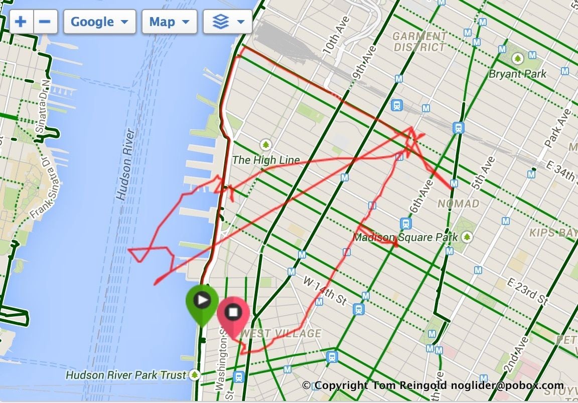
My favorite GPS snafu was riding in downtown Manhattan, signal probably got bounced off of buildings and Strava showed a totally vertical rise of >900 feet. Looked like an elevator ride.
 02-21-24, 10:13 AM
#14
I'm good to go!
Join Date: Jul 2017
Location: Mississippi
Posts: 15,002
Bikes: Tarmac Disc Comp Di2 - 2020
Mentioned: 51 Post(s)
Tagged: 0 Thread(s)
Quoted: 6198 Post(s)
Liked 4,814 Times
in
3,321 Posts
I guess one other thing that you need to consider is where your phone is. Do you have it mounted next to a video camera or a flashing light. Many aren't a bother for GPS's but some are.
02-21-24, 12:16 PM
#15
Senior Member
Join Date: Aug 2010
Location: Madison, WI
Posts: 11,214
Bikes: 1961 Ideor, 1966 Perfekt 3 Speed AB Hub, 1994 Bridgestone MB-6, 2006 Airnimal Joey, 2009 Thorn Sherpa, 2013 Thorn Nomad MkII, 2015 VO Pass Hunter, 2017 Lynskey Backroad, 2017 Raleigh Gran Prix, 1980s Bianchi Mixte on a trainer. Others are now gone.
Mentioned: 48 Post(s)
Tagged: 0 Thread(s)
Quoted: 3462 Post(s)
Liked 1,468 Times
in
1,145 Posts
Parts of downtown Chicago have an elevated train, I think same with NY. I have lost signal under those in Chicago.
02-21-24, 12:40 PM
#16
Senior Member
Join Date: Aug 2010
Location: Madison, WI
Posts: 11,214
Bikes: 1961 Ideor, 1966 Perfekt 3 Speed AB Hub, 1994 Bridgestone MB-6, 2006 Airnimal Joey, 2009 Thorn Sherpa, 2013 Thorn Nomad MkII, 2015 VO Pass Hunter, 2017 Lynskey Backroad, 2017 Raleigh Gran Prix, 1980s Bianchi Mixte on a trainer. Others are now gone.
Mentioned: 48 Post(s)
Tagged: 0 Thread(s)
Quoted: 3462 Post(s)
Liked 1,468 Times
in
1,145 Posts
If the military messed with it, it would probably be to disrupt missile targeting, in which case I suspect most of us would be happy they messed with it.
I needed to get some land surveyed over a decade ago. Met the land surveys on site. They were using GPS. They said that the section corner in county records was off by 0.07 feet, or else the marker had moved. I told them that snow plows had moved the section corner monument before, likely would happen again. I was surprised at their level of accuracy, but they were less than a quarter mile from the differential station that they had set up at the town hall.
That said, short range jamming and spoofing is common on the battlefield.
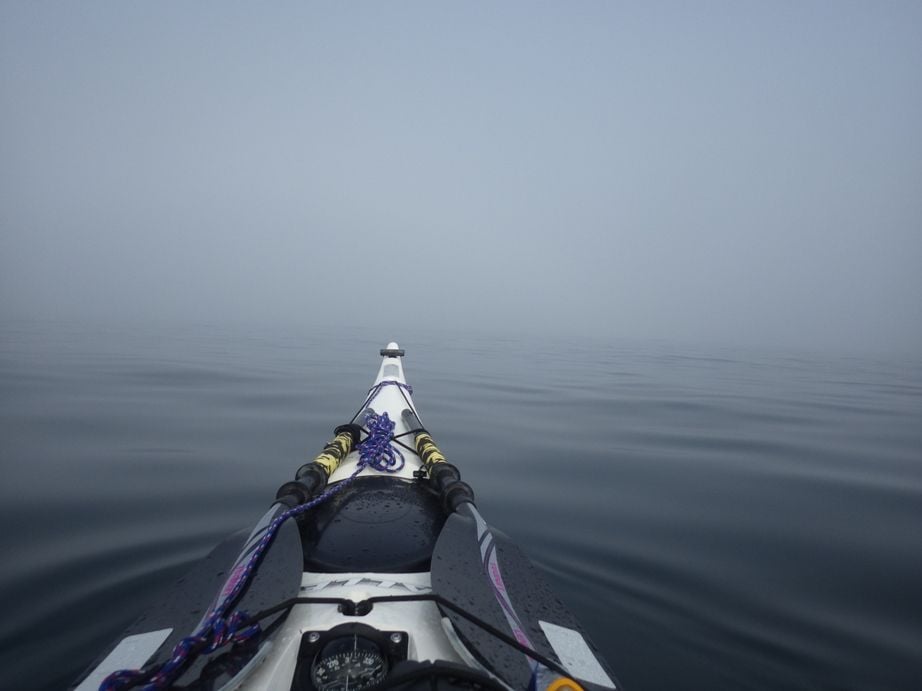
Speaking of fog, that is the reason I bought my first GPS over two decades ago. If you are paddling your kayak towards an island, and accidently miss it, you could have a bad day.
 02-21-24, 07:19 PM
#17
Long time part timer
maybe it's the phone?
Disclaimer: I am not a GPS expert.
I had been using RWGPS with an Android phone for tracking my rides. After three or so years it just started to lose tracking randomly - like I'd have a straight line going over a bay or between places where there are no roads. I contacted RWGPS support (who were very helpful) and started troubleshooting. At first they had me download a "GPS Test" app which will test your phone's recognition of satellites - both in number and strength. So maybe give that a try.
Ultimately, the problem ended up being my phone: RWGPS' software would not play nicely with the older Android OS I had, which from memory was maybe 3 versions behind. I got a new phone and have had no problems since.
YMMV. Good luck.
02-22-24, 03:57 AM
#18
Senior Member
Join Date: Aug 2010
Location: Madison, WI
Posts: 11,214
Bikes: 1961 Ideor, 1966 Perfekt 3 Speed AB Hub, 1994 Bridgestone MB-6, 2006 Airnimal Joey, 2009 Thorn Sherpa, 2013 Thorn Nomad MkII, 2015 VO Pass Hunter, 2017 Lynskey Backroad, 2017 Raleigh Gran Prix, 1980s Bianchi Mixte on a trainer. Others are now gone.
Mentioned: 48 Post(s)
Tagged: 0 Thread(s)
Quoted: 3462 Post(s)
Liked 1,468 Times
in
1,145 Posts
Thanks for the update. Maybe that is why Maps.Me stopped working well on my Android 7 phone? Phone works fine, but that app started mis-behaving. That said, I only used Maps.Me as a backup if my dedicated GPS stopped working, so not buying a new phone for a while.
02-22-24, 08:24 AM
#19
aka Tom Reingold

Join Date: Jan 2009
Location: New York, NY, and High Falls, NY, USA
Posts: 40,506
Bikes: 1962 Rudge Sports, 1971 Raleigh Super Course, 1971 Raleigh Pro Track, 1974 Raleigh International, 1975 Viscount Fixie, 1982 McLean, 1996 Lemond (Ti), 2002 Burley Zydeco tandem
Mentioned: 511 Post(s)
Tagged: 0 Thread(s)
Quoted: 7352 Post(s)
Liked 2,479 Times
in
1,439 Posts
Yes, it happens to me, especially in Manhattan. Cloud cover also weighs in to create errors. It's usually not this bad. Sometimes it shows me surging to 50 mph, which I'm sure I never do on flat ground. Also, I'm sure I didn't ride through buildings or out onto the river.
__________________
Tom Reingold, tom@noglider.com
New York City and High Falls, NY
Blogs: The Experienced Cyclist; noglider's ride blog
�When man invented the bicycle he reached the peak of his attainments.� � Elizabeth West, US author
Please email me rather than PM'ing me. Thanks.
Tom Reingold, tom@noglider.com
New York City and High Falls, NY
Blogs: The Experienced Cyclist; noglider's ride blog
�When man invented the bicycle he reached the peak of his attainments.� � Elizabeth West, US author
Please email me rather than PM'ing me. Thanks.
02-22-24, 10:53 AM
#20
Senior Member
Join Date: Jul 2007
Location: South shore, L.I., NY
Posts: 6,886
Bikes: Flyxii FR322, Cannondale Topstone, Miyata City Liner, Specialized Chisel, Specialized Epic Evo
Mentioned: 18 Post(s)
Tagged: 0 Thread(s)
Quoted: 3242 Post(s)
Liked 2,089 Times
in
1,182 Posts
Yes, it happens to me, especially in Manhattan. Cloud cover also weighs in to create errors. It's usually not this bad. Sometimes it shows me surging to 50 mph, which I'm sure I never do on flat ground. Also, I'm sure I didn't ride through buildings or out onto the river.
02-22-24, 01:31 PM
#21
I'm good to go!
Join Date: Jul 2017
Location: Mississippi
Posts: 15,002
Bikes: Tarmac Disc Comp Di2 - 2020
Mentioned: 51 Post(s)
Tagged: 0 Thread(s)
Quoted: 6198 Post(s)
Liked 4,814 Times
in
3,321 Posts
You don't have a Garmin device that does livetracking? It still needs your phone to send the data to your spouse, but the GPS info is usually less prone to the weird times that phone location has you sitting somewhere for several minutes. Usually if they show you somewhere else, it's only for that one brief hit.
02-22-24, 03:39 PM
#22
aka Tom Reingold
Join Date: Jan 2009
Location: New York, NY, and High Falls, NY, USA
Posts: 40,506
Bikes: 1962 Rudge Sports, 1971 Raleigh Super Course, 1971 Raleigh Pro Track, 1974 Raleigh International, 1975 Viscount Fixie, 1982 McLean, 1996 Lemond (Ti), 2002 Burley Zydeco tandem
Mentioned: 511 Post(s)
Tagged: 0 Thread(s)
Quoted: 7352 Post(s)
Liked 2,479 Times
in
1,439 Posts
Yeah, I know. I just wanted to say it with my little quips and map. Whenever it happens, I chuckle.
__________________
Tom Reingold, tom@noglider.com
New York City and High Falls, NY
Blogs: The Experienced Cyclist; noglider's ride blog
�When man invented the bicycle he reached the peak of his attainments.� � Elizabeth West, US author
Please email me rather than PM'ing me. Thanks.
Tom Reingold, tom@noglider.com
New York City and High Falls, NY
Blogs: The Experienced Cyclist; noglider's ride blog
�When man invented the bicycle he reached the peak of his attainments.� � Elizabeth West, US author
Please email me rather than PM'ing me. Thanks.
02-26-24, 08:45 AM
#23
Newbie
I've been using either Strava or RidewithGPS on my phone to let my wife track me during my rides. Recently, both have started showing some spurious points that drive her (and therefore me too!) nuts. While riding, the track show I'm following the road, and then there's a point a quarter mile off in a cornfield then back to the road in a sawtooth route, or it looks like I hiked into the woods and came back and kept riding. I sort of like these rides because I get a track a quarter to a third longer than what I actually rode. But SWMBO is afraid she'll run into rattlesnakes or bears if she has to come looking for me.
Subject phone is just under two years old, Samsung A23.
Is there a way to apply some more filtering to the phone's GPS, or force either app to use a sanity check to smooth the track out?
Subject phone is just under two years old, Samsung A23.
Is there a way to apply some more filtering to the phone's GPS, or force either app to use a sanity check to smooth the track out?
you can improve accuracy by turning on high accuracy or gps signal filtering within app settings.
