


C&O Current Conditions?
 08-01-19, 03:40 AM
#1
Senior Member
Thread Starter
C&O Current Conditions?
My 14yo son and I are riding the C&O this Saturday-Monday from Cumberland to DC. Looking for any recent (past week or so) updates on trail conditions (overly muddy?). Yes, I have looked at the NPS site with the alerts so am up to speed on those (https://www.nps.gov/choh/planyourvisit/conditions.htm). I have biked the C&O before both end to end and in sections, as well as the GAP three or four times, so I know what we're getting into. Doing a self-supported, credit-card tour. Thanks!
 08-01-19, 04:31 AM
#2
Senior Member
It has been almost 2 weeks now but did a 6 mile hike on the C&O from Brunswick downstream. The temporary bridge has been up for a while, that is fine but the construction traffic had left a lot of wheel ruts on the towpath in and out, that stretch was worse than usual.
Outside of that, the typical areas that get muddy were pretty dry. We've had about 1 inch of rain since then, last night's storms seemed to stay south of the Potomac. The forecast is for various scattered showers, so my guess is you won't hit anything close to the epic mud pits like last year but you will get spattered.
Since you are familiar with it, overall I'd guess it is pretty average conditions right now, you'll have to see how much rain falls over the next few days.
 08-01-19, 02:13 PM
#4
Senior Member
Thread Starter
Thanks! Fingers crossed for no big dumps of rain over the weekend.
08-02-19, 10:04 AM
#5
Senior Member
Join Date: May 2010
Posts: 745
Mentioned: 4 Post(s)
Tagged: 0 Thread(s)
Quoted: 188 Post(s)
Likes: 0
Liked 3 Times
in
3 Posts
We did the C&O last weekend, there's a detour around Williamsport that could be a little better marked going North to South. The detour brings you into a section of the C&O that requires you to hump your bike up and down stairs to cross a foot bridge over the canal. Someone on the trail said there was a better way and that the detour wasn't properly marked. Not so sure what the better route is but it kind of sucked humping our bikes across the bridge. Other than that the trail was rough as usual with lots of muddy spots on the trail but there are now sections around Harpers Ferry where they are adding crushed limestone or something similar that make riding better and of course the paved Western Maryland Rail Trail can't be beat, unless you're a purist and want to stick to the C&O... My daughter said something about a closure around MM 14 that was going into effect this week, but am not sure what the duration is/was. I know MM 21'ish to 16 was supposed to be closed last weekend for tree removal but we skirted the trail closed signs and rode through without issue. There were also two trees down somewhere in the mid 20's mile marker area but there was already a path around them when we arrived, I'm assuming they've been addressed now.
Oh yeah, the mosquito's were out with a vengeance this year...
Oh yeah, the mosquito's were out with a vengeance this year...
Last edited by edthesped; 08-02-19 at 10:12 AM.
08-03-19, 03:49 AM
#6
Member
Join Date: Sep 2006
Posts: 43
Mentioned: 1 Post(s)
Tagged: 0 Thread(s)
Quoted: 15 Post(s)
Liked 0 Times
in
0 Posts
Just finished the trail, Cumberland to Washington DC, yesterday. No closures...unless you count the Williamsport detour. Not sure about a better detour route in Williamsport, but I thought it was signed pretty well...and I was leading a group of 10...7 of them teenaged boys.
Coming onto Harper's Ferry, where the new surface begins, it is not very well packed. It not only robs you of speed but your tires can slide out...just watch yourself.
All temporary closures from downed trees were open. There are still a couple of temporary bridges or footbridges, but not real issues.
If staying at hiker/biker campsites, most tended to be fairly over grown.
08-04-19, 03:43 PM
#7
Senior Member
Did a 6 mile hike on the C&O Towpath near Sharpsburg early this (Sunday) morning - looks like you had phenomenal Towpath conditions!
08-05-19, 07:28 AM
#8
Senior Member
Join Date: May 2010
Posts: 745
Mentioned: 4 Post(s)
Tagged: 0 Thread(s)
Quoted: 188 Post(s)
Likes: 0
Liked 3 Times
in
3 Posts
Just finished the trail, Cumberland to Washington DC, yesterday. No closures...unless you count the Williamsport detour. Not sure about a better detour route in Williamsport, but I thought it was signed pretty well...and I was leading a group of 10...7 of them teenaged boys.
Coming onto Harper's Ferry, where the new surface begins, it is not very well packed. It not only robs you of speed but your tires can slide out...just watch yourself.
All temporary closures from downed trees were open. There are still a couple of temporary bridges or footbridges, but not real issues.
If staying at hiker/biker campsites, most tended to be fairly over grown.
Coming onto Harper's Ferry, where the new surface begins, it is not very well packed. It not only robs you of speed but your tires can slide out...just watch yourself.
All temporary closures from downed trees were open. There are still a couple of temporary bridges or footbridges, but not real issues.
If staying at hiker/biker campsites, most tended to be fairly over grown.
My experience on the new surface was the opposite of yours I was quite pleased to not have to dodge mud holes and ruts, though judging by the equipment on and near the trail, the work is ongoing so you may have experienced a newer section that wasn't yet laid down when we went through. We rode with 40mm tires @ 45 PSI and rolled quite nicely, we run tubeless if it makes a difference.
I agree with the hiker biker campgrounds, though my daughter who has turned the Pgh to DC trip in to an annual ride says there was nothing atypical about the conditions of the sites. I did the C&O several years back with the Boy Scouts and don't remember them being as primitive but my daughter insists they've been like that, as I made the same observation as you.
08-06-19, 08:42 AM
#9
Senior Member

Did you go north to south? If so, were you able to keep from hauling your bikes up and over the foot bridge? Supposedly there's a better route that allows one to avoid the stairs over the bridge, unfortunately I'm not sure what it is but was told rather than dropping into the park at the last sign I should have stayed on the road for a bit more. I don't want to mislead anyone as I took the stairs and foot bridge as the final sign at the park implied. Looking at google maps maybe there's some way to come down W Salsbury St. but I'm not sure I'd risk it without knowing for sure.
My experience on the new surface was the opposite of yours I was quite pleased to not have to dodge mud holes and ruts, though judging by the equipment on and near the trail, the work is ongoing so you may have experienced a newer section that wasn't yet laid down when we went through. We rode with 40mm tires @ 45 PSI and rolled quite nicely, we run tubeless if it makes a difference.
I agree with the hiker biker campgrounds, though my daughter who has turned the Pgh to DC trip in to an annual ride says there was nothing atypical about the conditions of the sites. I did the C&O several years back with the Boy Scouts and don't remember them being as primitive but my daughter insists they've been like that, as I made the same observation as you.
08-06-19, 12:06 PM
#10
Member
Join Date: Sep 2006
Posts: 43
Mentioned: 1 Post(s)
Tagged: 0 Thread(s)
Quoted: 15 Post(s)
Liked 0 Times
in
0 Posts
Did you go north to south? If so, were you able to keep from hauling your bikes up and over the foot bridge? Supposedly there's a better route that allows one to avoid the stairs over the bridge, unfortunately I'm not sure what it is but was told rather than dropping into the park at the last sign I should have stayed on the road for a bit more. I don't want to mislead anyone as I took the stairs and foot bridge as the final sign at the park implied. Looking at google maps maybe there's some way to come down W Salsbury St. but I'm not sure I'd risk it without knowing for sure.
My experience on the new surface was the opposite of yours I was quite pleased to not have to dodge mud holes and ruts, though judging by the equipment on and near the trail, the work is ongoing so you may have experienced a newer section that wasn't yet laid down when we went through. We rode with 40mm tires @ 45 PSI and rolled quite nicely, we run tubeless if it makes a difference.
I agree with the hiker biker campgrounds, though my daughter who has turned the Pgh to DC trip in to an annual ride says there was nothing atypical about the conditions of the sites. I did the C&O several years back with the Boy Scouts and don't remember them being as primitive but my daughter insists they've been like that, as I made the same observation as you.

The new surface was great...at least the areas that were packed. Our first couple of miles (or so) was pretty loose. Granted my bike currently has 32 mm tires so that, plus the weight, were the issues. I almost went down...but didn't. Though it did leave a pretty cool looking "scar" in the surface for those behind me to look at.
Yea, the boys in our group, who had never camped before, preferred the more manicured campsites we had earlier at a couple of boat ramps. I thought they were fine...nothing special but did exactly what we needed--gave us a place to sleep, get water, and go to the bathroom.
Great trip! When I can do it again I would like to take a little more time to "stop and smell the roses"...which was difficult with a large group of youth.
08-07-19, 08:24 AM
#11
Senior Member
Join Date: May 2010
Posts: 745
Mentioned: 4 Post(s)
Tagged: 0 Thread(s)
Quoted: 188 Post(s)
Likes: 0
Liked 3 Times
in
3 Posts
Does anyone know what the resurfacing plans are? It would sure be nice if they do the whole thing. As an aside, if someone else is going north to south and choose to ride the WMRT be sure to follow the signage for the C&O close to the trail as there's no way to get back on the towpath at the end of the WMRT. We almost blew by it but fortunately did not.
08-07-19, 05:23 PM
#12
Every day a winding road

When I went through, they were actively resurfacing a section just north-west of the Hapers Ferry bridge. The part that was fully complete was fine, but then I hit a section that was in process that was loose, and unpleasant, and I ended up riding on the edge of the trail. I think there's a stage where they put loose material down, and then a stage where they pack it down. If you hit it before it's been packed down, look out. To my eyes, the surfaces looked the same, but one was firm and flat, and one my tires sunk into. I also had to negotiate passing the vehicles working on the trail, which was more unpleasant than the trail itself, but they were all accommodating, and it wasn't a very long section.
08-07-19, 05:33 PM
#13
Senior Member
I was surprised, too, but there was a pavement stretch southeast of Harper's that appeared to have been there for a while. New surface looked like it would extend the pavement a couple of miles northwest of the Harper's. And I think there's some pavement going into DC, but not the whole way. Although there is pavement paralleling some stretches as you approach downtown. I got some weird looks for riding the dirt when the pavement was right there, but I was like, "I've been on this trail for 180 miles. I'm not skipping the last 6."
08-08-19, 05:25 AM
#14
Senior Member
Centered around Hancock MD, the Western Maryland RailRoad trail is a paved trail that runs parallel to the Towpath for about 24 miles or so now.
In the DC area, the Capital Crescent Trail is a paved trail parallel to the Towpath for the last 5 or so miles into Georgetown.
I thought the work around Harper's Ferry was to put down a crushed limestone type surface in the areas that have had the high levels of erosion over the years - is there really some truly paved sections now?
08-08-19, 09:01 AM
#15
Senior Member
Centered around Hancock MD, the Western Maryland RailRoad trail is a paved trail that runs parallel to the Towpath for about 24 miles or so now.
In the DC area, the Capital Crescent Trail is a paved trail parallel to the Towpath for the last 5 or so miles into Georgetown.
I thought the work around Harper's Ferry was to put down a crushed limestone type surface in the areas that have had the high levels of erosion over the years - is there really some truly paved sections now?
In the DC area, the Capital Crescent Trail is a paved trail parallel to the Towpath for the last 5 or so miles into Georgetown.
I thought the work around Harper's Ferry was to put down a crushed limestone type surface in the areas that have had the high levels of erosion over the years - is there really some truly paved sections now?
08-08-19, 12:12 PM
#16
Senior Member
Join Date: May 2010
Posts: 745
Mentioned: 4 Post(s)
Tagged: 0 Thread(s)
Quoted: 188 Post(s)
Likes: 0
Liked 3 Times
in
3 Posts
I thought I remembered some paved sections between Harper's Ferry and Brunswick and some pavement around 10 miles outside of DC, but my photos don't back that up, so likely that's poor memory on my part. Definitely saw the Western Maryland Railroad, but I didn't ride on it. But whatever they were doing to the trail northwest of Harper's Ferry, it was not adding crushed limestone. It looked to me like they were putting asphalt down.
You're a purist... My daughter and I discussed staying on the C&O at length, purist jabs went back and forth, then rationalized that our goal was to ride from Pgh to DC not ride the GAP and C&O so on to pavement we went.
I'm not sure it's asphalt, it looked more like the stuff they put on playgrounds but was definitely as firm as asphalt. At one of the trailheads there was a big pile of it and a roller on the side of the trail so as of two weeks ago it was definitely an ongoing project. For us it was nice to be able to ride side by side and talk, (she goes to school out west so we don't have the chance to spend much time together), vs tandem and dodging mud holes, especially being we rarely saw anyone else on the trail until we got close to towns.
edit: Yes there is a paved or hard pack segment after Brunswick, unfortunately everything kind of blends together after 60 or so miles so I'm not exactly sure where it was but was definitely not part of the Harpers Ferry project.
Last edited by edthesped; 08-08-19 at 12:17 PM.
08-08-19, 12:24 PM
#17
Senior Member
You're a purist... My daughter and I discussed staying on the C&O at length, purist jabs went back and forth, then rationalized that our goal was to ride from Pgh to DC not ride the GAP and C&O so on to pavement we went.
I'm not sure it's asphalt, it looked more like the stuff they put on playgrounds but was definitely as firm as asphalt. At one of the trailheads there was a big pile of it and a roller on the side of the trail so as of two weeks ago it was definitely an ongoing project. For us it was nice to be able to ride side by side and talk, (she goes to school out west so we don't have the chance to spend much time together), vs tandem and dodging mud holes, especially being we rarely saw anyone else on the trail until we got close to towns.
I'm not sure it's asphalt, it looked more like the stuff they put on playgrounds but was definitely as firm as asphalt. At one of the trailheads there was a big pile of it and a roller on the side of the trail so as of two weeks ago it was definitely an ongoing project. For us it was nice to be able to ride side by side and talk, (she goes to school out west so we don't have the chance to spend much time together), vs tandem and dodging mud holes, especially being we rarely saw anyone else on the trail until we got close to towns.
08-09-19, 03:57 AM
#18
Senior Member
For a bit less than a mile south/downstream from Brunswick you are on a dirt road that is shared with the campground place. There is a gate at the end of that section and you are back on typical Towpath surface.
I've done the entire C&O a few times on and hike on it often, but I'm not a purist - I would bike on it a lot more if the surface was more like the GAP. Wouldn't want to see it truly paved, and there is some allure to the scenic beauty of the double track sections on the upstream end but on the downstream end (say, downstream from Harpers Ferry) where the use is the highest, it doesn't take much rain to turn it into a real slog. But, it does give you an appreciation for life as a mule!
I've done the entire C&O a few times on and hike on it often, but I'm not a purist - I would bike on it a lot more if the surface was more like the GAP. Wouldn't want to see it truly paved, and there is some allure to the scenic beauty of the double track sections on the upstream end but on the downstream end (say, downstream from Harpers Ferry) where the use is the highest, it doesn't take much rain to turn it into a real slog. But, it does give you an appreciation for life as a mule!
08-09-19, 07:33 AM
#19
Senior Member
Join Date: May 2010
Posts: 745
Mentioned: 4 Post(s)
Tagged: 0 Thread(s)
Quoted: 188 Post(s)
Likes: 0
Liked 3 Times
in
3 Posts
The only section I'd truly like to see paved is the GAP from the Big Savage Tunnel to Cumberland. As for the WMRT, there are now two steel connecting bridges between the C&O and the WMRT just after Little Orleans. My understanding is that you can get on the WMRT at Little Orleans but have to get off at the first bridge then hop on again at the second. We opted to just get on at the second so I can't speak for the mile or so section between the Little Orleans and first bridge.
08-09-19, 08:26 AM
#20
Every day a winding road
08-09-19, 12:25 PM
#21
Senior Member
Thread Starter
So having ridden Cumberland to DC this past Saturday-Monday, I guess I should report back in!
Day one, the first 20-30 miles east of Cumberland were rough with a fair amount of muddy patches. It had thunderstormed the day before and I guess they hadn't dried out yet. Nothing insurmountable. The first day was definitely the roughest section, between the mud and lots of roots and even some rocks. Jumped on the paved Western Maryland Rail Trail at Little Orleans after lunch at Bill's Place, which turned out to be a waste of time initially because in a mile or so it detours you back onto the C&O for another couple of miles due to the tunnel closure (for nesting bats).
Day two, Hancock to Harpers Ferry, was not bad, although at Williamsport we detoured off the canal trail and rode back roads over to Antietam Battlefield, rejoining the trail at the small town of Antietam. Trail was detoured west of Williamsport and we had to ride up a side trail and out on the road to get to town, but I think they just reopened the aqueduct this week and the adjacent trail, so it should be fine now. Just east of Antietam the trail was freshly resurfaced with fairly hard-packed gravel, which was really nice to ride on (see attached photo). This went just about all the way to Harpers Ferry IIRC. Be careful on this, as the shoulder slopes very abruptly on both sides and I witnessed a lady in front of me crash very hard when she caught her wheel on the edge. Very little mud on this overall section.
Day three, Harpers Ferry to DC. Very little mud on this overall section. Around Brunswick the trail shares a gravel road for a while, which was pretty rough (as @jpescatore noted). As an aside, I can't imagine why anyone would pay to camp in that Brunswick Campground, as it's adjacent to a major rail yard with train noise 24/7 it seems. Fresh gravel surface around Whites Ferry (I think to the east, but I don't 100% recall exactly). Slight detour around MP 52 to a temporary bridge due to the main bridge/culvert being out (this is noted on the NPS website).
Overall, except for the first day, the path was in very good shape. Although I could definitely see places that I'm sure would be quagmires in wet weather.

Fresh gravel surface east of Shepherdstown.
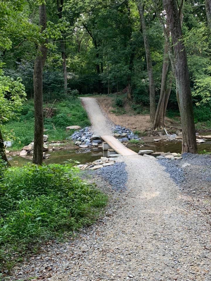
Sketchy temp bridge at MP 52
Day one, the first 20-30 miles east of Cumberland were rough with a fair amount of muddy patches. It had thunderstormed the day before and I guess they hadn't dried out yet. Nothing insurmountable. The first day was definitely the roughest section, between the mud and lots of roots and even some rocks. Jumped on the paved Western Maryland Rail Trail at Little Orleans after lunch at Bill's Place, which turned out to be a waste of time initially because in a mile or so it detours you back onto the C&O for another couple of miles due to the tunnel closure (for nesting bats).
Day two, Hancock to Harpers Ferry, was not bad, although at Williamsport we detoured off the canal trail and rode back roads over to Antietam Battlefield, rejoining the trail at the small town of Antietam. Trail was detoured west of Williamsport and we had to ride up a side trail and out on the road to get to town, but I think they just reopened the aqueduct this week and the adjacent trail, so it should be fine now. Just east of Antietam the trail was freshly resurfaced with fairly hard-packed gravel, which was really nice to ride on (see attached photo). This went just about all the way to Harpers Ferry IIRC. Be careful on this, as the shoulder slopes very abruptly on both sides and I witnessed a lady in front of me crash very hard when she caught her wheel on the edge. Very little mud on this overall section.
Day three, Harpers Ferry to DC. Very little mud on this overall section. Around Brunswick the trail shares a gravel road for a while, which was pretty rough (as @jpescatore noted). As an aside, I can't imagine why anyone would pay to camp in that Brunswick Campground, as it's adjacent to a major rail yard with train noise 24/7 it seems. Fresh gravel surface around Whites Ferry (I think to the east, but I don't 100% recall exactly). Slight detour around MP 52 to a temporary bridge due to the main bridge/culvert being out (this is noted on the NPS website).
Overall, except for the first day, the path was in very good shape. Although I could definitely see places that I'm sure would be quagmires in wet weather.
Fresh gravel surface east of Shepherdstown.
Sketchy temp bridge at MP 52
08-09-19, 12:30 PM
#22
Senior Member
Thread Starter
Does anyone know what the resurfacing plans are? It would sure be nice if they do the whole thing. As an aside, if someone else is going north to south and choose to ride the WMRT be sure to follow the signage for the C&O close to the trail as there's no way to get back on the towpath at the end of the WMRT. We almost blew by it but fortunately did not.
08-12-19, 06:42 AM
#23
Senior Member
According to the C&O Canal Association (a great organization to support if you use the Towpath a lot - join here) there will be another 18 miles of the Towpath resurfaced in 2020, they are doing 17 miles in 2019 and they did 32 since 2017 before that. A lot has just been repairing flooding damage, vs. general improvement - given the increase in heavy rain events we see now, that trend will likely continue.
When you look at all the funding cuts to the National Park System, seeing them stay even in maintenance is a huge achievement, but the C&O as a national park has always benefited from a high level of volunteer support.
When you look at all the funding cuts to the National Park System, seeing them stay even in maintenance is a huge achievement, but the C&O as a national park has always benefited from a high level of volunteer support.
08-19-19, 01:16 PM
#24
Senior Member

I’ll be riding the uphill direction over Labor Day weekend. The section downstream of Harper’s Ferry was always bad, so it’s good to hear it has been addressed. Long term forecast looks good, although unreliable this far in advance.
08-19-19, 01:19 PM
#25
Senior Member
According to the C&O Canal Association (a great organization to support if you use the Towpath a lot - join here) there will be another 18 miles of the Towpath resurfaced in 2020, they are doing 17 miles in 2019 and they did 32 since 2017 before that. A lot has just been repairing flooding damage, vs. general improvement - given the increase in heavy rain events we see now, that trend will likely continue.
When you look at all the funding cuts to the National Park System, seeing them stay even in maintenance is a huge achievement, but the C&O as a national park has always benefited from a high level of volunteer support.
When you look at all the funding cuts to the National Park System, seeing them stay even in maintenance is a huge achievement, but the C&O as a national park has always benefited from a high level of volunteer support.


