


Best route from Torrey Pines to downtown SD?
 01-29-18, 09:45 PM
#1
Senior Member
Thread Starter
Join Date: Aug 2012
Posts: 209
Mentioned: 1 Post(s)
Tagged: 0 Thread(s)
Quoted: 26 Post(s)
Likes: 0
Liked 12 Times
in
8 Posts
Best route from Torrey Pines to downtown SD?
What's the most bike friendly route to the San Diego train station? I've done the Amtrak Century, and there were a few miles of pretty crowded roads without bike lanes prior to getting near the airport, where bike lanes started again. Going to be solo or in a very small group.
 01-29-18, 11:37 PM
#2
Senior Member

Join Date: Oct 2015
Location: San Diego, California
Posts: 4,077
Bikes: Velo Orange Piolet
Mentioned: 28 Post(s)
Tagged: 0 Thread(s)
Quoted: 2228 Post(s)
Liked 2,011 Times
in
972 Posts
You need to go to the downtown (Sante Fe Depot) station? You know there's a Sorrento Valley station much closer to Torrey Pines.
If you need to go to the downtown station, see if this works for you:
If you need to go to the downtown station, see if this works for you:
Last edited by tyrion; 01-29-18 at 11:41 PM.
01-30-18, 05:34 AM
#3
velo-dilettante
Join Date: Apr 2009
Location: insane diego, california
Posts: 8,316
Bikes: 85 pinarello treviso steel, 88 nishiki olympic steel. 95 look kg 131 carbon, 11 trek madone 5.2 carbon
Mentioned: 26 Post(s)
Tagged: 0 Thread(s)
Quoted: 1628 Post(s)
Liked 3,114 Times
in
1,683 Posts
ooga128216915's Profile
this route roughly parallels the 5 freeway for most of the 15 downhill/flattish miles.
the dedicated bike path that starts/ends on gilman dr. just east of the 5 freeway has been shifted
(due to light rail expansion construction) and currently on the shoulder of the northbound freeway lanes
for about .75 of a mile (waist-high concrete barricades and chain link fence separating freeway from
path along the slightly downhill detour) before rejoining its original path.
really only two dicey spots to navigate along this route: a high speed merge just before a freeway onramp and
a slightly less high speed merge as you climb out of a little dip.
at the first stop sign you'll come to-damon street-you make a right and head under the 5 and pass an in-n-out
on your right. at the light (damon/mission bay dr), you go straight and pick up the rose canyon bike path. you'll need to dismount to access the start of the path. the path follows rose creek for about .75 mile to the edge of mission bay park. the trail itself isn't that wide, needs resurfacing, has the occasional indigent individual and has questionable sightlines here and there. if you keep your speed mostly under 18 mph or so, you should be fine. there is a low speed, low viz zigzag at the end...it's not the most direct way (that would be making a left at the damon st/mission bay dr light) and adds about a half mile but it avoids a bit of traffic and that high speed merge (behind on your right) at grand ave/mission bay drive. the high speed merge is just before the freeway entrance/about 200 yards before you make a right (avoiding entering the freeway) and follow mission bay dr as it parallels the west side of the 5.
the last big spot to watch is on pacific highway just past/south of the enterprise st/pacific hwy stop light. you descend into a smallish dip and then climb out of it with cars merging behind on your right at approx 25-35 mph from barnett rd. if you hit the dip at 25+ mph, your momentum and continued pedaling will carry you out of it and past the merge in about 10 seconds or so...or you can make a right on enterprise road at the light just before the dip and then hit midway drive. it's a funky, high volume, triangle intersection. you would need to cross over the road to the opposing sidewalk on enterprise before intersecting midway drive to hit the crosswalks (possible dismounting) that take you first across midway drive, then barnett road. once on the far side of barnett road, you pick up the bike lane that will take you thru that merge with more safety. i'd check out the intersection on google maps and use the satellite view as well to pick up the crosswalks in advance since it's a weird intersection.
there are a few other corridors you could take from torrey pines to the dtown train depot but they are either more complicated/circuitous, involve too many miles, have potentially worse "dicey" spots (imho) or any combo of the three.
morena, ingraham, nimitz, harbor dr, torrey pines rd/la jolla/blvd/mission dr i'm looking at you.
this is all assuming you can't/don't want to ride the coast highway north to pick up the train in sorrento valley, solana beach, carlsbad or oceanside or cut the journey south short by 4 miles by picking up the train at the old town station.
Last edited by diphthong; 01-30-18 at 06:25 AM.
07-29-18, 10:56 PM
#5
Slacker

Join Date: May 2009
Location: North Orange County, in Southern California
Posts: 1,295
Bikes: 1986 Peugeot Orient Express, 1987 Trek 560 Pro, 1983 SR Semi Pro, 2010 Motobecane Le Champion Titanium, 2011 Trek Fuel EX8
Mentioned: 0 Post(s)
Tagged: 0 Thread(s)
Quoted: 97 Post(s)
Liked 6 Times
in
4 Posts
ooga128216915's Profile
this route roughly parallels the 5 freeway for most of the 15 downhill/flattish miles.
the dedicated bike path that starts/ends on gilman dr. just east of the 5 freeway has been shifted
(due to light rail expansion construction) and currently on the shoulder of the northbound freeway lanes
for about .75 of a mile (waist-high concrete barricades and chain link fence separating freeway from
path along the slightly downhill detour) before rejoining its original path.
really only two dicey spots to navigate along this route: a high speed merge just before a freeway onramp and
a slightly less high speed merge as you climb out of a little dip.
at the first stop sign you'll come to-damon street-you make a right and head under the 5 and pass an in-n-out
on your right. at the light (damon/mission bay dr), you go straight and pick up the rose canyon bike path. you'll need to dismount to access the start of the path. the path follows rose creek for about .75 mile to the edge of mission bay park. the trail itself isn't that wide, needs resurfacing, has the occasional indigent individual and has questionable sightlines here and there. if you keep your speed mostly under 18 mph or so, you should be fine. there is a low speed, low viz zigzag at the end...it's not the most direct way (that would be making a left at the damon st/mission bay dr light) and adds about a half mile but it avoids a bit of traffic and that high speed merge (behind on your right) at grand ave/mission bay drive. the high speed merge is just before the freeway entrance/about 200 yards before you make a right (avoiding entering the freeway) and follow mission bay dr as it parallels the west side of the 5.
the last big spot to watch is on pacific highway just past/south of the enterprise st/pacific hwy stop light. you descend into a smallish dip and then climb out of it with cars merging behind on your right at approx 25-35 mph from barnett rd. if you hit the dip at 25+ mph, your momentum and continued pedaling will carry you out of it and past the merge in about 10 seconds or so...or you can make a right on enterprise road at the light just before the dip and then hit midway drive. it's a funky, high volume, triangle intersection. you would need to cross over the road to the opposing sidewalk on enterprise before intersecting midway drive to hit the crosswalks (possible dismounting) that take you first across midway drive, then barnett road. once on the far side of barnett road, you pick up the bike lane that will take you thru that merge with more safety. i'd check out the intersection on google maps and use the satellite view as well to pick up the crosswalks in advance since it's a weird intersection.
there are a few other corridors you could take from torrey pines to the dtown train depot but they are either more complicated/circuitous, involve too many miles, have potentially worse "dicey" spots (imho) or any combo of the three.
morena, ingraham, nimitz, harbor dr, torrey pines rd/la jolla/blvd/mission dr i'm looking at you.
this is all assuming you can't/don't want to ride the coast highway north to pick up the train in sorrento valley, solana beach, carlsbad or oceanside or cut the journey south short by 4 miles by picking up the train at the old town station.
this route roughly parallels the 5 freeway for most of the 15 downhill/flattish miles.
the dedicated bike path that starts/ends on gilman dr. just east of the 5 freeway has been shifted
(due to light rail expansion construction) and currently on the shoulder of the northbound freeway lanes
for about .75 of a mile (waist-high concrete barricades and chain link fence separating freeway from
path along the slightly downhill detour) before rejoining its original path.
really only two dicey spots to navigate along this route: a high speed merge just before a freeway onramp and
a slightly less high speed merge as you climb out of a little dip.
at the first stop sign you'll come to-damon street-you make a right and head under the 5 and pass an in-n-out
on your right. at the light (damon/mission bay dr), you go straight and pick up the rose canyon bike path. you'll need to dismount to access the start of the path. the path follows rose creek for about .75 mile to the edge of mission bay park. the trail itself isn't that wide, needs resurfacing, has the occasional indigent individual and has questionable sightlines here and there. if you keep your speed mostly under 18 mph or so, you should be fine. there is a low speed, low viz zigzag at the end...it's not the most direct way (that would be making a left at the damon st/mission bay dr light) and adds about a half mile but it avoids a bit of traffic and that high speed merge (behind on your right) at grand ave/mission bay drive. the high speed merge is just before the freeway entrance/about 200 yards before you make a right (avoiding entering the freeway) and follow mission bay dr as it parallels the west side of the 5.
the last big spot to watch is on pacific highway just past/south of the enterprise st/pacific hwy stop light. you descend into a smallish dip and then climb out of it with cars merging behind on your right at approx 25-35 mph from barnett rd. if you hit the dip at 25+ mph, your momentum and continued pedaling will carry you out of it and past the merge in about 10 seconds or so...or you can make a right on enterprise road at the light just before the dip and then hit midway drive. it's a funky, high volume, triangle intersection. you would need to cross over the road to the opposing sidewalk on enterprise before intersecting midway drive to hit the crosswalks (possible dismounting) that take you first across midway drive, then barnett road. once on the far side of barnett road, you pick up the bike lane that will take you thru that merge with more safety. i'd check out the intersection on google maps and use the satellite view as well to pick up the crosswalks in advance since it's a weird intersection.
there are a few other corridors you could take from torrey pines to the dtown train depot but they are either more complicated/circuitous, involve too many miles, have potentially worse "dicey" spots (imho) or any combo of the three.
morena, ingraham, nimitz, harbor dr, torrey pines rd/la jolla/blvd/mission dr i'm looking at you.
this is all assuming you can't/don't want to ride the coast highway north to pick up the train in sorrento valley, solana beach, carlsbad or oceanside or cut the journey south short by 4 miles by picking up the train at the old town station.
07-30-18, 02:50 AM
#6
velo-dilettante
Join Date: Apr 2009
Location: insane diego, california
Posts: 8,316
Bikes: 85 pinarello treviso steel, 88 nishiki olympic steel. 95 look kg 131 carbon, 11 trek madone 5.2 carbon
Mentioned: 26 Post(s)
Tagged: 0 Thread(s)
Quoted: 1628 Post(s)
Liked 3,114 Times
in
1,683 Posts
no newish problems. the existing ones covered in post #3 still exist. those looking for a dedicated bike path from point a to b will be sorely disappointed.
those looking for a reasonable (in socal) route and are semi/relatively experienced in riding with auto traffic should be just fine.
those looking for a reasonable (in socal) route and are semi/relatively experienced in riding with auto traffic should be just fine.
08-01-18, 10:21 AM
#7
Senior Member

Join Date: Mar 2006
Location: Carlsbad CA and Studio City CA
Posts: 176
Bikes: Bacchetta Giro 26, Brompton
Mentioned: 2 Post(s)
Tagged: 0 Thread(s)
Quoted: 67 Post(s)
Likes: 0
Liked 2 Times
in
1 Post
You need to go to the downtown (Sante Fe Depot) station? You know there's a Sorrento Valley station much closer to Torrey Pines.
If you need to go to the downtown station, see if this works for you:
https://www.google.com/maps/dir/32.8...32.7167185!3e1
If you need to go to the downtown station, see if this works for you:
https://www.google.com/maps/dir/32.8...32.7167185!3e1
08-01-18, 10:35 AM
#8
Senior Member
Join Date: Oct 2015
Location: San Diego, California
Posts: 4,077
Bikes: Velo Orange Piolet
Mentioned: 28 Post(s)
Tagged: 0 Thread(s)
Quoted: 2228 Post(s)
Liked 2,011 Times
in
972 Posts
Google Street View is showing the detour of the Rose Canyon bike path in their 3/2018 images. Would you be able to advise regarding any other problems with this route? It has been years since I rode this.
(The Rose Creek path is a major bike commuter route so they work hard to keep it open.)
08-02-18, 04:19 PM
#10

got the climbing bug

Join Date: Jan 2005
Location: San Diego
Posts: 10,206
Bikes: one for everything
Mentioned: 82 Post(s)
Tagged: 0 Thread(s)
Quoted: 632 Post(s)
Liked 913 Times
in
275 Posts
I usually take this route to Point loma or Downtown via LaJolla and Mission Bay. Gets a lil skinny as you get into PB so own the road when you can. Watch for cross foot traffic and pot holes.
https://ridewithgps.com/routes/28239679
Here is the more direct route, less stuff to look at
https://ridewithgps.com/routes/28239699
https://ridewithgps.com/routes/28239679
Here is the more direct route, less stuff to look at
https://ridewithgps.com/routes/28239699
__________________
Rule #10 // It never gets easier, you just go faster.
Rule #10 // It never gets easier, you just go faster.
08-02-18, 09:02 PM
#11
Slacker
Join Date: May 2009
Location: North Orange County, in Southern California
Posts: 1,295
Bikes: 1986 Peugeot Orient Express, 1987 Trek 560 Pro, 1983 SR Semi Pro, 2010 Motobecane Le Champion Titanium, 2011 Trek Fuel EX8
Mentioned: 0 Post(s)
Tagged: 0 Thread(s)
Quoted: 97 Post(s)
Liked 6 Times
in
4 Posts
I usually take this route to Point loma or Downtown via LaJolla and Mission Bay. Gets a lil skinny as you get into PB so own the road when you can. Watch for cross foot traffic and pot holes.
https://ridewithgps.com/routes/28239679
Here is the more direct route, less stuff to look at
https://ridewithgps.com/routes/28239699
https://ridewithgps.com/routes/28239679
Here is the more direct route, less stuff to look at
https://ridewithgps.com/routes/28239699
I'll have to practice navigating with my Edge 510. Prior attempts have been unsatisfactory. But my memory ain't what it used to be, and I can look at a map on my phone when I'm out on the bike, but even if I navigate by vectors, it's hard to remember more than a handful of turns. I have to get that Garmin Edge working for me.
By the way, I appreciate that Strava trick you showed us on a different thread, which I passed on to a friend that is about to attempt riding from Maine to home (in Orange County). That's a slick way to capture each day as you did.
08-03-18, 03:58 PM
#12
got the climbing bug
Join Date: Jan 2005
Location: San Diego
Posts: 10,206
Bikes: one for everything
Mentioned: 82 Post(s)
Tagged: 0 Thread(s)
Quoted: 632 Post(s)
Liked 913 Times
in
275 Posts
If you go down the coast line like in my first route, when you see the roller coaster, go Left at that light. Ride over the 1st bridge. Than turn right at the next light into what looks like a park/harbor. Go Left at the TEE (goes in a loop) about 1/2 mile down you will see the bike trail on Left side of the road. Looks like a sidewalk that goes up a hill. Nimitz is on the other side of that bridge that the bike trail leads you on. This is also the same trail that is on my 2nd link so if you ride back and want more direct way to UTC/Torrey Pines area.
Also once in PB, instead of stay on the road, there is a bike trail next to the sand that is SUPER packed with other people. This is an optional bypass to the crappy potholed streets in the area. It's like sub 10mph EASY with hands on the brakes and one foot not clipped in HAHA.
Also once in PB, instead of stay on the road, there is a bike trail next to the sand that is SUPER packed with other people. This is an optional bypass to the crappy potholed streets in the area. It's like sub 10mph EASY with hands on the brakes and one foot not clipped in HAHA.
__________________
Rule #10 // It never gets easier, you just go faster.
Rule #10 // It never gets easier, you just go faster.
08-03-18, 08:41 PM
#13
Slacker
Join Date: May 2009
Location: North Orange County, in Southern California
Posts: 1,295
Bikes: 1986 Peugeot Orient Express, 1987 Trek 560 Pro, 1983 SR Semi Pro, 2010 Motobecane Le Champion Titanium, 2011 Trek Fuel EX8
Mentioned: 0 Post(s)
Tagged: 0 Thread(s)
Quoted: 97 Post(s)
Liked 6 Times
in
4 Posts
If you go down the coast line like in my first route, when you see the roller coaster, go Left at that light. Ride over the 1st bridge. Than turn right at the next light into what looks like a park/harbor. Go Left at the TEE (goes in a loop) about 1/2 mile down you will see the bike trail on Left side of the road. Looks like a sidewalk that goes up a hill. Nimitz is on the other side of that bridge that the bike trail leads you on. This is also the same trail that is on my 2nd link so if you ride back and want more direct way to UTC/Torrey Pines area.
Also once in PB, instead of stay on the road, there is a bike trail next to the sand that is SUPER packed with other people. This is an optional bypass to the crappy potholed streets in the area. It's like sub 10mph EASY with hands on the brakes and one foot not clipped in HAHA.
Also once in PB, instead of stay on the road, there is a bike trail next to the sand that is SUPER packed with other people. This is an optional bypass to the crappy potholed streets in the area. It's like sub 10mph EASY with hands on the brakes and one foot not clipped in HAHA.
The other trail is the "Spanish Landing Trail" along the shore across from Harbor Island? I zoomed in and looked closely at the maps with the satellite overlay.
If everything goes as planned, I'll use your route as part of an Anaheim --> San Diego century in October. With any luck we'll be riding on a weekday, so maybe the bike trails won't be so awful. We're going to train it back, so all we need to do is get to SAN in time for our train.
08-08-18, 11:08 AM
#14
Newbie
Join Date: Aug 2017
Location: San Diego, CA
Posts: 3
Bikes: 2017 Brompton M6R, 1991 Trek 1200, 1982 Nishiki Olympic 12 mixte, 1969-ish Phillips
Mentioned: 0 Post(s)
Tagged: 0 Thread(s)
Quoted: 4 Post(s)
Likes: 0
Liked 0 Times
in
0 Posts
If everything goes as planned, I'll use your route as part of an Anaheim --> San Diego century in October. With any luck we'll be riding on a weekday, so maybe the bike trails won't be so awful. We're going to train it back, so all we need to do is get to SAN in time for our train.
Torrey Pines Rd. around UCSD is standard Class II bike lane, but Torrey Pines Rd heading from UCSD into La Jolla Cove is a nightmare downhill and uphill with a ton of fast traffic and not very much bike protection. As much as I love the ride from the Cove to downtown, I can't recommend it if you're not comfortable riding in heavy fast traffic.
If you ride on the Ocean Beach bike path to Nimitz Blvd, note that there are a couple of really scary high speed/traffic volume intersections. If I'm going that way I will often ride further west on the OB Bike Path and through Ocean Beach via Voltaire and Wabaska to get on to Nimitz; let me know if you need me to map that out.
Also, check the NCTD Service Alerts page for rail closures. They are scheduled for October 13-14 and 20-21. All trains are cancelled including Amtrak and no bikes are allowed on Amtrak buses.
Unfortunately I can't post links to the LOSSAN schedule, NCTD Service Alerts, and the Pacific Surfliner schedule as I don't have ten posts yet; hopefully they're easy to find.
08-10-18, 02:24 PM
#15
Slacker
Join Date: May 2009
Location: North Orange County, in Southern California
Posts: 1,295
Bikes: 1986 Peugeot Orient Express, 1987 Trek 560 Pro, 1983 SR Semi Pro, 2010 Motobecane Le Champion Titanium, 2011 Trek Fuel EX8
Mentioned: 0 Post(s)
Tagged: 0 Thread(s)
Quoted: 97 Post(s)
Liked 6 Times
in
4 Posts
I use Tyrion's Google-maps marked way except I'll stay west of I-5 around Mission Bay and use the Rose Creek Bike Path and Mission Bay Drive as Ooga-Booga describes. This way also keeps you relatively close to Old Town in case you need to bail and take Amtrak from there. The LOSSAN Joint schedule is immensely helpful as a planning tool. Note that some Amtrak trains do stop at Old Town and/or Sorrento Valley; check the LOSSAN schedule above or the Pacific Surfliner schedule for the full detail.
Torrey Pines Rd. around UCSD is standard Class II bike lane, but Torrey Pines Rd heading from UCSD into La Jolla Cove is a nightmare downhill and uphill with a ton of fast traffic and not very much bike protection. As much as I love the ride from the Cove to downtown, I can't recommend it if you're not comfortable riding in heavy fast traffic.
If you ride on the Ocean Beach bike path to Nimitz Blvd, note that there are a couple of really scary high speed/traffic volume intersections. If I'm going that way I will often ride further west on the OB Bike Path and through Ocean Beach via Voltaire and Wabaska to get on to Nimitz; let me know if you need me to map that out.
Also, check the NCTD Service Alerts page for rail closures. They are scheduled for October 13-14 and 20-21. All trains are cancelled including Amtrak and no bikes are allowed on Amtrak buses.
Unfortunately I can't post links to the LOSSAN schedule, NCTD Service Alerts, and the Pacific Surfliner schedule as I don't have ten posts yet; hopefully they're easy to find.
In the past I have seen Amtrak bus drivers put bikes into the luggage bay of a Thruway bus even after being told "no bikes on this bus," and there is frequently a difference between what is said and what is done so far as Amtrak is concerned.
We're planning to do the ride on a weekday, if we go. Have to see if everyone gets their Pendleton IDs first.
Regarding the route posted by @jsigone thru La Jolla, how would you expect it to be on a Friday afternoon around 2:00 p.m.?
08-10-18, 02:50 PM
#16
Newbie
Join Date: Aug 2017
Location: San Diego, CA
Posts: 3
Bikes: 2017 Brompton M6R, 1991 Trek 1200, 1982 Nishiki Olympic 12 mixte, 1969-ish Phillips
Mentioned: 0 Post(s)
Tagged: 0 Thread(s)
Quoted: 4 Post(s)
Likes: 0
Liked 0 Times
in
0 Posts
Adding: Completely empathize with you on Amtrak but I can't assume everyone here follows Twitter and it sounded like a weekend ride was still a possibility. They are consistent in their inconsistency and have a tendency of putting out a Service Alert only at the last possible moment.
Last edited by allanorn; 08-10-18 at 02:54 PM. Reason: Amtrak
08-10-18, 05:59 PM
#17
Slacker
Join Date: May 2009
Location: North Orange County, in Southern California
Posts: 1,295
Bikes: 1986 Peugeot Orient Express, 1987 Trek 560 Pro, 1983 SR Semi Pro, 2010 Motobecane Le Champion Titanium, 2011 Trek Fuel EX8
Mentioned: 0 Post(s)
Tagged: 0 Thread(s)
Quoted: 97 Post(s)
Liked 6 Times
in
4 Posts
I forgot to mention, one of my cycling friends was doored on that route recommended by @jsigone. It was some time ago, however, but when I looked at it on street view I could see, very possible. I hope we will be 5-6 riders, total, so hopefully safety in numbers.
08-11-18, 02:38 AM
#18
velo-dilettante
Join Date: Apr 2009
Location: insane diego, california
Posts: 8,316
Bikes: 85 pinarello treviso steel, 88 nishiki olympic steel. 95 look kg 131 carbon, 11 trek madone 5.2 carbon
Mentioned: 26 Post(s)
Tagged: 0 Thread(s)
Quoted: 1628 Post(s)
Liked 3,114 Times
in
1,683 Posts
Friday at 2pm should be okay as it's not the start of rush hour, but Torrey Pines Rd. to the cove can have heavy traffic. Getting onto Nimitz from the bike path is usually a challenge and nobody's paying attention to cyclists there, which is why I suggested the alternative by going west on the OB Bike Path towards Dog Beach from the intersection of I-8 and Sunset Cliffs and going via Bacon-Voltaire-Wabaska to reach Nimitz.
Adding: Completely empathize with you on Amtrak but I can't assume everyone here follows Twitter and it sounded like a weekend ride was still a possibility. They are consistent in their inconsistency and have a tendency of putting out a Service Alert only at the last possible moment.
Adding: Completely empathize with you on Amtrak but I can't assume everyone here follows Twitter and it sounded like a weekend ride was still a possibility. They are consistent in their inconsistency and have a tendency of putting out a Service Alert only at the last possible moment.
the woofers on leashes, the woofers off leashes and the oblivious/enraptured/stoned/drunk humanoids, be on guard. you've been warned.
08-13-18, 11:34 AM
#19
got the climbing bug
Join Date: Jan 2005
Location: San Diego
Posts: 10,206
Bikes: one for everything
Mentioned: 82 Post(s)
Tagged: 0 Thread(s)
Quoted: 632 Post(s)
Liked 913 Times
in
275 Posts
I try to ride my bike to visit my brother's grave at Cabrillo National Monument once a month. I usually start from Escondido or Rancho Bernardo. I've never had issues going along the beach route on prime Saturday morning/afternoons. Mind you I'm only on Nimitz for a mile and make a right turn up Catalina road that goes to the point. Mellow 2-3% grade hill for a few minutes. Once you get to Pete's coffee you can go left down the hill to Shelter Island/Harbor Drive. This would bypass the skinny part of Nimitz that has a green painted bike lane.
The only issues I had are the horible roads in PB and everyone j walking. Take the lane cuz you CAN, and look everywhere while hauling butt to get through it faster.
If you have extra credit in your legs, go up the northside of Mt Soledad and feel those awesome 10-18% grades/driveways. Come down the front side (south side) WAYYY batter pavement for going 30-45mph.
edit:
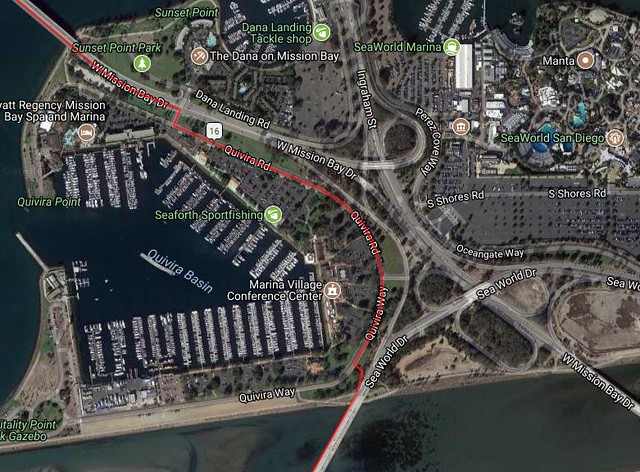
This is the is the Side road to take in Mission Bay that goes along the almost zero traffic Harbor Marina straight to the bike trail, over the bridge to the Nimitz stop light where the Skate park is. I stayed on the road once and won't do it again after I found this.
The only issues I had are the horible roads in PB and everyone j walking. Take the lane cuz you CAN, and look everywhere while hauling butt to get through it faster.
If you have extra credit in your legs, go up the northside of Mt Soledad and feel those awesome 10-18% grades/driveways. Come down the front side (south side) WAYYY batter pavement for going 30-45mph.
edit:
This is the is the Side road to take in Mission Bay that goes along the almost zero traffic Harbor Marina straight to the bike trail, over the bridge to the Nimitz stop light where the Skate park is. I stayed on the road once and won't do it again after I found this.
__________________
Rule #10 // It never gets easier, you just go faster.
Rule #10 // It never gets easier, you just go faster.
Last edited by jsigone; 08-13-18 at 11:41 AM.

Thread
Thread Starter
Forum
Replies
Last Post
CommuteCommando
Southern California
6
06-03-12 09:09 PM
speedemon
Northern California
7
10-05-10 11:24 PM
