


Cue Sheets
 09-30-23, 03:44 PM
#26

Standard Member
Join Date: Apr 2009
Location: Brunswick, Maine
Posts: 4,272
Bikes: 1948 P. Barnard & Son, 1962 Rudge Sports, 1963 Freddie Grubb Routier, 1980 Manufrance Hirondelle, 1983 F. Moser Sprint, 1989 Raleigh Technium Pre, 2001 Raleigh M80
Mentioned: 26 Post(s)
Tagged: 0 Thread(s)
Quoted: 1297 Post(s)
Liked 940 Times
in
490 Posts
I'm a big fan of cue sheets. A gps is fine, but if you don't know the course, a backup cue sheet is really good to have. Also, if you don't know the course, following along on a map ahead of time is a really good idea. Ride with gps makes pretty good cue sheets now, although I still think it can fail to generate a cue under certain circumstances.
__________________
Unless you climb the rungs strategically, you�re not going to build the muscle you need to stay at the top.
Unless you climb the rungs strategically, you�re not going to build the muscle you need to stay at the top.
 09-30-23, 04:53 PM
#27
Senior Member
Join Date: Jan 2010
Posts: 39,249
Mentioned: 211 Post(s)
Tagged: 1 Thread(s)
Quoted: 18421 Post(s)
Liked 15,569 Times
in
7,335 Posts

Seriously�I map on RWGPS and type paper cue sheets. Helps me internalize the route.
On rare occasions, I will make a mistake, like indicating a left rather than a right. While on tour in 2017 I ran into a couple in Wallace, ID who had done poor planning and only had a high level map. One of my cue sheets was helpful to them, so I gave it to them. (I had extras.) Before I did, I noticed a mistake and corrected it with a pen. I think that made them wary.
 Sometimes wonder if they made it to Glacier N.P.
Likes For indyfabz:
09-30-23, 06:56 PM
#28
just another gosling
Join Date: Feb 2007
Location: Everett, WA
Posts: 19,535
Bikes: CoMo Speedster 2003, Trek 5200, CAAD 9, Fred 2004
Mentioned: 115 Post(s)
Tagged: 0 Thread(s)
Quoted: 3889 Post(s)
Liked 1,938 Times
in
1,383 Posts
Please post a link to your MySpace page.
Seriously�I map on RWGPS and type paper cue sheets. Helps me internalize the route.
On rare occasions, I will make a mistake, like indicating a left rather than a right. While on tour in 2017 I ran into a couple in Wallace, ID who had done poor planning and only had a high level map. One of my cue sheets was helpful to them, so I gave it to them. (I had extras.) Before I did, I noticed a mistake and corrected it with a pen. I think that made them wary. Sometimes wonder if they made it to Glacier N.P.
Seriously�I map on RWGPS and type paper cue sheets. Helps me internalize the route.
On rare occasions, I will make a mistake, like indicating a left rather than a right. While on tour in 2017 I ran into a couple in Wallace, ID who had done poor planning and only had a high level map. One of my cue sheets was helpful to them, so I gave it to them. (I had extras.) Before I did, I noticed a mistake and corrected it with a pen. I think that made them wary.
Sometimes wonder if they made it to Glacier N.P.After creating or before using someone else's route, I run the RWGPS Review Cues tool on it. I can never believe how many errors people make on their RWGPS routes - which can totally mess you up if you're using a device. I think the commonest error is viewing the route too zoomed out and putting control points off to one side, thus creating extra false cues. I never use a route I haven't corrected.
__________________
Results matter
Results matter
09-30-23, 07:40 PM
#29
Senior Member
Join Date: Sep 2005
Location: In the foothills of Los Angeles County
Posts: 25,298
Mentioned: 8 Post(s)
Tagged: 0 Thread(s)
Quoted: 8283 Post(s)
Liked 9,053 Times
in
4,479 Posts
Both road clubs I ride with have cue sheets on their web pages. If you want one you can print it from there.
When I joined the main club in 1989 the club printed and kept paper files of all the route slips, or cue sheets. One guy had a room dedicated to these things and if there were 4 rides on the schedule he would take 4 stacks of the sheets to the ride start and pick up the unused ones after everyone had left, or after the ride if he was riding.
The old guard in the club fought against putting the routes on-line but eventually gave in. They also put the newsletter and other club stuff on the web. We used to collate and staple the newsletter at club monthly meetings.
10-01-23, 05:37 AM
#31
Standard Member
Join Date: Apr 2009
Location: Brunswick, Maine
Posts: 4,272
Bikes: 1948 P. Barnard & Son, 1962 Rudge Sports, 1963 Freddie Grubb Routier, 1980 Manufrance Hirondelle, 1983 F. Moser Sprint, 1989 Raleigh Technium Pre, 2001 Raleigh M80
Mentioned: 26 Post(s)
Tagged: 0 Thread(s)
Quoted: 1297 Post(s)
Liked 940 Times
in
490 Posts
No, I do not carry a phone. As you may know, non-ionizing radiation levels must far-exceed those produced by a cell phone to actually break cell walls (creating conditions for cancer), but close-proximity to these devices does upset mitochondrial activity. This can lead to similar conditions. This is why I am wary of them.
From Energy Theory website:
If you use them daily for less than six hours, they are comparable to cell phones and should not be seen as a problem. Garmin equipment can lead to the absorption of non-ionizing and RF radiation by the skin because they are worn close to it.
__________________
Unless you climb the rungs strategically, you�re not going to build the muscle you need to stay at the top.
Unless you climb the rungs strategically, you�re not going to build the muscle you need to stay at the top.
Last edited by 1989Pre; 10-01-23 at 05:58 AM.
10-01-23, 05:56 AM
#32
Standard Member
Join Date: Apr 2009
Location: Brunswick, Maine
Posts: 4,272
Bikes: 1948 P. Barnard & Son, 1962 Rudge Sports, 1963 Freddie Grubb Routier, 1980 Manufrance Hirondelle, 1983 F. Moser Sprint, 1989 Raleigh Technium Pre, 2001 Raleigh M80
Mentioned: 26 Post(s)
Tagged: 0 Thread(s)
Quoted: 1297 Post(s)
Liked 940 Times
in
490 Posts
Exactly. It is this internalization that I have found to be effective. You use an impact type-writer? I thought I was the only one who still used one (only for formal communications, though). In other news, I don't use My Space (or ICQ) anymore. Sorry to dis-appoint.
__________________
Unless you climb the rungs strategically, you�re not going to build the muscle you need to stay at the top.
Unless you climb the rungs strategically, you�re not going to build the muscle you need to stay at the top.
10-01-23, 05:57 AM
#33
Senior Member
Join Date: Sep 2007
Location: Far beyond the pale horizon.
Posts: 14,278
Mentioned: 31 Post(s)
Tagged: 0 Thread(s)
Quoted: 4260 Post(s)
Liked 1,363 Times
in
945 Posts
It seems to me that the unit (on the handlebars) would always be receiving a signal, and that when I am down in the drops, my body would be in contact with the unit, over the heart or thymus area. Maybe I am wrong about that. From what you are saying, it may be that the unit must be turned on before any sort of transmission occurs. Can you confirm? If so, thank you for the correction.
The devices can transmit radiation (they’d be a source in that case) but it would be at very low power since it’s not transmitting very far (a few feet). Cellphones are transmitting much longer distances. The Garmins try to conserve power, which means they’d minimize how often they’d transmit. Cellphones, when they are not being used, will also try to minimize transmission.
(Note that I have no interest in having you change whatever you choose to do or not do. The “mitochondria” thing sounds like something being promoted by Mercola.)
Last edited by njkayaker; 10-01-23 at 06:02 AM.
10-01-23, 06:09 AM
#34
Senior Member
Depends upon your ride & how much info you need. I used both RWGPS and self generated cue sheets on a coast to coast race. The cue sheet served as both backup navigation and to identify services, gaps in services and warnings to stock up on food and water. Also various sights along the way. Served me well.

10-01-23, 06:18 AM
#35
Standard Member
Join Date: Apr 2009
Location: Brunswick, Maine
Posts: 4,272
Bikes: 1948 P. Barnard & Son, 1962 Rudge Sports, 1963 Freddie Grubb Routier, 1980 Manufrance Hirondelle, 1983 F. Moser Sprint, 1989 Raleigh Technium Pre, 2001 Raleigh M80
Mentioned: 26 Post(s)
Tagged: 0 Thread(s)
Quoted: 1297 Post(s)
Liked 940 Times
in
490 Posts
njkayaker, well.., when I reach for my cue sheet, I don't have to wonder whether it is on airplane or bluetooth mode. Dr. Mercola has a lot of good information, but he, like several naturopaths and functional medicine doctors, somewhat squandered their reputations by vaccine denial.
__________________
Unless you climb the rungs strategically, you�re not going to build the muscle you need to stay at the top.
Unless you climb the rungs strategically, you�re not going to build the muscle you need to stay at the top.
 10-01-23, 06:35 AM
#37
Senior Member
Join Date: Sep 2007
Location: Far beyond the pale horizon.
Posts: 14,278
Mentioned: 31 Post(s)
Tagged: 0 Thread(s)
Quoted: 4260 Post(s)
Liked 1,363 Times
in
945 Posts
njkayaker, well.., when I reach for my cue sheet, I don't have to wonder whether it is on airplane or bluetooth mode. Dr. Mercola has a lot of good information, but he, like several naturopaths and functional medicine doctors, somewhat squandered their reputations by vaccine denial.
The Garmins are mostly in “airplane mode” (regarding transmission). So, there isn’t any need to wonder.
Mercola is not a reliable source of information. He might be right about some things but you should be able to get that information from people who haven’t “squandered their reputation”. In any case, his position on vaccines was expected from his prior reputation (which was bad).
Last edited by njkayaker; 10-01-23 at 06:55 AM.
10-01-23, 06:37 AM
#38
Standard Member
Join Date: Apr 2009
Location: Brunswick, Maine
Posts: 4,272
Bikes: 1948 P. Barnard & Son, 1962 Rudge Sports, 1963 Freddie Grubb Routier, 1980 Manufrance Hirondelle, 1983 F. Moser Sprint, 1989 Raleigh Technium Pre, 2001 Raleigh M80
Mentioned: 26 Post(s)
Tagged: 0 Thread(s)
Quoted: 1297 Post(s)
Liked 940 Times
in
490 Posts
Again, I�m not trying to get you to change what you are doing.
Mercola is not a reliable source of information. He might be right about some things but you should be able to get that information for people who haven�t �squandered their reputation�. In any case, his position on vaccines was expected from his prior reputation (which was bad).
Mercola is not a reliable source of information. He might be right about some things but you should be able to get that information for people who haven�t �squandered their reputation�. In any case, his position on vaccines was expected from his prior reputation (which was bad).
__________________
Unless you climb the rungs strategically, you�re not going to build the muscle you need to stay at the top.
Unless you climb the rungs strategically, you�re not going to build the muscle you need to stay at the top.
10-01-23, 06:39 AM
#39
Senior Member
Join Date: Sep 2007
Location: Far beyond the pale horizon.
Posts: 14,278
Mentioned: 31 Post(s)
Tagged: 0 Thread(s)
Quoted: 4260 Post(s)
Liked 1,363 Times
in
945 Posts
Depends upon your ride & how much info you need. I used both RWGPS and self generated cue sheets on a coast to coast race. The cue sheet served as both backup navigation and to identify services, gaps in services and warnings to stock up on food and water. Also various sights along the way. Served me well.
Cue sheets are primarily a list of turns. This other stuff is kind of secondary. That is, you can have this stuff without needing the stuff that characterizes a cue sheet.
The turn information isn’t very useful as a backup. Anybody who has the time to train or participate in a cross country race should be able to afford a backup GPS.
Last edited by njkayaker; 10-01-23 at 06:58 AM.
10-01-23, 06:48 AM
#40
Senior Member
Join Date: May 2021
Posts: 8,450
Mentioned: 12 Post(s)
Tagged: 0 Thread(s)
Quoted: 4415 Post(s)
Liked 4,867 Times
in
3,012 Posts
I�m old enough to remember using cue sheets and paper maps to navigate routes. GPS has long since made those items totally redundant for me.
10-01-23, 08:09 AM
#41
Banned
Join Date: Feb 2008
Location: Mississauga/Toronto, Ontario canada
Posts: 8,721
Bikes: I have 3 singlespeed/fixed gear bikes
Mentioned: 30 Post(s)
Tagged: 0 Thread(s)
Quoted: 4227 Post(s)
Liked 2,488 Times
in
1,286 Posts
I always enjoyed reading and studying maps and don't use GPS...If I am going into an unknown area I will study Google Maps or paper maps and sometimes take a sheet of paper and make notes, drawings and sketches of the route which I plan on taking. I find it pretty easy to memorize routes from Google Maps and after riding them once it's in my memory forever.
10-01-23, 09:14 AM
#42
climber has-been

Join Date: Dec 2004
Location: Palo Alto, CA
Posts: 7,111
Bikes: Scott Addict R1, Felt Z1
Mentioned: 10 Post(s)
Tagged: 0 Thread(s)
Quoted: 3432 Post(s)
Liked 3,567 Times
in
1,793 Posts
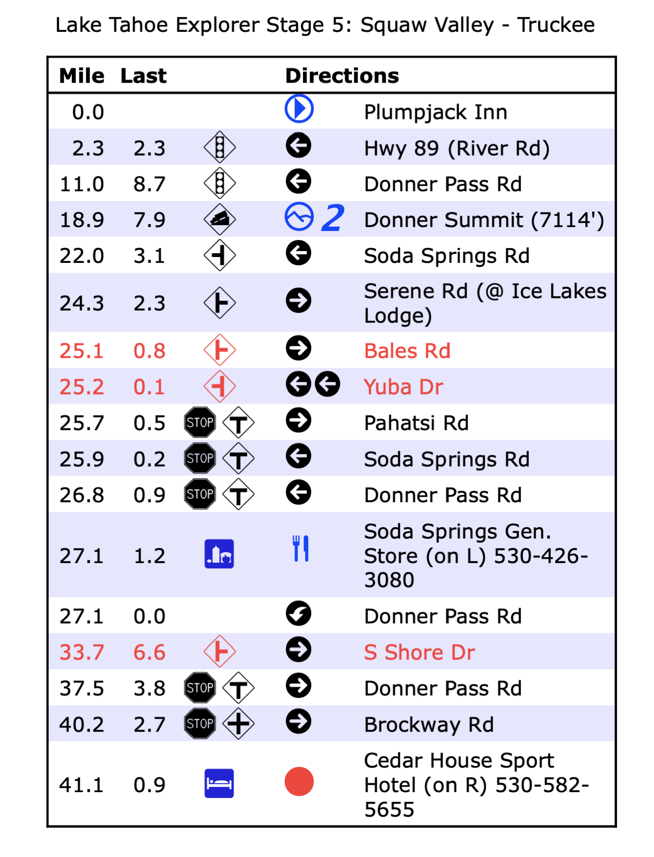
FWIW, here was the last format for route sheets I built manually for our bike tours. Before RWGPS was usable:
Following a GPS is much simpler.
Following a GPS is much simpler.
__________________
Ride, Rest, Repeat. ROUVY: terrymorse

Ride, Rest, Repeat. ROUVY: terrymorse
Likes For terrymorse:
10-02-23, 04:25 AM
#43
Senior Member
The fatal flaw of depending on cue sheets (beyond how to carry them and keep the dry, etc) is when you miss a cue and keeping hoping you will see the next cue soon... I used to copy a map page on the back of the cue sheet but on long rides the resolution was so low you could never read road names to try to get back on track.
My Wahoo, and I'm sure all GPS units these days, gives you map view, cue sheet view etc. On multi-day rides I carry paper backup but could also use my phone as backup.
I do remember downloading a special Windows font for cue sheets back in the pre-GPS days.
My Wahoo, and I'm sure all GPS units these days, gives you map view, cue sheet view etc. On multi-day rides I carry paper backup but could also use my phone as backup.
I do remember downloading a special Windows font for cue sheets back in the pre-GPS days.
10-02-23, 05:31 AM
#44
Senior Member
Join Date: Apr 2014
Location: Connecticut
Posts: 523
Bikes: Trek Domane, Surly Disc Trucker
Mentioned: 3 Post(s)
Tagged: 0 Thread(s)
Quoted: 170 Post(s)
Liked 103 Times
in
68 Posts
Interestingly, the D2R2 gravel ride - a fairly prominent gravel ride in Massachusetts/Vermont - has on their website the following:
PLEASE USE CUE SHEETS to navigate routes. Maps and GPS files are for basic reference but may have minor inconsistencies. In true Randonnee style - please use your cue sheet.
If you intend to only use a GPS to navigate the route, please at least take the time to read through the cue sheet pre-ride as it also contains important cautionary information as well as useful route divergence information.
They actually recommend using the cue sheets.
As an aside, I made up my own Google Maps/cue sheet for a ride I did yesterday. I was generally familiar with the area but wanted to do a specific loop and wasn't sure I'd recall it without the map.
Likes For dennis336:
10-02-23, 06:06 AM
#45
Senior Member
Join Date: Jan 2010
Posts: 39,249
Mentioned: 211 Post(s)
Tagged: 1 Thread(s)
Quoted: 18421 Post(s)
Liked 15,569 Times
in
7,335 Posts
Depends upon your ride & how much info you need. I used both RWGPS and self generated cue sheets on a coast to coast race. The cue sheet served as both backup navigation and to identify services, gaps in services and warnings to stock up on food and water. Also various sights along the way. Served me well.
Heh. Muddy Gap. Has to be the easiest crossing of the western Continental Divide. Haven't been there since 2000. Spent the night before in Jeffrey City and got up early to beat the wind on the way to Rawlins on July 4th. Saw several pronghorns.
Jeffrey City is a strange place with an interesting history. Talked about it with a one-legged woman at the bar in town. I see someone has revived the old JC Motel. I read a review shortly before it closed. The cycle tourist said there were mushrooms growing out of the carpet in his room. IIRC, that was late 2000s. Only motel I have ever stayed in that did not take credit cards. The old woman who took my money was on oxygen and smoking a cigarette.
10-02-23, 06:17 AM
#46
Senior Member
Join Date: Jan 2010
Posts: 39,249
Mentioned: 211 Post(s)
Tagged: 1 Thread(s)
Quoted: 18421 Post(s)
Liked 15,569 Times
in
7,335 Posts
Interestingly, the D2R2 gravel ride - a fairly prominent gravel ride in Massachusetts/Vermont - has on their website the following:
PLEASE USE CUE SHEETS to navigate routes. Maps and GPS files are for basic reference but may have minor inconsistencies. In true Randonnee style - please use your cue sheet.
If you intend to only use a GPS to navigate the route, please at least take the time to read through the cue sheet pre-ride as it also contains important cautionary information as well as useful route divergence information.
They actually recommend using the cue sheets.
Great event, BTW. I went to high school at Deerfield Academy. Four-year man. Class of '83. I have stopped by the campus a few times during tours from VT home to Philly. The juxtaposition of the luxury (e.g., relatively new, $82 million athletic complex with indoor hockey rink) and nearby Greenfield, which supposedly has the highest rate of opioid addiction in MA, is striking.
10-02-23, 07:01 AM
#47
Senior Member
Join Date: Apr 2014
Location: Connecticut
Posts: 523
Bikes: Trek Domane, Surly Disc Trucker
Mentioned: 3 Post(s)
Tagged: 0 Thread(s)
Quoted: 170 Post(s)
Liked 103 Times
in
68 Posts
I have done that event twice. I can understand why. Despite being in MA and VT, it uses some pretty remote roads. Some are old carriage roads still paved with cobbles. Might not be accurately captured on GPS or even maps.
Great event, BTW. I went to high school at Deerfield Academy. Four-year man. Class of '83. I have stopped by the campus a few times during tours from VT home to Philly. The juxtaposition of the luxury (e.g., relatively new, $82 million athletic complex with indoor hockey rink) and nearby Greenfield, which supposedly has the highest rate of opioid addiction in MA, is striking.
Great event, BTW. I went to high school at Deerfield Academy. Four-year man. Class of '83. I have stopped by the campus a few times during tours from VT home to Philly. The juxtaposition of the luxury (e.g., relatively new, $82 million athletic complex with indoor hockey rink) and nearby Greenfield, which supposedly has the highest rate of opioid addiction in MA, is striking.
But, yeah, a beautiful area albeit relentlessly hilly. I can survive fairly long climbs if the grade is moderate but I don't have many of those steep gravel climbs left in these 70 year old legs!
(Didn't realize that about Greenfield - really sad. CT has also had very high drug/opiod overdose deaths).
Last edited by dennis336; 10-02-23 at 07:04 AM.
10-02-23, 07:51 AM
#48
Senior Member
Join Date: Sep 2007
Location: Far beyond the pale horizon.
Posts: 14,278
Mentioned: 31 Post(s)
Tagged: 0 Thread(s)
Quoted: 4260 Post(s)
Liked 1,363 Times
in
945 Posts
With or without GPS?
You don’t need maps to use a GPS if you have a track. The road conditions seems irrelevant. The maps don’t have to be very accurate either.
If they can create a cue sheet, they can update the Openstreetmap map. If they are riding the route to verify the cue sheet, they can get a track.
If the ride is basically the same course every year, there is even less reason not to update the maps.
This ride could be one where supplemental information is more necessary than usual.
A major problem with cue sheets (being not very useful if you go off them) would likely be much more of a problem on this sort of ride.
They provide GPS routes on RWGPS. The cue sheets are in RWGPS (with extensive updates).
https://www.franklinlandtrust.org/d2r2-routes/
All of the 180k is on roads that are on the map (Google and OSM).
This seems partly motivated by “tradition”. It also may partly be a CYA thing because the cue sheets might have warnings that they don’t want people to not read.
I don’t think this ends up being any argument that “cue sheets are better”.
The real question is how many of the riders use GPS. I bet it’s most of them. The organizers probably realize that.
If they can create a cue sheet, they can update the Openstreetmap map. If they are riding the route to verify the cue sheet, they can get a track.
If the ride is basically the same course every year, there is even less reason not to update the maps.
This ride could be one where supplemental information is more necessary than usual.
A major problem with cue sheets (being not very useful if you go off them) would likely be much more of a problem on this sort of ride.
They provide GPS routes on RWGPS. The cue sheets are in RWGPS (with extensive updates).
https://www.franklinlandtrust.org/d2r2-routes/
All of the 180k is on roads that are on the map (Google and OSM).
Originally Posted by D2R2
PLEASE USE CUE SHEETS to navigate routes. Maps and GPS files are for basic reference but may have minor inconsistencies. In true Randonnee style - please use your cue sheet.
I don’t think this ends up being any argument that “cue sheets are better”.
The real question is how many of the riders use GPS. I bet it’s most of them. The organizers probably realize that.
Last edited by njkayaker; 10-02-23 at 09:06 AM.
10-02-23, 09:06 AM
#49
Senior Member
Join Date: Sep 2007
Location: Far beyond the pale horizon.
Posts: 14,278
Mentioned: 31 Post(s)
Tagged: 0 Thread(s)
Quoted: 4260 Post(s)
Liked 1,363 Times
in
945 Posts
Interestingly, the D2R2 gravel ride - a fairly prominent gravel ride in Massachusetts/Vermont - has on their website the following:
PLEASE USE CUE SHEETS to navigate routes. Maps and GPS files are for basic reference but may have minor inconsistencies. In true Randonnee style - please use your cue sheet.
If you intend to only use a GPS to navigate the route, please at least take the time to read through the cue sheet pre-ride as it also contains important cautionary information as well as useful route divergence information.
They actually recommend using the cue sheets.
PLEASE USE CUE SHEETS to navigate routes. Maps and GPS files are for basic reference but may have minor inconsistencies. In true Randonnee style - please use your cue sheet.
If you intend to only use a GPS to navigate the route, please at least take the time to read through the cue sheet pre-ride as it also contains important cautionary information as well as useful route divergence information.
They actually recommend using the cue sheets.
I suspect most of the participants use GPS. If so, it's likely that the organizers are aware of it.
10-02-23, 09:19 AM
#50
Senior Member
Join Date: Apr 2014
Location: Connecticut
Posts: 523
Bikes: Trek Domane, Surly Disc Trucker
Mentioned: 3 Post(s)
Tagged: 0 Thread(s)
Quoted: 170 Post(s)
Liked 103 Times
in
68 Posts
Full disclosure, while I don't have a bike gps, I would download an offline map of the area and, if I was confused on the timing to make a turn, would zero in on my current location to see if I appeared to be on track. At least for the times I used the off-line maps, I was able to confirm my location.