


2018 Randonnees
 12-31-17, 07:37 PM
#1

In Real Life
Thread Starter

Join Date: Jan 2003
Location: Down under down under
Posts: 52,152
Bikes: Lots
Mentioned: 141 Post(s)
Tagged: 0 Thread(s)
Quoted: 3203 Post(s)
Liked 596 Times
in
329 Posts
2018 Randonnees
2018 Randonnees
The 2018 Randonneuring season began on November 1, so if you're riding randonnees this year, tell us about them.
Are you riding a Super Randonneur series with the hopes of getting into a 1200K randonnee later this year? Or are you just riding the randonnees for the fun, challenge, adventure, etc.?
~~~~~~~~~~~~~~~~~~~~~~~~~~~~~~~
Some Links ...
The "Les Randonneur Mondiaux" event calendar ...
les randonneurs Mondiaux
The "Les Randonneur Mondiaux" home page ...
les randonneurs Mondiaux
BC Randonneurs Links page ...
Randonneur Links
Audax Australia's Links page ...
Links
Audax UK's Links page ...
Randonneur sites
Audax Club Parisien's Links page ...
Offical Web Site of Audax Club Parisien
Randonneur USA's Links page ...
RUSA: Links
.
__________________
Rowan
My fave photo threads on BF
Century A Month Facebook Group
Machka's Website
Photo Gallery
Rowan
My fave photo threads on BF
Century A Month Facebook Group
Machka's Website
Photo Gallery
Last edited by Machka; 12-31-17 at 07:40 PM.
 01-02-18, 09:59 PM
#2
Senior Member
I have done one here in Western Australia albeit unofficially as I DNF on the official ride during to muscle problems. It was the Mundijong Muddle. I went back on December 4 to tick it off.
01-03-18, 11:39 AM
#3
Senior Member
Let me ask my back and I'll get back to you. If it says no, 300K is probably the top. If it responds to the attention I've been giving it, then bring on the 1200!!
01-03-18, 12:11 PM
#4
Senior Member

Am hoping to do a full series. (Said that last year, DNFed the 600k with a mechanical, didn't have the time in my schedule to go do a different one.)
Planning to mostly do the NER series, but the CNY 600k, and if that goes well, the Lap of Lake Ontario 1000k. I don't think there's any way I'd have enough vacation to do another long ride beyond those, especially since I might be doing some bike touring with friends, so that's it for this year. If the LOL goes well, though, that'd make me eligible for the spring NC 1200k next year, which I might consider.
I'll also probably be able to pick up the American Explorer with my first 10 states some time this year. And I want to ride D2R2, although that's not officially a randonnee. (Probably the 115k, unless I can convince my husband to come along by picking something shorter. Ideally I'll drag him on the 115k and send him back Green River Road if he gets cranky.)
01-03-18, 08:07 PM
#5
Kamen Rider

Join Date: Aug 2017
Location: KL, MY
Posts: 1,071
Bikes: Fuji Transonic Elite, Marechal Soul Ultimate, Dahon Dash Altena
Mentioned: 11 Post(s)
Tagged: 0 Thread(s)
Quoted: 351 Post(s)
Liked 277 Times
in
164 Posts
Whelp. I just signed up for 200km on Jan 28. Although I've not cycled that far before, but I'm just going to treat it as a century plus another 40km, which makes it not sound like much (to me, mentally, at least). Instead, I'm more concerned about routing and getting lost, as there won't be people stationed at junctions as I am used to on events. There'll be a cue sheet, but I've not learned to follow one before. Supposedly there will be a Strava route as well, but the organizer hasn't published that yet so I have no idea how I can utilize that until I get to actually have a look at it. Hopefully it's something that I can bring in to RideWithGPS (either automatically, or by manually plotting my own route) to make life easier.
01-04-18, 08:16 AM
#6


Randomhead
Join Date: Aug 2008
Location: Happy Valley, Pennsylvania
Posts: 24,386
Mentioned: 0 Post(s)
Tagged: 0 Thread(s)
Quoted: 4 Post(s)
Liked 3,687 Times
in
2,510 Posts
things just got real, Grand Coulee Challenge registration is this weekend
01-04-18, 08:26 AM
#7
Full Member
I will stick to mostly New England Randonneuring rides, except that this year I may push myself for the 300k/400K rides. Will consider one of the Berkshire brevets as well. They seem fun.
I was hoping to start this year off with NER's Sunday series ride on 1/7 but the weather is just too darn cold for me.
I was hoping to start this year off with NER's Sunday series ride on 1/7 but the weather is just too darn cold for me.
01-04-18, 10:21 AM
#8
Full Member
Join Date: Sep 2017
Location: Lisle, IL
Posts: 407
Bikes: 2003 Litespeed Vortex, 2017 All-City Mr. Pink, ~1997 Trek Multitrack 700
Mentioned: 11 Post(s)
Tagged: 0 Thread(s)
Quoted: 139 Post(s)
Liked 94 Times
in
57 Posts
Whelp. I just signed up for 200km on Jan 28. Although I've not cycled that far before, but I'm just going to treat it as a century plus another 40km, which makes it not sound like much (to me, mentally, at least). Instead, I'm more concerned about routing and getting lost, as there won't be people stationed at junctions as I am used to on events. There'll be a cue sheet, but I've not learned to follow one before. Supposedly there will be a Strava route as well, but the organizer hasn't published that yet so I have no idea how I can utilize that until I get to actually have a look at it. Hopefully it's something that I can bring in to RideWithGPS (either automatically, or by manually plotting my own route) to make life easier.
As a backup, I bought a clip to attach the cue sheet to my handlebars. Unfortunately the print on the cue sheets is usually just a tad too small to read easily without my reading glasses. On my 2nd 200K, I had the cue sheet ahead of time and made the print larger so that I could read it without my glasses.
The other thing I learned going from 100 miles to 200K was that I hated my riding gloves after 100 miles. My hands got too sore from the road vibration. I went to my local bike shop and found a different style that works much better for me.
Good luck!
Last edited by GadgetGirlIL; 01-04-18 at 10:24 AM.
01-05-18, 03:21 AM
#9
In Real Life
Thread Starter
Join Date: Jan 2003
Location: Down under down under
Posts: 52,152
Bikes: Lots
Mentioned: 141 Post(s)
Tagged: 0 Thread(s)
Quoted: 3203 Post(s)
Liked 596 Times
in
329 Posts
Whelp. I just signed up for 200km on Jan 28. Although I've not cycled that far before, but I'm just going to treat it as a century plus another 40km, which makes it not sound like much (to me, mentally, at least). Instead, I'm more concerned about routing and getting lost, as there won't be people stationed at junctions as I am used to on events. There'll be a cue sheet, but I've not learned to follow one before. Supposedly there will be a Strava route as well, but the organizer hasn't published that yet so I have no idea how I can utilize that until I get to actually have a look at it. Hopefully it's something that I can bring in to RideWithGPS (either automatically, or by manually plotting my own route) to make life easier.
__________________
Rowan
My fave photo threads on BF
Century A Month Facebook Group
Machka's Website
Photo Gallery
Rowan
My fave photo threads on BF
Century A Month Facebook Group
Machka's Website
Photo Gallery
01-05-18, 03:58 AM
#10
Senior Member
Supposedly there will be a Strava route as well, but the organizer hasn't published that yet so I have no idea how I can utilize that until I get to actually have a look at it. Hopefully it's something that I can bring in to RideWithGPS (either automatically, or by manually plotting my own route) to make life easier.
With my Garmin Edge 1030 I would simply export the TCX file and then upload it into the Garmin so it shows up as a course.
RidewithGPS provide instructions if you are not sure; the uploading to the GPS is not specific to your choice of source website.
01-05-18, 04:56 PM
#11
Senior Member
Join Date: Sep 2015
Location: Left Coast, Canada
Posts: 5,126
Mentioned: 24 Post(s)
Tagged: 0 Thread(s)
Quoted: 2236 Post(s)
Liked 1,314 Times
in
707 Posts
Hey, I have a question.
When I look at my local rando schedule I see so many very complicated routes that require a pretty extensive cue sheet or gps to navigate. They also seem to run through metro areas in a way that I would never actually want to bike for any sort of pleasure, given that we also have some of the best natural cycling routes around in the Fraser Valley that they seem to ignore. It's a bit of a turn off as I prefer clean aesthetic lines from A to B that follow straightforward routes. As a result I have been looking at my own routes outside the rando scene or, for next season, looking at brevets in the next province over.
Is it a rando "thing" to select complicated routes with an excess of directional changes or is it just a byproduct of my local rando routes being in urban areas?
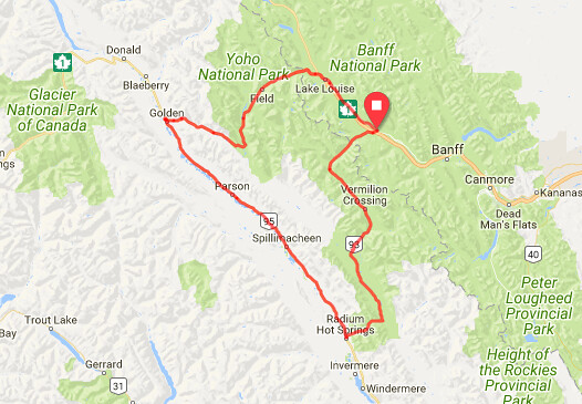
Here's the sort of route I prefer: Golden Triangle 300 copied from the Alberta Rando site
When I look at my local rando schedule I see so many very complicated routes that require a pretty extensive cue sheet or gps to navigate. They also seem to run through metro areas in a way that I would never actually want to bike for any sort of pleasure, given that we also have some of the best natural cycling routes around in the Fraser Valley that they seem to ignore. It's a bit of a turn off as I prefer clean aesthetic lines from A to B that follow straightforward routes. As a result I have been looking at my own routes outside the rando scene or, for next season, looking at brevets in the next province over.
Is it a rando "thing" to select complicated routes with an excess of directional changes or is it just a byproduct of my local rando routes being in urban areas?
Here's the sort of route I prefer: Golden Triangle 300 copied from the Alberta Rando site
Last edited by Happy Feet; 01-05-18 at 05:00 PM.
01-06-18, 01:58 AM
#12
Kamen Rider
Join Date: Aug 2017
Location: KL, MY
Posts: 1,071
Bikes: Fuji Transonic Elite, Marechal Soul Ultimate, Dahon Dash Altena
Mentioned: 11 Post(s)
Tagged: 0 Thread(s)
Quoted: 351 Post(s)
Liked 277 Times
in
164 Posts
You just made me realize that I also have glove problems on long rides. When I start to get tired and put more weight on my hands, my gloves will start to dig into the webbed skin part between my fingers. Probably not going to be that much of an issue for 200K, but something I'll need to think about if/when I start looking at 300K and beyond.
I've been looking up on how to convert TCX files to routes on RWGPS https://ridewithgps.com/help/ride-into-a-route, turns out that in order to maintain cue sheets within RWGPS itself I'll need to manually trace the route with the route planner. Guess that's more work for me to do, but at least I'll be able to get a proper route done in RWGPS eventually.
01-06-18, 02:20 AM
#13
Senior Member
I've been looking up on how to convert TCX files to routes on RWGPS https://ridewithgps.com/help/ride-into-a-route, turns out that in order to maintain cue sheets within RWGPS itself I'll need to manually trace the route with the route planner. Guess that's more work for me to do, but at least I'll be able to get a proper route done in RWGPS eventually.
01-06-18, 09:02 AM
#14
Randomhead
Join Date: Aug 2008
Location: Happy Valley, Pennsylvania
Posts: 24,386
Mentioned: 0 Post(s)
Tagged: 0 Thread(s)
Quoted: 4 Post(s)
Liked 3,687 Times
in
2,510 Posts
I don't know anything about your area. I also prefer fewer turns, if possible. There are two factors that may cause people to do something different. First is proof of passage (including places to resupply) and second is to guard against shortcuts. The latter has ruined a lot of otherwise nice routes. Some people like urban routes just because they are different. I have a route that goes through Altoona PA. That part is very complicated, there is just no easy way through the city and the sprawl surrounding it.
01-06-18, 09:05 AM
#15
Senior Member

They also publish the route online in a way that lets you export a GPX, TCX or KML track for use in electronic devices, which is why I almost never have to use a paper cue sheet.
01-06-18, 07:45 PM
#16
In Real Life
Thread Starter
Join Date: Jan 2003
Location: Down under down under
Posts: 52,152
Bikes: Lots
Mentioned: 141 Post(s)
Tagged: 0 Thread(s)
Quoted: 3203 Post(s)
Liked 596 Times
in
329 Posts
Hey, I have a question.
When I look at my local rando schedule I see so many very complicated routes that require a pretty extensive cue sheet or gps to navigate. They also seem to run through metro areas in a way that I would never actually want to bike for any sort of pleasure, given that we also have some of the best natural cycling routes around in the Fraser Valley that they seem to ignore. It's a bit of a turn off as I prefer clean aesthetic lines from A to B that follow straightforward routes. As a result I have been looking at my own routes outside the rando scene or, for next season, looking at brevets in the next province over.
Is it a rando "thing" to select complicated routes with an excess of directional changes or is it just a byproduct of my local rando routes being in urban areas?
Often routes are designed because someone in the area loves cycling that particular road, so they find a way to include it on a route. Sometimes it is historical ... in the past you couldn't get from A to B, you had to go by way of C, D, and E. Now you can go directly A to B, but the route hasn't been updated. Sometimes it is done to get the extra km needed to be a full 200 km or something. Sometimes there's a theme going on ... the route is taking you to this place and that place, all part of a theme. Sometimes it depends on controls. Sometimes it is done to keep the riders from being bored.
I like fairly straightforward routes too, but I've had to do some wonky things here and there with mine in order to accomplish something ... usually having to do with distance and controls and hill avoidance. Yes, hill avoidance. We've got a series of routes in Southern Tasmania which tend to be quite hilly. So I've got a series of routes in Northern Tasmania which are not. Gives riders a choice ... they can do both or the ones they prefer.
But in order for me to avoid hills, I sometimes have to make the routes go around them which can result in some creative routes. Also, since all our Northern routes start and finish in the same location, and there are a decent number of roads to choose from, I try not to overuse the same roads for each route. So some might be relatively straightforward, while others might wander a bit.
__________________
Rowan
My fave photo threads on BF
Century A Month Facebook Group
Machka's Website
Photo Gallery
Rowan
My fave photo threads on BF
Century A Month Facebook Group
Machka's Website
Photo Gallery
01-06-18, 08:32 PM
#17
Senior Member
Join Date: Sep 2015
Location: Left Coast, Canada
Posts: 5,126
Mentioned: 24 Post(s)
Tagged: 0 Thread(s)
Quoted: 2236 Post(s)
Liked 1,314 Times
in
707 Posts
I suppose I will.
I chalked it up to the designers being urban so having routes that start where they live saves a car commute to a more rural locale.
I just e-mailed someone from the Alberta randonneur club today to enquire about a couple of spring rides I'm interested in for May, the golden triangle 300 or the vermilion 400. I have a week off then and really like that region so if it works I'll try one of those. Locally there is an out and back run up to Cache Creek 600 that follows a pretty simple route too and In the fall there is the Mica Dam 300 in Revelstoke so no real shortage
01-07-18, 11:48 AM
#18
Senior Member
Or the routes do things like follow a numbered route, but that numbered route has a lot of turns/local road name changes. A lot of the older NER cue sheets (which tended to use larger numbered roads more) have things like "follow route 62 for ten miles" alongside the cues for dozens of turns required to follow route 62 for ten miles. The newer routes tend to eschew the numbered routes for quieter roads most of the time, but that means even more turns, usually.
The longest route I've designed is our overnight 200k, which had the added complexity of needing to have controls that were open in the middle of the night, and wanting to not end it with people having to ride east into the sunrise, which meant going either north or south, not west like most of our routes (which gets you to rural riding faster). I did take it through one slightly more urban area than most people would (Lowell), but there's only a handful of bridges over the Merrimack River, and picking one of the ones that's in a quiet area would have substantially changed the shape of the route -- it was 2 miles of quickly zipping through a slightly ugly urban area at 10-11pm before the drunks are out in force vs having to give up the really nice 10 mile stretch with no turns on a rural numbered route just north of Lowell.
01-07-18, 11:59 AM
#19
Zircon Encrusted Tweezers

Join Date: Nov 2008
Location: high ground
Posts: 1,346
Mentioned: 5 Post(s)
Tagged: 0 Thread(s)
Quoted: 260 Post(s)
Liked 127 Times
in
82 Posts
Its impossible to optimize everything simultaneously in a route design. It's just like bike design, or anything else for that matter. Sometimes navigational simplicity takes a back seat to some other issue. My route designs tend to be complicated because I put safety and scenery near the top of the priority list. In my neck of the woods, this forces lots of turns. I personally like lots of turns as it keeps me mentally engaged. One of my main struggles on randonees is boredom.
01-08-18, 09:51 AM
#20
Senior Member
Join Date: Apr 2007
Location: Raleigh, NC
Posts: 809
Mentioned: 3 Post(s)
Tagged: 0 Thread(s)
Quoted: 39 Post(s)
Likes: 0
Liked 2 Times
in
2 Posts
A few things not mentioned above that lead to route wiggle-abouts in central NC (and the hill and mountain country further west); the dawg thing in particular is not noted above:
- sometimes we put in temporary wiggles to avoid a particularly annoying dawg or two. Sometimes those temporary wiggles become more-or-less permanent. (this route, built entirely of segments from permanent and brevet routes has three wiggles that resulted from dawg avoidance - one added no distance and has better quality roads, the other two added nearly de minimus distance and either have better quality roads or fewer turns(?)).
- bridge re-destruction, which on occasion has led to a preferred routing which became more-or-less permanent (the Raleigh Region brevet routes have needed bridge-out detours on most every route most of the years since 2012). The Carolina Spring 1200 had at least one bridge-out wiggle (see the one photo in this ride report).
- since we prefer "remote" rural roads and routes, with little to no traffic, with controls located at what are essentially old-time "mom-and-pop" stores, sometimes the stores close (second time we rode the "Egypt Mtn" perm).
- I grew up in the flat of NW Illinois where one could design a route with as little as 1 turn (at a turn-around). However, here in NC, there are no straight roads and the preferred back-roads usually only continue for several miles, and then a turn is required.
- and one thing that I'm sure occurs elsewhere: sometimes we have to route around lakes and ponds, mostly man-made, often there are roads now submerged under water that we must go-around.
Last edited by skiffrun; 01-08-18 at 09:59 AM.
01-25-18, 12:39 AM
#21
Randomhead
Join Date: Aug 2008
Location: Happy Valley, Pennsylvania
Posts: 24,386
Mentioned: 0 Post(s)
Tagged: 0 Thread(s)
Quoted: 4 Post(s)
Liked 3,687 Times
in
2,510 Posts
Just registered for the DC Randonneurs BRB 1200k. I'll probably register for the Mac 'n' Cheese 1200k when that opens up
01-25-18, 01:38 AM
#22
Senior Member

Join Date: Nov 2014
Location: Eugene, Oregon, USA
Posts: 27,547
Mentioned: 217 Post(s)
Tagged: 0 Thread(s)
Quoted: 18350 Post(s)
Liked 4,502 Times
in
3,346 Posts
Then import GPX to Strava.
https://labs.strava.com/gpx-to-route/
I've had troubles with the utility midday (USA), but it has worked for me late at night or the wee hours of the morning.
Strava, of course, allows real time routes.
Only issue is if I hit the wrong button, the route vanishes since I use a non-connected phone for Strava.  01-27-18, 07:47 AM
#23

multimodal commuter

Join Date: Nov 2006
Location: NJ, NYC, LI
Posts: 19,808
Bikes: 1940s Fothergill, 1959 Allegro Special, 1963? Claud Butler Olympic Sprint, Lambert 'Clubman', 1974 Fuji "the Ace", 1976 Holdsworth 650b conversion rando bike, 1983 Trek 720 tourer, 1984 Counterpoint Opus II, 1993 Basso Gap, 2010 Downtube 8h, and...
Mentioned: 584 Post(s)
Tagged: 0 Thread(s)
Quoted: 1908 Post(s)
Liked 574 Times
in
339 Posts
I've signed up for the BRB 1000, which will be my longest randonnee to date; and I plan to sign up for the Mac & Cheese.
To qualify for the Mac D Cheese I'll have to complete an SR series by mid June, which is fine.
Nonetheless I'm not happy about the requirement that I sign up and pay for the ride seven months in advance with no certainty that I'll qualify to ride it until many months later, at which point I can get only 20% of my payment back, if I fail to qualify or have to back out for unforeseen reasons. That just seems a little too much like gambling for my taste (and I loathe gambling).
01-27-18, 08:54 AM
#24
Randomhead
Join Date: Aug 2008
Location: Happy Valley, Pennsylvania
Posts: 24,386
Mentioned: 0 Post(s)
Tagged: 0 Thread(s)
Quoted: 4 Post(s)
Liked 3,687 Times
in
2,510 Posts
I'm not particularly happy about it either, but running a 1200k is a big task, and having funding up front makes planning a lot easier. People would not promote these rides if they had to worry about no-shows. And you are going to qualify, so don't worry about that.
01-27-18, 04:38 PM
#25
multimodal commuter
Join Date: Nov 2006
Location: NJ, NYC, LI
Posts: 19,808
Bikes: 1940s Fothergill, 1959 Allegro Special, 1963? Claud Butler Olympic Sprint, Lambert 'Clubman', 1974 Fuji "the Ace", 1976 Holdsworth 650b conversion rando bike, 1983 Trek 720 tourer, 1984 Counterpoint Opus II, 1993 Basso Gap, 2010 Downtube 8h, and...
Mentioned: 584 Post(s)
Tagged: 0 Thread(s)
Quoted: 1908 Post(s)
Liked 574 Times
in
339 Posts

No, I'm not too worried about qualifying. It won't be easy but I'm stubborn.
And yes, of course, I understand the organizers need funding up front and later cannot return money they've already spent.
Nonetheless, there's a good chance that some riders who register and pay will be unable to do the ride for one reason or another; and an equally good chance that someone wants to do the ride but failed to register. If I happened to be one of those, do you think I could sell my registration to someone on the waiting list?
Sorry, wrong forum, that was a rhetorical question. I should pose it to the organizers.