


ACA PCH route decision point south of Santa Cruz?
 09-07-18, 08:38 PM
#26
Every day a winding road
Thread Starter


But you got me thinking. If I do this alone maybe just jump on the train from Santa Cruz to Monterrey. and skip the boring parts. But I would .never answer my question on that intersection.
 09-07-18, 08:44 PM
#27
Every day a winding road
Thread Starter
The other ride I will likely skip is 17 mile drive. Nice but not worth the extra miles IMHO.
09-07-18, 08:52 PM
#28
Every day a winding road
Thread Starter
And it gets boring again pretty much just past Ragged Point. If there was a major town right nearby I would end it there. If I do this next year I would likely end it in San Luis Opsipo.
09-07-18, 08:56 PM
#29
Occam's Rotor
Join Date: Jul 2013
Posts: 7,248
Mentioned: 61 Post(s)
Tagged: 0 Thread(s)
Quoted: 2366 Post(s)
Liked 2,331 Times
in
1,164 Posts
09-07-18, 08:57 PM
#30
Occam's Rotor
Join Date: Jul 2013
Posts: 7,248
Mentioned: 61 Post(s)
Tagged: 0 Thread(s)
Quoted: 2366 Post(s)
Liked 2,331 Times
in
1,164 Posts
I would suggest SF to Santa Barbara, and then take Amcrash back to Oakland.
09-07-18, 09:03 PM
#31
Occam's Rotor
Join Date: Jul 2013
Posts: 7,248
Mentioned: 61 Post(s)
Tagged: 0 Thread(s)
Quoted: 2366 Post(s)
Liked 2,331 Times
in
1,164 Posts
I think you are taking that far too seriously. I read it as clearly being light-hearted.
09-07-18, 09:17 PM
#32
Every day a winding road
Thread Starter
09-07-18, 09:23 PM
#33
Every day a winding road
Thread Starter
And you don't need to go to Santa Barbara to get Amtrak. There is a station at SLO.
09-07-18, 09:36 PM
#34
Senior Member
Join Date: Nov 2008
Location: Bay Area, Calif.
Posts: 7,239
Mentioned: 13 Post(s)
Tagged: 0 Thread(s)
Quoted: 659 Post(s)
Likes: 0
Liked 7 Times
in
6 Posts
I remember coming down Thurwachter/McGowan road to the T-intersection with Trafton and seeing a Pacific Coast Bike route sign pointing both directions on Trafton. Going to the right leads you up a short but fairly steep section to Bluff Rd. while going to the left avoids that little hill but you end up on the other side of Hwy. 1. So when you rejoin it you need to make a left turn across sometimes heavy traffic while with the Bluff Rd. option you make an easier right turn to continue on Hwy. 1.
09-08-18, 08:28 AM
#35
Every day a winding road
Thread Starter
I remember coming down Thurwachter/McGowan road to the T-intersection with Trafton and seeing a Pacific Coast Bike route sign pointing both directions on Trafton. Going to the right leads you up a short but fairly steep section to Bluff Rd. while going to the left avoids that little hill but you end up on the other side of Hwy. 1. So when you rejoin it you need to make a left turn across sometimes heavy traffic while with the Bluff Rd. option you make an easier right turn to continue on Hwy. 1.
https://www.google.com/maps/@36.8713...7i13312!8i6656
Looks like the sign only points to the right but I belief WGScott's map shows a left at that intersection.
Do you remember how far off that intersection it was?
The one I am remembering, the foot of the hill started right at the intersection. Hill was right in front of the intersection. More of keep going straight than a turn. Hill was very, very steep. I may even had to push up the hill. The road to the right was a nice flat road with a bit of a curve to the left.
Not really important. I might even be mixing an intersection from some other tour somewhere.
09-08-18, 11:59 AM
#36
Every day a winding road
Thread Starter
The one thing I also remember about that section from Santa Cruz to Monterrey is how difficult it was for me. I was dead tired approaching Monterrey. I had only come from Santa Cruz! It is only 47 miles or so. I don't know if it was the boredom. It being as flat as it was or what. But go to the bike path that heads into town and didn't think I would make i tthe rest of the way.
09-10-18, 06:47 PM
#37
Senior Member
Join Date: Nov 2008
Location: Bay Area, Calif.
Posts: 7,239
Mentioned: 13 Post(s)
Tagged: 0 Thread(s)
Quoted: 659 Post(s)
Likes: 0
Liked 7 Times
in
6 Posts
This intersection?
https://www.google.com/maps/@36.8713...7i13312!8i6656
Looks like the sign only points to the right but I belief WGScott's map shows a left at that intersection.
Do you remember how far off that intersection it was?
https://www.google.com/maps/@36.8713...7i13312!8i6656
Looks like the sign only points to the right but I belief WGScott's map shows a left at that intersection.
Do you remember how far off that intersection it was?
09-10-18, 07:35 PM
#38
Every day a winding road
Thread Starter
Well that is not how I remember it but that has to be it. The hill certainly looks steep enough. And I did take Bluff Rd. I am just remembering a Y or some reason with the"other" option to the right. . But your mind can play tricks with you too.
09-10-18, 07:39 PM
#39
Occam's Rotor
Join Date: Jul 2013
Posts: 7,248
Mentioned: 61 Post(s)
Tagged: 0 Thread(s)
Quoted: 2366 Post(s)
Liked 2,331 Times
in
1,164 Posts
The one thing I also remember about that section from Santa Cruz to Monterrey is how difficult it was for me. I was dead tired approaching Monterrey. I had only come from Santa Cruz! It is only 47 miles or so. I don't know if it was the boredom. It being as flat as it was or what. But go to the bike path that heads into town and didn't think I would make i tthe rest of the way.
09-10-18, 08:30 PM
#40
Every day a winding road
Thread Starter
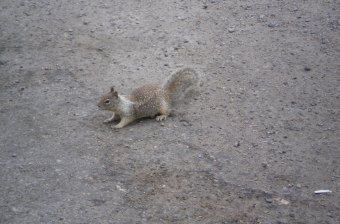
That is what I was thinking but don't remember anything of significance. But before Moss Landing we had a hell of a tail wind. I remember doing almost 24MPH on flat ground and hardly trying.
I do remember entering that bike path and saw these crazy little animals darting about. No idea what they were.. They were too far away and moving too fast to get a good look. We would see them all over the place.
Then finally somewhere before Big Sur a good look.
I do remember entering that bike path and saw these crazy little animals darting about. No idea what they were.. They were too far away and moving too fast to get a good look. We would see them all over the place.
Then finally somewhere before Big Sur a good look.
09-10-18, 08:55 PM
#41
Occam's Rotor
Join Date: Jul 2013
Posts: 7,248
Mentioned: 61 Post(s)
Tagged: 0 Thread(s)
Quoted: 2366 Post(s)
Liked 2,331 Times
in
1,164 Posts
Ground squirrels.
Because of the Bay, you can often get headwinds going in the opposite direction of the prevailing winds. In my 1988 trip, we ground to a halt at Sand City.
Because of the Bay, you can often get headwinds going in the opposite direction of the prevailing winds. In my 1988 trip, we ground to a halt at Sand City.

Thread
Thread Starter
Forum
Replies
Last Post
army14
Southern California
20
07-02-13 05:27 PM
CyciumX
Road Cycling
40
05-05-10 10:09 PM
