


Garmin Edge 1030 Map Display Color Settings
 08-08-19, 07:12 AM
#1
meh
Thread Starter

Join Date: Jul 2014
Location: Hopkins, MN
Posts: 4,702
Bikes: 23 Cutthroat, 21 CoMotion Java; 21 Bianchi Infinito; 15 Surly Pugsley; 11 Globe Daily; 09 Kona Dew Drop; 96 Mondonico
Mentioned: 22 Post(s)
Tagged: 0 Thread(s)
Quoted: 1110 Post(s)
Liked 1,012 Times
in
518 Posts
Garmin Edge 1030 Map Display Color Settings
I've been using my 1030 for a year and find the maps/routes to be excellent ... and I get out a couple times a month on rides to places I've never been before.
My one whine, the route can be hard to see in the map field. The promo image on Garmin looks like this:
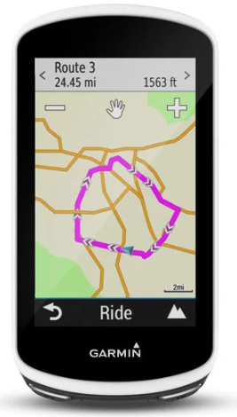
The display on my 1030, the route is a light blue line on a busy field of roads in red and grey, creeks and rivers in dark blue along with many road and place names. It's a busy field that makes it damn near impossible to see the route, where you're going and where you've been. The image above is great, with the route in hot pink... I'd LOVE that.
I've looked at Garmin's site and reviewed a lot of how-to videos and not finding any good info to help. Is the above image just a promo, or regionally specific? Or can I change the color of my maps to make the route easier to see on the display?
Thanks!
(edit/afterthought) - in the map settings, I can change the color of the route, but there's no hot pink, and the other colors all blend too easily with maps default color set)
My one whine, the route can be hard to see in the map field. The promo image on Garmin looks like this:
The display on my 1030, the route is a light blue line on a busy field of roads in red and grey, creeks and rivers in dark blue along with many road and place names. It's a busy field that makes it damn near impossible to see the route, where you're going and where you've been. The image above is great, with the route in hot pink... I'd LOVE that.
I've looked at Garmin's site and reviewed a lot of how-to videos and not finding any good info to help. Is the above image just a promo, or regionally specific? Or can I change the color of my maps to make the route easier to see on the display?
Thanks!
(edit/afterthought) - in the map settings, I can change the color of the route, but there's no hot pink, and the other colors all blend too easily with maps default color set)
Last edited by Hypno Toad; 08-08-19 at 07:28 AM.
 08-08-19, 08:07 AM
#2
Senior Member
Join Date: Sep 2007
Location: Far beyond the pale horizon.
Posts: 14,254
Mentioned: 31 Post(s)
Tagged: 0 Thread(s)
Quoted: 4242 Post(s)
Liked 1,343 Times
in
932 Posts
Go to the settings menu (the three horizontal lines at the lower right of the home screen).
1- Activity Profiles
2- Pick the activity profile.
3- Navigation
4- Map
5- Map Visibility
6- Custom (you can change how/what things are displayed).
You can set a course to always display. You can pick various colors for that. A lightish blue is one option; green seems to be a better choice. "Hot pink" isn't an option (magenta is reserved by Garmin for displaying routes being used for active navigation).
The "hot pink" (magenta) is a course/route being used for navigation. The Edges don't let you change the color used for this (magenta is reserved by Garmin for displaying the course being used for navigation).
If you using a loaded course (track), it's drawn as a magenta line with black borders (it looks purple).
The route calculated by the unit is drawn as magenta. It's wider than the track line.
Since you talk about a "light blue line", you don't seem to be using navigation (either with a loaded course or a calculated route).
It's a preview mode for displaying a calculated route. The preview mode doesn't display as much detail. It's also very zoomed-out, which also means less detail is displayed.
It looks like it might be using the basemap rather than the detailed map used for navigation (the basemap has much less detail).
Also, It's the same bitmap but displayed on a more-vivid screen (whatever your computer is using).
The displays on the Garmins are not as vivid (so the same image will appear a bit "washed out").
This is a result of the Garmin display being usable in bright sunlight without a backlight.
1- Activity Profiles
2- Pick the activity profile.
3- Navigation
4- Map
5- Map Visibility
6- Custom (you can change how/what things are displayed).
The "hot pink" (magenta) is a course/route being used for navigation. The Edges don't let you change the color used for this (magenta is reserved by Garmin for displaying the course being used for navigation).
If you using a loaded course (track), it's drawn as a magenta line with black borders (it looks purple).
The route calculated by the unit is drawn as magenta. It's wider than the track line.
Since you talk about a "light blue line", you don't seem to be using navigation (either with a loaded course or a calculated route).
It's a preview mode for displaying a calculated route. The preview mode doesn't display as much detail. It's also very zoomed-out, which also means less detail is displayed.
It looks like it might be using the basemap rather than the detailed map used for navigation (the basemap has much less detail).
Also, It's the same bitmap but displayed on a more-vivid screen (whatever your computer is using).
The displays on the Garmins are not as vivid (so the same image will appear a bit "washed out").
This is a result of the Garmin display being usable in bright sunlight without a backlight.
Last edited by njkayaker; 08-08-19 at 08:32 AM.
08-08-19, 09:08 AM
#3
meh
Thread Starter
Join Date: Jul 2014
Location: Hopkins, MN
Posts: 4,702
Bikes: 23 Cutthroat, 21 CoMotion Java; 21 Bianchi Infinito; 15 Surly Pugsley; 11 Globe Daily; 09 Kona Dew Drop; 96 Mondonico
Mentioned: 22 Post(s)
Tagged: 0 Thread(s)
Quoted: 1110 Post(s)
Liked 1,012 Times
in
518 Posts
The "hot pink" (magenta) is a course/route being used for navigation. The Edges don't let you change the color used for this (magenta is reserved by Garmin for displaying the course being used for navigation).
If you using a loaded course (track), it's drawn as a magenta line with black borders (it looks purple).
The route calculated by the unit is drawn as magenta. It's wider than the track line.
Since you talk about a "light blue line", you don't seem to be using navigation (either with a loaded course or a calculated route).
Thank you for the detailed post!!
I'm interested in the comment about using navigation ... I thought I was using navigation.
I use Strava to build a route, export the the .gpx to PC desktop, plug in the 1030 (USB) and add the .gpx to the "NewFiles" folder in the 1030 (kinda old school, but it's the same way I've done it since my old 510).
On the 1030, tap 'Navigate' --> 'Course' --> 'Saved Courses' --> select course --> tap 'Ride' and start 1030
Is this a file type issue? Export a TCX instead of GPX?
By adding a place in the 1030 navigation, I was able to see the magenta route on the map.
08-08-19, 09:39 AM
#4
Senior Member
Join Date: Sep 2007
Location: Far beyond the pale horizon.
Posts: 14,254
Mentioned: 31 Post(s)
Tagged: 0 Thread(s)
Quoted: 4242 Post(s)
Liked 1,343 Times
in
932 Posts
Note that you might need/want to enable "turn guidance", which will display big white arrows at the turn.
Do that by clicking the hamburger (three horizontal lines) menu at the lower right of the "Saved Courses" list.
It appears that, with "light blue line", you are referring to your recorded track (showing where you have been).
No, fit, tcx, and gpx all contain the same information.
That's another way to get the magenta line.
Last edited by njkayaker; 08-08-19 at 09:43 AM.
08-08-19, 09:46 AM
#5
meh
Thread Starter
Join Date: Jul 2014
Location: Hopkins, MN
Posts: 4,702
Bikes: 23 Cutthroat, 21 CoMotion Java; 21 Bianchi Infinito; 15 Surly Pugsley; 11 Globe Daily; 09 Kona Dew Drop; 96 Mondonico
Mentioned: 22 Post(s)
Tagged: 0 Thread(s)
Quoted: 1110 Post(s)
Liked 1,012 Times
in
518 Posts
njkayaker - Thanks for the help! I have some things to try out on my next ride.
08-29-19, 10:15 AM
#6
meh
Thread Starter
Join Date: Jul 2014
Location: Hopkins, MN
Posts: 4,702
Bikes: 23 Cutthroat, 21 CoMotion Java; 21 Bianchi Infinito; 15 Surly Pugsley; 11 Globe Daily; 09 Kona Dew Drop; 96 Mondonico
Mentioned: 22 Post(s)
Tagged: 0 Thread(s)
Quoted: 1110 Post(s)
Liked 1,012 Times
in
518 Posts
Update: I think I was missing one click in the start route process ... but now I see the magenta route line and can't see the less visible route line. It feels like calling the tech support to your desk to help with a problem and when they're there, the problem is no longer present. 
08-29-19, 10:39 AM
#7
Senior Member
Join Date: Sep 2007
Location: Far beyond the pale horizon.
Posts: 14,254
Mentioned: 31 Post(s)
Tagged: 0 Thread(s)
Quoted: 4242 Post(s)
Liked 1,343 Times
in
932 Posts
Update: I think I was missing one click in the start route process ... but now I see the magenta route line and can't see the less visible route line. It feels like calling the tech support to your desk to help with a problem and when they're there, the problem is no longer present.

Thread
Thread Starter
Forum
Replies
Last Post
Flounce
Long Distance Competition/Ultracycling, Randonneuring and Endurance Cycling
27
02-11-18 01:49 AM
DTownDave22
Electronics, Lighting, & Gadgets
6
06-01-16 08:02 PM


