


Indiana Glacier extent
 11-12-19, 01:34 PM
#1
Newbie
Thread Starter
Join Date: Nov 2019
Posts: 4
Mentioned: 0 Post(s)
Tagged: 0 Thread(s)
Quoted: 1 Post(s)
Likes: 0
Liked 0 Times
in
0 Posts
Indiana Glacier extent
I once had a book on bike routes in Indiana, around the Bloomington area, and up towards Indianapolis. There was one ride that had some dramatic views of where the glaciers ended. But I don't have the book anymore. Does that sound like something anyone here has done?
Thanks. I hoping to get down there next Fall.
Thanks. I hoping to get down there next Fall.
 11-15-19, 03:30 PM
#2
Senior Member
There's always Hilly Hundred, which is based in Ellettsville, IN every October, which covers that area. Ellettsvillis is about 10 miles west of Bloomington. I've done many HHs, although not recently. The specific weekend it's held is dependent on the football schedule of the local HS; and you really don't want to do it in years when it's held in the last half of October.
11-15-19, 06:29 PM
#3
Newbie
Thread Starter
Join Date: Nov 2019
Posts: 4
Mentioned: 0 Post(s)
Tagged: 0 Thread(s)
Quoted: 1 Post(s)
Likes: 0
Liked 0 Times
in
0 Posts
I lived just south of Elletsville for a year, that's down in to the hilly area. I'm thinking it might be more over by Trafalgar or Morgantown, where the farmland meets the hills.
11-30-19, 05:05 PM
#4
Senior Member

Join Date: Jul 2014
Location: Central Indiana
Posts: 2,159
Mentioned: 27 Post(s)
Tagged: 0 Thread(s)
Quoted: 912 Post(s)
Liked 515 Times
in
344 Posts
 11-30-19, 05:23 PM
#5
Senior Member
Join Date: Jul 2014
Location: Central Indiana
Posts: 2,159
Mentioned: 27 Post(s)
Tagged: 0 Thread(s)
Quoted: 912 Post(s)
Liked 515 Times
in
344 Posts
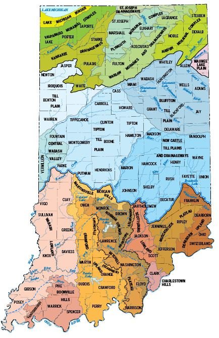
As you can see by this map the "Tipton Till Plain" and the "New Castle Plain" south boundary extends from state line to state line. I believe these plains were deep, deep almost impenetrable forest until the settlers moved in and stripped it bare. By the way, JohnBoy7 welcome to the forums and keep posting!
12-02-19, 02:39 PM
#6
Newbie
Thread Starter
Join Date: Nov 2019
Posts: 4
Mentioned: 0 Post(s)
Tagged: 0 Thread(s)
Quoted: 1 Post(s)
Likes: 0
Liked 0 Times
in
0 Posts
Thanks FBO. I'm thinking I'll head to Nashville (IN not TN) and head north, then go east and west and hope I find something. I'm sure it will be a nice trip no matter what.
12-02-19, 03:17 PM
#7
Senior Member
Join Date: Jul 2014
Location: Central Indiana
Posts: 2,159
Mentioned: 27 Post(s)
Tagged: 0 Thread(s)
Quoted: 912 Post(s)
Liked 515 Times
in
344 Posts
Sure thing! Do some amateur cartography and transpose that boundary line on a road map that shows county roads and you'll see stuff. People just driving the highways seldom notice the subtle changes between flat and hilly. And take pics and report back. We like pics!
12-25-19, 12:02 PM
#8
dollar-store reject
The Geology Dept at IU would be a good resource. I have a daughter that lives in Martinsville, and I've used their mapping a couple of times to alleviate drainage problems on her property.
Here's the link https://maps.indiana.edu/
There's like 200 layers you can add to a dozen or so base maps.
Here's the link https://maps.indiana.edu/
There's like 200 layers you can add to a dozen or so base maps.
Last edited by JLDickmon; 01-01-20 at 06:29 AM.
09-04-20, 04:48 PM
#9
Newbie
Thread Starter
Join Date: Nov 2019
Posts: 4
Mentioned: 0 Post(s)
Tagged: 0 Thread(s)
Quoted: 1 Post(s)
Likes: 0
Liked 0 Times
in
0 Posts
I could swear I posted a couple pictures of the overlook just south of Beanblossom, IN. It comes after gaining 200 ft altitude in a short stretch.
Anyway. A good ride.
Anyway. A good ride.
Last edited by JohnBoy7; 09-04-20 at 04:54 PM.
09-04-20, 05:58 PM
#10
Senior Member
Join Date: Jul 2014
Location: Central Indiana
Posts: 2,159
Mentioned: 27 Post(s)
Tagged: 0 Thread(s)
Quoted: 912 Post(s)
Liked 515 Times
in
344 Posts
JohnBoy7
That's because you don't yet have the required 10 posts to post pictures. It's a necessary spam prevention rule. However, when you attempt to post pics they automatically go to your gallery instead. Where others can find them and help out. This is the pic I found there:
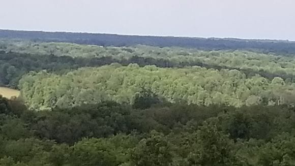
Is that Beanblossom Creek peeking out on the left?
That's because you don't yet have the required 10 posts to post pictures. It's a necessary spam prevention rule. However, when you attempt to post pics they automatically go to your gallery instead. Where others can find them and help out. This is the pic I found there:
Is that Beanblossom Creek peeking out on the left?
11-13-20, 07:12 PM
#11
Senior Member

As you can see by this map the "Tipton Till Plain" and the "New Castle Plain" south boundary extends from state line to state line. I believe these plains were deep, deep almost impenetrable forest until the settlers moved in and stripped it bare. By the way, JohnBoy7 welcome to the forums and keep posting!
Likes For Zoxe:
11-14-20, 07:14 PM
#12
dollar-store reject
JohnBoy7
That's because you don't yet have the required 10 posts to post pictures. It's a necessary spam prevention rule. However, when you attempt to post pics they automatically go to your gallery instead. Where others can find them and help out. This is the pic I found there:
Is that Beanblossom Creek peeking out on the left?
They live in Martinsville now..
Likes For JLDickmon:
11-25-20, 08:15 AM
#13
dollar-store reject
And by God, you can just about draw a line across Morgan Co.
North of that, dead flat. South, hills-n-hollers
Likes For JLDickmon:
11-25-20, 08:43 AM
#14
Senior Member
Join Date: Jul 2014
Location: Central Indiana
Posts: 2,159
Mentioned: 27 Post(s)
Tagged: 0 Thread(s)
Quoted: 912 Post(s)
Liked 515 Times
in
344 Posts
Checkout Hunter's Honey Farm if you have time, they're way up in the hills 'n hollers.
Last edited by FBOATSB; 11-25-20 at 08:49 AM.
11-25-20, 08:45 AM
#15
Senior Member
Join Date: Jul 2014
Location: Central Indiana
Posts: 2,159
Mentioned: 27 Post(s)
Tagged: 0 Thread(s)
Quoted: 912 Post(s)
Liked 515 Times
in
344 Posts
They built the interstate system, naturally, where you can hardly see any of that unless you know what to look for.
11-25-20, 02:51 PM
#16
dollar-store reject
Likes For JLDickmon:
