


830 anomalies
 08-03-20, 05:46 AM
#1
Hills!
Thread Starter
830 anomalies
I'm still pretty new to the 830 having come from an old Edge 305. I've noticed a routing anomaly that seems to occur consistently, at least on 1 route that I ride.
This particular route has a leg that starts from a T intersection and goes for about 1.25 miles, then I u-turn at a stoplight and retrace that leg and continue past the point where I initially turned onto the road. What I'm seeing is that about 1/4 mile before my u-turn, I'm getting a map alert to do an early u-turn.I ignore the directions and continue to my normal u-turn point, then reverse course. The 830 records everything of course, so it's no big deal. But I'm wondering if this is just an isolated issue or if that's a common issue when a u-turn is involved? I don't think I have another route that involves a planned u-turn like that on a different road. Normal turn alerts pop up at 1/10th mile intervals for me.
Secondly, about 40 miles into a 50 mile ride yesterday, the 830 popped up a message telling me the virtual partner something-or-other has ended. What is that all about? I did not intentionally set up any training event and have never intentionally used the virtual partner feature. Any thoughts?
 08-03-20, 08:58 AM
#2
Senior Member
Join Date: Sep 2007
Location: Far beyond the pale horizon.
Posts: 14,276
Mentioned: 31 Post(s)
Tagged: 0 Thread(s)
Quoted: 4259 Post(s)
Liked 1,361 Times
in
943 Posts
This particular route has a leg that starts from a T intersection and goes for about 1.25 miles, then I u-turn at a stoplight and retrace that leg and continue past the point where I initially turned onto the road. What I'm seeing is that about 1/4 mile before my u-turn, I'm getting a map alert to do an early u-turn.I ignore the directions and continue to my normal u-turn point, then reverse course. The 830 records everything of course, so it's no big deal. But I'm wondering if this is just an isolated issue or if that's a common issue when a u-turn is involved? I don't think I have another route that involves a planned u-turn like that on a different road. Normal turn alerts pop up at 1/10th mile intervals for me.
It's possible that this won't happen if you can tweak the route so that the legs are on the proper side of the road (so, they are separate lines). That's less of a recommendation than it is an attempt to explain how the problem happens.
Secondly, about 40 miles into a 50 mile ride yesterday, the 830 popped up a message telling me the virtual partner something-or-other has ended. What is that all about? I did not intentionally set up any training event and have never intentionally used the virtual partner feature. Any thoughts?
The track files have times associated with each point. Historically, the tracks were generated from a recorded ride. The "virtual partner" can use that information as something you can "race" against. Some of the route planners don't use "reasonable" speeds to add the time to the points. Your best option is to ignore it (if you can't turn it off).
Last edited by njkayaker; 08-03-20 at 10:00 AM.

Likes For njkayaker:
08-03-20, 08:59 AM
#3

I'm good to go!
Join Date: Jul 2017
Location: Mississippi
Posts: 14,992
Bikes: Tarmac Disc Comp Di2 - 2020
Mentioned: 51 Post(s)
Tagged: 0 Thread(s)
Quoted: 6195 Post(s)
Liked 4,810 Times
in
3,318 Posts
Most all my issues with my Garmin 500 were an issue with the interface between the saddle and the unit itself. With time it seemed to clear itself up.
I don't know for certain, but it seems when my son adds a new course to his edge 820 that the speed of the virtual partner is sometimes doing the course at speeds over 100 mph. I guess it's dependent on what ever he used to create the course. Don't know why the virtual partner gets activated though. I think it's turned off on my edge. Or maybe it's because I don't use courses or workouts.
Sorry I can't offer you any more. I just don't use those features.
I'm assuming though that the U-turn is something you actually built into your course and you are just getting messages you didn't expect.
Likes For Iride01:
08-03-20, 09:06 AM
#4
Senior Member

Join Date: Jun 2008
Location: Louisville, KY
Posts: 13,447
Mentioned: 33 Post(s)
Tagged: 0 Thread(s)
Quoted: 4236 Post(s)
Liked 2,949 Times
in
1,808 Posts
I think this is a quirk of U-turns on the units. I seem to recall this sort of behavior on the 800.
It's possible that this won't happen if you can tweak the route so that the legs are on the proper side of the road (so, they are separate lines). That's less of a recommendation than it to try to explain how the problem happens.
I don't think there's a way of turning that off on the 830.
The track files have times associated with each point. Historically, the tracks were generated from a recorded ride. The "virtual partner" can use that information as something you can "race" against. Some of the route planners don't use "reasonable" speeds to add the time to the points. Your best option is to ignore it (if you can't turn it off).
08-03-20, 09:19 AM
#5
Senior Member
Join Date: Sep 2007
Location: Far beyond the pale horizon.
Posts: 14,276
Mentioned: 31 Post(s)
Tagged: 0 Thread(s)
Quoted: 4259 Post(s)
Liked 1,361 Times
in
943 Posts
Some route planners let you change the speed used. The newer units might let you change the speed.
Seems easier to just ignore it.
Likes For njkayaker:
08-03-20, 10:07 AM
#6
Hills!
Thread Starter
It may be hard to turn off something that I never turned on in the first place! At least, not intentionally. I'll have to explore some on the 830 and see if I see anything that might have triggered the VP to activate.
I have a number of rides I've planned on RWGPS and imported into the 830. The ride yesterday was one I've done in the past, prior to buying the 830. Maybe I was slower yesterday than the last time I rode that route. Regardless, not sure how or why the VP was triggered unless I have inadvertently enabled VP.
As regards the u-turn, I'll just ignore the early turn instruction and assume it's a bug. This was another RWGPS route and I have learned to mark the road just after a turn in the direction I'm headed. I also mark the end of the road where I planned the u-turn. My next marker is about 4 miles away from the u-turn, so there shouldn't have been any conflict with the correct side of the road. But when I look at the RWGPS route, it shows the ride correctly, but there's no u-turn showing in the cuesheet. Not sure how RWGPS handles a u-turn... or if there's something I need to do when planning the course so I don't confuse the 830.
Ah well... it doesn't really affect anything. But I was mainly curious about that anomaly.
08-03-20, 10:37 AM
#7
Senior Member
Join Date: Jun 2008
Location: Louisville, KY
Posts: 13,447
Mentioned: 33 Post(s)
Tagged: 0 Thread(s)
Quoted: 4236 Post(s)
Liked 2,949 Times
in
1,808 Posts
I think RWGPS has you put in a default speed so that it can predict how long the route will take you. That could be what the virtual partner is using.
08-03-20, 10:42 AM
#8
Hills!
Thread Starter
I've moved away from the pop-up map to just a text display when the 830 provides guidance. At least when I'm riding in a known area. Do you know if that is a setting I can change on the fly or do I have to interrupt the ride to change the prompt style?
I'm also pleasantly surprised with the battery life. I can ride for several hours and still have 85% or better battery life remaining at the end of the ride. That might change when I pair the new Varia RTL515 (which should arrive today). Maybe not much. Not sure what to expect for a hit on the battery with the Varia, but regardless, the battery should last longer than I can ride anyway.
08-03-20, 10:44 AM
#9
Hills!
Thread Starter
If they do, I have no idea where that setting would be. I cannot find it in settings, preferences, or any other field I can modify.
08-03-20, 11:07 AM
#10
Senior Member
Join Date: Jun 2008
Location: Louisville, KY
Posts: 13,447
Mentioned: 33 Post(s)
Tagged: 0 Thread(s)
Quoted: 4236 Post(s)
Liked 2,949 Times
in
1,808 Posts
08-06-20, 12:06 PM
#11
Hills!
Thread Starter
A follow up on the u-turn issue. I planned a new route on RWGPS today and loaded it on my 830. This ride included the same road where I saw the way too early u-turn alert mentioned above, and prior to reaching that road, I mapped another road that also required a u-turn. This one routed normally and gave a normal alert for when to do the u-turn. Cool!
But when I began riding the next road that had the problematic u-turn, it again alerted at least 1/4 mile too early and that alert didn't go away until I passed that point 1/2 mile or so later... after continuing to the physical turn around spot and reversing course to the point where I got that early alert.
So for u-turn to work normally in some instances but not in other instances makes me wonder if it's a map issue?
08-06-20, 02:14 PM
#12
I'm good to go!
Join Date: Jul 2017
Location: Mississippi
Posts: 14,992
Bikes: Tarmac Disc Comp Di2 - 2020
Mentioned: 51 Post(s)
Tagged: 0 Thread(s)
Quoted: 6195 Post(s)
Liked 4,810 Times
in
3,318 Posts
There are cues that can be placed in the course file that tell the device when to give you alerts. Depends on the file format you use for some. Some websites and course creation tools give you control to varying degrees when and what alerts you get.
I'm thinking though that what you are getting is actually from the 830's navigation software and not contained in the course file you created. You may or may not have much control of that. As I don't use navigation features, I'm not the one to tell you with any certainty.
I've seen some others refer to that issue on other forums though and it seems they just had to figure out a way to trick it or just live with it.
You've been to the Garmin Forums haven't you? https://forums.garmin.com/sports-fitness/cycling/
08-06-20, 03:39 PM
#13
Hills!
Thread Starter
There are cues that can be placed in the course file that tell the device when to give you alerts. Depends on the file format you use for some. Some websites and course creation tools give you control to varying degrees when and what alerts you get.
I'm thinking though that what you are getting is actually from the 830's navigation software and not contained in the course file you created. You may or may not have much control of that. As I don't use navigation features, I'm not the one to tell you with any certainty.
I've seen some others refer to that issue on other forums though and it seems they just had to figure out a way to trick it or just live with it.
You've been to the Garmin Forums haven't you? https://forums.garmin.com/sports-fitness/cycling/
I'm thinking though that what you are getting is actually from the 830's navigation software and not contained in the course file you created. You may or may not have much control of that. As I don't use navigation features, I'm not the one to tell you with any certainty.
I've seen some others refer to that issue on other forums though and it seems they just had to figure out a way to trick it or just live with it.
You've been to the Garmin Forums haven't you? https://forums.garmin.com/sports-fitness/cycling/
No, I haven't been over to the Garmin forums.Thanks for the link!
Last edited by speedlever; 08-07-20 at 07:03 AM.
08-06-20, 04:12 PM
#14
I'm good to go!
Join Date: Jul 2017
Location: Mississippi
Posts: 14,992
Bikes: Tarmac Disc Comp Di2 - 2020
Mentioned: 51 Post(s)
Tagged: 0 Thread(s)
Quoted: 6195 Post(s)
Liked 4,810 Times
in
3,318 Posts
The different file formats that you export the course as can make a difference in things too. So you might try using different formats to export to your 830. Though some features are and aren't supported or available in the various file formats.
.fit files can't be easily read unless you have a special reader for them. .tcx and the other formats are simple text files and can be opened in a text editor. It's a markup language similar to HTML and fairly easy to grasp what is what. If you like doing tedious things, then parse through the file and see if you notice something different about that part of the course in them. Still I think it's the device and not the course file that is causing your annoyance.
.fit and .tcx files are the only type of course files that ever worked or worked well on my old edge 500.
08-06-20, 05:03 PM
#15
Senior Member
Join Date: Sep 2007
Location: Far beyond the pale horizon.
Posts: 14,276
Mentioned: 31 Post(s)
Tagged: 0 Thread(s)
Quoted: 4259 Post(s)
Liked 1,361 Times
in
943 Posts
Even so...
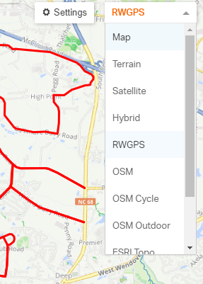
The Garmins use maps based on Openstreetmap (OSM) data. Most of the route planners let you use OSM maps (in RWGPS, there's a dropdown at the upper right of the map window that lets you change what map to use).
You'll tend to get better results if you use the same map to plan the route as is installed on the device. Though, the Edges can handle slight differences in maps just fine (generally).
PM me a link to the RWGPS route and I'll look at it.
Navigation works better if you look at the map page regularly. This is true whether or not you prefer having a data page displayed.
You won't be able to avoid all the "anomalies". It would be especially annoying if there was an anomaly in a regular route but, in practice, it's easy enough to handle them while riding.
I suspect that one thing that keeps some people from using these effectively is that they expect them to be easy to use. My position is that you have to think a bit and take the instructions as advice not commands. With some experience (and understanding), this becomes routine and you don't have to deal with it consciously.
It's generally better to live with the anomalies than it is to try to do "funny things" to the track.
Last edited by njkayaker; 08-06-20 at 06:40 PM.
08-06-20, 05:05 PM
#16
Senior Member
Join Date: Sep 2007
Location: Far beyond the pale horizon.
Posts: 14,276
Mentioned: 31 Post(s)
Tagged: 0 Thread(s)
Quoted: 4259 Post(s)
Liked 1,361 Times
in
943 Posts
There are cues that can be placed in the course file that tell the device when to give you alerts. Depends on the file format you use for some. Some websites and course creation tools give you control to varying degrees when and what alerts you get./
I'm thinking though that what you are getting is actually from the 830's navigation software and not contained in the course file you created. You may or may not have much control of that. As I don't use navigation features, I'm not the one to tell you with any certainty.
Outside of having course points, TCX, FIT, and GPX contain the same information (track points) and work exactly the same.
Some of the older units might not be able to use GPX at all. The 800 and newer can use all three formats.
.fit files can't be easily read unless you have a special reader for them. .tcx and the other formats are simple text files and can be opened in a text editor. It's a markup language similar to HTML and fairly easy to grasp what is what. If you like doing tedious things, then parse through the file and see if you notice something different about that part of the course in them.
Last edited by njkayaker; 08-06-20 at 06:37 PM.
08-06-20, 05:30 PM
#17
Senior Member
Join Date: Sep 2007
Location: Far beyond the pale horizon.
Posts: 14,276
Mentioned: 31 Post(s)
Tagged: 0 Thread(s)
Quoted: 4259 Post(s)
Liked 1,361 Times
in
943 Posts
Outside of having course points, TCX, FIT, and GPX will behave exactly the same (the data is the same in any of the formats).
Keep in mind that the Edges need track data (the "GPX route" option that RWGPS provides will not do useful things on the Edge).
The only difference is the presence or absence of course points. Only FIT and TCX files will have course points (but these formats won't necessarily have course points).
08-06-20, 05:43 PM
#18
I'm good to go!
Join Date: Jul 2017
Location: Mississippi
Posts: 14,992
Bikes: Tarmac Disc Comp Di2 - 2020
Mentioned: 51 Post(s)
Tagged: 0 Thread(s)
Quoted: 6195 Post(s)
Liked 4,810 Times
in
3,318 Posts
No.
Outside of having course points, TCX, FIT, and GPX will behave exactly the same (the data is the same in any of the formats).
Keep in mind that the Edges need track data (the "GPX route" option that RWGPS provides will not do useful things on the Edge).
The only difference is the presence or absence of course points. Only FIT and TCX files will have course points (but these formats won't necessarily have course points).
I wasn't making a statement that the format of the file couldn't have that type data. Just saying that some sites route tools might not put the same abilities in every format it can export.
08-06-20, 05:52 PM
#19
Senior Member
Join Date: Sep 2007
Location: Far beyond the pale horizon.
Posts: 14,276
Mentioned: 31 Post(s)
Tagged: 0 Thread(s)
Quoted: 4259 Post(s)
Liked 1,361 Times
in
943 Posts
The same route planner is putting the same data in the files regardless of the format.
Except for course points (as I've repeatedly pointed out), which aren't available for GPX files.
Different planners (if using the same map) will output different track points but that difference doesn't matter (except, maybe, in really rare cases).
Different maps will output different track points because the roads don't have the same place in different maps. That can cause some differences in behavior (the data is different!) but it generally doesn't matter if the roads aren't in places that are too different.
Course points are optional for TCX and FIT files.
* RWGPS adds the same course points for the FIT and TCX files it exports.
* Garmin Connect will export the custom cues as course points for all devices but it will only export the normal course points for devices that don't use "turn guidance".
The OP is using RWGPS anyway. Vague talk about what other sites might or might not do is only going to confuse people.
The difference is the presence or absence of course points.
There's a good chance that the OP isn't using course points and has no idea what they are. But you don't mention them anyway. You talk about formats.
The GPX format has no way of encoding "course points" ("course points" are a Garmin-specific thing). FIT and TCX are (basically) Garmin formats.
You don't need the "course points" if your device supports "turn guidance" (if your track is following roads/paths on the installed map).
Last edited by njkayaker; 08-06-20 at 06:39 PM.
08-07-20, 06:54 AM
#20
Hills!
Thread Starter
I don't think so.
Even so...
The Garmins use maps based on Openstreetmap (OSM) data. Most of the route planners let you use OSM maps (in RWGPS, there's a dropdown at the upper right of the map window that lets you change what map to use).
You'll tend to get better results if you use the same map to plan the route as is installed on the device. Though, the Edges can handle slight differences in maps just fine (generally).
PM me a link to the RWGPS route and I'll look at it.
Your OCD can't be that bad if you can call it "ODC"!
Navigation works better if you look at the map page regularly. This is true whether or not you prefer having a data page displayed.
You won't be able to avoid all the "anomalies". It would be especially annoying if there was an anomaly in a regular route but, in practice, it's easy enough to handle them while riding.
I suspect that one thing that keeps some people from using these effectively is that they expect them to be easy to use. My position is that you have to think a bit and take the instructions as advice not commands. With some experience (and understanding), this becomes routine and you don't have to deal with it consciously.
It's generally better to live with the anomalies than it is to try to do "funny things" to the track.
Ok. I'll PM you the route.
I've never paid attention to those routing options before. Interesting!
 08-07-20, 09:57 AM
#21
I'm good to go!
Join Date: Jul 2017
Location: Mississippi
Posts: 14,992
Bikes: Tarmac Disc Comp Di2 - 2020
Mentioned: 51 Post(s)
Tagged: 0 Thread(s)
Quoted: 6195 Post(s)
Liked 4,810 Times
in
3,318 Posts
njkayaker I'm vague because I don't specifically know. But for the most part I thought it is understood we are talking about messages that come up on the device while following a course. You told us that .gpx file can't handle <CoursePoint>. Along with the <CoursePoint> element <Notes> those seem to be the "vague" stuff I'm talking about in general.
So I don't know why you keep asserting that both formats work exactly the same. Because in the context of turn cues which might be one of the issues discussed here, they aren't the same.
Not all the different sites I used to use were very helpful nine years ago with what a .gpx and .tcx file was capable of when exported. At the time, I was using Garmin Connect, Strava, MapMyRide and RWGPS to experiment with courses. To my memory, only RWGPS was clear that .tcx format was the only format then that would give me turn cues. But not why. I don't think RWGPS or sites other than Garmin Connect were creating .fit files back then. just .tcx and .gpx with differing capabilities.
You said that units without maps don't have turn guidance built into them and that is why <CoursePoint> are used to provide a cue to the user. However I'd have to ask what happens on a device that has maps and turn guidance and a <CoursePoint> is encountered in the file given to it? Does it simply ignore it? Or is there a decision process where multiple "and" and "or" used incorrectly might make some unexpected results happen?
I'll still stand by different file types give different results. I gave my son a .gpx file and a .tcx file from the same course created on RWGPS in 2018. The .gpx file did not work correctly on his Edge 820. The .tcx file did.
Last edited by Iride01; 08-07-20 at 10:05 AM.
08-07-20, 10:28 AM
#22
Senior Member
Join Date: Sep 2007
Location: Far beyond the pale horizon.
Posts: 14,276
Mentioned: 31 Post(s)
Tagged: 0 Thread(s)
Quoted: 4259 Post(s)
Liked 1,361 Times
in
943 Posts
njkayaker I'm vague because I don't specifically know.
But for the most part I thought it is understood we are talking about messages that come up on the device while following a course. You told us that .gpx file can't handle <CoursePoint>. Along with the <CoursePoint> element <Notes> those seem to be the "vague" stuff I'm talking about in general.
He's most-likely using "turn guidance" (a thing you don't seem to be aware of) anywaay. In that case, the talk about "course points" is irrelevant (and confusing).
The difference is the presence or absence of "course points".
I repeatedly said having or not having "course points" is a difference! But that's a data issue, not a format issue.
While GPX files will never have course points, FIT and TCX are not guaranteed to have them. So, your going-on about formats is misleading.
Not all the different sites I used to use were very helpful nine years ago with what a .gpx and .tcx file was capable of when exported. At the time, I was using Garmin Connect, Strava, MapMyRide and RWGPS to experiment with courses. To my memory, only RWGPS was clear that .tcx format was the only format then that would give me turn cues. But not why. I don't think RWGPS or sites other than Garmin Connect were creating .fit files back then. just .tcx and .gpx with differing capabilities.
RWGPS has supported FIT and TCX and has written "course points" to both for many years already.
If you used a "GPX route" file from RWGPS, that would not have worked (I pointed that out earlier). If you expected to have "course points" in the GPX, that would not have worked either (something I've pointed out multiple times).
Outside of having/not-having "course points", the three different formats (with track data) work the same.
================================
You said that units without maps don't have turn guidance built into them and that is why <CoursePoint> are used to provide a cue to the user. However I'd have to ask what happens on a device that has maps and turn guidance and a <CoursePoint> is encountered in the file given to it? Does it simply ignore it? Or is there a decision process where multiple "and" and "or" used incorrectly might make some unexpected results happen?
(It's great you asked this question! But you really need to know the answer before you try to give advice about how this works.)
Last edited by njkayaker; 08-07-20 at 10:57 AM.
08-10-20, 08:12 AM
#23
I'm good to go!
Join Date: Jul 2017
Location: Mississippi
Posts: 14,992
Bikes: Tarmac Disc Comp Di2 - 2020
Mentioned: 51 Post(s)
Tagged: 0 Thread(s)
Quoted: 6195 Post(s)
Liked 4,810 Times
in
3,318 Posts
I still can't get over the fact that much of your argument is that I said courses created in different file formats behave differently on the devices. Instead you say that is because of the data contained by them and not a format issue.
If you didn't get that I was saying that different data gets put into them based on what export file type was selected, then...... I don't know. <grin>
08-10-20, 10:12 AM
#24
Hills!
Thread Starter
From this reader's perspective, you both went into areas I did/do not understand.  So there's that perspective. Lol. But I have to say that the finer points of the issue(s) intrigue me... but maybe not enough to learn about all those distinctions!
So there's that perspective. Lol. But I have to say that the finer points of the issue(s) intrigue me... but maybe not enough to learn about all those distinctions!
08-10-20, 01:07 PM
#25
Senior Member
Join Date: Sep 2007
Location: Far beyond the pale horizon.
Posts: 14,276
Mentioned: 31 Post(s)
Tagged: 0 Thread(s)
Quoted: 4259 Post(s)
Liked 1,361 Times
in
943 Posts
A TCX file (one format) can have "course points" or not have "course points". The format is the same.
The difference in behavior is due to a difference in data (not the format).
"Format" refers to how data is stored/represented. It doesn't refer to what data is stored.
Different sites might not ever output course points for FIT or TCX.
So, what you are saying isn't correct and doesn't help people understand what is going on.
And this is irrelevant for people who are not using course points.
===========================
- The behavior of the different formats for turn guidance is the same.
- The behavior of the different formats for track following (on/off course), used by all the units, is the same.
- If the file (regardless of the format) doesn't have course points, you won't get course points.
- GPX files will never have course points.
- TCX and FIT files won't necessarily have course points.
Last edited by njkayaker; 08-10-20 at 02:07 PM.