


Concerns about using a mounted phone while touring
 07-28-20, 11:01 AM
#26
Newbie
Join Date: Sep 2017
Posts: 41
Mentioned: 0 Post(s)
Tagged: 0 Thread(s)
Quoted: 13 Post(s)
Likes: 0
Liked 3 Times
in
3 Posts
Note, if you are a member of Adventure Cycling Association, you get a 25-30% discount off of their awesome print maps. That would pay for the membership, plus you get other benefits of being a member and supporting the ACA. That might let you navigate without using your phone at all.

Likes For bobh123:
07-28-20, 05:52 PM
#27
Member
Thread Starter
Join Date: Apr 2011
Posts: 29
Mentioned: 0 Post(s)
Tagged: 0 Thread(s)
Quoted: 18 Post(s)
Liked 0 Times
in
0 Posts
Will you have a handlebar bag with a map case on it? I REALLY like having a paper map in my map case that is easy to refer to. A plastic case that keeps 98 percent of the rain off the map is nice to have.
I admit I have some bias here, I am a retired Geological Engineer, I worked with maps almost every day of my professional career, thus I probably over emphasize the importance of knowing where you are and where you are going and what is in between.
I admit I have some bias here, I am a retired Geological Engineer, I worked with maps almost every day of my professional career, thus I probably over emphasize the importance of knowing where you are and where you are going and what is in between.
07-28-20, 05:54 PM
#28
Member
Thread Starter
Join Date: Apr 2011
Posts: 29
Mentioned: 0 Post(s)
Tagged: 0 Thread(s)
Quoted: 18 Post(s)
Liked 0 Times
in
0 Posts
Note, if you are a member of Adventure Cycling Association, you get a 25-30% discount off of their awesome print maps. That would pay for the membership, plus you get other benefits of being a member and supporting the ACA. That might let you navigate without using your phone at all.
07-28-20, 07:19 PM
#29
Senior Member
I have an easily acessible top tube mounted bag that mounts to stem, top tube, and down tube. My available handlebar space is mostly taken up by my phone mount on the left and bike computer on the right. In this bag I plan to carry 4 states at a time worth of national geo road atlas maps. (About 8 pages) Family is mailing more state maps general delivery. The maps though are mostly for general route planning and staying near natl forests, etc... (Except for a few cities im mostly steering clear of urban areas and will opt for state parks, National parks, and natl forests instead. The turn by turn directions will be handled mostly on my phone provided I am in a service area. If not, then I can use the maps for more detailed route planning. I like a former posters idea of making index cards the night before of the next days ride route.
ride through a whole day off rain, and it will eventually seep into everything. Ziplock bags and all that work ok, but a waterproof bag is just plain convenient.
07-28-20, 09:53 PM
#30

just another gosling
Join Date: Feb 2007
Location: Everett, WA
Posts: 19,526
Bikes: CoMo Speedster 2003, Trek 5200, CAAD 9, Fred 2004
Mentioned: 115 Post(s)
Tagged: 0 Thread(s)
Quoted: 3883 Post(s)
Liked 1,936 Times
in
1,382 Posts
I guess I just don't understand the phone thing. Don't see the point. Why not one of the newer large screen Garmins and a tablet for planning, phone, and email? Use RideWithGPS to plot your routes, several days in advance if you like, download to the Garmin, all good. Long battery life, little bar real estate, no problems with heat or rain, turn by turn directions. My practice is to keep all my maps, routes, and ride records on micro-cards. I charge a battery stick or two to lengthen the time between needing a plug. I don't carry paper maps at all, nor need any resupply other than what I find on the road. No WiFi or cell needed other than every few days.
__________________
Results matter
Results matter

Likes For Carbonfiberboy:
07-29-20, 07:17 AM
#31
Senior Member
Join Date: Dec 2010
Location: northern Deep South
Posts: 8,891
Bikes: Fuji Touring, Novara Randonee
Mentioned: 36 Post(s)
Tagged: 0 Thread(s)
Quoted: 2594 Post(s)
Liked 1,922 Times
in
1,206 Posts
I guess I just don't understand the phone thing. Don't see the point. Why not one of the newer large screen Garmins and a tablet for planning, phone, and email? Use RideWithGPS to plot your routes, several days in advance if you like, download to the Garmin, all good. Long battery life, little bar real estate, no problems with heat or rain, turn by turn directions. My practice is to keep all my maps, routes, and ride records on micro-cards. I charge a battery stick or two to lengthen the time between needing a plug. I don't carry paper maps at all, nor need any resupply other than what I find on the road. No WiFi or cell needed other than every few days.

Likes For pdlamb:
07-29-20, 08:17 AM
#32
Banned
Officially Old, I toured Europe & the British Isles , using large panel paper maps & as a result have a nice collection..
Their maps are so much better than the ones for driving your car , in the States ...
Although now ODOT has published a decent (free) bike map for the Oregon coast route, popular with cyclists from around the globe..
there is an online version, though not of the latest print edition..
Adventure cycling 's strip maps are formatted in panels, to be on top of your handle bar bag and were treated to be waterproof..
samples can be found on their website ...
...
Likes For fietsbob:
07-29-20, 09:58 AM
#33
Member
Thread Starter
Join Date: Apr 2011
Posts: 29
Mentioned: 0 Post(s)
Tagged: 0 Thread(s)
Quoted: 18 Post(s)
Liked 0 Times
in
0 Posts
Largely it boils down to I own a phone. (Actually 2). I don't own a GPS. If I owned a GPS and a phone I might bring both. But I dont, and at some point during these planning stages I have to be selective with what I purchase. There is s lot that would be 'better' than what I have but I have limited financial resources. I agree that a GPS (which is designed for the express purpose of navigating and route finding) would be better at navigating and route finding than a phone.
07-29-20, 10:16 AM
#34
Newbie

Join Date: Jul 2020
Location: Fort Collins, Colorado
Posts: 2
Bikes: Salsa Marrakesh, Charge Mixer
Mentioned: 0 Post(s)
Tagged: 0 Thread(s)
Quoted: 0 Post(s)
Likes: 0
Liked 1 Time
in
1 Post
Hi all,
In 2 months I will be leaving on a year long touring expedition. I will be entirely in the US and the trip will be about 14000 miles. I plan to use my phone mounted to the handlebars as my primary navigation tool. Though as i see it there are 4 concerns and would like your input.
1) Making phone water resistant. My plan as it stands now is if it starts raining while riding to use a ziplock bag combined with rubber bands. If its raining hard I won't be riding. Any other suggestions?
2) Reducing glare. I'm planning to get a glare resistant screen protector. Any other suggestions?
3) Overheating! This is a big one. I'm not talking about from phone usage but overheating as a result of prolonged direct exposure to sunlight. This in turn will activate a phone safety feature which shuts down phone until it has cooled. I currently have it in a white case. Though I really need help with this one. Any suggestions or ideas?
4) Phone service - According to MetroPCS coverage map I should have service approximately 80% of the trip. I'm planning on speaking with Metro about getting access to other carriers when not in a metro service area (parts of Arizona, Montana, etc...) Apparently for more money monthly this is an option. Any other suggestions?
Last, I should mention that buying all the maps I would need from Adventure Cycling is not an option. I may buy a few but to buy them all it would cost well over 500 dollars. Thanks in advance for your help.
- Water resistance: In the old days before phones were water resistant, I would just remove it from the mount and put it into a pocket. Then, when they were "kinda a little resistant", I put a Quadlock "poncho" on it (clear plastic cover designed for phone). Nowadays, most late-model smartphones are water resistant enough to withstand even heavy rain. So now I just leave it.
- Reducing glare: I've had this problem a bit in the past, but have never tried a glare-reducing screen film or anything like that. I just shield it from the light or wait for shade. Has never felt like a big problem to me.
- Overheating: this is indeed a big one! In my experience, if you cover the phone so that it can't ventilate (for example, with a plastic bag or in a map case), that will cause it to overheat, especially in direct sunlight. But mounted on bars where the wind passes it seems to have prevented overheating on all of my iPhones (I don't have much Android experience.) So just don't cover it up, let the wind/air keep it cool.
- Phone service: Offline maps with an app like Gaia, paper maps, etc. Again, though, it's a dying problem. If you really need comms for safety, for example, SPOT or Garmin have expensive devices that can give you a GPS-connected SOS. Personally, I've found that 'coverage maps' by carriers are wildly inaccurate. If I'm planning a tour, I try to not go too far out of service, but last year I broke down and bought a SPOT device for emergencies. Haven't had to use the SOS feature yet. 🤞
In addition to your questions, since I've started touring more I recently switched to a front dynamo hub, linked up to a Cinq Plug5 Plus USB top-cap charger, so that enables me to go as long as I like without having to charge my iPhone from a plug, and I can leave the screen on for mapping or Strava all day long if I wanted to, but I usually don't. I strongly recommend the Quad Lock mounting system... used it for years and years and it's always been great.
Last edited by ChrisFoCo; 07-29-20 at 10:23 AM. Reason: typos
Likes For ChrisFoCo:
07-29-20, 10:18 AM
#35
Banned
GPS & google maps, seem to not show terrain well ,
we had a truck driver following google maps, taking what looked like a shortcut, direct route,
only to find himself stuck jamming the trailer's loading dock bumper into the pavement,
on a hill with the sidewalk needing to be in stair-steps, and clearly marked "no trucks or buses" at the intersection.. at the bottom of that hill
Marine GPS shows where you are, but, does not show you where the bottom is... but recently printed navigational charts will ..
07-29-20, 10:29 AM
#36
just another gosling
Join Date: Feb 2007
Location: Everett, WA
Posts: 19,526
Bikes: CoMo Speedster 2003, Trek 5200, CAAD 9, Fred 2004
Mentioned: 115 Post(s)
Tagged: 0 Thread(s)
Quoted: 3883 Post(s)
Liked 1,936 Times
in
1,382 Posts
GPS & google maps, seem to not show terrain well ,
we had a truck driver following google maps, taking what looked like a shortcut, direct route,
only to find himself stuck jamming the trailer's loading dock bumper into the pavement,
on a hill with the sidewalk needing to be in stair-steps, and clearly marked "no trucks or buses" at the intersection.. at the bottom of that hill
Marine GPS shows where you are, but, does not show you where the bottom is... but recently printed navigational charts will ..
we had a truck driver following google maps, taking what looked like a shortcut, direct route,
only to find himself stuck jamming the trailer's loading dock bumper into the pavement,
on a hill with the sidewalk needing to be in stair-steps, and clearly marked "no trucks or buses" at the intersection.. at the bottom of that hill
Marine GPS shows where you are, but, does not show you where the bottom is... but recently printed navigational charts will ..
 Actually, just chuckling but there's not emoji for that, too bad. Anyway, that's why one always plots their routes on RWGPS. That is, if one is really interested in where one will be riding, rather than only the destination. It shows terrain perfectly (well, almost). There's even a Terrain feature in the maps. Paper sure doesn't show anything, if it even has the road or trail on it at all. I never use Google maps, even for driving.
Depends on the marine GPS. I've seen displays that showed the bottom in color gradations rather than numbers.
__________________
Results matter
Results matter
07-29-20, 10:38 AM
#37
Senior Member
Largely it boils down to I own a phone. (Actually 2). I don't own a GPS. If I owned a GPS and a phone I might bring both. But I dont, and at some point during these planning stages I have to be selective with what I purchase. There is s lot that would be 'better' than what I have but I have limited financial resources. I agree that a GPS (which is designed for the express purpose of navigating and route finding) would be better at navigating and route finding than a phone.
I also made the decision to learn more about smart phone based technology to help me in addition to maps, trying not to be too much of a luddite about new stuff--and also to use my financial resources for other stuff to put towards a trip.
Likes For djb:
07-29-20, 10:46 AM
#38
Senior Member
Join Date: Jan 2010
Posts: 39,212
Mentioned: 211 Post(s)
Tagged: 1 Thread(s)
Quoted: 18397 Post(s)
Liked 15,485 Times
in
7,316 Posts
Actually, just chuckling but there's not emoji for that, too bad. Anyway, that's why one always plots their routes on RWGPS. That is, if one is really interested in where one will be riding, rather than only the destination. It shows terrain perfectly (well, almost). There's even a Terrain feature in the maps.
07-29-20, 12:27 PM
#39
Banned
Actually, just chuckling but there's not emoji for that, too bad. Anyway, that's why one always plots their routes on RWGPS. That is, if one is really interested in where one will be riding, rather than only the destination. It shows terrain perfectly (well, almost). There's even a Terrain feature in the maps. Paper sure doesn't show anything, if it even has the road or trail on it at all. I never use Google maps, even for driving.Depends on the marine GPS. I've seen displays that showed the bottom in color gradations rather than numbers.
On land I am OK with talking to the locals , with the map I don't even have to share their language ..
...
07-29-20, 01:36 PM
#40
Senior Member
Join Date: Aug 2010
Location: Madison, WI
Posts: 11,175
Bikes: 1961 Ideor, 1966 Perfekt 3 Speed AB Hub, 1994 Bridgestone MB-6, 2006 Airnimal Joey, 2009 Thorn Sherpa, 2013 Thorn Nomad MkII, 2015 VO Pass Hunter, 2017 Lynskey Backroad, 2017 Raleigh Gran Prix, 1980s Bianchi Mixte on a trainer. Others are now gone.
Mentioned: 47 Post(s)
Tagged: 0 Thread(s)
Quoted: 3452 Post(s)
Liked 1,452 Times
in
1,131 Posts
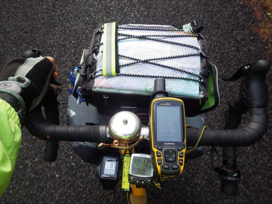
I have had pretty good luck with the routing on my Garmin GPS. It is a general recreation model, not specific to cycling. Model 64. When I tell it to go to a specific point, it asks me for a routing method, direct or straight line, automotive, motorcycle, bicycling, tour bicycling (this is more likely to take bike paths than the plain bicycling), mountain biking, pedestrian walking, hiking, mountaneering, and ATV/off roading. And when I pick tour cycling, it then asks me if I want to minimize time, distance or elevation.
When touring, if my route looks odd on the GPS map, like if it looks longer than I expected, I compare that routing to automotive routing. (If I am in a state where bicycles are prohibited from certain highways, I would not trust the automotive option very much.) Sometimes the automotive routing made more sense so I took that instead of tour bicycling routing.
But sometimes I liked the routing that the Android app Komoots or automotive routing on Maps.Me on my phone had, so took that instead of my Garmin GPS.
And sometimes if the local road on the paper map looks like it is better (for example, only half the distance), I might take that instead of the electronic routing.
I can't imagine why the depth of water would matter when you are bicyling. That said, a friend of mine complained after he submerged his dynohub when fording a stream, after which it had troubles. He said it was supposed to be waterproof, so he was upset about that.
07-29-20, 03:20 PM
#41
Senior Member
I can't imagine why the depth of water would matter when you are bicyling. That said, a friend of mine complained after he submerged his dynohub when fording a stream, after which it had troubles. He said it was supposed to be waterproof, so he was upset about that.
Easy to say as it wasnt me fording a waterway, but I think I'd always be inclined to remove all my bags and do multiple trips to keep the bike up above water.
but i wasnt there...
07-29-20, 04:15 PM
#42
Senior Member
Join Date: Aug 2010
Location: Madison, WI
Posts: 11,175
Bikes: 1961 Ideor, 1966 Perfekt 3 Speed AB Hub, 1994 Bridgestone MB-6, 2006 Airnimal Joey, 2009 Thorn Sherpa, 2013 Thorn Nomad MkII, 2015 VO Pass Hunter, 2017 Lynskey Backroad, 2017 Raleigh Gran Prix, 1980s Bianchi Mixte on a trainer. Others are now gone.
Mentioned: 47 Post(s)
Tagged: 0 Thread(s)
Quoted: 3452 Post(s)
Liked 1,452 Times
in
1,131 Posts
I dunno, but as someone who has always done my own hub maintenance, I would never intentionally submerge a hub, no matter what is said, and especially not with electronics involved.
Easy to say as it wasnt me fording a waterway, but I think I'd always be inclined to remove all my bags and do multiple trips to keep the bike up above water.
but i wasnt there...
Easy to say as it wasnt me fording a waterway, but I think I'd always be inclined to remove all my bags and do multiple trips to keep the bike up above water.
but i wasnt there...
07-30-20, 09:32 AM
#44
Senior Member
Join Date: Sep 2014
Posts: 646
Mentioned: 9 Post(s)
Tagged: 0 Thread(s)
Quoted: 184 Post(s)
Liked 36 Times
in
31 Posts
North Dakota
Thanks guys. I have toured before. I've also backpacked over 4000 miles. I do intend to look up route and take screen shots and keep the phone in airplane mode while riding so I'll be using the online copy only and not reliant on data. Nonetheless there still is the issue of days of riding through areas like North Dakota that will have no service whatsoever. Perhaps maps might serve me better in these areas. The issue of overheating that I'm referring to has nothing to do with overuse of phone and all to do with heat generated from the sun. Try putting your phone on a picnic table on a 90 degree sunny day where the sun is shining on it. Within 30 minutes the phone will overheat. This may be an argument for the handlebar bag instead. (Prior tours I've used maps.) And maybe you are correct that I am overestimating the necessity of needing my phone as a directional aide. Thanks.
07-30-20, 05:30 PM
#45
Senior Member
Join Date: Sep 2007
Location: Far beyond the pale horizon.
Posts: 14,254
Mentioned: 31 Post(s)
Tagged: 0 Thread(s)
Quoted: 4242 Post(s)
Liked 1,343 Times
in
932 Posts
Why do you keep spewing nonsense about things you clearly do not know much about?
???
People have been using digital topographical maps for years.
???
It's very unlikely that any paper maps the truck driver might have had would not have had enough elevation data. (It's not like truckers tend to use topo maps.) The paper maps people used to use tended to not have much detail.
???
"Recently printed" navigation charts are printed from digital sources. And have been for years.
???
People have been using digital topographical maps for years.
It's very unlikely that any paper maps the truck driver might have had would not have had enough elevation data. (It's not like truckers tend to use topo maps.) The paper maps people used to use tended to not have much detail.
"Recently printed" navigation charts are printed from digital sources. And have been for years.
Last edited by njkayaker; 07-30-20 at 05:41 PM.
07-30-20, 05:33 PM
#46
Senior Member
Join Date: Sep 2007
Location: Far beyond the pale horizon.
Posts: 14,254
Mentioned: 31 Post(s)
Tagged: 0 Thread(s)
Quoted: 4242 Post(s)
Liked 1,343 Times
in
932 Posts
I can't speak for every nook and cranny, but most of the state has coverage, depending on carrier. ATT shows amazing coverage, real world experience, it works fairly well most places. Verizon has better coverage overall. TMobile...only in metro areas, and along the interstate.
There's no reason to rely on it. Alternatives are very good and cheap.
Likes For njkayaker:

 07-31-20, 10:21 PM
#49
Senior Member
Join Date: May 2018
Location: Fargo ND
Posts: 898
Bikes: Time Scylon, Lynskey R350, Ritchey Breakaway, Ritchey Double Switchback, Lynskey Ridgeline, ICAN Fatbike
Mentioned: 2 Post(s)
Tagged: 0 Thread(s)
Quoted: 463 Post(s)
Liked 546 Times
in
306 Posts
We have toured Scotland and France depending on Google Maps and my phone (Moto G7 w/ Google Fi) for directions. I also have used that combo here in the US in several places. In all cases I have pre-loaded my map when I have WiFi access.
1) Water proof: I use an aluminum grabber mount and if it is raining I put the phone and case in a polyethylene (Baggie) bag. The touch works just fine.
2) Glare: I can cup my hand over the screen if the glare is really bad. Not sure if a polarized cover would work with my display or not. They can really screw up some displays. I just cup my hand over the display.
3) Heat: We rode in France with temperatures in the 90's. I have a solar charger and auxiliary battery pack to keep my phone going all day. No issues with heat. I have seen displays that would overheat from solar heating, but my Moto was just fine on a (for us) blistering hot French summer day.
4)Cellular coverage: Coverage in the Outer Hebrides two years ago was dismal at best. I loaded the entire region we were touring into Google Maps before we left the US. Not an issue. In rural France (Burgandy) I also downloaded the maps here in the US. No issues, except that the Google Bike routes were sometimes completely wacky. One put us on a single track mountain bike trail (and we were on a fully loaded touring tandem) when Euro Velo 6 was maybe 2 miles away.
In summary: my setup is a low to mid range phone on Google Fi with a $20 case, an aluminum phone mount. Mine is a Gub that is big enough to hold my phone in a case. I attached the mount with the headset preload bolt. I set the preload, tighten the stem clamp bolts, remove the stem preload bolt and mount the phone holder directly to the fork.
The advantage of my complete setup? It is cheap. Phone: $250, Mount: $20 Solar battery: $20 Baggie: $0.10 It has proven reliable. It is made of easily replaced parts. My GPS doubles as a phone and a camera.
07-31-20, 10:51 PM
#50
Senior Member
Join Date: Oct 2008
Location: Portland, OR
Posts: 3,831
Bikes: Trek Domane SL6 Gen 3, Soma Fog Cutter, Focus Mares AL, Detroit Bikes Sparrow FG, Volae Team, Nimbus MUni
Mentioned: 11 Post(s)
Tagged: 0 Thread(s)
Quoted: 892 Post(s)
Liked 2,048 Times
in
1,072 Posts
1) Waterproof phone case, waterproof phone, or a toptube bag with a clear waterproof phone section. Baggie & rubberband is an okay plan for a short ride, but not any multi-day. Baggies are not rugged. Plus in a surprise rain, covering the phone is just one more thing to deal with. Over that many days, you're going to forget it once. Finally, putting the phone IN a baggie, combined with a pinhole leak in the baggie, results in a bagful of phone and water.
2) If you have it aimed straight at your face, the hours/day when it's a problem will be minimal.
3) This, plus crashes, are IMO the two reasons to use a dedicated GPS rather than a phone for on-bar nav.
4) Verizon has the best coverage. No matter, you will have segments with no service. Offline maps are the key.

