


Bike Tour Montreal to Ogunquit
 03-02-19, 05:29 AM
#1
Junior Member
Thread Starter

Join Date: Mar 2019
Posts: 5
Mentioned: 0 Post(s)
Tagged: 0 Thread(s)
Quoted: 2 Post(s)
Likes: 0
Liked 0 Times
in
0 Posts
Bike Tour Montreal to Ogunquit
Hello,
I’m seriously considering a bike tour from Montreal QC to Ogunquit ME this July. This idea just came up yesterday when my family decided to start planning a group vacation to Ogunquit, I can meet them there and will have a ride back. Ideally I would camp most -if not all- of the way and hit somewhere between 80-120kms/day (depending on how mountainous the roads are amongst the other usual variables). I’m wondering if anyone has any suggestions on routes? Camping itineraries? Must-see stops along the way?
Thanks!
 03-02-19, 08:09 AM
#2
Senior Member
This is the route I have taken in the past from Montreal to northern NH entering the US at Frelighsburg QC. Not sure that Google maps has chosen the exact roads that I used through QC but those are the towns that I connected and roads that I used in VT and NH. State Park camping at Lake Carmi just across the border and again at Brighton State Park near Island Pond VT. More camping options at Twin Mt and Crawford Notch NH.
I've only cycled from here to Ogunquit once long ago. Don't remember the exact route we took. The Google suggestions look good on the roads chosen that I'm familiar with as far as Freedom NH. No experience with the remainder of their route beyond Freedom. Looks like a lot of quiet back roads perhaps with needless twists and turns that could be edited out.

https://goo.gl/V6vXD6
I've only cycled from here to Ogunquit once long ago. Don't remember the exact route we took. The Google suggestions look good on the roads chosen that I'm familiar with as far as Freedom NH. No experience with the remainder of their route beyond Freedom. Looks like a lot of quiet back roads perhaps with needless twists and turns that could be edited out.
https://goo.gl/V6vXD6
Last edited by BobG; 03-02-19 at 08:33 AM.
03-02-19, 09:13 AM
#3
Senior Member
I did Mtl to Boston about 5 years ago, pretty happy with the route, very nice ride in fact down through vermont. Can look at route specifics another time when I look out the papers.
In the meantime, look up the vermont bicycling route map pdf, its the pdf of a paper version that is found in all touristy areas/highway stops etc in the area, a nice map and very useful to have an idea of less busy highways.
I did in in july I think and there was a terrible heatwave for most of it, with 100f temps, so in the mid to high 30s, wasnt fun but better than cold and rain....
03-02-19, 11:48 AM
#4
Senior Member
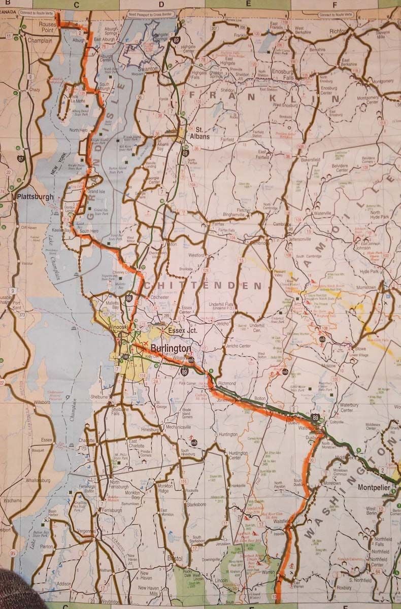
Here's the VT bike map that djb refers to. Scroll down for N VT...
https://www.vermontvacation.com/~/me...016.ashx?la=en
You can clearly see VT105 across the top that I followed marked as a bike route and the two state parks. I'd always ride down to Enosburg Falls to pick up groceries and loop back to Lake Carmi SP. There's not much in W Berkshire or E Franklin. Island Pond is convenient to Brighton SP for provisions. The route connects to VT102 at Bloomfield and follows the CT river to Lancaster NH.
edit: I see there is now a rail trail parallel to 105 from Enosburg Falls to Richford indicated by the red hash line. The Google map also utilizes it as seen when you zoom in...
Last edited by BobG; 03-03-19 at 07:40 AM.
03-04-19, 12:15 PM
#5
Senior Member
Join Date: Jan 2010
Posts: 39,230
Mentioned: 211 Post(s)
Tagged: 1 Thread(s)
Quoted: 18409 Post(s)
Liked 15,520 Times
in
7,324 Posts
Brighton State Park is nice. Heard and saw loons there in the morning. There was a relatively large grocery store in Island Pond when I was there in 2010.
Lake Carmi was decent as well.
Rode some of the southern/western section of that trail. Found it boring and a bit rough for skinny tires. Got back on the highway at Sheldon Jct. to get to Lake Carmi.
Lake Carmi was decent as well.
Rode some of the southern/western section of that trail. Found it boring and a bit rough for skinny tires. Got back on the highway at Sheldon Jct. to get to Lake Carmi.
03-08-19, 07:02 PM
#6
Senior Member
so Montreal dude, are you alive, toujours vivant?
If you are and interested, get back, participate and put down some of your ideas.
Getting a ride back is great, buses and trains are pretty darn time consuming, especially with the border crossings.
If you are and interested, get back, participate and put down some of your ideas.
Getting a ride back is great, buses and trains are pretty darn time consuming, especially with the border crossings.
03-12-19, 09:37 PM
#7
Junior Member
Thread Starter
Join Date: Mar 2019
Posts: 5
Mentioned: 0 Post(s)
Tagged: 0 Thread(s)
Quoted: 2 Post(s)
Likes: 0
Liked 0 Times
in
0 Posts

Thanks for the feedback! I’m hoping to avoid both the Green Mountains and White Mountains, would anyone consider travelling through Lebanon, VT or just south of White Mtns? I never really trust Google maps, but I’m hoping there’s some truth to the rideability and topography if I head cross the border east of Jay Peak and ride south through Greensboro, then Cabot to Plymouth. Might be a good way to keep the ride flat-ish?
03-12-19, 09:46 PM
#8
Junior Member
Thread Starter
Join Date: Mar 2019
Posts: 5
Mentioned: 0 Post(s)
Tagged: 0 Thread(s)
Quoted: 2 Post(s)
Likes: 0
Liked 0 Times
in
0 Posts
[QUOTE=BobG;20818800]This is the route I have taken in the past from Montreal to northern NH entering the US at Frelighsburg QC. Not sure that Google maps has chosen the exact roads that I used through QC but those are the towns that I connected and roads that I used in VT and NH. State Park camping at Lake Carmi just across the border and again at Brighton State Park near Island Pond VT. More camping options at Twin Mt and Crawford Notch NH.
I've only cycled from here to Ogunquit once long ago. Don't remember the exact route we took. The Google suggestions look good on the roads chosen that I'm familiar with as far as Freedom NH. No experience with the remainder of their route beyond Freedom. Looks like a lot of quiet back roads perhaps with needless twists and turns that could be edited out.
————
this looks like a nice route, oddly enough not the one Google suggested me. As much as I’m interested in heading through the White mtns, I’m wondering how tough they might be fully loaded? Not totally opposed, just mildly concerned!
03-13-19, 05:38 AM
#9
Senior Member
Join Date: Apr 2014
Location: Maine, USA
Posts: 1,612
Bikes: Corvid Sojourner, Surly Ice Cream Truck, Co-Motion Divide, Co-Motion Java Tandem, Salsa Warbird, Salsa Beargrease, Carver Tandem
Mentioned: 3 Post(s)
Tagged: 0 Thread(s)
Quoted: 534 Post(s)
Liked 435 Times
in
227 Posts
I have never done this particular ride but we live very close to Ogunquit and have done numerous trips to Montreal when our son was a student there. I also know the Maine and New Hampshire locations very well.
If I were planning this I would most likely go north, take advantage of the great bicycle paths in the Magog region and cross the border near Grafton Notch ... this would take me a little bit out of the beaten path and give me good opportunity to camp along the way. This google route shows what I'm thinking but I would then improve the details by routing myself onto the Rue Verte trails and also take advantage of the Eastern Trail in Maine. Something like this
You will have chances to camp in outdoor regions along Magog, Grafton Notch, rt35 between Bethel and Naples and Sebago Lake State Park
And this google route suggestion seems to have the least vert. I would still improve the details though.
Last edited by PedalingWalrus; 03-13-19 at 05:43 AM.
03-13-19, 05:41 AM
#10
Senior Member
The top of VT is across the grain with some climbs then it's rolling terrain down the CT river to Lancaster NH. Crawford Notch NH southbound is fairly tame. Back in my younger days it would be 3-4 days Montreal to Jackson, 1 day Jackson to Ogunquit. Some short steep hills through ME but you're out of the mountains.
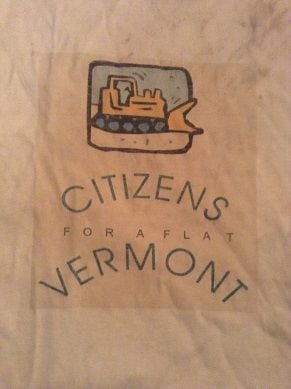
Just a suggestion of a route I like that is scenic and low traffic. Hundreds of other options. Not sure if flat is possible anywhere in VT. This T shirt says it all. It was a gift to all of the staff of an ACA "Cycle VT" tour from a participant at its conclusion.
 ...
...

Last edited by BobG; 03-13-19 at 10:38 AM. Reason: change Crawford Notch info to apply to your southbound travel
03-13-19, 06:31 AM
#11
Senior Member
Really look at your elevation profiles. Most of the upper sections of NH and VT are REALLY hilly. Pedaled plenty of those states. Fan of bike paths? Check out rails to trails.com. Also the east coast greenway esp. coming south of Portland. Nice pedaling there. Those bike paths are old rail ways, ie mostly flat. Also check out route on map my ride and ride with gps. Did the cross NH trail last summer. More dirt than you may like. Please post back, lots of options available. The VT and NH sate parks for camping are good, $25 ish with showers.
03-13-19, 07:25 AM
#12
Senior Member
mellow, glad you reappeared. I wasnt going to make the effort to find my notes and maps and stuff until you did.
Will look for the details over the weekend. I know the route I did wasnt too bad for climbing, a few longish climbs but this is normal because of the terrain, and it was all doable, and really very pretty for the most part.
Riding in hilly areas does involve more work, but if your bikes gearing is appropriate, it can work, and the changing views and downhills are so much fun.
I am assuming your bike has proper gearing for what weight you'll be carrying.
Have you toured with camping stuff on your bike before, with climbing involved?
What bike?
As I'm sure you know, the great thing with having Mont Royal here is that it's a great place to load up your bike and do loops going over and around the mountain to get used to climbing on a heavy bike. Camillien Houde is somewhere around 10-12%, I forget, but is great training for riding loaded--its pretty important to ride loaded beforehand, you'll get stronger and depending on your bike, it will show if your bike doesnt have low enough gearing.
I've done lots of loaded touring, so thats why I ask what bike and about how heavy the load, to at least give you an idea of how your bike is gearing wise for what you want to do.
oh, is all this blah blah in English ok, or be better in French?
03-14-19, 02:39 PM
#13
Junior Member
Thread Starter
Join Date: Mar 2019
Posts: 5
Mentioned: 0 Post(s)
Tagged: 0 Thread(s)
Quoted: 2 Post(s)
Likes: 0
Liked 0 Times
in
0 Posts
Really look at your elevation profiles. Most of the upper sections of NH and VT are REALLY hilly. Pedaled plenty of those states. Fan of bike paths? Check out rails to trails.com. Also the east coast greenway esp. coming south of Portland. Nice pedaling there. Those bike paths are old rail ways, ie mostly flat. Also check out route on map my ride and ride with gps. Did the cross NH trail last summer. More dirt than you may like. Please post back, lots of options available. The VT and NH sate parks for camping are good, $25 ish with showers.
03-14-19, 02:49 PM
#14
Junior Member
Thread Starter
Join Date: Mar 2019
Posts: 5
Mentioned: 0 Post(s)
Tagged: 0 Thread(s)
Quoted: 2 Post(s)
Likes: 0
Liked 0 Times
in
0 Posts
mellow, glad you reappeared. I wasnt going to make the effort to find my notes and maps and stuff until you did.
Will look for the details over the weekend. I know the route I did wasnt too bad for climbing, a few longish climbs but this is normal because of the terrain, and it was all doable, and really very pretty for the most part.
Riding in hilly areas does involve more work, but if your bikes gearing is appropriate, it can work, and the changing views and downhills are so much fun.
I am assuming your bike has proper gearing for what weight you'll be carrying.
Have you toured with camping stuff on your bike before, with climbing involved?
What bike?
As I'm sure you know, the great thing with having Mont Royal here is that it's a great place to load up your bike and do loops going over and around the mountain to get used to climbing on a heavy bike. Camillien Houde is somewhere around 10-12%, I forget, but is great training for riding loaded--its pretty important to ride loaded beforehand, you'll get stronger and depending on your bike, it will show if your bike doesnt have low enough gearing.
I've done lots of loaded touring, so thats why I ask what bike and about how heavy the load, to at least give you an idea of how your bike is gearing wise for what you want to do.
oh, is all this blah blah in English ok, or be better in French?
Will look for the details over the weekend. I know the route I did wasnt too bad for climbing, a few longish climbs but this is normal because of the terrain, and it was all doable, and really very pretty for the most part.
Riding in hilly areas does involve more work, but if your bikes gearing is appropriate, it can work, and the changing views and downhills are so much fun.
I am assuming your bike has proper gearing for what weight you'll be carrying.
Have you toured with camping stuff on your bike before, with climbing involved?
What bike?
As I'm sure you know, the great thing with having Mont Royal here is that it's a great place to load up your bike and do loops going over and around the mountain to get used to climbing on a heavy bike. Camillien Houde is somewhere around 10-12%, I forget, but is great training for riding loaded--its pretty important to ride loaded beforehand, you'll get stronger and depending on your bike, it will show if your bike doesnt have low enough gearing.
I've done lots of loaded touring, so thats why I ask what bike and about how heavy the load, to at least give you an idea of how your bike is gearing wise for what you want to do.
oh, is all this blah blah in English ok, or be better in French?
hahaha I’m Anglo, but I guess most of us Montréalers do the frenglish so I’m good either way! I’m not involved much in bike culture so I probably lack official cycling language however lol! Thank for looking into your route. I’m a reasonably experienced tourer, I put in around 5000kms every year with commuting and touring. I ride a Kona Sutra that has a granny gear that I’ve used often. I did a trip across Ontario a about 6 years ago with all my camping gear and my dog (65 lb husky) in tow. It was my first tour and I was hooked. He has a nice Burley buggy so he didn’t have to do any mushing himself. Since then only shorter weekend trips, but my work commute is ~40kms/day which I hope to start next week, so I’ll be touring-ready by summer.
That being said; I’ve put on some weight this year and age is catching up (my 40s aren’t my 30s) so I’m thinking I’ll have to be realistic with my goals.
03-14-19, 04:39 PM
#15
Senior Member
Mellow,
Your proposed route from Canada > Greensboro > Cabot > Plymouth should be fun also. If you take the route to to Lebanon there is a 50+ mile rail trail that continues across NH as far as Boscawen. You'd be on your own from there to Ogunquit...
https://fnrt.org
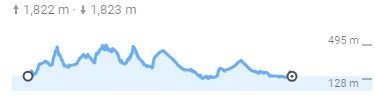
That said, the profile through VT looks scary. Less elevation gain than my route through Crawford Notch but continuous ups and downs the whole way. Canada to Plymouth NH...
BobG
Executive VP
Citizens For A Flat Vermont
edit: The default Google route to Plymouth takes a nasty section of US 302. It does utilize a parallel rail trail where possible. The map to Lebanon is better. Best to use Google as a general guideline and refer to djb's suggested bike routes map above.
Your proposed route from Canada > Greensboro > Cabot > Plymouth should be fun also. If you take the route to to Lebanon there is a 50+ mile rail trail that continues across NH as far as Boscawen. You'd be on your own from there to Ogunquit...
https://fnrt.org
That said, the profile through VT looks scary. Less elevation gain than my route through Crawford Notch but continuous ups and downs the whole way. Canada to Plymouth NH...
BobG
Executive VP
Citizens For A Flat Vermont
edit: The default Google route to Plymouth takes a nasty section of US 302. It does utilize a parallel rail trail where possible. The map to Lebanon is better. Best to use Google as a general guideline and refer to djb's suggested bike routes map above.
Last edited by BobG; 03-15-19 at 06:08 AM.
03-14-19, 05:49 PM
#16
Senior Member
hahaha I’m Anglo, but I guess most of us Montréalers do the frenglish so I’m good either way! I’m not involved much in bike culture so I probably lack official cycling language however lol! Thank for looking into your route. I’m a reasonably experienced tourer, I put in around 5000kms every year with commuting and touring. I ride a Kona Sutra that has a granny gear that I’ve used often. I did a trip across Ontario a about 6 years ago with all my camping gear and my dog (65 lb husky) in tow. It was my first tour and I was hooked. He has a nice Burley buggy so he didn’t have to do any mushing himself. Since then only shorter weekend trips, but my work commute is ~40kms/day which I hope to start next week, so I’ll be touring-ready by summer.
That being said; I’ve put on some weight this year and age is catching up (my 40s aren’t my 30s) so I’m thinking I’ll have to be realistic with my goals.
I hear you on being realistic, although touch wood, my 50s dont feel too different than my 40s, but maybe I'm just kidding myself!
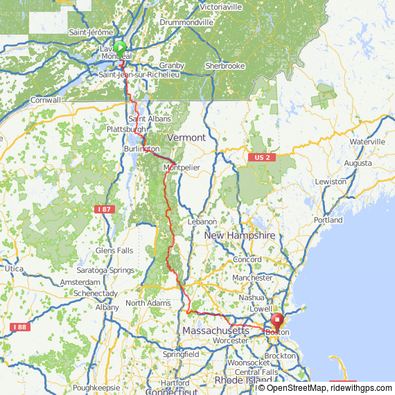
I just looked and found my notes and stuff, took some photos of the maps, but then found this, which my travelling companion from that trip did afterwards, it gives an overview of the route.
If you have specific route questions, ask away. I do remember route 100 going down Vermont to be really pretty nearly the whole time.
We did Mtl over the Estacade, followed the seaway path thing to St Catherine, then small country roads down to the top of lake champlain. Stayed near there just over the border at a place of someone I knew, then next day down the lake champlain islands, pretty ride, to Burlington. Then from there, over a bit and then down the 100.
as you plan to end up further north of boston, my route probably would go too far south, but perhaps it can give an idea anyway.
I think this trip is worth the effort, if you can fit it in time wise, this area is really nice riding, I reckon the best thing is to get accurate info on how much climbing there will be in certain areas.
I'm sure with some playing around with google maps, you can get an idea of altitude gain climbing for various route options

. At this time in 2013, I had never used google maps, but in the last few years, I've used it more, a big help with seeing roughly how many meters of climbing in a day, especially when I did my Latin American trips, helps with planning realistic distances and time riding.
you're not planning to pull the Burley are you?

 03-21-19, 10:42 AM
#17
Senior Member

Join Date: Jun 2016
Location: Boston Roads
Posts: 975
Bikes: 2012 Canondale Synapse 105, 2017 REI Co-Op ADV 3.1
Mentioned: 14 Post(s)
Tagged: 0 Thread(s)
Quoted: 507 Post(s)
Liked 237 Times
in
133 Posts
If I may pitch in, Quebec tourist information bureau has good information on cycling routes. I'm not sure what the central point is but maybe this can be a start
Le guide des pistes cyclables au Québec avec cartes, photos, commentaires, description, services, évaluation
https://tourisme.val-saint-francois.c...-2016-2018.pdf
https://www.routeverte.com/en/discov...nch%3Dnetworks
Le guide des pistes cyclables au Québec avec cartes, photos, commentaires, description, services, évaluation
https://tourisme.val-saint-francois.c...-2016-2018.pdf
https://www.routeverte.com/en/discov...nch%3Dnetworks

