


The OC - Mountains to the Sea Trail - ??
 10-24-09, 07:16 PM
#1
Senior Member
Thread Starter
Join Date: Aug 2008
Location: San Juan Islands of WA & Newport Beach, CA
Posts: 469
Bikes: HP Velotechnik Scorpion FS trike, Specialized FSRxc Expert, Swissbike LX folding hardtail, Dahon Speed 7 folder
Mentioned: 0 Post(s)
Tagged: 0 Thread(s)
Quoted: 3 Post(s)
Likes: 0
Liked 0 Times
in
0 Posts
The OC - Mountains to the Sea Trail - ??
Hi,
Down for the winter and looking at the OC rides - nice paved bike trails suitable for a Geezer. You can have the San Juan Islands from November to May. There is a reason they are green. Water. Lots of water, falling from the sky. Actually - usually blowing sideways. Moab in October, then in for the winter works for me.
@@@
I am wondering if the Mountains to the Sea Trail is all Class 1/ No cars from start to finish.
Looking at the OCTA map on line, it appears to be that from the Back Bay into Tustin, then share the ride. I know it's paved up to Bill Barber Park. Just road San Diego Ck to 133.
Not sure how up to date the map is. The one on the bike must be 5 yrs back.
@@@ A loop...
The map indicates I can take the SDC trail to Jeffrey, then head back towards University on a bike path, thence to rejoin SDC. Truth?
 10-24-09, 08:12 PM
#2
Grammar Cop

Join Date: Jan 2008
Location: Papa Smurf's Lair
Posts: 1,543
Bikes: in my sig line
Mentioned: 0 Post(s)
Tagged: 0 Thread(s)
Quoted: 1 Post(s)
Likes: 0
Liked 3 Times
in
3 Posts
You watch too much television. No one outside of that TV show actually calls it "The OC." No one. Certainly no one who actually lives in Orange County.
There's no way to do any kind of loop without going onto the streets. Part of the Mountains to the Sea Trail is blocked and you'll have to divert onto streets to continue along. Part of it is MUP alongside streets, so you're dealing with cross streets. And, of course, the Back Bay portion(s) are shared road.
There's no way to do any kind of loop without going onto the streets. Part of the Mountains to the Sea Trail is blocked and you'll have to divert onto streets to continue along. Part of it is MUP alongside streets, so you're dealing with cross streets. And, of course, the Back Bay portion(s) are shared road.
10-24-09, 11:18 PM
#3


Pedal pusher...

Join Date: Oct 2006
Location: Los Angeles
Posts: 7,766
Bikes: I've got a bunch...
Mentioned: 0 Post(s)
Tagged: 0 Thread(s)
Quoted: 5 Post(s)
Liked 0 Times
in
0 Posts
Condorita is it a nice ride?
__________________
May you live long, live strong, and live happy!
May you live long, live strong, and live happy!
10-24-09, 11:36 PM
#4
Senior Member

Join Date: Sep 2009
Location: Santa Ana
Posts: 229
Mentioned: 0 Post(s)
Tagged: 0 Thread(s)
Quoted: 0 Post(s)
Likes: 0
Liked 0 Times
in
0 Posts
well there the Santa Ana river Trail.... which is really nice ride....
https://www.nearfield.com/~dan/sports...r/sa/index.htm
https://www.nearfield.com/~dan/sports...r/sa/index.htm
10-25-09, 01:23 PM
#5
Shredding Grandma!

Join Date: Jun 2006
Location: So Cal
Posts: 4,803
Bikes: I don't own any bikes
Mentioned: 0 Post(s)
Tagged: 0 Thread(s)
Quoted: 46 Post(s)
Likes: 0
Liked 0 Times
in
0 Posts
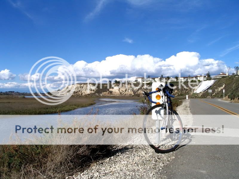
Mountain to Sea trail... It's an interesting combination of mountain bike trail to bike path with some street thrown in but frankly is one of my favorites especially if you start say in North Irvine, get on the trail around Bryan or Irvine Bld and take it down and around Back Bay (which basically becomes the San Diego Creek Trail). The basic bike trail goes by alot of nice ecenary, is a favorite of many riders (so watch out for riders and pedesterian traffic). If you need some direction let me know.
Here's a photo from Back Bay:
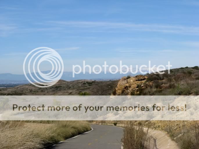
To extend the ride you can connect at some point to the Shady Ridge trail:
Edited to add: No way to totally avoid cars because some street is involved (they have not yet finished the entire bike path) but the streets are quiet. Back Bay allows some car traffic but it si one way and speed limit I believe 15 mps. Bikes go faster!!!
Here's a photo from Back Bay:
To extend the ride you can connect at some point to the Shady Ridge trail:
Edited to add: No way to totally avoid cars because some street is involved (they have not yet finished the entire bike path) but the streets are quiet. Back Bay allows some car traffic but it si one way and speed limit I believe 15 mps. Bikes go faster!!!
__________________
 ______________________________________________________________
Private docent led mountain bike rides through Limestone Canyon. Go to letsgooutside.org and register today! Also available: hikes, equestrian rides and family events as well as trail maintenance and science study.
______________________________________________________________Private docent led mountain bike rides through Limestone Canyon. Go to letsgooutside.org and register today! Also available: hikes, equestrian rides and family events as well as trail maintenance and science study.
Last edited by Pamestique; 10-26-09 at 08:21 PM.
10-26-09, 07:01 PM
#6
Senior Member
Thread Starter
Join Date: Aug 2008
Location: San Juan Islands of WA & Newport Beach, CA
Posts: 469
Bikes: HP Velotechnik Scorpion FS trike, Specialized FSRxc Expert, Swissbike LX folding hardtail, Dahon Speed 7 folder
Mentioned: 0 Post(s)
Tagged: 0 Thread(s)
Quoted: 3 Post(s)
Likes: 0
Liked 0 Times
in
0 Posts
[QUOTE=Condorita;9919209]You watch too much television. No one outside of that TV show actually calls it "The OC." No one. Certainly no one who actually lives in Orange County.
@@@
There is always an exception. Been paying property taxes to the OC tax collectors since 1962.
Remember Bob Citron? OC Bankrupt, etc.? When John Wayne was a sleepy little airport. I do. Good ole days.
@@@
There is always an exception. Been paying property taxes to the OC tax collectors since 1962.
Remember Bob Citron? OC Bankrupt, etc.? When John Wayne was a sleepy little airport. I do. Good ole days.
10-26-09, 07:37 PM
#7
Senior Member
Thread Starter
Join Date: Aug 2008
Location: San Juan Islands of WA & Newport Beach, CA
Posts: 469
Bikes: HP Velotechnik Scorpion FS trike, Specialized FSRxc Expert, Swissbike LX folding hardtail, Dahon Speed 7 folder
Mentioned: 0 Post(s)
Tagged: 0 Thread(s)
Quoted: 3 Post(s)
Likes: 0
Liked 0 Times
in
0 Posts
well there the Santa Ana river Trail.... which is really nice ride....
https://www.nearfield.com/~dan/sports...r/sa/index.htm
https://www.nearfield.com/~dan/sports...r/sa/index.htm
Did the beach ride from NB to Sunset Beach. Went to park at a state beach. They wanted $15 day use fee. @#$% that. For that I expect a campsite. Did not get the money. Went down to NB, took the first beach access sign, parked for free alongside a park. Yes, I know: Try that (1) on a weekend, (2) during summer, etc.
No wonder this state is bankrupt. No brains on high. If I had miles of underused parking space, I'd be running winter rates, discount days, coupon books, what ever it took to get more cars in the lot. It's like an air line. If that seat or parking space is empty, that is money you will never see. However, your fixed costs will continue.
10-26-09, 07:41 PM
#8
Senior Member
Thread Starter
Join Date: Aug 2008
Location: San Juan Islands of WA & Newport Beach, CA
Posts: 469
Bikes: HP Velotechnik Scorpion FS trike, Specialized FSRxc Expert, Swissbike LX folding hardtail, Dahon Speed 7 folder
Mentioned: 0 Post(s)
Tagged: 0 Thread(s)
Quoted: 3 Post(s)
Likes: 0
Liked 0 Times
in
0 Posts
Nice pix. Winter in the back bay? Shady Ridge Trail looks interesting. Have to look that one up. (I did. It's back east. This must be a long lost cousin.) Where does it start? Where does it go. Looks like up in the hills.
10-26-09, 08:21 PM
#9
Shredding Grandma!
Join Date: Jun 2006
Location: So Cal
Posts: 4,803
Bikes: I don't own any bikes
Mentioned: 0 Post(s)
Tagged: 0 Thread(s)
Quoted: 46 Post(s)
Likes: 0
Liked 0 Times
in
0 Posts
The Back Bay photo was in November.
__________________
______________________________________________________________
Private docent led mountain bike rides through Limestone Canyon. Go to letsgooutside.org and register today! Also available: hikes, equestrian rides and family events as well as trail maintenance and science study.
______________________________________________________________Private docent led mountain bike rides through Limestone Canyon. Go to letsgooutside.org and register today! Also available: hikes, equestrian rides and family events as well as trail maintenance and science study.
11-02-09, 11:58 AM
#10
Member
Join Date: Aug 2009
Location: Franklin, TN
Posts: 37
Bikes: Alchemy Helios
Mentioned: 0 Post(s)
Tagged: 0 Thread(s)
Quoted: 0 Post(s)
Likes: 0
Liked 2 Times
in
2 Posts
The Mountains to the Sea Trail is indeed a beautiful ride, and at least the southern portion (near the sea) is dedicated bike trail. That doesn't mean it's without its hazards, however. I came upon an accident on the trail this weekend, where a kid (maybe 6 or 7) pulled onto the trail from behing a hedge, without looking, causing the guy heading northbound to take evasive maneuvers and fly ass-over-teakettle onto the tarmac. The rider did his absolute best not to get mad at the kid, or his grandfather, who was trying to help in the aftermath. Bravo, rider, whoever you are.
Let's be careful out there.
Let's be careful out there.
11-02-09, 01:37 PM
#11
Senior Member
Join Date: Oct 2007
Location: costa mesa, ca
Posts: 719
Mentioned: 0 Post(s)
Tagged: 0 Thread(s)
Quoted: 1 Post(s)
Likes: 0
Liked 0 Times
in
0 Posts
If I had miles of underused parking space, I'd be running winter rates, discount days, coupon books, what ever it took to get more cars in the lot. It's like an air line. If that seat or parking space is empty, that is money you will never see. However, your fixed costs will continue.
I've watched the City of HB plant palm trees, grass and upgrade the amenities to improve the beach area around the pier and south towards Newport. It works. The place looks like a fun place to hang out and have a day at the beach. Biking, surfing walking...it's a good place to start a day.
The state beach at Bolsa is an embarassment - and it will probably roll on as it is...bleak, but a cheap place to hang out - just don't expect much.
11-02-09, 04:04 PM
#12
Grammar Cop
Join Date: Jan 2008
Location: Papa Smurf's Lair
Posts: 1,543
Bikes: in my sig line
Mentioned: 0 Post(s)
Tagged: 0 Thread(s)
Quoted: 1 Post(s)
Likes: 0
Liked 3 Times
in
3 Posts
Remember Bob Citron? OC Bankrupt, etc.? When John Wayne was a sleepy little airport. I do. Good ole days.
11-02-09, 07:05 PM
#13
Senior Member
Thread Starter
Join Date: Aug 2008
Location: San Juan Islands of WA & Newport Beach, CA
Posts: 469
Bikes: HP Velotechnik Scorpion FS trike, Specialized FSRxc Expert, Swissbike LX folding hardtail, Dahon Speed 7 folder
Mentioned: 0 Post(s)
Tagged: 0 Thread(s)
Quoted: 3 Post(s)
Likes: 0
Liked 0 Times
in
0 Posts
Shady Ridge - out of Turtle Rock. Either starts at Sand Canyon (Quail Hill) just south of the 405 or from Culver/Bonita Canyon to Shady Hill, take the bike path through Bommer Canyon and connect to the bike path (shady Ridge) behind the gated community. I took that photo Christmas day two years ago. It's a beautiful rolling ride behind Turtle Rock to Irvine.
The Back Bay photo was in November.
The Back Bay photo was in November.
@@@
Checked the towns in S. county for bike trails. Aside from mt. bike trails, no joy. On street lanes. Credit to Irvine.
11-02-09, 07:07 PM
#14
Senior Member
Thread Starter
Join Date: Aug 2008
Location: San Juan Islands of WA & Newport Beach, CA
Posts: 469
Bikes: HP Velotechnik Scorpion FS trike, Specialized FSRxc Expert, Swissbike LX folding hardtail, Dahon Speed 7 folder
Mentioned: 0 Post(s)
Tagged: 0 Thread(s)
Quoted: 3 Post(s)
Likes: 0
Liked 0 Times
in
0 Posts
When people were in an uproar because Anaheim Stadium was out in the boonies? Grunion running at Huntington? Garden Grove to Huntington Beach down Brookhurst in a matter of minutes because once you got to about Edinger there were only a couple of signals left? The helicopter collision over Mile Square Park? Riding my bicycle on the under-construction Garden Grove Freeway? When Garden Grove was more strawberry fields than houses?
When there were orange groves in Orange County?
11-02-09, 11:26 PM
#15
Senior Member
Thread Starter
Join Date: Aug 2008
Location: San Juan Islands of WA & Newport Beach, CA
Posts: 469
Bikes: HP Velotechnik Scorpion FS trike, Specialized FSRxc Expert, Swissbike LX folding hardtail, Dahon Speed 7 folder
Mentioned: 0 Post(s)
Tagged: 0 Thread(s)
Quoted: 3 Post(s)
Likes: 0
Liked 0 Times
in
0 Posts
Re - Shady Ridge Trail
Believe I found it on Google E. Starts at intersection of Culver/Anteater/Bonita Cyn and wanders over to Quail Hill. Is there really a trail head at QH? Irvine bike map shows one. But an actual trail head on an Irvine trail is something I have not seen. GE is not clear. Might be something under construction. Usually, find the nearest park for parking.
When I was doing the Jeffrey Rd/University loop back off San Diego Creek, there was a bike trail heading S. along the freeway beyond the 405 overpass. Does it connect to Quail Hill? Looks like it on GE.
Anything going up Culver from Wm. Mason Park on Univ. to make a loop? GE shows something, but looks under construction.
11-03-09, 02:43 AM
#16
Senior Member
Join Date: Feb 2009
Posts: 911
Mentioned: 0 Post(s)
Tagged: 0 Thread(s)
Quoted: 3 Post(s)
Likes: 0
Liked 2 Times
in
2 Posts
There are a few off road paved trails in South OC. Aliso Ck, San Juan Ck. And some others. There's another up from Salt Creek into Dana Point.
Go to the OCTA website and find the bikeways map.
There really is a TH in Quail Hill. It's just past the first traffic circle on the right south on Shady Canyon from the 405. It's got plenty of room.
The trail from Jeffrey and the newer freeway overpass does connect to the QH TH.
From Mason park if you were to diagonally cross Harvard/Culver you hit the San Diego Ck Trail. Little entrance next to the churches. Makes a good loop connecting to all the others in Irvine.
There's also a small network of trails in Turtle Rock that connects to the Mason Park system. (And the Shady Canyon trail)
There is also the ped/bike bridge over 405 on Yale.
Lots of possibilities for loops over there.
11-03-09, 08:17 AM
#17
Shredding Grandma!
Join Date: Jun 2006
Location: So Cal
Posts: 4,803
Bikes: I don't own any bikes
Mentioned: 0 Post(s)
Tagged: 0 Thread(s)
Quoted: 46 Post(s)
Likes: 0
Liked 0 Times
in
0 Posts
Re - Shady Ridge Trail
Believe I found it on Google E. Starts at intersection of Culver/Anteater/Bonita Cyn and wanders over to Quail Hill. Is there really a trail head at QH? Irvine bike map shows one. But an actual trail head on an Irvine trail is something I have not seen. GE is not clear. Might be something under construction. Usually, find the nearest park for parking.
When I was doing the Jeffrey Rd/University loop back off San Diego Creek, there was a bike trail heading S. along the freeway beyond the 405 overpass. Does it connect to Quail Hill? Looks like it on GE.
Anything going up Culver from Wm. Mason Park on Univ. to make a loop? GE shows something, but looks under construction.
Believe I found it on Google E. Starts at intersection of Culver/Anteater/Bonita Cyn and wanders over to Quail Hill. Is there really a trail head at QH? Irvine bike map shows one. But an actual trail head on an Irvine trail is something I have not seen. GE is not clear. Might be something under construction. Usually, find the nearest park for parking.
When I was doing the Jeffrey Rd/University loop back off San Diego Creek, there was a bike trail heading S. along the freeway beyond the 405 overpass. Does it connect to Quail Hill? Looks like it on GE.
Anything going up Culver from Wm. Mason Park on Univ. to make a loop? GE shows something, but looks under construction.
__________________
______________________________________________________________
Private docent led mountain bike rides through Limestone Canyon. Go to letsgooutside.org and register today! Also available: hikes, equestrian rides and family events as well as trail maintenance and science study.
______________________________________________________________Private docent led mountain bike rides through Limestone Canyon. Go to letsgooutside.org and register today! Also available: hikes, equestrian rides and family events as well as trail maintenance and science study.
11-09-09, 05:48 PM
#18
Senior Member
Thread Starter
Join Date: Aug 2008
Location: San Juan Islands of WA & Newport Beach, CA
Posts: 469
Bikes: HP Velotechnik Scorpion FS trike, Specialized FSRxc Expert, Swissbike LX folding hardtail, Dahon Speed 7 folder
Mentioned: 0 Post(s)
Tagged: 0 Thread(s)
Quoted: 3 Post(s)
Likes: 0
Liked 0 Times
in
0 Posts
There really is a TH in Quail Hill. It's just past the first traffic circle on the right south on Shady Canyon from the 405. It's got plenty of room.
@@@ Sure is. Was out there yesterday. It's a lovely project. I would put it right up there with Anmar Station on the Centennial Trail (of Snohomish County, WA)
Are there any more such in Irvine? Actual trailheads with parking and facilities seem to be scarce on urban trails. The closest park seems to serve that need.
The trail from Jeffrey and the newer freeway overpass does connect to the QH TH.
@@@ Got pix of the signage. When will they extend the Sand Canyon trail down to that overpass? It is built to take a trail coming in from either side.
From Mason park if you were to diagonally cross Harvard/Culver you hit the San Diego Ck Trail. Little entrance next to the churches. Makes a good loop connecting to all the others in Irvine.
@@@ Know it. I came up it from the Back Bay. They stock that barranca with lions?
What are they doing in the wetland portion with that grading? Putting in parking? Sorta looks like that.
Went up to find the QH trailhead, then back down, over the JRd. OP to San Diego CK and back home that way.
There's also a small network of trails in Turtle Rock that connects to the Mason Park system. (And the Shady Canyon trail)
@@@ I better Google E on T Rock.
There is also the ped/bike bridge over 405 on Yale.
@@@ Went whizzing under that yesterday, thinking - doesn't look like the Jeffrey Rd OP. Need a closer look at the options there.
Tnx for the input. Irvine certainly has a fine system of Class I trails. Newport Beach - not much of anything aside from the Back Bay Loop. (I do not like to play with cars. Odds are not in my favor.) I can spend the winter exploring the Class I trails around here and then off again to the rail trails come summer.
Lots of possibilities for loops over there.
