


Long continuous climb routes?
 04-15-23, 10:12 AM
#1
Senior Member
Thread Starter

Join Date: Mar 2020
Location: Nevada County, California
Posts: 790
Bikes: Subject to change at any given moment but currently is...... Colnago Mapei, Colnago C40, Wilier Triestina Carbon, Wilier Triestina Ramato, Follis 472, Peugeot PX60, Razesa, Orbea Terra, Soma Pescadero and 1/2 owner of a Santana tandem.
Mentioned: 2 Post(s)
Tagged: 0 Thread(s)
Quoted: 336 Post(s)
Liked 782 Times
in
264 Posts
Long continuous climb routes?
I did a great 30 mile ride yesterday that featured a 12 mile continuous climb of over 3700’. Can anyone tell me of any climbs exceeding that in the N Ca area? I’m only interested in pure continuous climbs that at no point descend even briefly.
Cheers !
Cheers !
 04-15-23, 10:41 AM
#2
Senior Member
Join Date: May 2017
Location: Hacienda Hgts
Posts: 2,109
Bikes: 1999 Schwinn Peloton Ultegra 10, Kestrel RT-1000 Ultegra, Trek Marlin 6 Deore 29'er
Mentioned: 3 Post(s)
Tagged: 0 Thread(s)
Quoted: 823 Post(s)
Liked 1,961 Times
in
944 Posts
Mt Shasta
https://ridewithgps.com/routes/6584324
https://ridewithgps.com/routes/6584324
Likes For CAT7RDR:
04-15-23, 11:06 AM
#3
ignominious poltroon

Join Date: Jan 2022
Posts: 4,051
Mentioned: 3 Post(s)
Tagged: 0 Thread(s)
Quoted: 2244 Post(s)
Liked 3,445 Times
in
1,804 Posts
There is a website devoted to answering this question: https://pjammcycling.com
Likes For Polaris OBark:
04-15-23, 03:21 PM
#4
It's MY mountain

Join Date: Sep 2006
Location: Mt.Diablo
Posts: 10,002
Bikes: Klein, Merckx, Trek
Mentioned: 70 Post(s)
Tagged: 0 Thread(s)
Quoted: 4338 Post(s)
Liked 2,982 Times
in
1,618 Posts
Likes For DiabloScott:
04-15-23, 07:37 PM
#5
Senior Member

Join Date: Nov 2014
Location: Eugene, Oregon, USA
Posts: 27,547
Mentioned: 217 Post(s)
Tagged: 0 Thread(s)
Quoted: 18379 Post(s)
Liked 4,512 Times
in
3,354 Posts
Does Oregon count?
I'm not sure about the continuous, not even a brief reprieve.
Note, much of Crater Lake will be snowed in this time of year with NO access other than using skies.
Here is the "What Goes Up Must Come Down" ride. You can think of it backwards if you wish.
https://www.strava.com/activities/718263879
From Steamboat Oregon, Elevation: 1,155 feet up to Crater Lake, Elevation: 7,731 feet. Covering about a Metric Century.
While not completely monotonous, it is pretty unrelenting.
A little earlier in that ride, the road between Culp Creek Oregon to Steamboat Oregon was pretty intense, and almost devoid of cars. Combine these two segments.
https://www.strava.com/segments/28476750
https://www.strava.com/segments/1764946
The climb was most intense on the north side of the hill (loaded touring). But, longer and far more gradual on the south side of the hill.
The McKenzie Pass, HWY 242 is pretty good. Much longer and steeper from the West side than the East side. It is closed to all traffic this time of year, but bikes may be able to get through. It is probably best to head up there late May or early June after a long sunny week, especially with all the rain and snow we've gotten this year. But, get up there before it is opened to traffic.
https://www.strava.com/segments/4296595
Not super steep, but about 20 miles of climbing.
Likes For CliffordK:
04-15-23, 07:42 PM
#6
Senior Member
Join Date: Nov 2014
Location: Eugene, Oregon, USA
Posts: 27,547
Mentioned: 217 Post(s)
Tagged: 0 Thread(s)
Quoted: 18379 Post(s)
Liked 4,512 Times
in
3,354 Posts
Oh, if you get tired of RAINY CALIFORNIA, I've heard that Mauna Kea, Hawaii is supposed to be quite spectacular.
04-15-23, 08:10 PM
#7
Senior Member
Join Date: Oct 2014
Location: Portland, OR
Posts: 12,909
Bikes: (2) ti TiCycles, 2007 w/ triple and 2011 fixed, 1979 Peter Mooney, ~1983 Trek 420 now fixed and ~1973 Raleigh Carlton Competition gravel grinder
Mentioned: 129 Post(s)
Tagged: 0 Thread(s)
Quoted: 4806 Post(s)
Liked 3,932 Times
in
2,557 Posts
Check out Mt Ashland. I don't know if I've seen a profile but Ashland to the ski area is 5000' and there's another 1000' I haven't seen but I'm pretty certain you won't see any respite there. I did it 11 years ago for Cycle Oregon and remember the climb from the lower road to the ski area being a considerably longer and higher Mt Diablo. (Granted, my analog and fully biological "computer" might have had its setting warped by the 10,000' and 5600' days preceding that climb. The 10,000' number was a mistake. I accidentally rode down the North Entrance from Crater Lake and had to ride back up.)
Likes For 79pmooney:
Likes For Leinster:
04-17-23, 01:16 PM
#9

Crawlin' up, flyin' down

Join Date: Jan 2006
Location: Democratic Peoples' Republic of Berkeley
Posts: 5,658
Bikes: 1967 Paramount; 1982-ish Ron Cooper; 1978 Eisentraut "A"; two mid-1960s Cinelli Speciale Corsas; and others in various stages of non-rideability.
Mentioned: 40 Post(s)
Tagged: 0 Thread(s)
Quoted: 1027 Post(s)
Liked 2,531 Times
in
1,059 Posts
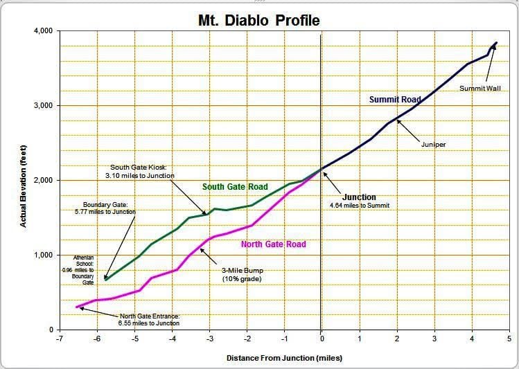
Another fantastic graphic from DiabloScott.
Note that South Gate on Diablo has an ever-so-brief slight descent in the Rock City. It is really short, but it is there and it might disqualify South Gate from your consideration. North Gate has no such descent, and neither does Summit Road.
I'd suggest Mt Hamilton (~20 miles from bottom to top) but it has two descents that seem short on the way up to the observatory but seem unpleasantly long as ascents on your way back.
If you like hair shirts, mortification of the flesh and that sort of thing, you might try the east side of Patterson Pass Road (going from Tracy to Livermore). I don't think it is 10 miles long, but it does not have descents. at least not until you reach the top. What it does have is a 13% or so pitch to the Mother of All False Summits (this is not an exaggeration) from which you get a soul-crushing view of the actual summit and the ~20% stairsteps to it. For real fun, do it in the late afternoon in August, when it is 100* out (there's no shade) and the afternoon wind is howling over the pass and into your face.
__________________
"I'm in shape -- round is a shape." Andy Rooney
"I'm in shape -- round is a shape." Andy Rooney
Likes For bikingshearer:
04-17-23, 06:32 PM
#10
Happy banana slug

Join Date: Sep 2015
Location: Arcata, California, U.S., North America, Earth, Saggitarius Arm, Milky Way
Posts: 3,696
Bikes: 1984 Araya MB 261, 1992 Specialized Rockhopper Sport, 1993 Hard Rock Ultra, 1994 Trek Multitrack 750, 1995 Trek Singletrack 930
Mentioned: 31 Post(s)
Tagged: 0 Thread(s)
Quoted: 1533 Post(s)
Liked 1,530 Times
in
917 Posts
If you like hair shirts, mortification of the flesh and that sort of thing, you might try the east side of Patterson Pass Road (going from Tracy to Livermore). I don't think it is 10 miles long, but it does not have descents. at least not until you reach the top. What it does have is a 13% or so pitch to the Mother of All False Summits (this is not an exaggeration) from which you get a soul-crushing view of the actual summit and the ~20% stairsteps to it. For real fun, do it in the late afternoon in August, when it is 100* out (there's no shade) and the afternoon wind is howling over the pass and into your face.
 Thanks for the nostalgia; I grew up in Tracy, directly east of Corral Hollow Rd. I remember the wind; the only time it wasn't windy it was 110F.
Likes For Korina:
04-18-23, 05:44 PM
#11
Full Member
Join Date: Aug 2010
Posts: 331
Mentioned: 0 Post(s)
Tagged: 0 Thread(s)
Quoted: 29 Post(s)
Likes: 0
Liked 11 Times
in
9 Posts
Another fantastic graphic from DiabloScott.
Note that South Gate on Diablo has an ever-so-brief slight descent in the Rock City. It is really short, but it is there and it might disqualify South Gate from your consideration. North Gate has no such descent, and neither does Summit Road.
I'd suggest Mt Hamilton (~20 miles from bottom to top) but it has two descents that seem short on the way up to the observatory but seem unpleasantly long as ascents on your way back.
If you like hair shirts, mortification of the flesh and that sort of thing, you might try the east side of Patterson Pass Road (going from Tracy to Livermore). I don't think it is 10 miles long, but it does not have descents. at least not until you reach the top. What it does have is a 13% or so pitch to the Mother of All False Summits (this is not an exaggeration) from which you get a soul-crushing view of the actual summit and the ~20% stairsteps to it. For real fun, do it in the late afternoon in August, when it is 100* out (there's no shade) and the afternoon wind is howling over the pass and into your face.
Note that South Gate on Diablo has an ever-so-brief slight descent in the Rock City. It is really short, but it is there and it might disqualify South Gate from your consideration. North Gate has no such descent, and neither does Summit Road.
I'd suggest Mt Hamilton (~20 miles from bottom to top) but it has two descents that seem short on the way up to the observatory but seem unpleasantly long as ascents on your way back.
If you like hair shirts, mortification of the flesh and that sort of thing, you might try the east side of Patterson Pass Road (going from Tracy to Livermore). I don't think it is 10 miles long, but it does not have descents. at least not until you reach the top. What it does have is a 13% or so pitch to the Mother of All False Summits (this is not an exaggeration) from which you get a soul-crushing view of the actual summit and the ~20% stairsteps to it. For real fun, do it in the late afternoon in August, when it is 100* out (there's no shade) and the afternoon wind is howling over the pass and into your face.
I have made the mistake of doing it on a 100 degree day, and also done it while the wind was howling over the pass and into my face so strong that gusts brought my already slow speed to a virtual stop, but I haven't experienced both at the same time. If there is much breeze on a 100 degree day, in my experience it is more often than not coming out of the east, so giving a slight boost up the hill. Not that it is very much help. When I'm stupid enough to be there on a 100 degree day, I at least am smart enough to have enough water to occasionally douse myself a little. I have told people complaining about the howling wind in 80 degree weather to be happy about the wind, because otherwise it would be 100 degrees.
I went down the east side a handful of times before I ever went up it. My first time up the east side I was on a group ride doing a counterclockwise loop going Livermore to Tracy via Corral Hollow and back via Patterson Pass. I made the mistake of trying this when I was just getting back in shape after being off the bike with a broken hand. As I was struggling to get to the Mother of All False Summits, the group leader "encouraged" me by pointing out it was only 1/4 mile to the summit. The leader questioned my assertion that it was a false summit. I assured him I had been down that way enough to know I was correct, he still wasn't quite believing me, and he sheepishly apologized when we got there and looked ahead to what we had left. I felt a little better when another rider in our group up ahead was walking the last pitch, so when I caught up, I did the same, but I have not walked it since.
My dim recollection is that sometime in the past, DiabloScott has shown us the profiles of east side of Patterson Pass compared to Diablo from the junction to the summit, and Diablo is a little worse, but I could be wrong. Diablo junction to summit generally feels worse to me, mostly because I've already gone up either North Gate or South Gate, but when the wind is really howling from the west over Patterson, that last pitch feels worse than the wall at Diablo.
04-19-23, 01:32 PM
#12
Crawlin' up, flyin' down
Join Date: Jan 2006
Location: Democratic Peoples' Republic of Berkeley
Posts: 5,658
Bikes: 1967 Paramount; 1982-ish Ron Cooper; 1978 Eisentraut "A"; two mid-1960s Cinelli Speciale Corsas; and others in various stages of non-rideability.
Mentioned: 40 Post(s)
Tagged: 0 Thread(s)
Quoted: 1027 Post(s)
Liked 2,531 Times
in
1,059 Posts
The east side of Patterson Pass is indeed much less than 10 miles, more like 5 miles from the substation.
I have made the mistake of doing it on a 100 degree day, and also done it while the wind was howling over the pass and into my face so strong that gusts brought my already slow speed to a virtual stop, but I haven't experienced both at the same time. If there is much breeze on a 100 degree day, in my experience it is more often than not coming out of the east, so giving a slight boost up the hill. Not that it is very much help. When I'm stupid enough to be there on a 100 degree day, I at least am smart enough to have enough water to occasionally douse myself a little. I have told people complaining about the howling wind in 80 degree weather to be happy about the wind, because otherwise it would be 100 degrees.
I went down the east side a handful of times before I ever went up it. My first time up the east side I was on a group ride doing a counterclockwise loop going Livermore to Tracy via Corral Hollow and back via Patterson Pass. I made the mistake of trying this when I was just getting back in shape after being off the bike with a broken hand. As I was struggling to get to the Mother of All False Summits, the group leader "encouraged" me by pointing out it was only 1/4 mile to the summit. The leader questioned my assertion that it was a false summit. I assured him I had been down that way enough to know I was correct, he still wasn't quite believing me, and he sheepishly apologized when we got there and looked ahead to what we had left. I felt a little better when another rider in our group up ahead was walking the last pitch, so when I caught up, I did the same, but I have not walked it since.
My dim recollection is that sometime in the past, DiabloScott has shown us the profiles of east side of Patterson Pass compared to Diablo from the junction to the summit, and Diablo is a little worse, but I could be wrong. Diablo junction to summit generally feels worse to me, mostly because I've already gone up either North Gate or South Gate, but when the wind is really howling from the west over Patterson, that last pitch feels worse than the wall at Diablo.
I'm so glad I live in Berkeley now. I've become a weather wimp, without regret or apology.
BTW, referring to climbing the east side of Patterson Pass, you could have just said "I made the mistake of doing it" and stopped there. It almost doesn't matter what the weather is - it's a tough climb and the Mother of All False Summits is a soul-crusher even if you know it is coming. More so if you don't know it's coming, but still . . . .
__________________
"I'm in shape -- round is a shape." Andy Rooney
"I'm in shape -- round is a shape." Andy Rooney
04-26-23, 09:17 PM
#13
Full Member
Aahh, nostalgia. I rode it once long ago, with a buddy who had read about the ride and planned our route. We had the full blast wind but only moderate 80deg heat.
I think my "I can make it, I'm going to make it!" had started to be out loud instead of just internal, when my friend says "I wonder if this is the false summit?"
I think my "I can make it, I'm going to make it!" had started to be out loud instead of just internal, when my friend says "I wonder if this is the false summit?"
05-31-23, 07:13 AM
#15
Senior Member
Thread Starter
Join Date: Mar 2020
Location: Nevada County, California
Posts: 790
Bikes: Subject to change at any given moment but currently is...... Colnago Mapei, Colnago C40, Wilier Triestina Carbon, Wilier Triestina Ramato, Follis 472, Peugeot PX60, Razesa, Orbea Terra, Soma Pescadero and 1/2 owner of a Santana tandem.
Mentioned: 2 Post(s)
Tagged: 0 Thread(s)
Quoted: 336 Post(s)
Liked 782 Times
in
264 Posts
[QUOTE=sean.hwy;22907798]have a strava route for this?[/https://strava.app.link/WMWNE20yfAb
There you go !
There you go !
Likes For Tomm Willians:
05-31-23, 11:55 AM
#16
Senior Member

Join Date: Jan 2020
Location: San Jose
Posts: 1,025
Bikes: Blur / Ibis Hakka MX / team machince alr2 / topstone 1
Mentioned: 1 Post(s)
Tagged: 0 Thread(s)
Quoted: 426 Post(s)
Liked 274 Times
in
201 Posts
[QUOTE=Tomm Willians;22907913]
thank you
https://www.strava.com/segments/6893019
that looks painful
https://www.strava.com/segments/6893019
Full Toomes Climb
- Distance11.96mi
- Elevation Gain3,927ft
- Avg Grade5.9%
- Lowest Elev1,031ft
- Highest Elev4,781ft
- Elev Difference3,750ft
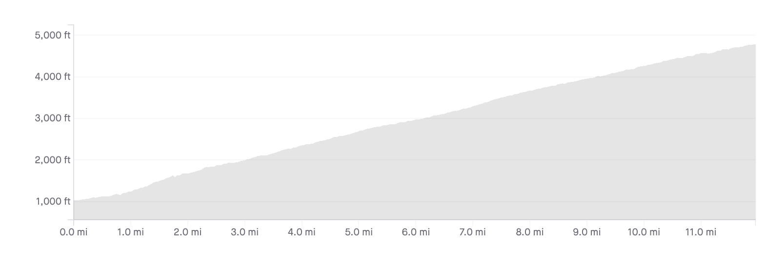
that looks painful
06-02-23, 03:23 PM
#17
Disco Infiltrator

Join Date: May 2013
Location: Folsom CA
Posts: 13,446
Bikes: Stormchaser, Paramount, Tilt, Samba tandem
Mentioned: 72 Post(s)
Tagged: 0 Thread(s)
Quoted: 3126 Post(s)
Liked 2,105 Times
in
1,369 Posts
There are probably plenty of railroad grades that climb like that in the coast range and the Sierras. Maybe not all of them bicycle friendly. Kingsbury Grade from State Line to Carson City is the one that comes first to mind
__________________
Genesis 49:16-17
Genesis 49:16-17
06-02-23, 03:32 PM
#18
Disco Infiltrator
Join Date: May 2013
Location: Folsom CA
Posts: 13,446
Bikes: Stormchaser, Paramount, Tilt, Samba tandem
Mentioned: 72 Post(s)
Tagged: 0 Thread(s)
Quoted: 3126 Post(s)
Liked 2,105 Times
in
1,369 Posts
ok, from the Foothill park and ride to the top of Tramway is 9.3 miles and 2900+ feet. Also, high altitude! Probably terrifying, it's a big road
__________________
Genesis 49:16-17
Genesis 49:16-17
