


Lezyne Mega XL - anyone using it?
 07-30-19, 01:11 PM
#26

Jedi Master

@Lezyne, for brevets that are longer than one day, the ride organizer usually posts a separate route to RWGPS for every day of the ride, so on a 1,00k it's common to have a ~400k route for the first day ~300k for the second day and ~300k for the third day. Sounds to me like you are confirming that it's not possible to load all three of those routes into the device and start the ride each morning without a phone or a computer, right?
 07-30-19, 04:46 PM
#27
Senior Member
Join Date: Feb 2017
Location: Chicago, IL
Posts: 518
Bikes: 2004 Trek 520, resto-modded 1987 Cannondale SR400, rando-modded 1976 AD Vent Noir; 2019 Wabi Classic; 1989? Burley Duet
Mentioned: 7 Post(s)
Tagged: 0 Thread(s)
Quoted: 213 Post(s)
Liked 93 Times
in
51 Posts
@Lezyne I�d love to know this too. Anything that could get around the transfer-route-from-phone-to-GPS problems would be a game changer.
I was unaware that I could even start navigating from the GPS. I could be mistaken but I don�t think that was in the instructions.
I was unaware that I could even start navigating from the GPS. I could be mistaken but I don�t think that was in the instructions.
07-31-19, 12:42 PM
#28
Official

Join Date: Jan 2018
Posts: 12
Mentioned: 2 Post(s)
Tagged: 0 Thread(s)
Quoted: 5 Post(s)
Likes: 0
Liked 0 Times
in
0 Posts
@Lezyne, for brevets that are longer than one day, the ride organizer usually posts a separate route to RWGPS for every day of the ride, so on a 1,00k it's common to have a ~400k route for the first day ~300k for the second day and ~300k for the third day. Sounds to me like you are confirming that it's not possible to load all three of those routes into the device and start the ride each morning without a phone or a computer, right?
That said, as long as the routes are refreshed on your phone, you only need to select the route and press go (This can happen with or without a data connection). Once navigation has started, you can turn off your phone and store it, the GPS will continue navigation.
@Lezyne I�d love to know this too. Anything that could get around the transfer-route-from-phone-to-GPS problems would be a game changer.
I was unaware that I could even start navigating from the GPS. I could be mistaken but I don�t think that was in the instructions.
I was unaware that I could even start navigating from the GPS. I could be mistaken but I don�t think that was in the instructions.
As for the instructions, we're actually constantly working on new features and updates, so depending on when you got your device (or when the retailer received the device) it might not have been in there. For any other use questions, I usually refer people to the support site. We've spent a LONG time overhauling our customer service platform and are constantly adding new support articles, FAQ's etc. Obviously you won't get much in the way of user experience/reviews, but GPS devices are extremely complicated and there is A LOT of information there. Also, it's worth noting that our team really does enjoy answering questions beyond the generic response of "Our team will be happy to help." They're all cyclists too and it's always a win when they're able to clear up confusion or find a solution.
07-31-19, 02:22 PM
#29
Senior Member
Join Date: Feb 2017
Location: Chicago, IL
Posts: 518
Bikes: 2004 Trek 520, resto-modded 1987 Cannondale SR400, rando-modded 1976 AD Vent Noir; 2019 Wabi Classic; 1989? Burley Duet
Mentioned: 7 Post(s)
Tagged: 0 Thread(s)
Quoted: 213 Post(s)
Liked 93 Times
in
51 Posts
That's correct. You can only start the last "Saved Route" without any phone connection.
That said, as long as the routes are refreshed on your phone, you only need to select the route and press go (This can happen with or without a data connection). Once navigation has started, you can turn off your phone and store it, the GPS will continue navigation.
If you're still having issues, I would highly recommend contacting our customer service department. There are just so many variables when it comes to troubleshooting GPS devices/Phones that the best thing to do is to talk with somebody directly. Most of the issues we see are solved with firmware updates, but it's impossible to say exactly what's going on without knowing the full story.
As for the instructions, we're actually constantly working on new features and updates, so depending on when you got your device (or when the retailer received the device) it might not have been in there. For any other use questions, I usually refer people to the support site. We've spent a LONG time overhauling our customer service platform and are constantly adding new support articles, FAQ's etc. Obviously you won't get much in the way of user experience/reviews, but GPS devices are extremely complicated and there is A LOT of information there. Also, it's worth noting that our team really does enjoy answering questions beyond the generic response of "Our team will be happy to help." They're all cyclists too and it's always a win when they're able to clear up confusion or find a solution.
08-15-19, 10:56 AM
#30
Senior Member
I currently have a mini and a super. They have learning curves but most people just want to put it on and go without learning the whole process. I was guilty of that myself. Spent some time learning the process and now.....I have a mega to be delivered tomorrow. It's a solid product, we just have to make sure we do our part to make it work, if we don't understand the process it's honestly not fair to blame the product. I have the speed and cadence sensor as well as the heat rate monitor. All connect and work flawlessly.
I REALLY need to thin my herd by at least one...lol.
I REALLY need to thin my herd by at least one...lol.
Last edited by mynewnchome; 08-15-19 at 11:02 AM.
08-15-19, 11:47 PM
#31
Senior Member
Good video about set up, no narration though and they go through some things fast.
08-24-19, 01:39 AM
#32
Senior Member

Join Date: Dec 2007
Posts: 740
Mentioned: 4 Post(s)
Tagged: 0 Thread(s)
Quoted: 359 Post(s)
Liked 85 Times
in
58 Posts
Problems with all Lezyne computers is that their mounts are flimsy and that the tabs on the back of the computer snap off.
The lack of options to mount a light under the mount has also previously annoyed me (not sure if they have fixed this yet, but for a company that makes great lights and a great computer to not have this option is just silly).
I went back to Garmin after having 2 Lezyne's snap off the tabs (yep, I know that Garmin snaps tabs too).
08-25-19, 12:47 PM
#33
Sunshine

Join Date: Aug 2014
Location: Des Moines, IA
Posts: 16,614
Bikes: '18 class built steel roadbike, '19 Fairlight Secan, '88 Schwinn Premis , Black Mountain Cycles Monstercross V4, '89 Novara Trionfo
Mentioned: 123 Post(s)
Tagged: 0 Thread(s)
Quoted: 10964 Post(s)
Liked 7,491 Times
in
4,189 Posts
Problems with all Lezyne computers is that their mounts are flimsy and that the tabs on the back of the computer snap off.
The lack of options to mount a light under the mount has also previously annoyed me (not sure if they have fixed this yet, but for a company that makes great lights and a great computer to not have this option is just silly).
I went back to Garmin after having 2 Lezyne's snap off the tabs (yep, I know that Garmin snaps tabs too).
The lack of options to mount a light under the mount has also previously annoyed me (not sure if they have fixed this yet, but for a company that makes great lights and a great computer to not have this option is just silly).
I went back to Garmin after having 2 Lezyne's snap off the tabs (yep, I know that Garmin snaps tabs too).
As for the tabs...haven't noticed that. The tabs seem quite robust. And if it happens on Garmin too, it's really not an issue specific to one brand.
06-04-20, 12:59 AM
#34
Senior Member
Thread Starter
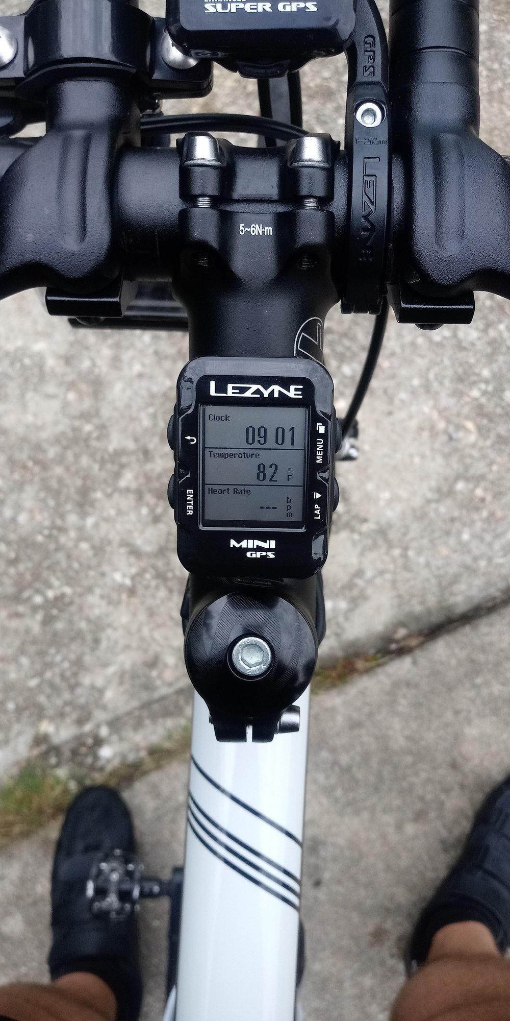
I've had a Mega XL for a couple months now, and I like it just fine. As others have said, you can use it without needing a cell phone at all, something that was confusing to me before I got it.
The grade function seems to be a lot more accurate and immediate than it was on my old Garmin 800, which had a lag time of several seconds, making it essentially useless for ascertaining the actual grade you're climbing or descending moment by moment. So that's cool.
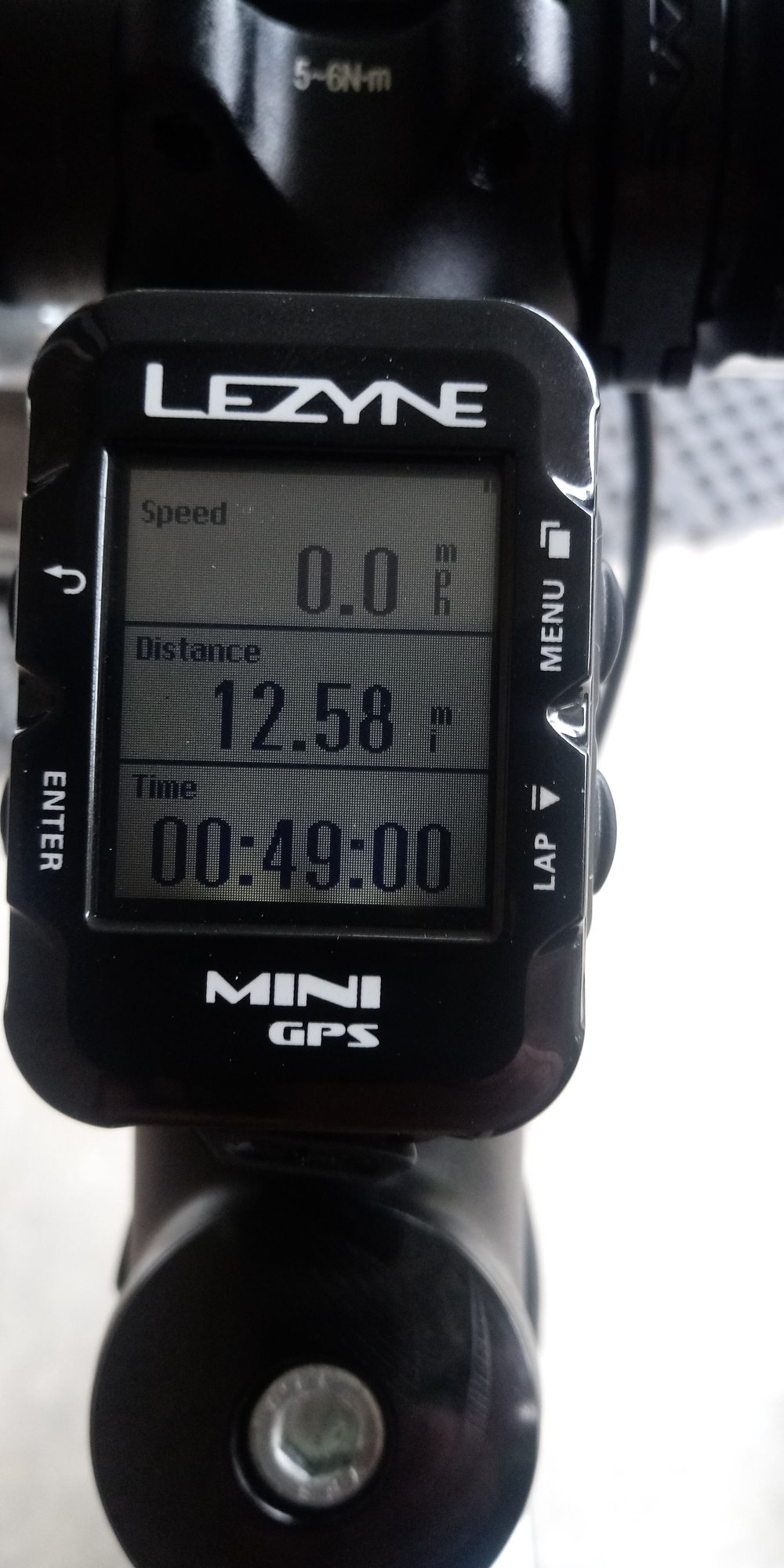
I only have one issue: I'd really like the option of a data page with two full width fields at the top, and then three rows of two fields side by side underneath. Basically, the opposite of what is shown in the photo, i.e. I'd like the KM (distance) and KMH (speed) fields on the top instead of on the bottom. Would anyone happen to know if there's a way to modify the data pages? As far as I can tell you have to choose among the nine or so page options they give you, and my preferred configuration isn't offered.

*I mistakenly called it the "Lezyne Mega XI" in the title when I first posted this thread. Would a mod be able to change it to "Lezyne Mega XL"?
The grade function seems to be a lot more accurate and immediate than it was on my old Garmin 800, which had a lag time of several seconds, making it essentially useless for ascertaining the actual grade you're climbing or descending moment by moment. So that's cool.
I only have one issue: I'd really like the option of a data page with two full width fields at the top, and then three rows of two fields side by side underneath. Basically, the opposite of what is shown in the photo, i.e. I'd like the KM (distance) and KMH (speed) fields on the top instead of on the bottom. Would anyone happen to know if there's a way to modify the data pages? As far as I can tell you have to choose among the nine or so page options they give you, and my preferred configuration isn't offered.
*I mistakenly called it the "Lezyne Mega XI" in the title when I first posted this thread. Would a mod be able to change it to "Lezyne Mega XL"?
Last edited by rousseau; 06-06-20 at 02:50 AM.
06-05-20, 05:52 PM
#36
Junior Member
Rousseau
Configuring pages is available from Page 21 onwards in the Lezyne manual. What you are specifically looking for is on Page 23. You have to use the mobile app and configure your GPS settings. In the page, you can select the layout, and then click on each cell of your preferred layout to select the metric you would like to be displayed. Once you get the hang of it, it's pretty easy and also will take up a lot of your time (too many possibillities :-))
https://www.lezyne.com/downloads/Meg...R1-English.pdf
06-05-20, 05:54 PM
#37
Junior Member
Sorry. Reread your post. I don't think it's possible to change the page layouts beyond what's offered by Lezyne. What I found is that they are very receptive to feedback, so maybe an email to them could help.
02-17-21, 03:23 PM
#38
Senior Member
Thread Starter
I only have one issue: I'd really like the option of a data page with two full width fields at the top, and then three rows of two fields side by side underneath. Basically, the opposite of what is shown in the photo, i.e. I'd like the KM (distance) and KMH (speed) fields on the top instead of on the bottom. Would anyone happen to know if there's a way to modify the data pages? As far as I can tell you have to choose among the nine or so page options they give you, and my preferred configuration isn't offered.
Sheesh.
Another thing I don't like is the lack of a compass. I like knowing what direction I'm travelling in. And another thing I don't like is how non-intuitive and confusing the GPS mapping is compared to Garmin. I never actually figured it out.
I'm going to try version 1 of the Hammerhead Karoo now, the people upgrading to version 2 are selling them. Gets good reviews. The Mega XL is going on Kijiji.

