


Routing?
 10-31-19, 02:56 PM
#26
Senior Member
Join Date: Sep 2007
Location: Far beyond the pale horizon.
Posts: 14,259
Mentioned: 31 Post(s)
Tagged: 0 Thread(s)
Quoted: 4245 Post(s)
Liked 1,349 Times
in
936 Posts
The editor I first learned to use (Potlatch 2) is sort-of going away (it's written in Flash). So, I have to learn another editor (ID).
Just start out making small changes. And make changes that represent "truth" rather than trying to fudge things to "get something to work". All sorts of people and things rely on your changes.
"Ways" can be "tracks" (very primitive roads that are "drivable") or "generic paths" (hikeable, MTB-able).
PM me with the location.
Last edited by njkayaker; 10-31-19 at 03:01 PM.

Likes For njkayaker:
10-31-19, 02:57 PM
#27

don't try this at home.

Join Date: Jan 2006
Location: N. KY
Posts: 5,933
Mentioned: 10 Post(s)
Tagged: 0 Thread(s)
Quoted: 972 Post(s)
Liked 509 Times
in
349 Posts
As others have mentioned, ridewithgps.com is the best method for creating routes. A free login is all you need.
On the ridewithgps web page:
Click Route Planner.
Just browse or pan the map to your starting location. Click the starting point, then click on a road that you want to take. It will follow roads to this waypoint. Keep clicking ahead to build the route. You can Undo/Redo or drag the route line to a new road. It shows distance and elevation as you make the route. Drag part of the red elevation chart to see the grades on that hill.
Give it a name and save it.
Now you can view the completed route map and Export your route file. Most newer Garmins like yours use the .fit format.
Copy the route file to your Garmin
I've never used the app to import routes. I should try it sometime.
I still use the simple, old-school import method:
1. plug in the Garmin via usb
2. in the Windows file browser, copy the .fit file from the folder it was downloaded into.
3. in the Garmin drive, showing as D: or another drive letter, navigate to Garmin --> NewFiles
4. paste the .fit file into NewFiles folder.
It gets converted into a Course when the Garmin is next rebooted, and disappears from the NewFiles folder. (Don't put the new .fit file directly into the Courses folder, use the NewFiles folder.)
Now boot the Garmin.
Navigate --> Courses --> Saved courses
There it is!
Last edited by rm -rf; 10-31-19 at 03:01 PM.
Likes For rm -rf:
10-31-19, 03:03 PM
#28
Senior Member
Join Date: Sep 2007
Location: Far beyond the pale horizon.
Posts: 14,259
Mentioned: 31 Post(s)
Tagged: 0 Thread(s)
Quoted: 4245 Post(s)
Liked 1,349 Times
in
936 Posts
Still, Ridewithgps is a very good route planner and it makes it easy to make the routes accessible to people.
10-31-19, 04:32 PM
#29
Senior Member
Thread Starter
Join Date: Apr 2013
Posts: 1,173
Bikes: Surly Disk Trucker, 2014 w/Brooks Flyer Special saddle, Tubus racks - Duo front/Logo Evo rear, 2019 Dahon Mariner D8, Both bikes share Ortlieb Packer Plus series panniers, Garmin Edge 1000
Mentioned: 2 Post(s)
Tagged: 0 Thread(s)
Quoted: 405 Post(s)
Liked 115 Times
in
99 Posts
However, the turn-by-turn nav is not available unless you pay for a subscription to Ride With GPS.
The other tidbit I found was that the route creation in Ride With GPS is exact how it translates to the Edge1000 - as in the waypoints create the exact path - segmented straight lines. It does not re-draw the waypoints to fall along the existing road or trail in which they are placed. So the screen is showing the segmented path - which may not follow the curves of a road or trail that I had intended to follow.
More learning to come... making some headway, though.
I did have a .fit file editor at one point. I was using it to try to export the ride data to a spreadsheet, if I recall correctly. I've just been manually entering the data this season though. I'd be curious if there is a way to create a gpx file then convert to .fit with turn-by-turn directions. We'll see.
10-31-19, 04:55 PM
#30
Senior Member
Thread Starter
Join Date: Apr 2013
Posts: 1,173
Bikes: Surly Disk Trucker, 2014 w/Brooks Flyer Special saddle, Tubus racks - Duo front/Logo Evo rear, 2019 Dahon Mariner D8, Both bikes share Ortlieb Packer Plus series panniers, Garmin Edge 1000
Mentioned: 2 Post(s)
Tagged: 0 Thread(s)
Quoted: 405 Post(s)
Liked 115 Times
in
99 Posts
The other tidbit I found was that the route creation in Ride With GPS is exact how it translates to the Edge1000 - as in the waypoints create the exact path - segmented straight lines. It does not re-draw the waypoints to fall along the existing road or trail in which they are placed. So the screen is showing the segmented path - which may not follow the curves of a road or trail that I had intended to follow.
I found Komoot. It lets me upload a file. There is an option in there to use the existing file as-is, or to edit the file so the track meets the existing roads/trails. I chose the option to match the existing roads/trails. This almost did a perfect job, other than about 15 waypoints that I had to pull back to the route.
However, Komoot wants a subscription to even export the file at all. So I'm back to the base segmented, non-TBT file I got from Ride With GPS.
More learning to come..
10-31-19, 05:32 PM
#31
Junior Member
Join Date: Aug 2019
Posts: 22
Mentioned: 0 Post(s)
Tagged: 0 Thread(s)
Quoted: 4 Post(s)
Likes: 0
Liked 4 Times
in
3 Posts
I also hesitated about paying the subscription for RideWithGPS, but decided to try it (7 day? free trial). Learned it enough to know it would work for me much better than Strava and RWGPS knows dirt / gravel trails in forests around here. Good luck with your learning curve. Also agree with njkayaker that almost any GPS routing program will work, it mostly is what floats your boat! Which do you think is easiest to use and satisfies your requirements.
10-31-19, 06:05 PM
#32
Senior Member
Join Date: Jul 2007
Location: South shore, L.I., NY
Posts: 6,859
Bikes: Flyxii FR322, Cannondale Topstone, Miyata City Liner, Specialized Chisel, Specialized Epic Evo
Mentioned: 18 Post(s)
Tagged: 0 Thread(s)
Quoted: 3221 Post(s)
Liked 2,049 Times
in
1,171 Posts
Update to my last post -
I found Komoot. It lets me upload a file. There is an option in there to use the existing file as-is, or to edit the file so the track meets the existing roads/trails. I chose the option to match the existing roads/trails. This almost did a perfect job, other than about 15 waypoints that I had to pull back to the route.
However, Komoot wants a subscription to even export the file at all. So I'm back to the base segmented, non-TBT file I got from Ride With GPS.
More learning to come..
As note about the iQ app. You visit the iQ store using the Garmin Connect Mobile app, select an app, download to the device for install. You then access the iQ apps on the device, it launches the app and (as with RWGPS) you connect to the route planning server to access the routes you've developed (or some of them - most recent as example). You then select Download and Ride. It works great with RWGPS in my experience and other than the Garmin Connect developed courses, is the easiest method to get a web created course to the device.
 10-31-19, 06:05 PM
#33
Senior Member
Thread Starter
Join Date: Apr 2013
Posts: 1,173
Bikes: Surly Disk Trucker, 2014 w/Brooks Flyer Special saddle, Tubus racks - Duo front/Logo Evo rear, 2019 Dahon Mariner D8, Both bikes share Ortlieb Packer Plus series panniers, Garmin Edge 1000
Mentioned: 2 Post(s)
Tagged: 0 Thread(s)
Quoted: 405 Post(s)
Liked 115 Times
in
99 Posts
Well I got this mess licked.
How I was able to do it was convert google maps directions to gpx. Apparently the Edge 1000 will take a .GPX file along with a .FIT file. Or it somehow just converts .GPX to .FIT.
In any event, I tuned the route in google and so far it looks correct on the Edge 1000. I pulled in over 94 miles of a route and at least on first look it is correct. Of course, I have not rode the route to verify yet.
This is a "complicated" process, but it is do-able. The file on the Garmin, also, does not come out labeled as the .GPX file name. I found the file on the Edge 1000 by looking at the distance instead.
10-31-19, 06:07 PM
#34
Senior Member
Join Date: Jul 2007
Location: South shore, L.I., NY
Posts: 6,859
Bikes: Flyxii FR322, Cannondale Topstone, Miyata City Liner, Specialized Chisel, Specialized Epic Evo
Mentioned: 18 Post(s)
Tagged: 0 Thread(s)
Quoted: 3221 Post(s)
Liked 2,049 Times
in
1,171 Posts
I also hesitated about paying the subscription for RideWithGPS, but decided to try it (7 day? free trial). Learned it enough to know it would work for me much better than Strava and RWGPS knows dirt / gravel trails in forests around here. Good luck with your learning curve. Also agree with njkayaker that almost any GPS routing program will work, it mostly is what floats your boat! Which do you think is easiest to use and satisfies your requirements.
https://www.trailforks.com/
10-31-19, 06:08 PM
#35
Senior Member
Thread Starter
Join Date: Apr 2013
Posts: 1,173
Bikes: Surly Disk Trucker, 2014 w/Brooks Flyer Special saddle, Tubus racks - Duo front/Logo Evo rear, 2019 Dahon Mariner D8, Both bikes share Ortlieb Packer Plus series panniers, Garmin Edge 1000
Mentioned: 2 Post(s)
Tagged: 0 Thread(s)
Quoted: 405 Post(s)
Liked 115 Times
in
99 Posts
I believe that Kamoot is popular with folks doing long tours, thus might be worth the subscription. It's also a free Garmin iQ app you can install on the Edge 1000. If that works like the RWGPS iQ app it lets you access the routes developed on Kamoot and download routes directly to the device via a smartphone and BlueTooth. That feature in with the RWGPS iQ app is really useful.
As note about the iQ app. You visit the iQ store using the Garmin Connect Mobile app, select an app, download to the device for install. You then access the iQ apps on the device, it launches the app and (as with RWGPS) you connect to the route planning server to access the routes you've developed (or some of them - most recent as example). You then select Download and Ride. It works great with RWGPS in my experience and other than the Garmin Connect developed courses, is the easiest method to get a web created course to the device.
As note about the iQ app. You visit the iQ store using the Garmin Connect Mobile app, select an app, download to the device for install. You then access the iQ apps on the device, it launches the app and (as with RWGPS) you connect to the route planning server to access the routes you've developed (or some of them - most recent as example). You then select Download and Ride. It works great with RWGPS in my experience and other than the Garmin Connect developed courses, is the easiest method to get a web created course to the device.
If the file itself doesn't have TBT and is segmented then iQ, as interesting and fancy as it may be, does me absolutely no good. I can simply move the file to the right folder and skip iQ entirely.
10-31-19, 07:21 PM
#36
Senior Member
Join Date: Jul 2007
Location: South shore, L.I., NY
Posts: 6,859
Bikes: Flyxii FR322, Cannondale Topstone, Miyata City Liner, Specialized Chisel, Specialized Epic Evo
Mentioned: 18 Post(s)
Tagged: 0 Thread(s)
Quoted: 3221 Post(s)
Liked 2,049 Times
in
1,171 Posts
If you choose to use a “High tech/user unfriendly/engineer only/programming” mode of transferring via a USB cable and file transfer, that’s up to you. I only cable connect my 1030 to update the OS. All course loading is via BT. My choice as well, but as I am willing to pay RWGPS to use their very fine service to be my activity tracker, I am able to take advantage of the easier route transfer method.
But I’m glad you got stuff figured out, it’s always rewarding when you can get technology to do what you want. Garmin stuff sometimes doesn’t lend itself to getting figured out, so kudos for doing it.
But I’m glad you got stuff figured out, it’s always rewarding when you can get technology to do what you want. Garmin stuff sometimes doesn’t lend itself to getting figured out, so kudos for doing it.
11-01-19, 08:28 AM
#38
Senior Member
Join Date: Sep 2007
Location: Far beyond the pale horizon.
Posts: 14,259
Mentioned: 31 Post(s)
Tagged: 0 Thread(s)
Quoted: 4245 Post(s)
Liked 1,349 Times
in
936 Posts
You have to enable "Turn Guidance" on your device. In the course list, click the settings (three horizontal bars). Turn on "Turn Guidance".
There are two types of TBT:
1- "Turn guidance" - this is calculated by the device using the track data in the file you downloaded to the device. These show up a s big white arrows.
2- "Course points" - these are "waypoints" embedded in TCX and FIT files. These pop-up on the device when you get to the point. These are intended more for devices that don't use maps.
You can get both with RWGPS (without a subscription).
The other tidbit I found was that the route creation in Ride With GPS is exact how it translates to the Edge1000 - as in the waypoints create the exact path - segmented straight lines. It does not re-draw the waypoints to fall along the existing road or trail in which they are placed. So the screen is showing the segmented path - which may not follow the curves of a road or trail that I had intended to follow.
You need to click the "Follow Roads" option ("roads" means any path/road).
Also, change the map (upper right) to use OSM (Openstreetmap).
The files contain a "track", which is a list of points that describes the path you want to take. It has enough points to accurately trace the curves and turns of your intended path.
The TBT is created by the Garmin. It's not in the file.**
The route planners (all of them) let you use roads/paths by making the "pen" stick to (follow) the roads/paths.
-----------------------------------------------
** Other than "course points", which are a separate thing.
Last edited by njkayaker; 11-01-19 at 08:43 AM.
11-01-19, 08:46 AM
#39
Senior Member
Join Date: Sep 2007
Location: Far beyond the pale horizon.
Posts: 14,259
Mentioned: 31 Post(s)
Tagged: 0 Thread(s)
Quoted: 4245 Post(s)
Liked 1,349 Times
in
936 Posts
This information can be stored in many formats.
The Garmins can GPX. FIT, and TCX (different formats containing the same information).
I downloaded iQ. All that does is give me a "high tech/user friendly/non-engineering/non-programmer" method for "transferring" a track/route file.
If the file itself doesn't have TBT and is segmented then iQ, as interesting and fancy as it may be, does me absolutely no good. I can simply move the file to the right folder and skip iQ entirely.
If the file itself doesn't have TBT and is segmented then iQ, as interesting and fancy as it may be, does me absolutely no good. I can simply move the file to the right folder and skip iQ entirely.
If it's "segmented", you aren't doing something correctly.
=============================
You should figure out how to use RWGPS first.
People recommend it because it works (for tens of thousands of people).
Other planners work similarly. So, if you figure RWGPS out, you'll be able to figure out other things.
Using other things now will likely just confuse you. There are lots of options.
Last edited by njkayaker; 11-01-19 at 09:02 AM.
11-01-19, 09:30 AM
#40
Senior Member
Thread Starter
Join Date: Apr 2013
Posts: 1,173
Bikes: Surly Disk Trucker, 2014 w/Brooks Flyer Special saddle, Tubus racks - Duo front/Logo Evo rear, 2019 Dahon Mariner D8, Both bikes share Ortlieb Packer Plus series panniers, Garmin Edge 1000
Mentioned: 2 Post(s)
Tagged: 0 Thread(s)
Quoted: 405 Post(s)
Liked 115 Times
in
99 Posts
You should figure out how to use RWGPS first.
People recommend it because it works (for tens of thousands of people).
Other planners work similarly. So, if you figure RWGPS out, you'll be able to figure out other things.
Using other things now will likely just confuse you. There are lots of options.
With all due respect, though - what I experienced with lack of TBT and segmented tracks doesn't make sense to me. What does make sense to me is the google file, converting it to GPX, and dropping it in the appropriate folder in my unit. That isn't to say that method makes sense to you, nor anyone else.
However, what I can say from the converstion experience is the fil,e as it was converted from google maps to .gpx format, has the TBT and routing that I am looking for contained within the file already because I have to do nothing on the Edge 1000 to get it to work - simply pick a file and hit the "ride" button to activate it. TBT is already there.
So, and again - respectfully, this method makes sense to me whereas the troubles I had earlier in my "quest" in this thread did not - hence the thread until I could get to a place I wanted to be. I am where I want to be with the method I have now. That doesn't mean there aren't ways to make the others work, they may be a method for a later time to try.
11-01-19, 09:49 AM
#41
Senior Member
Join Date: Sep 2007
Location: Far beyond the pale horizon.
Posts: 14,259
Mentioned: 31 Post(s)
Tagged: 0 Thread(s)
Quoted: 4245 Post(s)
Liked 1,349 Times
in
936 Posts
You call them "fair points" and then, subsequently, ignore and dismiss them. If you had "due respect", you wouldn't do that.
That's because you are not using it correctly (as I said).
Again, tens of thousands of people use it. I've used it for years without a subscription.
PM me with the RWGPS route.
That's a reasonable way to do it. It's just unnecessary and more work than is required. You also miss out of using the same map that is installed on the device.
Again, there is no TBT/routing contained in the file.
Do you see the "Calculating..." when you load the route?
That's the Garmin itself creating the TBT (which is what happens when Turn Guidance is enabled).
Again, tens of thousands of people use it. I've used it for years without a subscription.
PM me with the RWGPS route.
Do you see the "Calculating..." when you load the route?
That's the Garmin itself creating the TBT (which is what happens when Turn Guidance is enabled).
Last edited by njkayaker; 11-01-19 at 10:00 AM.
11-01-19, 10:15 AM
#42
Senior Member
Thread Starter
Join Date: Apr 2013
Posts: 1,173
Bikes: Surly Disk Trucker, 2014 w/Brooks Flyer Special saddle, Tubus racks - Duo front/Logo Evo rear, 2019 Dahon Mariner D8, Both bikes share Ortlieb Packer Plus series panniers, Garmin Edge 1000
Mentioned: 2 Post(s)
Tagged: 0 Thread(s)
Quoted: 405 Post(s)
Liked 115 Times
in
99 Posts
In carrying with the theme of information and learning here - I would be curious as to how the following is explained.
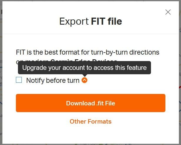
The track illustrated on the Edge 1000 to follow was exported from RWGPS. When I get the export option (either FIT or GPX) I get the following box that lets me check "notify before turn".
Is that not the option to "enable" TBT in the "file"?
Also, as noted from the dark gray highlight and orange carrot - the account has to be a paid-subscription to enable this feature.
When I upload the file from the above export to the Garmin - this is what the track looks like on the unit, zoomed in:

Note how the blue line is straight segments. That is how I created the route in RWGPS, exactly how it was created. It is not conforming to the road there.
As has been alluded to earlier - there appears to be a way to blend this route in with the roads/trails. I will have to look in to that and see if that does, in fact, work.
Now - when I enable that route to ride on it, and this is the same exact place on the map now - just with the ride "active" I get the following:

Note the purple line is also following the same route as was created, exactly, in RWGPS - segmented straight lines (sorry for the blur, but I think you can see the point I am making).
So now - what perplexes me even more, and this goes back to the option that was selectable (with a paid subscription - so I was not able to with a base/free subscription) on the file export page - I have no guidance.
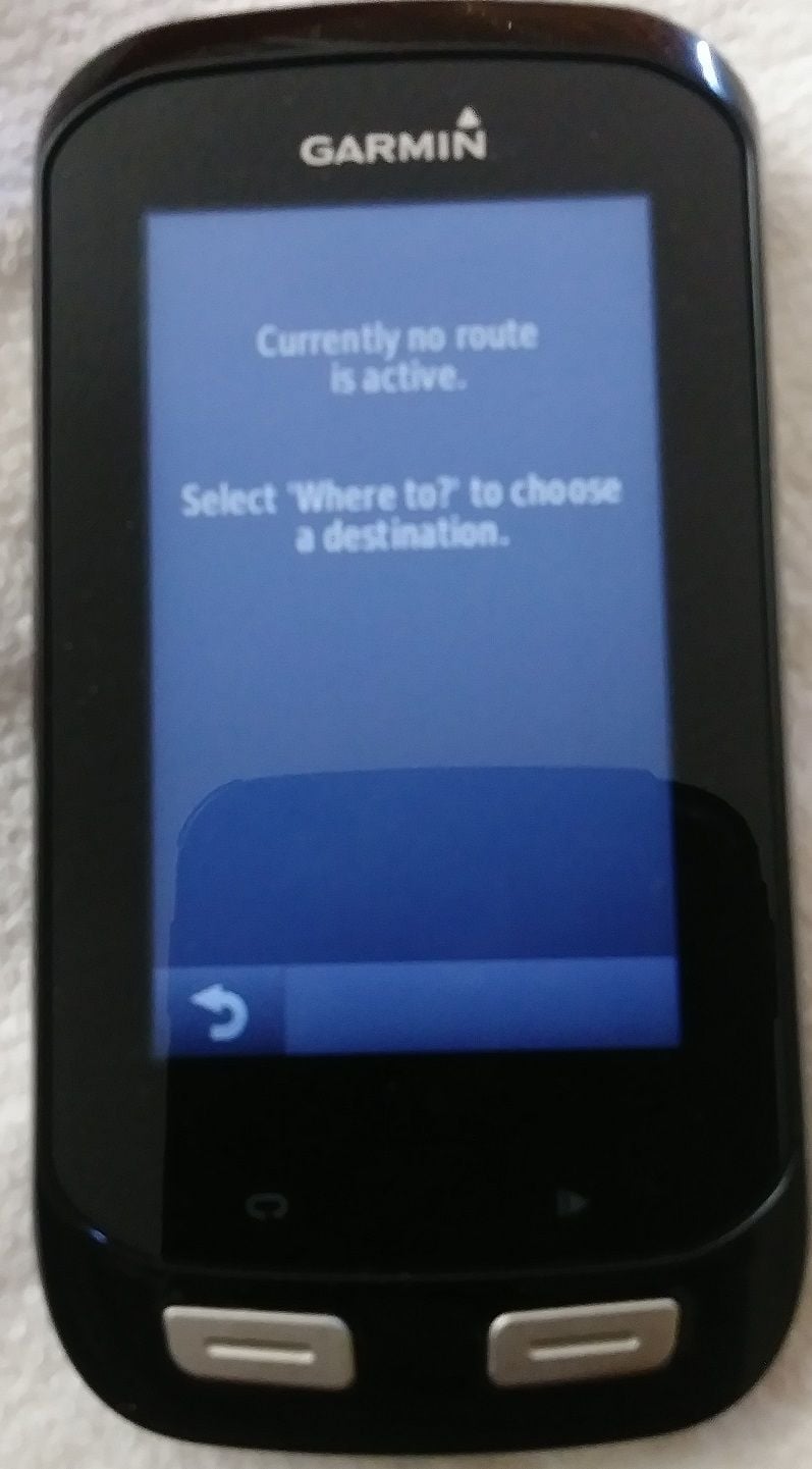
When I tap on the "navigate" tab on the top of my map screen with the above "active" route I get the following error message:
So if the Edge 1000 can do TBT routing internally regardless of the file - can you please tell me how I might enable that? I can create a test route the same way that would have the same theory in place if you or anyone else would like to test it to compare.
Thanks
The track illustrated on the Edge 1000 to follow was exported from RWGPS. When I get the export option (either FIT or GPX) I get the following box that lets me check "notify before turn".
Is that not the option to "enable" TBT in the "file"?
Also, as noted from the dark gray highlight and orange carrot - the account has to be a paid-subscription to enable this feature.
When I upload the file from the above export to the Garmin - this is what the track looks like on the unit, zoomed in:
Note how the blue line is straight segments. That is how I created the route in RWGPS, exactly how it was created. It is not conforming to the road there.
As has been alluded to earlier - there appears to be a way to blend this route in with the roads/trails. I will have to look in to that and see if that does, in fact, work.
Now - when I enable that route to ride on it, and this is the same exact place on the map now - just with the ride "active" I get the following:
Note the purple line is also following the same route as was created, exactly, in RWGPS - segmented straight lines (sorry for the blur, but I think you can see the point I am making).
So now - what perplexes me even more, and this goes back to the option that was selectable (with a paid subscription - so I was not able to with a base/free subscription) on the file export page - I have no guidance.
When I tap on the "navigate" tab on the top of my map screen with the above "active" route I get the following error message:
So if the Edge 1000 can do TBT routing internally regardless of the file - can you please tell me how I might enable that? I can create a test route the same way that would have the same theory in place if you or anyone else would like to test it to compare.
Thanks
11-01-19, 10:37 AM
#43
Senior Member
Join Date: Sep 2007
Location: Far beyond the pale horizon.
Posts: 14,259
Mentioned: 31 Post(s)
Tagged: 0 Thread(s)
Quoted: 4245 Post(s)
Liked 1,349 Times
in
936 Posts
You don't see it for GPX (you see it for FIT and TCX).
The road is straight line segments too.
The Garmin is using the OSM map. You may have created the route using a different map. Different maps often don't roads in exactly the same place.
In any case, this generally is not an issue.
I did that earlier:
Last edited by njkayaker; 11-01-19 at 12:40 PM.
11-02-19, 12:38 PM
#44
Senior Member
Join Date: Jan 2017
Posts: 1,064
Mentioned: 6 Post(s)
Tagged: 0 Thread(s)
Quoted: 350 Post(s)
Likes: 0
Liked 122 Times
in
90 Posts
I found locus map for Android to be the best out of the other apps that I've tried, because of the amount of features and customisation. Rwgps and komoot may generate better routes in some cases but they lack features.
What I like about locus maps is the automatic screen-on when nearing the next turn with ability to set the distance before the turn and also how long the screen stays on each time. There is also a hand waving feature that works with the IR proximity sensor but might not work if you keep the phone in a bag that doesn't allow IR to pass through.
Automatic rerouting. Off track warning and ability to set how far before it alerts. Variety of map types and ability to download offline cache or to load your own maps, overlaying multiple maps on top of each other with transparency, night mode for dark rendering, altitude shading rendering. Connect to various bt and ant sensors and customize your own overlay to display the real-time data over the map. Customize the buttons on the main screen. Track recording and analysis charts. Creating and saving of waypoints. Address search.
Route generation has options for riding style or road types.
Some of the offline options needs plugins. With so many functions, it takes many hours to get familiar with all of them, but that's what makes it good.
Last edited by tomtomtom123; 11-02-19 at 12:43 PM.
11-04-19, 11:56 PM
#45
Senior Member
Join Date: Mar 2010
Location: Seattle, WA
Posts: 23,208
Mentioned: 89 Post(s)
Tagged: 0 Thread(s)
Quoted: 18883 Post(s)
Liked 10,646 Times
in
6,054 Posts
It's a little bit of a pain at first (hopefully) worth it. It can be a black hole of time.
The editor I first learned to use (Potlatch 2) is sort-of going away (it's written in Flash). So, I have to learn another editor (ID).
Just start out making small changes. And make changes that represent "truth" rather than trying to fudge things to "get something to work". All sorts of people and things rely on your changes.
If a road really doesn't exist, you'd delete it.
"Ways" can be "tracks" (very primitive roads that are "drivable") or "generic paths" (hikeable, MTB-able).
PM me with the location.
This was from a course generated on the fly by the unit (random round trip function), I didn't save the course, only the record of the ride. I went back trying to find the non-road and wasn't able to ... I assume that means someone else already removed it.
