


American Canyon to Napa
 07-09-20, 12:07 AM
#1
Senior Member
Thread Starter

Join Date: Sep 2006
Location: Napa Valley, CA
Posts: 908
Bikes: Wife says I have too many :-)
Mentioned: 2 Post(s)
Tagged: 0 Thread(s)
Quoted: 327 Post(s)
Liked 250 Times
in
158 Posts
American Canyon to Napa
It sure would be nice to ride to Napa from American Canyon. They still haven't finished the segment along the Napa river that will wrap around the airport to give us passage to Napa without having to ride alongside the Napa Vallejo HWY. Someday, if I live long enough. 
 07-13-20, 08:27 AM
#2
Senior Member
Join Date: Jun 2013
Location: location location
Posts: 3,035
Bikes: MBK Super Mirage 1991, CAAD10, Yuba Mundo Lux, and a Cannondale Criterium Single Speed
Mentioned: 1 Post(s)
Tagged: 0 Thread(s)
Quoted: 344 Post(s)
Liked 297 Times
in
207 Posts
Commerce Blvd in AC has just been extended with a bike trail, no thru car traffic, so the day can't be far away where you can ride all the way down to the waterfront there, without getting on 29.
A few weekends ago I rode down to the AC side of the rail bridge at Brazos. If that was open to bike traffic, it'd be a game changer, but I somehow can't see the Milton Rd residents ever letting it happen.
07-13-20, 09:11 AM
#3
Senior Member
Thread Starter
Join Date: Sep 2006
Location: Napa Valley, CA
Posts: 908
Bikes: Wife says I have too many :-)
Mentioned: 2 Post(s)
Tagged: 0 Thread(s)
Quoted: 327 Post(s)
Liked 250 Times
in
158 Posts
It's coming along. From Napa You can ride through Kennedy Park, skirt the back of the homeless encampments, and connect to Kaiser Rd, and then Corporate Dr. Devlin Rd is connected all the way down to the Ikea fulfillment centre, and they're extending the roads down there. You can see the AmCan warehouses from there, so it can only be a matter of time.
Commerce Blvd in AC has just been extended with a bike trail, no thru car traffic, so the day can't be far away where you can ride all the way down to the waterfront there, without getting on 29.
A few weekends ago I rode down to the AC side of the rail bridge at Brazos. If that was open to bike traffic, it'd be a game changer, but I somehow can't see the Milton Rd residents ever letting it happen.
I will do some "exploratory" rides and check out the areas you mentioned. Especially Commerce Blvd. Thanks for the info. Maybe we could improvise a bicycle powered railroad track vehicle to scoot us over the rail bridge.
 07-13-20, 10:39 AM
#4
Senior Member
Join Date: Jun 2013
Location: location location
Posts: 3,035
Bikes: MBK Super Mirage 1991, CAAD10, Yuba Mundo Lux, and a Cannondale Criterium Single Speed
Mentioned: 1 Post(s)
Tagged: 0 Thread(s)
Quoted: 344 Post(s)
Liked 297 Times
in
207 Posts
Just had a look at my Strava from my ride down there; there's an incomplete, 1/2 mile extension to Devlin that takes you within what must only be a couple hundred yards of the back of the Biagi warehouse. And south of the end of that extension, they're building a bridge over the creek; the concrete deck is poured, and it just needs the roadway to connect to it. I'd be pretty sure looking at what they've got going there that a connection from Devlin to Green Island Rd can't be far off, and at that stage it'll be really close to feasible to bike all the way from Napa to Vallejo without going onto the highway.
07-13-20, 12:43 PM
#5
Senior Member
Thread Starter
Join Date: Sep 2006
Location: Napa Valley, CA
Posts: 908
Bikes: Wife says I have too many :-)
Mentioned: 2 Post(s)
Tagged: 0 Thread(s)
Quoted: 327 Post(s)
Liked 250 Times
in
158 Posts
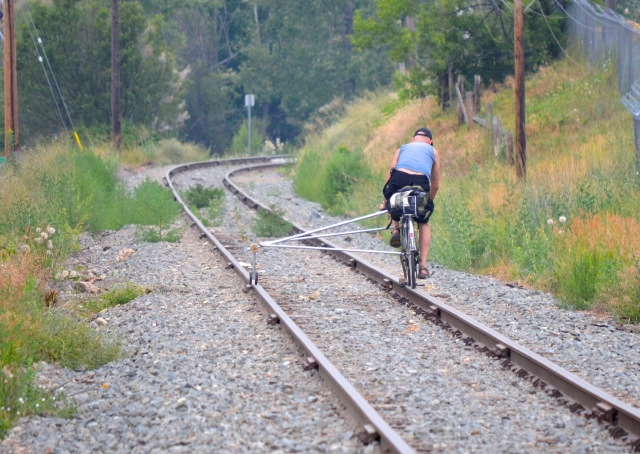
Something like this? I can see it working...
Just had a look at my Strava from my ride down there; there's an incomplete, 1/2 mile extension to Devlin that takes you within what must only be a couple hundred yards of the back of the Biagi warehouse. And south of the end of that extension, they're building a bridge over the creek; the concrete deck is poured, and it just needs the roadway to connect to it. I'd be pretty sure looking at what they've got going there that a connection from Devlin to Green Island Rd can't be far off, and at that stage it'll be really close to feasible to bike all the way from Napa to Vallejo without going onto the highway.
Just had a look at my Strava from my ride down there; there's an incomplete, 1/2 mile extension to Devlin that takes you within what must only be a couple hundred yards of the back of the Biagi warehouse. And south of the end of that extension, they're building a bridge over the creek; the concrete deck is poured, and it just needs the roadway to connect to it. I'd be pretty sure looking at what they've got going there that a connection from Devlin to Green Island Rd can't be far off, and at that stage it'll be really close to feasible to bike all the way from Napa to Vallejo without going onto the highway.
I like the train track cycle rig 😆. I�m going to check out the roadwork around Biagi. Sounds interesting and promising !!
07-13-20, 02:22 PM
#6
Senior Member
Thread Starter
Join Date: Sep 2006
Location: Napa Valley, CA
Posts: 908
Bikes: Wife says I have too many :-)
Mentioned: 2 Post(s)
Tagged: 0 Thread(s)
Quoted: 327 Post(s)
Liked 250 Times
in
158 Posts
Something like this? I can see it working...
Just had a look at my Strava from my ride down there; there's an incomplete, 1/2 mile extension to Devlin that takes you within what must only be a couple hundred yards of the back of the Biagi warehouse. And south of the end of that extension, they're building a bridge over the creek; the concrete deck is poured, and it just needs the roadway to connect to it. I'd be pretty sure looking at what they've got going there that a connection from Devlin to Green Island Rd can't be far off, and at that stage it'll be really close to feasible to bike all the way from Napa to Vallejo without going onto the highway.
Just had a look at my Strava from my ride down there; there's an incomplete, 1/2 mile extension to Devlin that takes you within what must only be a couple hundred yards of the back of the Biagi warehouse. And south of the end of that extension, they're building a bridge over the creek; the concrete deck is poured, and it just needs the roadway to connect to it. I'd be pretty sure looking at what they've got going there that a connection from Devlin to Green Island Rd can't be far off, and at that stage it'll be really close to feasible to bike all the way from Napa to Vallejo without going onto the highway.
I like the train track bicycle rig !
 I found what you are talking about on Google Maps with the Aerial view. Yeah it does indeed look like they are planning a tie in there. Google Maps may not have the most current view so I will check it out on the bike. Looks promising ! Assuming it does connect Devlin to Green Island Road, I get disoriented thinking about it, maybe there is a way to go north from Devlin to the trail above the airport that goes by Kennedy Park and up to Napa. Even if it won't be possible, being able to ride up to Devlin will cut a lot off of my HWY 29 riding. I can ride up to Devlin, take Devlin straight across 29 and ride the frontage road along 29 and tie back in to 29 quite a ways up. Then there is not a real long ride along 29 to the Napa College park entrance off 29 and then get on the trail behind the park and trail the rest of the way to Napa, yay ! Not sure if I am thinking correctly, but it all looks promising !
07-13-20, 02:49 PM
I found what you are talking about on Google Maps with the Aerial view. Yeah it does indeed look like they are planning a tie in there. Google Maps may not have the most current view so I will check it out on the bike. Looks promising ! Assuming it does connect Devlin to Green Island Road, I get disoriented thinking about it, maybe there is a way to go north from Devlin to the trail above the airport that goes by Kennedy Park and up to Napa. Even if it won't be possible, being able to ride up to Devlin will cut a lot off of my HWY 29 riding. I can ride up to Devlin, take Devlin straight across 29 and ride the frontage road along 29 and tie back in to 29 quite a ways up. Then there is not a real long ride along 29 to the Napa College park entrance off 29 and then get on the trail behind the park and trail the rest of the way to Napa, yay ! Not sure if I am thinking correctly, but it all looks promising !
07-13-20, 02:49 PM
#7
Senior Member
Join Date: Jun 2013
Location: location location
Posts: 3,035
Bikes: MBK Super Mirage 1991, CAAD10, Yuba Mundo Lux, and a Cannondale Criterium Single Speed
Mentioned: 1 Post(s)
Tagged: 0 Thread(s)
Quoted: 344 Post(s)
Liked 297 Times
in
207 Posts
Here's my Strava file for the ride I did down that way;
https://www.strava.com/activities/3460730142
As you can see, I took a bit of a detour before getting out of Kennedy, but if you come up from down south, take Kaiser road to the end and you should be able to navigate your way through along the side of the traintracks to the back of the park, by the softall fields/bmx track. Then you can cruise up the trail all the way to 3rd st and grab a pint at Stone!
You can also see just how close the Devlin extension gets to Green Island. You really only need to get on the highway between Green Island Rd and South Kelly (which connects to Devlin). Unfortunately that one stretch has no alternatives right now that I'm aware of. I would hope, hope, that the County transport planners, the Vine Trail people, etc are working out some sort of solution there for cyclists. I'd imagine if they are, that it's connected in some way with the Devlin extension.
Oh, and a word of warning, part of the Devlin stretch goes right past the dump. You'll be thankful of your facemask for that bit.
07-13-20, 09:23 PM
#8
Senior Member
Thread Starter
Join Date: Sep 2006
Location: Napa Valley, CA
Posts: 908
Bikes: Wife says I have too many :-)
Mentioned: 2 Post(s)
Tagged: 0 Thread(s)
Quoted: 327 Post(s)
Liked 250 Times
in
158 Posts
Here's my Strava file for the ride I did down that way;
https://www.strava.com/activities/3460730142
As you can see, I took a bit of a detour before getting out of Kennedy, but if you come up from down south, take Kaiser road to the end and you should be able to navigate your way through along the side of the traintracks to the back of the park, by the softall fields/bmx track. Then you can cruise up the trail all the way to 3rd st and grab a pint at Stone!
You can also see just how close the Devlin extension gets to Green Island. You really only need to get on the highway between Green Island Rd and South Kelly (which connects to Devlin). Unfortunately that one stretch has no alternatives right now that I'm aware of. I would hope, hope, that the County transport planners, the Vine Trail people, etc are working out some sort of solution there for cyclists. I'd imagine if they are, that it's connected in some way with the Devlin extension.
Oh, and a word of warning, part of the Devlin stretch goes right past the dump. You'll be thankful of your facemask for that bit.
https://www.strava.com/activities/3460730142
As you can see, I took a bit of a detour before getting out of Kennedy, but if you come up from down south, take Kaiser road to the end and you should be able to navigate your way through along the side of the traintracks to the back of the park, by the softall fields/bmx track. Then you can cruise up the trail all the way to 3rd st and grab a pint at Stone!
You can also see just how close the Devlin extension gets to Green Island. You really only need to get on the highway between Green Island Rd and South Kelly (which connects to Devlin). Unfortunately that one stretch has no alternatives right now that I'm aware of. I would hope, hope, that the County transport planners, the Vine Trail people, etc are working out some sort of solution there for cyclists. I'd imagine if they are, that it's connected in some way with the Devlin extension.
Oh, and a word of warning, part of the Devlin stretch goes right past the dump. You'll be thankful of your facemask for that bit.
Ha,ha yeah there is some aromatic stuff coming from the dump
 I traced the route from the end of Kaiser Road up and over to the trail on Google Maps Aerial view and it sure looks
doable ! I am going to check it out. The Devlin connection may be the ticket for our access to Napa, we will see. It will be fun checking out accessing the trail from Kaiser Road. Thanks for the info from your excursions through the area. Much appreciated !
