


degree of incline
 10-12-23, 12:50 PM
#1
Newbie
Thread Starter
Join Date: Jun 2023
Posts: 35
Mentioned: 0 Post(s)
Tagged: 0 Thread(s)
Quoted: 19 Post(s)
Likes: 0
Liked 24 Times
in
15 Posts
degree of incline
I've seen a lot of posts in different threads where riders talk about hills and degree of incline. Other than seeing a road side sign indicating the degree of the hill, how does one know that the degree is? Is there a method? I know that a twenty degree hill would mean that for every hundred feet the road rises twenty feet. I'm not saying that the knowledge of the degree will make it any easier to climb the hill, I am just curious. My ratings of hills goes from "this isn't too bad" to "OMG, why did I pick this road?"

Likes For spelger:
10-12-23, 01:56 PM
#3


Senior Member
Join Date: Jul 2005
Posts: 5,994
Mentioned: 26 Post(s)
Tagged: 0 Thread(s)
Quoted: 2495 Post(s)
Liked 739 Times
in
523 Posts
10-12-23, 02:17 PM
#4
I'm good to go!
Join Date: Jul 2017
Location: Mississippi
Posts: 14,992
Bikes: Tarmac Disc Comp Di2 - 2020
Mentioned: 51 Post(s)
Tagged: 0 Thread(s)
Quoted: 6196 Post(s)
Liked 4,810 Times
in
3,318 Posts
Grade just sounds better and gives us a larger number to deal with for our egos!
A 10% grade that makes us struggle climbing is only 5.7�. Even a 20% grade that we feel gives us bragging rights is only 11.3� <grin>
The formulas for various ways to figure slope/grade by percentage or degrees are here......
https://www.engineeringtoolbox.com/s...de-d_1562.html
There is a calculator you can plug in rise and run 1 or 2 clicks scrolling down. And a angular representation that shows what it looks like with the degrees and percentage shown below it.
There is a table a little further below the calculator that you can download and print out if it helps you for whatever you are doing.
Last edited by Iride01; 10-12-23 at 02:24 PM.
10-12-23, 02:22 PM
#5
climber has-been

Join Date: Dec 2004
Location: Palo Alto, CA
Posts: 7,111
Bikes: Scott Addict R1, Felt Z1
Mentioned: 10 Post(s)
Tagged: 0 Thread(s)
Quoted: 3432 Post(s)
Liked 3,567 Times
in
1,793 Posts
It�s a big world, so I guess it�s possible somewhere. Where was this?
__________________
Ride, Rest, Repeat. ROUVY: terrymorse

Ride, Rest, Repeat. ROUVY: terrymorse
Likes For terrymorse:
10-12-23, 02:55 PM
#6
Newbie
Thread Starter
Join Date: Jun 2023
Posts: 35
Mentioned: 0 Post(s)
Tagged: 0 Thread(s)
Quoted: 19 Post(s)
Likes: 0
Liked 24 Times
in
15 Posts
That may well be true, however I have (and the o.p. too, obviously) seen inclines expressed in degrees. The o.p. question is not wrong, degrees are a valid way of expressing incline. I've never been that interested in the details but I just found this with not that much time invested.
10-12-23, 02:59 PM
#7
Senior Member

Join Date: Oct 2011
Location: Ellensburg,WA
Posts: 3,180
Bikes: Schwinn Broadway, Specialized Secteur Sport(crashed) Spec. Roubaix Sport, Spec. Crux
Mentioned: 7 Post(s)
Tagged: 0 Thread(s)
Quoted: 179 Post(s)
Liked 169 Times
in
84 Posts
20� slope is 36.4 feet rise over 100 foot run. 20% slope is 11.31�
__________________
Sir Mark, Knight of Sufferlandria
Sir Mark, Knight of Sufferlandria
10-12-23, 03:03 PM
#9
Senior Member
Join Date: Jul 2015
Location: reno, nv
Posts: 2,301
Bikes: yes, i have one
Mentioned: 2 Post(s)
Tagged: 0 Thread(s)
Quoted: 1138 Post(s)
Liked 1,182 Times
in
687 Posts
That may well be true, however I have (and the o.p. too, obviously) seen inclines expressed in degrees. The o.p. question is not wrong, degrees are a valid way of expressing incline. I've never been that interested in the details but I just found this with not that much time invested.
Likes For spelger:
10-12-23, 03:47 PM
#11
Senior Member
Join Date: May 2021
Posts: 8,442
Mentioned: 12 Post(s)
Tagged: 0 Thread(s)
Quoted: 4414 Post(s)
Liked 4,867 Times
in
3,012 Posts
My Garmin tells me what the slope gradient is in real time. If I have a route loaded it also has any significant climbs listed with gradients and length etc.
Likes For PeteHski:
10-12-23, 08:37 PM
#12
It's MY mountain

Join Date: Sep 2006
Location: Mt.Diablo
Posts: 10,002
Bikes: Klein, Merckx, Trek
Mentioned: 70 Post(s)
Tagged: 0 Thread(s)
Quoted: 4338 Post(s)
Liked 2,981 Times
in
1,617 Posts
Roads are listed in percent grade because they are designed by engineers who are looking at flat maps with gradient lines on them, and the lines were mapped by surveyors. So they measure a length, and then they subtract the lower elevation line from the higher elevation line and get a percent grade. Also road construction manuals list maximum gradients for different types of roads, and those manuals are also written by engineers. Nobody is out there using protractors.
Most GPS computers will have a screen that shows current grade, but I think they use data rather than calculations. And if there's a Strava segment on your ride you can check it out there:
Here are some guidelines:
5% = maximum grade for an ADA bridge.
10% = a good climber can stay in the saddle
15% = a good climber can do it out of the saddle
20% = only the strongest climbers will be able to do it at all
25% = ridiculous grade used for exhibitions and contests
30% = almost nobody will make it up
Likes For DiabloScott:
10-13-23, 05:40 AM
#13
Senior Member
Yes always percentage never degrees for cycling or roads and trails in general. For rivers and streams ww paddlers use feet per mile or meters per kilometer as the usual measure.
 10-13-23, 07:27 AM
#14
Cheerfully low end
Join Date: Jun 2020
Posts: 1,978
Mentioned: 5 Post(s)
Tagged: 0 Thread(s)
Quoted: 646 Post(s)
Liked 1,044 Times
in
667 Posts
Here are some guidelines:
5% = maximum grade for an ADA bridge.
10% = a good climber can stay in the saddle
15% = a good climber can do it out of the saddle
20% = only the strongest climbers will be able to do it at all
25% = ridiculous grade used for exhibitions and contests
30% = almost nobody will make it up
5% = maximum grade for an ADA bridge.
10% = a good climber can stay in the saddle
15% = a good climber can do it out of the saddle
20% = only the strongest climbers will be able to do it at all
25% = ridiculous grade used for exhibitions and contests
30% = almost nobody will make it up
5% = stay in the saddle
10% = knees will be happier if I stand
15% = couldn�t stay in the saddle if I tried
over 15% = this is a good time for a walk.
Otto
10-13-23, 09:19 AM
#15
Senior Member
Join Date: Oct 2011
Location: Phx, AZ
Posts: 2,116
Bikes: Trek Mtn Bike
Mentioned: 5 Post(s)
Tagged: 0 Thread(s)
Quoted: 282 Post(s)
Liked 2,646 Times
in
952 Posts
I let Strava do it. You could possibly do it in google maps. Never worth it. No matter what uphill is hard! 
10-13-23, 10:43 AM
#16
climber has-been
Join Date: Dec 2004
Location: Palo Alto, CA
Posts: 7,111
Bikes: Scott Addict R1, Felt Z1
Mentioned: 10 Post(s)
Tagged: 0 Thread(s)
Quoted: 3432 Post(s)
Liked 3,567 Times
in
1,793 Posts
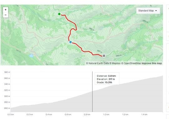
I did some steep but short climbs yesterday where Garmin displayed 15%, and up to 20% in short bits. Wanting to work my legs, I stayed in the saddle while doing a tempo power, but my cadence dropped to 50 much of the time. It wasn't that difficult aerobically, but my legs were much happier when the grade fell to "only" 11%.
A little steep segment from yesterday:
- distance: 0.14 mi
- av. grade: 14.6%
- av. speed: 5.0 mph
- av. cadence: 50
- av. power: 3.72 W/kg
__________________
Ride, Rest, Repeat. ROUVY: terrymorse
Ride, Rest, Repeat. ROUVY: terrymorse
10-13-23, 11:19 AM
#17
Senior Member
Join Date: May 2021
Posts: 8,442
Mentioned: 12 Post(s)
Tagged: 0 Thread(s)
Quoted: 4414 Post(s)
Liked 4,867 Times
in
3,012 Posts
A single speed? Yikes! I can't imagine doing double digit climbs on a single speed. My low gear is 34/28, and it's just about right for me on steep grades.
I did some steep but short climbs yesterday where Garmin displayed 15%, and up to 20% in short bits. Wanting to work my legs, I stayed in the saddle while doing a tempo power, but my cadence dropped to 50 much of the time. It wasn't that difficult aerobically, but my legs were much happier when the grade fell to "only" 11%.
A little steep segment from yesterday:
- distance: 0.14 mi
- av. grade: 14.6%
- av. speed: 5.0 mph
- av. cadence: 50
- av. power: 3.72 W/kg
Likes For PeteHski:
10-13-23, 03:40 PM
#18
climber has-been
Join Date: Dec 2004
Location: Palo Alto, CA
Posts: 7,111
Bikes: Scott Addict R1, Felt Z1
Mentioned: 10 Post(s)
Tagged: 0 Thread(s)
Quoted: 3432 Post(s)
Liked 3,567 Times
in
1,793 Posts

__________________
Ride, Rest, Repeat. ROUVY: terrymorse
Ride, Rest, Repeat. ROUVY: terrymorse
10-13-23, 04:09 PM
#19
Senior Member
Join Date: Oct 2008
Location: Portland, OR
Posts: 3,843
Bikes: Trek Domane SL6 Gen 3, Soma Fog Cutter, Focus Mares AL, Detroit Bikes Sparrow FG, Volae Team, Nimbus MUni
Mentioned: 11 Post(s)
Tagged: 0 Thread(s)
Quoted: 896 Post(s)
Liked 2,065 Times
in
1,081 Posts
Best to not use degrees, lest we really feel like wimps.
One might think a 20% grade is approaching 45 degrees, but it's a pedestrian sounding 11.3 degrees.
We are gravity challenged.
One might think a 20% grade is approaching 45 degrees, but it's a pedestrian sounding 11.3 degrees.
We are gravity challenged.
Likes For downtube42:
10-13-23, 05:11 PM
#20
Senior Member

Join Date: Feb 2008
Location: Peoria, IL
Posts: 4,476
Mentioned: 86 Post(s)
Tagged: 0 Thread(s)
Quoted: 1829 Post(s)
Liked 3,376 Times
in
1,580 Posts
For instance, this indicates about a 9% grade....
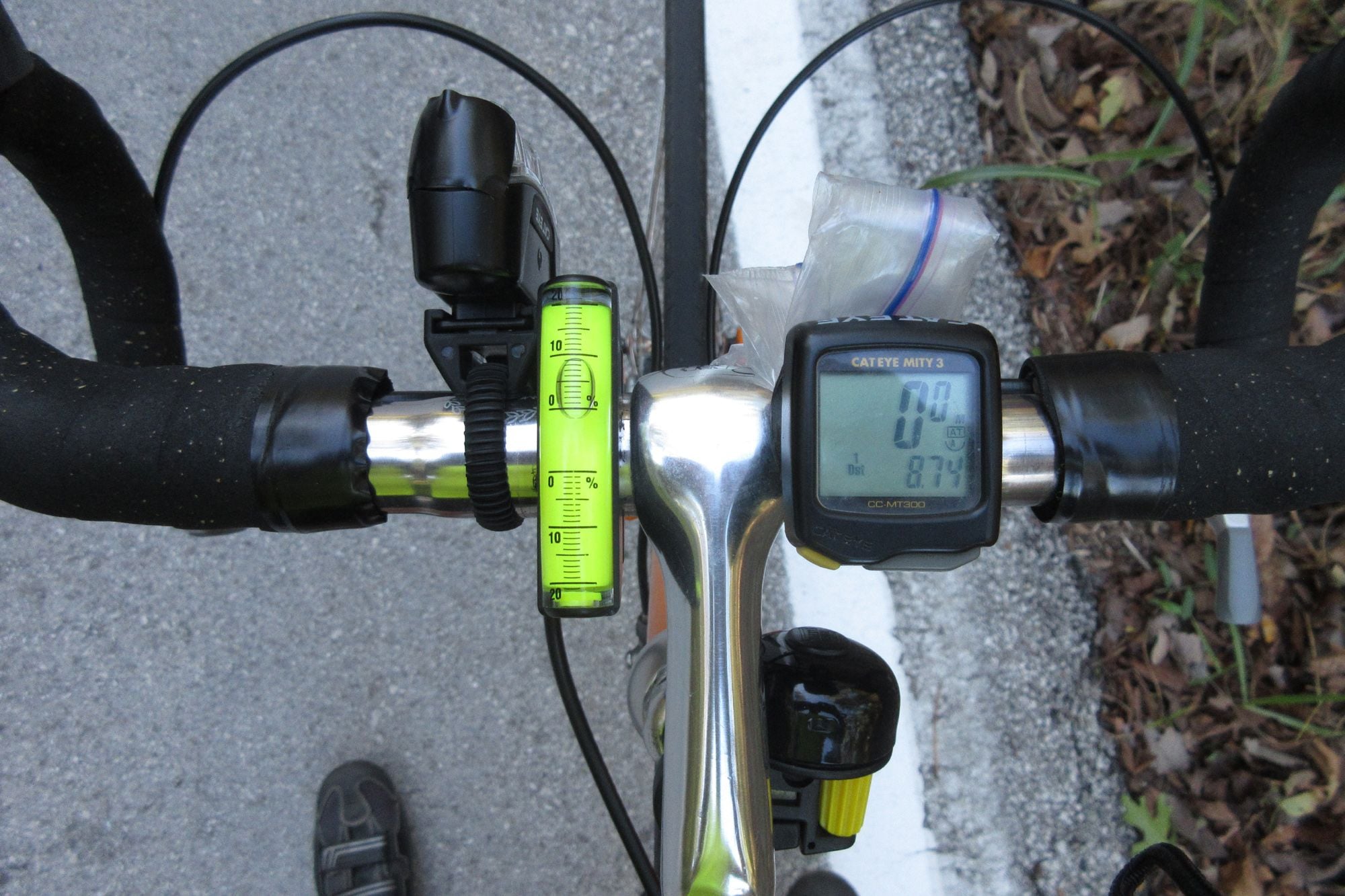
The best measurements are achieved when stopped, but you can get decent readings when riding too.
Steve in Peoria
Likes For steelbikeguy:
10-13-23, 05:26 PM
#21
just another gosling
Join Date: Feb 2007
Location: Everett, WA
Posts: 19,535
Bikes: CoMo Speedster 2003, Trek 5200, CAAD 9, Fred 2004
Mentioned: 115 Post(s)
Tagged: 0 Thread(s)
Quoted: 3889 Post(s)
Liked 1,938 Times
in
1,383 Posts
As to how we know, many if not most of us have a device on the bike which measures distance and elevation, does the math, and shows the percent of a climb on the screen as we ride up it. There are also occasional road signs which show percent, usually for the benefit of truckers on long descents.
On the other hand, backcountry skiers express slope angle in degrees to get some idea as to avalanche possibility. And we do carry little gadgets to measure slope angle.
__________________
Results matter
Results matter
10-13-23, 05:30 PM
#22
just another gosling
Join Date: Feb 2007
Location: Everett, WA
Posts: 19,535
Bikes: CoMo Speedster 2003, Trek 5200, CAAD 9, Fred 2004
Mentioned: 115 Post(s)
Tagged: 0 Thread(s)
Quoted: 3889 Post(s)
Liked 1,938 Times
in
1,383 Posts
.
__________________
Results matter
Results matter
10-13-23, 08:57 PM
#23
Grupetto Bob

Join Date: Sep 2020
Location: Seattle-ish
Posts: 6,222
Bikes: Bikey McBike Face
Mentioned: 2 Post(s)
Tagged: 0 Thread(s)
Quoted: 2584 Post(s)
Liked 5,642 Times
in
2,922 Posts
I've seen a lot of posts in different threads where riders talk about hills and degree of incline. Other than seeing a road side sign indicating the degree of the hill, how does one know that the degree is? Is there a method? I know that a twenty degree hill would mean that for every hundred feet the road rises twenty feet. I'm not saying that the knowledge of the degree will make it any easier to climb the hill, I am just curious. My ratings of hills goes from "this isn't too bad" to "OMG, why did I pick this road?"
__________________
Road 🚴🏾♂️ & Mountain 🚵🏾♂️
Road 🚴🏾♂️ & Mountain 🚵🏾♂️
10-13-23, 09:21 PM
#24
Senior Member
Join Date: May 2003
Location: Mountain Brook. AL
Posts: 4,002
Mentioned: 14 Post(s)
Tagged: 0 Thread(s)
Quoted: 303 Post(s)
Likes: 0
Liked 136 Times
in
104 Posts
I use ridewithgps to map out rides as do most of the ride leaders in my area (bike club discount) and have found it universally
understates slopes. On hills I know to be 10-12% ridewithgps never finds more than 6%. The overall elevation changes
are generally pretty close to others like Garmins, Wahoos and cell phone apps but the inclines are not.
My phone says my driveway is 24%, I can ride up it ok in 32/34 gearing, but it is only 30 yds or so.
10-13-23, 11:02 PM
#25
climber has-been
Join Date: Dec 2004
Location: Palo Alto, CA
Posts: 7,111
Bikes: Scott Addict R1, Felt Z1
Mentioned: 10 Post(s)
Tagged: 0 Thread(s)
Quoted: 3432 Post(s)
Liked 3,567 Times
in
1,793 Posts
I don�t think the Avocet displayed grade. The early Garmin units didn�t. I used to do math in my head to get a rough idea of the grade, and the rate of ascent (VAM). Having these on the display is quite the luxury.
__________________
Ride, Rest, Repeat. ROUVY: terrymorse
Ride, Rest, Repeat. ROUVY: terrymorse