


The "My all-time favorite rides" thread.
 04-25-12, 06:06 PM
#1
Chieftain
Thread Starter
Join Date: Feb 2008
Location: Oakland
Posts: 547
Bikes: 2012 Cannondale CAADX 105; Wabi Classic Fixed Gear
Mentioned: 0 Post(s)
Tagged: 0 Thread(s)
Quoted: 1 Post(s)
Likes: 0
Liked 0 Times
in
0 Posts
The "My all-time favorite rides" thread.
So my motivation for starting this thread is admittedly selfish, as I'm always looking for new rides (aren't we all) with good roads, scenery, etc. Share photos, maps, and directions, but save the epic photo essays of your weeklong epic from Monterey to Alturas for your blog.
Anyways, I think that most of us can benefit for a little refresher course of what's in our own backyard so I'll start:
1) Tour of the Unknown Coast - Ferndale, CA
https://www.tuccycle.org/
Follows Ave. of the Giants through old growth coastal redwoods, climbs Panther Gap, decend into Honeydew. Rollers to the coast via Petrolia, then many more climbs & descents back to Ferndale. A true back-roads epic. Unless you're riding the TUC (organized ride) be prepared to be completely self-supported and without cell. Nearly 10,000ft. of climbing!
2) "Standard Loop" - Oakland, CA
https://www.mapmyride.com/routes/view/85970979
Not really an epic, but my current "standard" for a two hour weekend or after work ride with some climbing. The route goes up Old Tunnel Rd and descends Pinehurst into Moraga. Take Moraga Blvd through Orinda, left on Wildcat Canyon Rd. At summit turn left on Grizzly Peak and descend via Claremont back to town.
3) Arcata to Patrick's Point Out and Back
(No map - sorry!)
One of my old favorites when I was in school at Humboldt. Mad River Rd. to Hammond Trail north. Continue on Clam Beach Rd. heading north till it ends at HWY 101. Get on 101 and take first exit towards Moonstone Beach. Go north on Scenic Drive into Trinidad. Take Stagecoach Dr. north to Patrick's Point Drive. End at Patrick's Point State Park. Retrace your directions back to Arcata and enjoy the tailwind!
YOUR TURN!
 04-25-12, 06:59 PM
#2
Senior Member
Join Date: Apr 2008
Location: San Francisco, CA
Posts: 1,076
Mentioned: 0 Post(s)
Tagged: 0 Thread(s)
Quoted: 0 Post(s)
Likes: 0
Liked 1 Time
in
1 Post
This Stanford loop is probably my favorite ride in the Bay area.
Stanford Loop: Peers Park->Page Mill Rd->Tunitas Creek->Old La Honda->Peers Park
Diablo Loop: Safeway (Ygnacio Valley Rd)->MorganTerritory->Camino Tassajara->SouthGate->Summit->Safeway
Stanford Loop: Peers Park->Page Mill Rd->Tunitas Creek->Old La Honda->Peers Park
Diablo Loop: Safeway (Ygnacio Valley Rd)->MorganTerritory->Camino Tassajara->SouthGate->Summit->Safeway
04-25-12, 11:27 PM
#3
Member

Join Date: Oct 2009
Location: Nor Cal
Posts: 825
Mentioned: 0 Post(s)
Tagged: 0 Thread(s)
Quoted: 0 Post(s)
Liked 0 Times
in
0 Posts
One of my favorite rides is an organized one: The Sonoma County Backroads Challenge
I did the 70 miler last year with the wife. It was awesome! Doing it again next month.
Another goodie (that is currently not doable on weekdays because of construction) is to start at Sunol-Ohlone Regional Park off of Calaveras Blvd (I-680). Head up Calaveras, left on Felter and then go up to the top where Felter meets Sierra Rd. If you're hardcore, descend Sierra Rd and then climb back up before heading back. I never get tired of the scenery out there.
Bob
04-26-12, 04:05 PM
#4
Full Member
Join Date: Aug 2010
Posts: 331
Mentioned: 0 Post(s)
Tagged: 0 Thread(s)
Quoted: 29 Post(s)
Likes: 0
Liked 11 Times
in
9 Posts
I assume you go from Safeway to Morgan Territory by taking Ygnacio directly to Clayton Rd. If so, how safe does it feel being on Ygnacio going over the hill with all those cars zooming around? If not, what route do you take?
04-26-12, 05:28 PM
#5
Senior Member
Join Date: Apr 2008
Location: San Francisco, CA
Posts: 1,076
Mentioned: 0 Post(s)
Tagged: 0 Thread(s)
Quoted: 0 Post(s)
Likes: 0
Liked 1 Time
in
1 Post
I love Morgan Territory from this direction though...it's so quiet in there...
04-27-12, 12:09 PM
#6
Full Member
Join Date: Aug 2010
Posts: 331
Mentioned: 0 Post(s)
Tagged: 0 Thread(s)
Quoted: 29 Post(s)
Likes: 0
Liked 11 Times
in
9 Posts
Yep, Ygnacio->Clayton...it's not great but the shoulder is ok and I try not to run it during heavy traffic times. Once you get over that first hill you can go backroads to Clayton as well if you want but I'll only do that if traffic seems bad. I honestly think the worse part of the route is the stretch on Camino Tassajara heading to Blackhawk/South Gate. There's no shoulder off/on and traffic always seems a mess over there...the upside is it's a pretty short stretch.
I love Morgan Territory from this direction though...it's so quiet in there...
I love Morgan Territory from this direction though...it's so quiet in there...
I've done Camino Tassajara heading to Blackhawk/South Gate, although only early morning on weekends, but if it Ygnacio over the hills isn't worse than that if I avoid heavy traffic times, I can probably deal with it.
I'm mostly interested because I would like to try Morgan Territory from the north. I've only gone up and back down from the south, in the near future it will be time to do north to south as part of a loop.
04-28-12, 12:15 AM
#7
Member
Join Date: Oct 2009
Location: Nor Cal
Posts: 825
Mentioned: 0 Post(s)
Tagged: 0 Thread(s)
Quoted: 0 Post(s)
Liked 0 Times
in
0 Posts
The north side (Concord side) is not nearly as steep (especially near the bottom) as the south side, but watch out for the bumps! The south side is very smooth in comparison.
Bob
Bob
04-28-12, 09:21 AM
#8
Senior Member

Join Date: May 2008
Posts: 870
Mentioned: 0 Post(s)
Tagged: 0 Thread(s)
Quoted: 74 Post(s)
Likes: 0
Liked 3 Times
in
1 Post
Tunitas Creek Road is my number 1 (going up of course)
Alpine Road to Skyline is number 2 (going up of course)
Bolinas Fairfax Road is my number 3 (going up of course from both sides)
Alpine Road to Skyline is number 2 (going up of course)
Bolinas Fairfax Road is my number 3 (going up of course from both sides)
05-01-12, 11:44 AM
#9
Erect member since 1953

Join Date: Dec 2006
Location: Antioch, CA (SF Bay Area)
Posts: 7,000
Bikes: Trek 520 Grando, Roubaix Expert, Motobecane Ti Century Elite turned commuter, Some old French thing gone fixie
Mentioned: 8 Post(s)
Tagged: 0 Thread(s)
Quoted: 121 Post(s)
Likes: 0
Liked 38 Times
in
21 Posts
Great question. I love the local stuff. Three Bears variations. Anything that goes through Canyon. Calavaras Road is a fine addition to any ride, and Diablo is always good.
But thinking about my favorite. That's harder. The two most amazing rides I've been on were:
1. The ride around Crater Lake. It's so very stunning. Not epic in distance or climbing (if you start at the lake), but so very worth the trip.
2. We rode through Yellowstone last summer and I couldn't believe it. All those photos that look liek a photographer found the perfect spot and waited forever to get a grand shot? It's like that everywhere. Every few miles I was saying "This alone is worth the whole trip."
The only only other place that comes close to these two is the bike path in Antioch, where they scatter diamonds and other jewels along the way. They sparkle like you wouldn't believe. Sure, they get caught in your tires sometimes, but you can always sell them later. Here's one I caught just the other day.
05-01-12, 11:52 AM
#10
Senior Member
Join Date: Nov 2006
Posts: 169
Mentioned: 0 Post(s)
Tagged: 0 Thread(s)
Quoted: 0 Post(s)
Likes: 0
Liked 0 Times
in
0 Posts
Nacimiento-Fergusson.... !!!!!
https://www.toughascent.com/blog/?p=102
https://www.toughascent.com/blog/?p=102
05-12-12, 11:49 AM
#11
Senior Member

Join Date: Nov 2007
Location: CenCal - SLO
Posts: 710
Bikes: S2, Wilier GTR (Arr), Giant VT, Myata 3-10
Mentioned: 0 Post(s)
Tagged: 0 Thread(s)
Quoted: 17 Post(s)
Likes: 0
Liked 6 Times
in
3 Posts
Cohasset and Honeyrun (with some mods)
https://chicocorsa.com/rides/
Antioch - Clayton loop through Black Diamond Preserve (mtn biked)
https://www.ebparks.org/parks/black_diamond
Los Osos - San Simeon out&back, with variations
https://chicocorsa.com/rides/
Antioch - Clayton loop through Black Diamond Preserve (mtn biked)
https://www.ebparks.org/parks/black_diamond
Los Osos - San Simeon out&back, with variations
05-14-12, 05:14 PM
#12
Senior Member
Join Date: Oct 2004
Location: CA SF Bay Area
Posts: 476
Bikes: 2014 CDale EVO, 2007 System Six, 2004 Litespeed Solano, 2002 Burley Duet
Mentioned: 3 Post(s)
Tagged: 0 Thread(s)
Quoted: 92 Post(s)
Likes: 0
Liked 0 Times
in
0 Posts
Suisun Valley- Mt George- Silverado Trail- Hwy128 to Berryesea- Back down Hwy121/Wooden Valley to Suisun Valley.
Benicia- Martinez- Alhamba Valley Rd- Pinole Valley- San Pablo- Carquinez Bridge- Benicia. (Or add the Bears and San Pablo for an extra 20 miles)
Benicia- Martinez- Alhamba Valley Rd- Pinole Valley- San Pablo- Carquinez Bridge- Benicia. (Or add the Bears and San Pablo for an extra 20 miles)
05-14-12, 10:03 PM
#13
Senior Member

Join Date: Aug 2007
Location: Monterey Bay Area
Posts: 477
Mentioned: 0 Post(s)
Tagged: 0 Thread(s)
Quoted: 0 Post(s)
Likes: 0
Liked 0 Times
in
0 Posts
A long time favorite is from when I lived in Gilroy, don't remember the exact route but it went up around Uvas and then across 101 towards Gilroy Hot Springs.
05-14-12, 10:39 PM
#14
:p
Join Date: Feb 2008
Location: bay area
Posts: 356
Mentioned: 0 Post(s)
Tagged: 0 Thread(s)
Quoted: 1 Post(s)
Likes: 0
Liked 0 Times
in
0 Posts
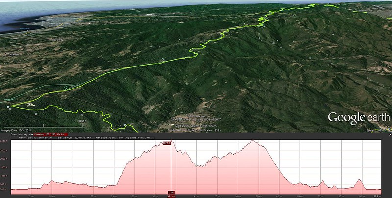
I've only done it a couple times, but riding nearly all of the Santa Cruz mountain ridge via Summit Road is definitely near the top of my list of favorite rides. The times I've done it were on 23mm road tires, which made climbing some of the unpaved gravel sections... interesting. The views are worth it though.
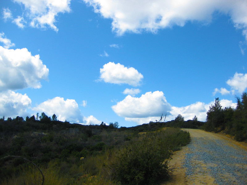
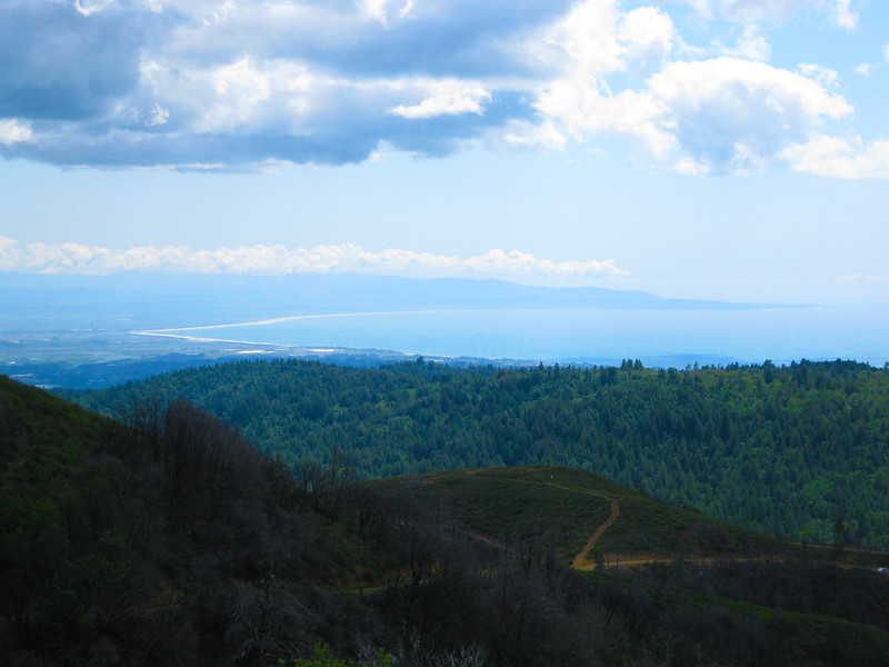
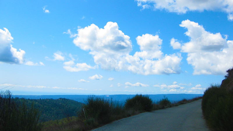
what the route looks like from google earth:
what the route looks like from google earth:
05-15-12, 08:58 AM
#16
:p
Join Date: Feb 2008
Location: bay area
Posts: 356
Mentioned: 0 Post(s)
Tagged: 0 Thread(s)
Quoted: 1 Post(s)
Likes: 0
Liked 0 Times
in
0 Posts
Just a run-of-the-mill Canon point&shoot. It's takes 10 megapixel photos so they are nice and crisp. I'm thinking about getting a wide-angle camera so I can get more of the 'land' in the landscape photos I take.
03-15-15, 10:13 PM
#17
Junior Member
2) "Standard Loop" - Oakland, CA
Standard Plus Grizzly Peak in Oakland, CA, United States | MapMyRide
Not really an epic, but my current "standard" for a two hour weekend or after work ride with some climbing. The route goes up Old Tunnel Rd and descends Pinehurst into Moraga. Take Moraga Blvd through Orinda, left on Wildcat Canyon Rd. At summit turn left on Grizzly Peak and descend via Claremont back to town.
Hey Humboldt'sRoads,
Thanks for sharing your ride! I normally ride in SF, Marin and the Peninsula, but had 2 1/2 hours to ride today from Oakland Tech HS, and did a slightly modified version of your "Standard Loop" - fantastic! This ride had it all - good climbing; fun descents; tremendous urban and rural views; great mix of surroundings; redwoods, oaks, streams, and other natural beauty; and mostly on roads with very little traffic. This ride also shares a quality with many of my favorite bay area rides - The Marin Headlands, the Alpine Dam Loop, Palomares Road near Sunol - they all give a feeling of wonderment, that a place of such beauty, largely unknown, exists so close to the rest of civilization.
I even read up afterwards on little unincorporated Canyon CA along Pinehurst Rd., home to a 70 child K-8 school and a Post Office dating to 1922, back when logging and a train along the San Leandro Creek had the area bustling. https://www.strava.com/activities/268897480
03-15-15, 10:25 PM
#18
Senior Member
Yep, Ygnacio->Clayton...it's not great but the shoulder is ok and I try not to run it during heavy traffic times. Once you get over that first hill you can go backroads to Clayton as well if you want but I'll only do that if traffic seems bad. I honestly think the worse part of the route is the stretch on Camino Tassajara heading to Blackhawk/South Gate. There's no shoulder off/on and traffic always seems a mess over there...the upside is it's a pretty short stretch.
I love Morgan Territory from this direction though...it's so quiet in there...
I love Morgan Territory from this direction though...it's so quiet in there...

