


Using just a compass for navigation
 02-22-21, 01:39 PM
#26
Senior Member
Join Date: Dec 2010
Location: northern Deep South
Posts: 8,899
Bikes: Fuji Touring, Novara Randonee
Mentioned: 36 Post(s)
Tagged: 0 Thread(s)
Quoted: 2601 Post(s)
Liked 1,925 Times
in
1,208 Posts
My wife and I found that to be true. On this day in Appalachians, we rode over 3 hills that where a lot tougher than any thing we had to climb since leaving the west coast. This was the fourth hill that day, and I just pulled over and put my running shoes on and walked up it. As it turned out it was the last of the hard hills. The first thing I did when we got home was to change the 48/36/26 cranks to 44/32/22. It made a world of difference.


 02-22-21, 04:18 PM
#27
Senior Member

Join Date: Aug 2005
Posts: 3,867
Mentioned: 14 Post(s)
Tagged: 0 Thread(s)
Quoted: 595 Post(s)
Liked 282 Times
in
193 Posts
Even in this day of smart phones and gps, I still always travel with a small compass "just in case". In certain terrain, it's easy to get turned around when the roads aren't straight and flat. More than once I have referred to that little red needle to confirm my desired direction.
02-22-21, 04:45 PM
#29
Senior Member
Join Date: Nov 2014
Location: Ann Arbor Michigan
Posts: 152
Bikes: miyata 83 1000,84 1000,83 610,88 ridge runner ,Schwinn 84 high sierra,88 Cimmeron,86 Passage,84 Stumplumper ,83 Mt Whitney,83 Trek 850,Merckx Century,PX10, RB1,XO 1 XO 4,bunch of stuff like that
Mentioned: 4 Post(s)
Tagged: 0 Thread(s)
Quoted: 57 Post(s)
Liked 51 Times
in
42 Posts
compass
I always bring along a compass especially when Im trail riding far from home in the back country or even some bigger parks. .Its easy to get caught up and forget how many turns you made or which trail youre even on.GPS wont work out there.
02-22-21, 04:55 PM
#30
Full Member
The biggest problem with a compass is that the roads are not E-W or N-S and can loop back on themselves 180 Degrees. A high percentage of the roads are narrow, congested and without shoulders. Without a map or damned good knowledge of the area you will end up on some really frightening roads. Even to drive them is white knuckle. Throw in some Amish buggies, logging trucks and coal trucks and you have a recipe for being involved in a head on or side swiped. Half of them don't have insurance and are not going to stop.
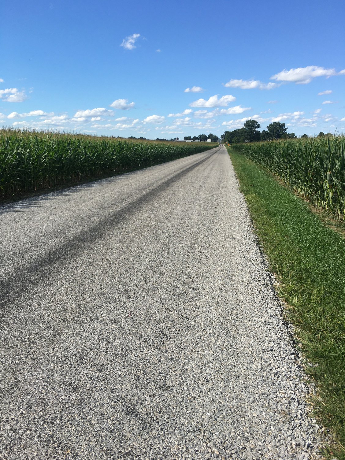
Here is a really tame road near where I live in Eastern Ohio that I ride often in the summer. This is chip and seal 16 feet wide, no centerline or edge lines. The corn is planted to within one foot of the road on one side and on the other side is a deep narrow ditch with the tops of the grass and thistles mowed flat. You go in the corn to pass a Combine and in a car, you backup and find a side road or driveway. I took this photo because it was relatively flat and showed what East Ohio is like. All roads follow the terrain here. There is no leveling or grading done. These roads existed before cars and so did the rite-of-ways. This is still 100 miles west of Appalachia. With an ACA map and a compass and you stand a chance of not getting killed. Google is a crap shoot.
 02-22-21, 05:27 PM
#31
Senior Member
The Mass Pike, which is, I believe, US-90, has a sign in western Mass telling you that you are nine hundred odd feet above sea level, and that that is the highest point on the road until somewhere in Nebraska. You can't ride on the interstate, of course, but I'll bet it is paralleled by rideable roads. That would avoid Appalachia.
02-22-21, 05:39 PM
#32
Palmer

Join Date: Mar 2007
Location: Parts Unknown
Posts: 8,610
Bikes: Mike Melton custom, Alex Moulton AM, Dahon Curl
Mentioned: 37 Post(s)
Tagged: 0 Thread(s)
Quoted: 1660 Post(s)
Liked 1,814 Times
in
1,054 Posts
Here in Parts Unknown nearly all the road signs indicate which general direction they head.
The river thing: your road T-intersects at a river rather than crosses. Two miles to the bridge in one direction, 27 miles in the other. A compass will be about as helpful as flipping a coin.
The river thing: your road T-intersects at a river rather than crosses. Two miles to the bridge in one direction, 27 miles in the other. A compass will be about as helpful as flipping a coin.
 02-22-21, 05:44 PM
#33
Palmer
Join Date: Mar 2007
Location: Parts Unknown
Posts: 8,610
Bikes: Mike Melton custom, Alex Moulton AM, Dahon Curl
Mentioned: 37 Post(s)
Tagged: 0 Thread(s)
Quoted: 1660 Post(s)
Liked 1,814 Times
in
1,054 Posts
On a 'dead reckoning' tour several decades ago our delightful country lane dump us off on a full legal speed +, heavily trafficked, no shoulder highway. Hey, it went in the right direction. 
02-22-21, 05:47 PM
#34
bicycle tourist
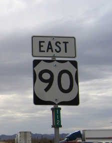
The Mass Pike is I-90 also shown here: https://en.wikipedia.org/wiki/Interstate_90. I think on average, E-W interstates are numbered with even numbers with higher numbers further north.
US 90 is a different road as shown here: https://en.wikipedia.org/wiki/U.S._Route_90. I think on average US routes are numbered with even numbers with higher numbers further south.
I've cycled large portions of US 90 and it would get you a pretty good route across. As other photos have shown, it is marked with "east" and "west" signs. From the Western terminus at Van Horne, you could follow I-10 most all the rest of the way until you got close to urban parts of California. Not the most pleasant riding but fairly direct.
02-22-21, 06:00 PM
#35
Palmer
Join Date: Mar 2007
Location: Parts Unknown
Posts: 8,610
Bikes: Mike Melton custom, Alex Moulton AM, Dahon Curl
Mentioned: 37 Post(s)
Tagged: 0 Thread(s)
Quoted: 1660 Post(s)
Liked 1,814 Times
in
1,054 Posts
 02-22-21, 06:06 PM
#36
Full Member
The Mass Pike, which is, I believe, US-90, has a sign in western Mass telling you that you are nine hundred odd feet above sea level, and that that is the highest point on the road until somewhere in Nebraska. You can't ride on the interstate, of course, but I'll bet it is paralleled by rideable roads. That would avoid Appalachia.
You don't know your geography and hit the wrong area following a compass and local directions to cross the Appalachians and you can be in for some real hair raising riding. There is substantial population on both sides of the Appalachians and not the may good roads that cross reasonably direct so the traffic is high. The areas are depressed so the roads and zoning are poor.
02-22-21, 06:27 PM
#37
Full Member
Try using google streetview in rural Appalachia. It's very spotty
Its very hard to get good local directions further than a few miles. traveling for me on business in that area back in the 80's was a real eye opener. The nastier you kit the better directions you are likely to get.
02-23-21, 06:44 AM
#38
Senior Member
Join Date: Aug 2010
Location: Madison, WI
Posts: 11,197
Bikes: 1961 Ideor, 1966 Perfekt 3 Speed AB Hub, 1994 Bridgestone MB-6, 2006 Airnimal Joey, 2009 Thorn Sherpa, 2013 Thorn Nomad MkII, 2015 VO Pass Hunter, 2017 Lynskey Backroad, 2017 Raleigh Gran Prix, 1980s Bianchi Mixte on a trainer. Others are now gone.
Mentioned: 48 Post(s)
Tagged: 0 Thread(s)
Quoted: 3458 Post(s)
Liked 1,465 Times
in
1,143 Posts
After I retired and was packing for my first trip to Europe, I was trying to pack light so I did not want any redundancies. Decided since my watch had a built in compass, no need to carry a separate one. Sitting on the plane before take off, I push a button on my watch to start to change time zones and get a low battery warning. Thus, for that trip, no alarm clock, no compass. At least the watch still told time. And my flip phone was certainly useless for such features too.
That was the only trip where I did not take a compass, always take one now. Even when I take a smartphone and a GPS, still carry a compass.
Regarding the sun, that does work for direction on days when it is not cloudy, but I think my Florida trip was the only trip I ever took that had reliable sunlight.
02-23-21, 07:53 AM
#39
Palmer
Join Date: Mar 2007
Location: Parts Unknown
Posts: 8,610
Bikes: Mike Melton custom, Alex Moulton AM, Dahon Curl
Mentioned: 37 Post(s)
Tagged: 0 Thread(s)
Quoted: 1660 Post(s)
Liked 1,814 Times
in
1,054 Posts
 02-23-21, 08:05 AM
#40
Senior Member
Join Date: Aug 2010
Location: Madison, WI
Posts: 11,197
Bikes: 1961 Ideor, 1966 Perfekt 3 Speed AB Hub, 1994 Bridgestone MB-6, 2006 Airnimal Joey, 2009 Thorn Sherpa, 2013 Thorn Nomad MkII, 2015 VO Pass Hunter, 2017 Lynskey Backroad, 2017 Raleigh Gran Prix, 1980s Bianchi Mixte on a trainer. Others are now gone.
Mentioned: 48 Post(s)
Tagged: 0 Thread(s)
Quoted: 3458 Post(s)
Liked 1,465 Times
in
1,143 Posts
I have seen those types of compasses. Several years ago, bought a bell that had a built in compass. The steel in the steerer tube, steel screws in stem, steel star nut, steel stem cap bolt all threw it off too much to be useable.
Plus, want one that I can carry while walking during sightseeing. That trip where my compass in my watch did not work, I had an old GPS and walking in the old part of Prague where roads were narrow between the buildings, my GPS had trouble picking up satellites because of the tall buildings and limited unobstructed sky. Wished I had a compass in my pocket that day, kept getting lost in the narrow streets.
Plus, want one that I can carry while walking during sightseeing. That trip where my compass in my watch did not work, I had an old GPS and walking in the old part of Prague where roads were narrow between the buildings, my GPS had trouble picking up satellites because of the tall buildings and limited unobstructed sky. Wished I had a compass in my pocket that day, kept getting lost in the narrow streets.
02-23-21, 09:24 AM
#41
Senior Member
Join Date: Dec 2010
Location: northern Deep South
Posts: 8,899
Bikes: Fuji Touring, Novara Randonee
Mentioned: 36 Post(s)
Tagged: 0 Thread(s)
Quoted: 2601 Post(s)
Liked 1,925 Times
in
1,208 Posts
{If} You don't know your geography and hit the wrong area following a compass and local directions to cross the Appalachians and you can be in for some real hair raising riding. There is substantial population on both sides of the Appalachians and not the may good roads that cross reasonably direct so the traffic is high.
I'm not sure a cellphone is a viable route planning tool for this backroads network. Leaving aside the question of cell coverage, Route 666 west, that lovely cycling road, may go east for a couple miles before it turns back west, and if you zoom out to see where it goes, it's a small road that disappears from the map. Better to plan ahead and lock in a route than to rely on a compass, with or without a cell phone!
02-23-21, 11:21 AM
#42
Full Member
I disagree, the Appalachians are not the monolothic block you portray.
On the other hand, if either you have some knowledge of the area, or else have some good maps and understanding of where you want to go west (or east), it's possible to develop some viable routes. Sure, you need to follow a few rules, such as avoid major roads going into large towns or cities at rush hour, or don't go near large parks around holidays or weekends. And if you're arguing that finding a good route is difficult with just a compass, I agree completely. But most of the Appalachians are covered in a network of lightly traveled back roads that are largely fine for bicycling.
I'm not sure a cellphone is a viable route planning tool for this backroads network. Leaving aside the question of cell coverage, Route 666 west, that lovely cycling road, may go east for a couple miles before it turns back west, and if you zoom out to see where it goes, it's a small road that disappears from the map. Better to plan ahead and lock in a route than to rely on a compass, with or without a cell phone!
02-23-21, 04:30 PM
#43
Senior Member
i recall a couple of spots crossing the blue ridge, highways coming from
different directions would converge, being routed together, you could be
going both north and south traveling in the same direction.
there was one highway with three routes together, with signs indicating
one was concurrently traveling east, south and north.
as to telling direction:
https://itotd.com/articles/2411/13-w...-in-the-woods/
https://pursuingoutdoors.com/tell-di...thout-compass/
and about crossing the missississiissipppi:
https://www.wikihow.com/Build-Rafts
https://th.bing.com/th/id/R016f70014...sl=&pid=ImgRaw
Last edited by saddlesores; 02-23-21 at 05:06 PM.
02-23-21, 05:17 PM
#44
Senior Member
Join Date: Oct 2014
Location: Portland, OR
Posts: 12,902
Bikes: (2) ti TiCycles, 2007 w/ triple and 2011 fixed, 1979 Peter Mooney, ~1983 Trek 420 now fixed and ~1973 Raleigh Carlton Competition gravel grinder
Mentioned: 129 Post(s)
Tagged: 0 Thread(s)
Quoted: 4802 Post(s)
Liked 3,922 Times
in
2,551 Posts
Crossing the country without a compass? First, I'm betting that it was done on foot before "discovery" by Columbus. It is known that a member of the Nez Perce tribe traveled to Cincinnati Ohio then home via Arizona and California. (No written record, but legends of this journey have been passed down by both the Nez Perce, the Cincinnati tribe and other tribes along the route.)
This planet has been circumnavigated without a compass or any other instruments. By an American, Professor Marvin Creamer, 1982. No timepiece, no sextant, no radio. A modern sailing yacht but all navigation was done with tools available before the written word. (Stars, sun, sky, weather, water colors and waves, birds, fish and animals, smells ...)
This planet has been circumnavigated without a compass or any other instruments. By an American, Professor Marvin Creamer, 1982. No timepiece, no sextant, no radio. A modern sailing yacht but all navigation was done with tools available before the written word. (Stars, sun, sky, weather, water colors and waves, birds, fish and animals, smells ...)
02-23-21, 05:23 PM
#45
The dropped

Join Date: Oct 2018
Location: Columbus, OH
Posts: 2,144
Bikes: Pake C'Mute Touring/Commuter Build, 1989 Kona Cinder Cone, 1995 Trek 5200, 1973 Raleigh Super Course FG, 1960/61 Montgomery Ward Hawthorne "thrift" 3 speed, by Hercules (sold) : 1966 Schwinn Deluxe Racer (sold)
Mentioned: 10 Post(s)
Tagged: 0 Thread(s)
Quoted: 1739 Post(s)
Liked 1,014 Times
in
696 Posts
Crossing the country without a compass? First, I'm betting that it was done on foot before "discovery" by Columbus. It is known that a member of the Nez Perce tribe traveled to Cincinnati Ohio then home via Arizona and California. (No written record, but legends of this journey have been passed down by both the Nez Perce, the Cincinnati tribe and other tribes along the route.)
This planet has been circumnavigated without a compass or any other instruments. By an American, Professor Marvin Creamer, 1982. No timepiece, no sextant, no radio. A modern sailing yacht but all navigation was done with tools available before the written word. (Stars, sun, sky, weather, water colors and waves, birds, fish and animals, smells ...)
This planet has been circumnavigated without a compass or any other instruments. By an American, Professor Marvin Creamer, 1982. No timepiece, no sextant, no radio. A modern sailing yacht but all navigation was done with tools available before the written word. (Stars, sun, sky, weather, water colors and waves, birds, fish and animals, smells ...)
02-23-21, 05:44 PM
#46

Veteran, Pacifist

Join Date: Dec 2004
Location: Seattle area
Posts: 13,327
Bikes: Bikes??? Thought this was social media?!?
Mentioned: 284 Post(s)
Tagged: 0 Thread(s)
Quoted: 3898 Post(s)
Liked 4,830 Times
in
2,228 Posts
Is this a clothing optional question?
Compass and my Looks and I might make it, Southern Route but only if sagged with enough suntan lotion. What's the prize? = big money?
Compass and my Looks and I might make it, Southern Route but only if sagged with enough suntan lotion. What's the prize? = big money?
__________________
Vintage, modern, e-road. It is a big cycling universe.
Vintage, modern, e-road. It is a big cycling universe.
02-26-21, 06:01 PM
#47
Senior Member
That is all I use, paper maps and a compass, especially in the outback. A lot of really remote roads, are not even on the map, or on google maps style devices. ,
02-26-21, 10:10 PM
#48
Full Member
