


App to let me pre-select roads from home?
 10-22-18, 02:17 PM
#1
Senior Member
Thread Starter
Join Date: Oct 2005
Location: SW Ohio
Posts: 3,682
Bikes: Puch Marco Polo, Saint Tropez, Masi Gran Criterium
Mentioned: 25 Post(s)
Tagged: 0 Thread(s)
Quoted: 1163 Post(s)
Liked 442 Times
in
315 Posts
App to let me pre-select roads from home?
I thought Map My Ride allowed you to look at a map, click on specific roads which become highlighted, then you click on the save button. Once your partial rout is saved, you can continue until you reach your endpoint. I’m pretty sure our cycling club leader does this and then we can view the route ahead of time.
so I downloaded Map My Ride by Underarmour. I looked at the app and it looks like Endomondo - more of a GPS fitness tracker. Did I download the wrong version 0f Map My Ride? I was under the impression that setting up custom directions for a ride would be fairly straightforward. Am I missing some custom feature of this app? Do I need to purchase the upgraded version?
Any help folks can provide here on how to properly establish routes with Map My Ride to save (for a 4 day mini-tour I am planning later this week) would be much appreciated.
 10-22-18, 02:26 PM
#2

Senior Member
Join Date: Oct 2012
Location: Twin Cities, Minnesota, USA
Posts: 1,257
Bikes: 2017 Salsa Carbon Mukluk frame built with XT, 2018 Kona Rove NRB build with Sram Apex 1,2008 Salsa El Mariachi, 1986 Centurion Ironman
Mentioned: 11 Post(s)
Tagged: 0 Thread(s)
Quoted: 286 Post(s)
Liked 100 Times
in
65 Posts
It's not Map My Ride, but by far the best routing resource I have found is https://brouter.de/brouter-web/. It's incredibly versatile, allowing different profiles through the dropdown menu in the upper left and different maps through the layers option upper right. It takes a little bit of figuring out, but you can create a route and save it as a GPX, KML, GeoJSON or Data CSV. You could download the GPX and upload it to May My Ride if you like.
__________________
Don't complain about the weather and cower in fear. It's all good weather. Just different.
Don't complain about the weather and cower in fear. It's all good weather. Just different.
10-22-18, 03:20 PM
#3
Senior Member
Thread Starter
Join Date: Oct 2005
Location: SW Ohio
Posts: 3,682
Bikes: Puch Marco Polo, Saint Tropez, Masi Gran Criterium
Mentioned: 25 Post(s)
Tagged: 0 Thread(s)
Quoted: 1163 Post(s)
Liked 442 Times
in
315 Posts
It's not Map My Ride, but by far the best routing resource I have found is https://brouter.de/brouter-web/. It's incredibly versatile, allowing different profiles through the dropdown menu in the upper left and different maps through the layers option upper right. It takes a little bit of figuring out, but you can create a route and save it as a GPX, KML, GeoJSON or Data CSV. You could download the GPX and upload it to May My Ride if you like.
10-22-18, 03:40 PM
#4
cowboy, steel horse, etc

Join Date: Sep 2008
Location: The hot spot.
Posts: 44,834
Bikes: everywhere
Mentioned: 71 Post(s)
Tagged: 1 Thread(s)
Quoted: 12767 Post(s)
Liked 7,680 Times
in
4,076 Posts
I don't know of any apps that let you do routing on the phone, just ones that you can plan routes on the website then follow the routes on the phone app.
Last edited by LesterOfPuppets; 10-22-18 at 04:57 PM.
 10-22-18, 04:27 PM
#5
Full Member
I know you are looking for help with map my ride but in case you are not aware of other choices, I am sharing this. We use ride with gps. to create the route and download the route to our garmins. That works great for us. You could also use google maps on your phone.
10-22-18, 04:41 PM
#6
Senior Member
Join Date: Oct 2012
Location: Twin Cities, Minnesota, USA
Posts: 1,257
Bikes: 2017 Salsa Carbon Mukluk frame built with XT, 2018 Kona Rove NRB build with Sram Apex 1,2008 Salsa El Mariachi, 1986 Centurion Ironman
Mentioned: 11 Post(s)
Tagged: 0 Thread(s)
Quoted: 286 Post(s)
Liked 100 Times
in
65 Posts
11-01-18, 04:35 AM
#7
Senior Member
The Komoot app was recommended to me by a cycling friend for what you describe, but I haven't tried it. I use RideWithGPS web site, then down load. Komoot lets you do route discovery from the app, but apparently cumbersome to manually edit the route on the app.
11-01-18, 06:23 AM
#8

AND it seems he has an Android app in the Play Store
11-01-18, 06:27 AM
#9
Senior Member
Thread Starter
Join Date: Oct 2005
Location: SW Ohio
Posts: 3,682
Bikes: Puch Marco Polo, Saint Tropez, Masi Gran Criterium
Mentioned: 25 Post(s)
Tagged: 0 Thread(s)
Quoted: 1163 Post(s)
Liked 442 Times
in
315 Posts
thanks for this suggestion. It appears to work with iPad for designing the route then link to my iPhone. RideWithGPS that I also downloaded said it could not promise it would work well with the touch screen of the iPad. Weird thing was, when I played around with making a route, it did work. I will need to practice more though. I use Endomondo , not Strava and I don’t have a Garmin BTW - just my iPhone 8.
11-01-18, 06:44 AM
#10

don't try this at home.

Join Date: Jan 2006
Location: N. KY
Posts: 5,939
Mentioned: 10 Post(s)
Tagged: 0 Thread(s)
Quoted: 973 Post(s)
Liked 511 Times
in
351 Posts
It's not Map My Ride, but by far the best routing resource I have found is https://brouter.de/brouter-web/. It's incredibly versatile, allowing different profiles through the dropdown menu in the upper left and different maps through the layers option upper right. It takes a little bit of figuring out, but you can create a route and save it as a GPX, KML, GeoJSON or Data CSV. You could download the GPX and upload it to May My Ride if you like.
Yes, ridewithgps.com is by far the most commonly used route planner for cycling. It's free, just create a login.
To make a route in ridewithgps:
Browse to the starting location on the map. Click the starting point.
Now click farther down a road. It follows the road, and draws a red route line. The elevation chart at the bottom updates as you go.
There's Undo and Redo if you want to change to a different road.
Or just drag the red line over to the new road.
You can drag to select part of the elevation graph, and you get stats on that section of the route -- total elevation, distance, avg and max grade.
When done, click Save, and give the route a name, to store it in your Routes history.
Then you can view the route and Export a "tcx" or "gpx" route file into your GPS bike computer or phone.
Last edited by rm -rf; 11-01-18 at 07:11 AM.
11-01-18, 06:54 AM
#11
Senior Member
Join Date: Oct 2012
Location: Twin Cities, Minnesota, USA
Posts: 1,257
Bikes: 2017 Salsa Carbon Mukluk frame built with XT, 2018 Kona Rove NRB build with Sram Apex 1,2008 Salsa El Mariachi, 1986 Centurion Ironman
Mentioned: 11 Post(s)
Tagged: 0 Thread(s)
Quoted: 286 Post(s)
Liked 100 Times
in
65 Posts
That does seem like a nice web-based router. Thanks for the link.
AND it seems he has an Android app in the Play Store
AND it seems he has an Android app in the Play Store
11-01-18, 06:55 AM
#12
don't try this at home.
Join Date: Jan 2006
Location: N. KY
Posts: 5,939
Mentioned: 10 Post(s)
Tagged: 0 Thread(s)
Quoted: 973 Post(s)
Liked 511 Times
in
351 Posts
Strava Route Builder
I also use the Strava Route Builder and the Strava Heat Map if I don't know the area. It uses two years of uploaded strava ride recordings to color code roads by how popular they are with riders. It usually makes a pretty good route, instead of just picking the most direct route between two points. It's also good for avoiding roads that are terrible for cycling -- if a road is way less popular than the nearby roads, I know it's not the best choice.
I reviewed it in this post.
It's free, just make a free strava login to use it.
~~~
See the Strava Heat Map. It's color coded, white hot is the most popular, shading down to dim red as least popular, blank if there's essentially no activity on a road.
As you zoom in, it recodes the colors -- rural areas have few riders, so they show dim on a zoomed out view, but zoomed in, the locally popular roads are white.
Click "Show Labels" to see the town and road names. Click the Bicycle icon to see just cycling. You can save the current view as a bookmark/favorite.
Example: the middle of Kentucky. Lots of riding in the scenic Bluegrass region around Frankfort and Lexington!
Last edited by rm -rf; 11-01-18 at 07:06 AM.
11-01-18, 06:55 AM
#13
In Real Life

Join Date: Jan 2003
Location: Down under down under
Posts: 52,152
Bikes: Lots
Mentioned: 141 Post(s)
Tagged: 0 Thread(s)
Quoted: 3203 Post(s)
Liked 596 Times
in
329 Posts
I use Ride with GPS to create routes.
__________________
Rowan
My fave photo threads on BF
Century A Month Facebook Group
Machka's Website
Photo Gallery
Rowan
My fave photo threads on BF
Century A Month Facebook Group
Machka's Website
Photo Gallery
11-01-18, 07:05 AM
#14
Senior Member
Join Date: Oct 2012
Location: Twin Cities, Minnesota, USA
Posts: 1,257
Bikes: 2017 Salsa Carbon Mukluk frame built with XT, 2018 Kona Rove NRB build with Sram Apex 1,2008 Salsa El Mariachi, 1986 Centurion Ironman
Mentioned: 11 Post(s)
Tagged: 0 Thread(s)
Quoted: 286 Post(s)
Liked 100 Times
in
65 Posts
i hate it when people say this, so I hesitate to do so, but you have to be doing something wrong. It follows roads and trails, even if the clicked distance between points is many miles apart. For example, I started a track at the intersection of the Mississippi River Trail and the Katy Trail west of Saint Louis, and then clicked the end of the Katy in Clinton, MO. It laid the track on the Katy Trail the entire way. It does the same thing with roads, and it uses the specifications in the drop down selections from the upper right to create the route according to speed, safety, fewest miles, etc. I've used ridewithgps. This is better.
11-01-18, 10:02 AM
#15
don't try this at home.
Join Date: Jan 2006
Location: N. KY
Posts: 5,939
Mentioned: 10 Post(s)
Tagged: 0 Thread(s)
Quoted: 973 Post(s)
Liked 511 Times
in
351 Posts
i hate it when people say this, so I hesitate to do so, but you have to be doing something wrong. It follows roads and trails, even if the clicked distance between points is many miles apart. For example, I started a track at the intersection of the Mississippi River Trail and the Katy Trail west of Saint Louis, and then clicked the end of the Katy in Clinton, MO. It laid the track on the Katy Trail the entire way. It does the same thing with roads, and it uses the specifications in the drop down selections from the upper right to create the route according to speed, safety, fewest miles, etc. I've used ridewithgps. This is better.
Why do you like it better? Is it the choices list for routing based on fastest or safest, etc? That sounds useful.
It seems okay for routing, but doesn't have much detail on hills. ridewithgps is very good for quickly evaluating climbs. Brouter's Open Cycle Map layer does have a minimalist hill shading, but I check the red elevation chart all the time as I'm drawing routes.
EDIT--
I found the bottom right icon for the elevation chart. It's helpful, but not as useful as the ridewithgps version -- which shows details within the selected climb, and more stats.
How do you save a route? There must be a way, but I can't find it. (I have hundreds of named routes on ridewithgps)
I see this is "version 0.7.0" so it's still considered to be experimental / beta version. I'll check back sometime and see if there's new features added.
Last edited by rm -rf; 11-01-18 at 10:13 AM.
11-01-18, 10:17 AM
#16
Senior Member
Wondering how well these apps compare to plain old google maps. Using bike routes in gmaps I get a bicycle route instead of highways or roads when one exists. And it usually does a good job of staying out of heavy traffic areas when an alternate route exists.
The other thing is that I use Urban Biker on my phone and the map will run as the background with all the ride data overlayed (speed, cadence, time, distance..etc) so there is only one screen to look at during the ride.
Once its planned and running theres no need to stop and switch devices or touch a screen..etc.
-Sean
11-01-18, 12:54 PM
#17
Senior Member
Join Date: Oct 2012
Location: Twin Cities, Minnesota, USA
Posts: 1,257
Bikes: 2017 Salsa Carbon Mukluk frame built with XT, 2018 Kona Rove NRB build with Sram Apex 1,2008 Salsa El Mariachi, 1986 Centurion Ironman
Mentioned: 11 Post(s)
Tagged: 0 Thread(s)
Quoted: 286 Post(s)
Liked 100 Times
in
65 Posts
It didn't work the first time, but now it does, I don't know why didn't snap to roads when I tried it before. And I couldn't see how to move the map to a different area until I clicked the "search" icon. That worked. And it does snap to roads consistently now. Can you switch to drawing straight lines? I need that occasionally on ridewithgps where there's just a short sidewalk connection between two roads.
Why do you like it better? Is it the choices list for routing based on fastest or safest, etc? That sounds useful.
It seems okay for routing, but doesn't have much detail on hills. ridewithgps is very good for quickly evaluating climbs. Brouter's Open Cycle Map layer does have a minimalist hill shading, but I check the red elevation chart all the time as I'm drawing routes.
Forgot to answer the final question about whether it's Beta. No idea, but since it works that really doesn't matter to me.
EDIT--
I found the bottom right icon for the elevation chart. It's helpful, but not as useful as the ridewithgps version -- which shows details within the selected climb, and more stats.
How do you save a route? There must be a way, but I can't find it. (I have hundreds of named routes on ridewithgps)
I see this is "version 0.7.0" so it's still considered to be experimental / beta version. I'll check back sometime and see if there's new features added.
You can also modify any of the existing one by using the pane beneath that dropdown. I also like that you can use different source maps under the "layers" icon upper right. For example, to see good topo elevation I use OpenTopoMap and then select the Cylcing (Waymarked Trails) box, which gives a very good sense of elevation and overlays everything with cycling trails.
Not sure what rwgps uses for a source map, but I like the "open" maps, as I've found the crowd sourcing information tends to be helpful for routing.
I don't see that you can "save" maps online. That doesn't matter to me, as I just create tracks and upload them to my Garmin Etrex 20x. You could also just keep the downloaded gpx files on your pc and use a gpx viewer to open them when you need to view them. Not sure how that would really differ from or be less convenient than saving maps on rwgps.
__________________
Don't complain about the weather and cower in fear. It's all good weather. Just different.
Don't complain about the weather and cower in fear. It's all good weather. Just different.
11-01-18, 10:08 PM
#18
just another gosling
Join Date: Feb 2007
Location: Everett, WA
Posts: 19,528
Bikes: CoMo Speedster 2003, Trek 5200, CAAD 9, Fred 2004
Mentioned: 115 Post(s)
Tagged: 0 Thread(s)
Quoted: 3886 Post(s)
Liked 1,938 Times
in
1,383 Posts
Really folks. ridewithgps.com is the standard now. Works like a charm. Great selection of maps. I even use it for hiking. They also have a phone app so you can take it with you on your phone and watch progress and get turn-by-turn directions. Rather than use a phone for that, I upload to my Garmin Edge 800. I mapped our two week tour of the Czech Republic using it before we even left, 440 miles and over 600 turns. To check things out more closely, I snooped along the route for food, restaurants, etc. with Google Earth. Pretty amazing. I have over 200 local routes on it for planning group rides, etc. On tour if you carry a tablet, you can plan as you go, uploading the routes to your Garmin or phone.
__________________
Results matter
Results matter
11-01-18, 11:20 PM
#19
Senior Member
Join Date: Oct 2014
Location: Portland, OR
Posts: 12,903
Bikes: (2) ti TiCycles, 2007 w/ triple and 2011 fixed, 1979 Peter Mooney, ~1983 Trek 420 now fixed and ~1973 Raleigh Carlton Competition gravel grinder
Mentioned: 129 Post(s)
Tagged: 0 Thread(s)
Quoted: 4806 Post(s)
Liked 3,927 Times
in
2,553 Posts
I traced my regular ride using the BRoute of the second or third post. Looks like I've been under-estimating my distances and elevations by quite a bit (for the past 45 years - could be some big numbers!) I've been using 70.9 miles and 700 feet climbed for the rideout to and around Hagg Lake. BRoute says 79.1 miles and 2425 feet. I always knew my elevation numbers represented basically just the big climbs. I never cared about the minor upgrades and small bumps. Good to see my Thomas Guide estimates of distance are quite low. So my celebration of rolling over both odometers oon the same day two years ago, while done late, still was real. (Odometers: fixed and with a freewheel mechanism.)
Ben
Ben
11-02-18, 02:19 AM
#20
In Real Life
Join Date: Jan 2003
Location: Down under down under
Posts: 52,152
Bikes: Lots
Mentioned: 141 Post(s)
Tagged: 0 Thread(s)
Quoted: 3203 Post(s)
Liked 596 Times
in
329 Posts
Ride with GPS is better than Google Maps.
__________________
Rowan
My fave photo threads on BF
Century A Month Facebook Group
Machka's Website
Photo Gallery
Rowan
My fave photo threads on BF
Century A Month Facebook Group
Machka's Website
Photo Gallery
11-02-18, 05:42 AM
#21
don't try this at home.
Join Date: Jan 2006
Location: N. KY
Posts: 5,939
Mentioned: 10 Post(s)
Tagged: 0 Thread(s)
Quoted: 973 Post(s)
Liked 511 Times
in
351 Posts
Google Bicycling routing
Google Maps with the Bicycling setting picks a direct route, which often is the worst option for cycling. I only use it for a quick estimate of distance between two points.
This Bicycling map is very useful for locating bike trails -- they show in green -- zoom way in, and the name of the trail is repeated down the green line.
The route it made doesn't show any hills or other info, either. It's not very useful.
~~~~~~~
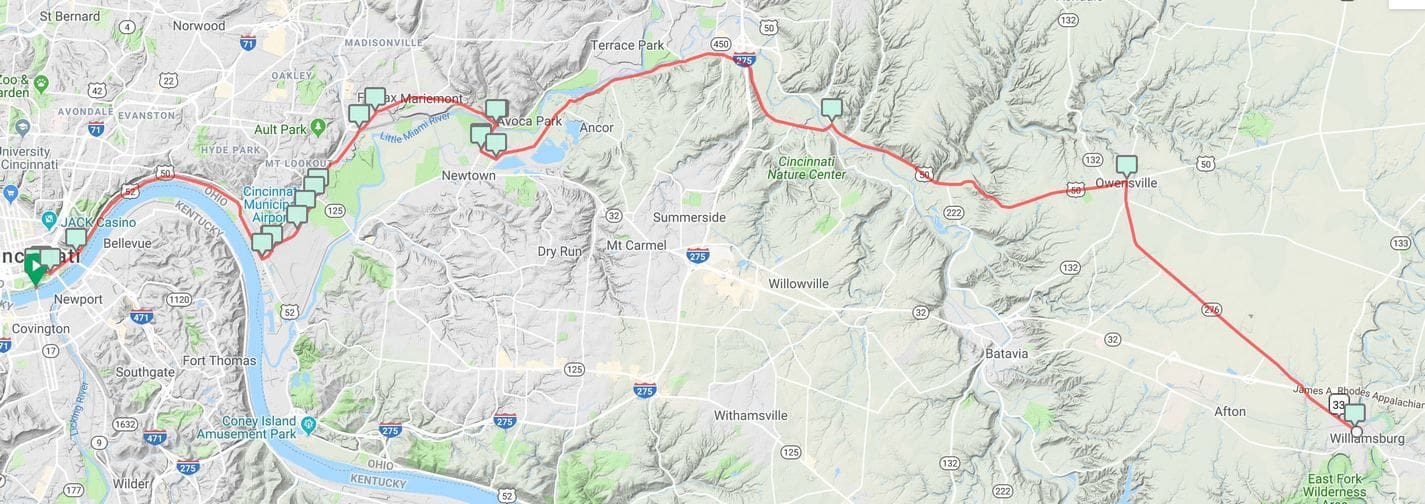
Here's a test of Google, BRouter, and Strava Route Builder.
For a test, I picked the Cincinnati Ohio riverfront to Williamsburg Ohio, since there's some busy main roads on the way that should be avoided. I just clicked the starting and ending points and let the app pick the route. (Of course, any of these allow the route to be dragged over to different roads.)
Google Bicycling Map
33.5 miles
Not the best route. It's okay for the first half, then it routes on US50 to Owensville. Riders avoid that if possible, it's very busy.
It did avoid RT 32, which is a multi-lane, very busy road -- that's the shortest route, but would be miserable on a bike.

BRouter
58.9 km (36.6 miles)
This is better. It took the bike trail to Milford. But then routed to US50--not a good choice at all. The rest of the route looks good.

Strava Route Builder
40.3 miles
This picks the most popular roads from uploaded Strava ride recordings.
It's hillier and longer than the other methods!
It climbs up the east side hill at mile 5 instead of going around the hill -- this climb is a more interesting route.
Takes the bike path to Milford, then follows "the usual" roads that most cyclists take to go SE from there.
Finally, it routes on quiet roads to East Fork Park -- a hillier route, but quiet and scenic.
This strava route is way different than the other routes. Many of these roads wouldn't be picked by a computer without knowing their popularity.
Strava Route Builder will often have a lot of turns -- which would be annoying to ride with just a cue sheet, but no problem with a GPS device.

Strava Route Builder -- minimize hills option
40.0 miles
This "minimize hills" route skips the climb at mile 5, and skips the bike trail, following the river road instead.
A reasonable route. I'd ride the standard route above, unless I wanted to get there faster and avoid climbing.

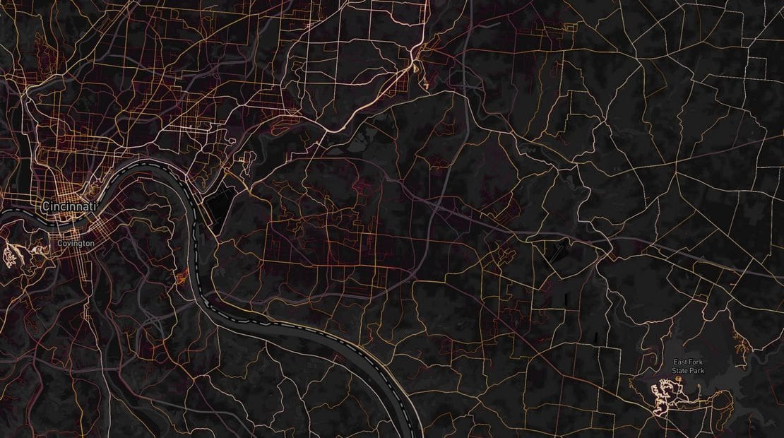
The Strava Heat Map that the routing is based on. This area map link.
White hot is the most popular, dim red the least popular.
~~~~~~~~~~~~~~~~~~~~~~~~~~~~~~~~~~~~~~~~~~~~~~~~~
ridewithgps
I never make a ridewithgps route by just clicking the end points. It only finds the most direct route that avoids limited access highways.
Instead, I'm zooming in, checking the route as I go, and often trying alternatives as I plot the route.
Here's the route it picked -- essentially the same as Google Map's route.
Google Maps with the Bicycling setting picks a direct route, which often is the worst option for cycling. I only use it for a quick estimate of distance between two points.
This Bicycling map is very useful for locating bike trails -- they show in green -- zoom way in, and the name of the trail is repeated down the green line.
The route it made doesn't show any hills or other info, either. It's not very useful.
~~~~~~~
Here's a test of Google, BRouter, and Strava Route Builder.
For a test, I picked the Cincinnati Ohio riverfront to Williamsburg Ohio, since there's some busy main roads on the way that should be avoided. I just clicked the starting and ending points and let the app pick the route. (Of course, any of these allow the route to be dragged over to different roads.)
Google Bicycling Map
33.5 miles
Not the best route. It's okay for the first half, then it routes on US50 to Owensville. Riders avoid that if possible, it's very busy.
It did avoid RT 32, which is a multi-lane, very busy road -- that's the shortest route, but would be miserable on a bike.
BRouter
58.9 km (36.6 miles)
This is better. It took the bike trail to Milford. But then routed to US50--not a good choice at all. The rest of the route looks good.
Strava Route Builder
40.3 miles
This picks the most popular roads from uploaded Strava ride recordings.
It's hillier and longer than the other methods!
It climbs up the east side hill at mile 5 instead of going around the hill -- this climb is a more interesting route.
Takes the bike path to Milford, then follows "the usual" roads that most cyclists take to go SE from there.
Finally, it routes on quiet roads to East Fork Park -- a hillier route, but quiet and scenic.
This strava route is way different than the other routes. Many of these roads wouldn't be picked by a computer without knowing their popularity.
Strava Route Builder will often have a lot of turns -- which would be annoying to ride with just a cue sheet, but no problem with a GPS device.
Strava Route Builder -- minimize hills option
40.0 miles
This "minimize hills" route skips the climb at mile 5, and skips the bike trail, following the river road instead.
A reasonable route. I'd ride the standard route above, unless I wanted to get there faster and avoid climbing.
The Strava Heat Map that the routing is based on. This area map link.
White hot is the most popular, dim red the least popular.
~~~~~~~~~~~~~~~~~~~~~~~~~~~~~~~~~~~~~~~~~~~~~~~~~
ridewithgps
I never make a ridewithgps route by just clicking the end points. It only finds the most direct route that avoids limited access highways.
Instead, I'm zooming in, checking the route as I go, and often trying alternatives as I plot the route.
Here's the route it picked -- essentially the same as Google Map's route.
Last edited by rm -rf; 11-02-18 at 06:14 AM.
11-02-18, 06:44 AM
#22
Senior Member
Join Date: Oct 2012
Location: Twin Cities, Minnesota, USA
Posts: 1,257
Bikes: 2017 Salsa Carbon Mukluk frame built with XT, 2018 Kona Rove NRB build with Sram Apex 1,2008 Salsa El Mariachi, 1986 Centurion Ironman
Mentioned: 11 Post(s)
Tagged: 0 Thread(s)
Quoted: 286 Post(s)
Liked 100 Times
in
65 Posts
Google Bicycling routing
Google Maps with the Bicycling setting picks a direct route, which often is the worst option for cycling. I only use it for a quick estimate of distance between two points.
This Bicycling map is very useful for locating bike trails -- they show in green -- zoom way in, and the name of the trail is repeated down the green line.
The route it made doesn't show any hills or other info, either. It's not very useful.
~~~~~~~
Here's a test of Google, BRouter, and Strava Route Builder.
For a test, I picked the Cincinnati Ohio riverfront to Williamsburg Ohio, since there's some busy main roads on the way that should be avoided. I just clicked the starting and ending points and let the app pick the route. (Of course, any of these allow the route to be dragged over to different roads.)
Google Bicycling Map
33.5 miles
Not the best route. It's okay for the first half, then it routes on US50 to Owensville. Riders avoid that if possible, it's very busy.
It did avoid RT 32, which is a multi-lane, very busy road -- that's the shortest route, but would be miserable on a bike.
BRouter
58.9 km (36.6 miles)
This is better. It took the bike trail to Milford. But then routed to US50--not a good choice at all. The rest of the route looks good.
Strava Route Builder
40.3 miles
This picks the most popular roads from uploaded Strava ride recordings.
It's hillier and longer than the other methods!
It climbs up the east side hill at mile 5 instead of going around the hill -- this climb is a more interesting route.
Takes the bike path to Milford, then follows "the usual" roads that most cyclists take to go SE from there.
Finally, it routes on quiet roads to East Fork Park -- a hillier route, but quiet and scenic.
This strava route is way different than the other routes. Many of these roads wouldn't be picked by a computer without knowing their popularity.
Strava Route Builder will often have a lot of turns -- which would be annoying to ride with just a cue sheet, but no problem with a GPS device.
Strava Route Builder -- minimize hills option
40.0 miles
This "minimize hills" route skips the climb at mile 5, and skips the bike trail, following the river road instead.
A reasonable route. I'd ride the standard route above, unless I wanted to get there faster and avoid climbing.
The Strava Heat Map that the routing is based on. This area map link.
White hot is the most popular, dim red the least popular.
~~~~~~~~~~~~~~~~~~~~~~~~~~~~~~~~~~~~~~~~~~~~~~~~~
ridewithgps
I never make a ridewithgps route by just clicking the end points. It only finds the most direct route that avoids limited access highways.
Instead, I'm zooming in, checking the route as I go, and often trying alternatives as I plot the route.
Here's the route it picked -- essentially the same as Google Map's route.
11-03-18, 06:53 AM
#23
Full Member
Not an app, but a website https://cycle.travel/map started in the UK and is expanding around the world.
It uses OSM maps, and is very simple to use. You can save your routes online, download them in a variety of formats, use Google streetview (where appropriate) to see specific points and it will show accommodation of different types if required.
It's very useful.
It uses OSM maps, and is very simple to use. You can save your routes online, download them in a variety of formats, use Google streetview (where appropriate) to see specific points and it will show accommodation of different types if required.
It's very useful.
11-03-18, 12:04 PM
#24
Senior Member
Join Date: Oct 2012
Location: Twin Cities, Minnesota, USA
Posts: 1,257
Bikes: 2017 Salsa Carbon Mukluk frame built with XT, 2018 Kona Rove NRB build with Sram Apex 1,2008 Salsa El Mariachi, 1986 Centurion Ironman
Mentioned: 11 Post(s)
Tagged: 0 Thread(s)
Quoted: 286 Post(s)
Liked 100 Times
in
65 Posts
I like it
Not an app, but a website https://cycle.travel/map started in the UK and is expanding around the world.
It uses OSM maps, and is very simple to use. You can save your routes online, download them in a variety of formats, use Google streetview (where appropriate) to see specific points and it will show accommodation of different types if required.
It's very useful.
It uses OSM maps, and is very simple to use. You can save your routes online, download them in a variety of formats, use Google streetview (where appropriate) to see specific points and it will show accommodation of different types if required.
It's very useful.
