


Advice Needed For The Katy Trail!
 02-22-19, 04:51 PM
#1

Let's do a Century
Thread Starter

Join Date: Oct 2004
Location: North Carolina
Posts: 8,316
Bikes: Cervelo R3 Disc, Pinarello Prince/Campy SR; Cervelo R3/Sram Red; Trek 5900/Duraace, Lynskey GR260 Ultegra
Mentioned: 59 Post(s)
Tagged: 0 Thread(s)
Quoted: 651 Post(s)
Liked 879 Times
in
408 Posts
Advice Needed For The Katy Trail!
I’m considering riding the full length of the Katy Trail this August. I’m driving out to Oregon to do Cycle Oregon September 7-14 and can bring both a road bike and a gravel bike.
I’m thinking of riding the Katy Trail on the way out. My fabulous wife is willing to SAG although she might have to brush up on her skills from my cross country ride!
It looks like Katy is 237 miles long. How much elevation change is on the Trail? Is it fairly easy riding? Are lodging and food spots fairly close to the Trail?
I’m okay with 5 hours a day on the bike or maybe more. I’ll have support so there aren’t any issues with logistics like food or lodging.
Any thought on doing the trail in 3 days vs 4 days or more?
Another suggestion she’s made is to take a separate trip in July and ride Katy plus the Mickelson Trail in South Dakota. Or I guess GAP is another option ?? Being retired is so nice....
Anyone have any thoughts on the Katy Trail?
 02-22-19, 05:12 PM
#2
Senior Member

Join Date: Nov 2014
Location: Eugene, Oregon, USA
Posts: 27,547
Mentioned: 217 Post(s)
Tagged: 0 Thread(s)
Quoted: 18376 Post(s)
Liked 4,511 Times
in
3,353 Posts
I only did the trail between St. Charles and Defiance/Augusta/Marthasville. Plus a small stretch around Columbia. 5+ years ago.
There was often wind out in the flats near Augusta/Marthasville, but I can't remember which direction.
The trail is fine crushed limestone, and when I did it, reasonably well groomed.
I always rode it on my old Colnago Super with 23mm tires, I think. I could definitely feel the extra rolling resistance attributed to the gravel, but never felt that I wanted any other bicycle for it.
If you are into wine, there are a number of wineries along the trail (which should be accessible by both road and bike).
02-22-19, 07:15 PM
#3

Senior Member

Join Date: Feb 2004
Location: St Peters, Missouri
Posts: 30,225
Bikes: Catrike 559 I own some others but they don't get ridden very much.
Mentioned: 16 Post(s)
Tagged: 0 Thread(s)
Quoted: 1572 Post(s)
Liked 643 Times
in
364 Posts
I live 2 miles from the Katy (near St Charles) so I ride it quite a lot.
The trail itself has very little elevation change but there are some steep but short hills whenever you leave the trail. The trail surface is crushed limestone. In the summertime it packs to become the next thing to blacktop in the high traffic areas but it can get noticeable more gravely in the more rural areas. I know people who have ridden it on just about any kind of bike you can mention. If you have a gravel bike, that's what I'd use but I wouldn't hesitate riding the whole length on a road bike either.
the trail road bed was originally designed for steam trains. They had to stop every 7 ors 8 miles for water so, although many of the train stop towns are gone, there are still lots of places to eat sleep or camp along the way.
May grandson's high school cross country team rides the length of the trail every year in 3 days. I used to know a fellow who wanted to ride the whole thing in one day but he had too much trouble planning for his support crew.
__________________
My greatest fear is all of my kids standing around my coffin and talking about "how sensible" dad was.
My greatest fear is all of my kids standing around my coffin and talking about "how sensible" dad was.
02-22-19, 09:47 PM
#4
Life Feeds On Life

Join Date: Jan 2018
Location: Hondo,Texas
Posts: 2,143
Bikes: Too many Motobecanes
Mentioned: 11 Post(s)
Tagged: 0 Thread(s)
Quoted: 4423 Post(s)
Liked 4,527 Times
in
3,029 Posts
Consider starting on The Rock Island Line at Pleasant Hill Mo that trail connects to The Katy. My first Katy ride I did in 3 days starting in Clinton and that was too quick. The next year I started on The Rock Island Line and took 5 days that was more enjoyable I actually took more breaks to look at stuff. I rode Eastward to St. Charles. If I go again this year in June I will start in St. Charles and ride westward for a difference.
02-23-19, 06:33 AM
#5
Have bike, will travel

Join Date: Feb 2006
Location: Lake Geneva, WI
Posts: 12,284
Bikes: Ridley Helium SLX, Canyon Endurance SL, De Rosa Professional, Eddy Merckx Corsa Extra, Schwinn Paramount (1 painted, 1 chrome), Peugeot PX10, Serotta Nova X, Simoncini Cyclocross Special, Raleigh Roker, Pedal Force CG2 and CX2
Mentioned: 46 Post(s)
Tagged: 0 Thread(s)
Quoted: 910 Post(s)
Liked 288 Times
in
158 Posts
The KATY is a great resource, however it can get a bit monotonous. Most of the time it's a straight, flat trail under a thick canopy of trees. Views of the river valley are obstructed for most of the trail. I enjoyed it as an alternative to pavement, particularly on hot summer days, but it's not very engaging.
I'd recommend one of the many gravel events in Missouri as an alternative. The Epic is, well, epic: https://epic150.com
It's 142 miles (and 11,000 ft of climbing) of killer gravel in the scenic Lake of the Woods region. See: https://www.strava.com/routes/12754747
Many participants consider it to be more demanding than the Dirty Kansa 200.
The Cuba Gravel Crisis is another scenic ride that is my favorite. It's less extreme than the Epic and the weather in the fall is usually ideal.
Last edited by Barrettscv; 02-23-19 at 07:36 AM.
02-23-19, 04:09 PM
#6
Old fart

Join Date: Nov 2004
Location: Appleton WI
Posts: 24,786
Bikes: Several, mostly not name brands.
Mentioned: 153 Post(s)
Tagged: 0 Thread(s)
Quoted: 3588 Post(s)
Liked 3,400 Times
in
1,934 Posts
I've only ridden part of the Katy Trail, but it's built on old railroad right of way, so the inclines are limited to about 2° maximum. Crushed limestone surface works best with 28mm or wider tires. Shouldn't be too grueling unless you have a persistent headwind.
02-23-19, 04:21 PM
#7
Senior Member
Join Date: Nov 2014
Location: Eugene, Oregon, USA
Posts: 27,547
Mentioned: 217 Post(s)
Tagged: 0 Thread(s)
Quoted: 18376 Post(s)
Liked 4,511 Times
in
3,353 Posts
Which turned out to be about 5 feet tall.
 02-23-19, 08:01 PM
#8
Palmer

Join Date: Mar 2007
Location: Parts Unknown
Posts: 8,625
Bikes: Mike Melton custom, Alex Moulton AM, Dahon Curl
Mentioned: 37 Post(s)
Tagged: 0 Thread(s)
Quoted: 1668 Post(s)
Liked 1,821 Times
in
1,059 Posts
We rode the Mickelson from Hill City to Deadwood. Highly recommended rail-trail ride. Tunnels, trestles, mountains, streams. Well groomed crushed granite surface, long, easy grades. Locals friendly, polite, kept saying, 'you should be here when the Aspens turn' so maybe on the way back from Cycle Oregon?
02-24-19, 09:18 AM
#9
Let's do a Century
Thread Starter
Join Date: Oct 2004
Location: North Carolina
Posts: 8,316
Bikes: Cervelo R3 Disc, Pinarello Prince/Campy SR; Cervelo R3/Sram Red; Trek 5900/Duraace, Lynskey GR260 Ultegra
Mentioned: 59 Post(s)
Tagged: 0 Thread(s)
Quoted: 651 Post(s)
Liked 879 Times
in
408 Posts
We rode the Mickelson from Hill City to Deadwood. Highly recommended rail-trail ride. Tunnels, trestles, mountains, streams. Well groomed crushed granite surface, long, easy grades. Locals friendly, polite, kept saying, 'you should be here when the Aspens turn' so maybe on the way back from Cycle Oregon?
__________________
Ride your Ride!!
Ride your Ride!!
02-24-19, 08:38 PM
#10
Senior Member

Join Date: Jul 2003
Location: Cincinnati, Ohio
Posts: 903
Bikes: 2018 Breezer Greenway, 2011 Raleigh International, 3 - '73 World Voyageurs, Trek 700
Mentioned: 0 Post(s)
Tagged: 0 Thread(s)
Quoted: 1 Post(s)
Likes: 0
Liked 0 Times
in
0 Posts
I've ridden the trail a couple of times and we had a lot of fun. One year the temperature was over 100 degrees every day which made it tough to make good time. We stayed at bed and breakfasts and really had fun with those.
__________________
2018 Breezer Greenway
2011 Raleigh International
'73 World Voyageurs -
Proud owner of all three colors made! Orange, Blue , Yellow .
2018 Breezer Greenway
2011 Raleigh International
'73 World Voyageurs -
Proud owner of all three colors made! Orange, Blue , Yellow .
02-24-19, 09:45 PM
#11
Life Feeds On Life
Join Date: Jan 2018
Location: Hondo,Texas
Posts: 2,143
Bikes: Too many Motobecanes
Mentioned: 11 Post(s)
Tagged: 0 Thread(s)
Quoted: 4423 Post(s)
Liked 4,527 Times
in
3,029 Posts
The Mickelson Trail is awesome as other posters have stated. Cruised the trail late July in 2017 and 2018 just in time to beat the motorcycle rally. Nothing against the motorcycles just every place to stay will be booked. Most people were on mountain bikes in 2017 I rode my cyclocross bike in 2018 I took my MTB both worked well.
02-25-19, 07:33 AM
#12
Palmer
Join Date: Mar 2007
Location: Parts Unknown
Posts: 8,625
Bikes: Mike Melton custom, Alex Moulton AM, Dahon Curl
Mentioned: 37 Post(s)
Tagged: 0 Thread(s)
Quoted: 1668 Post(s)
Liked 1,821 Times
in
1,059 Posts
02-27-19, 07:37 PM
#13
Senior Member

I've ridden the Katy Trail end-to-end 8 times so far. If you were thinking about doing the ride in June, I'd suggest the Katy Trail Ride (https://mostateparks.com/2019ktride). Signups start March 1st and sometimes fills up quickly.
1. Take the gravel bike. I've ridden it on a hybrid, touring bike, and road bike (for a short distance). Both the hybird and touring bikes had 700x32 tires which were adequate. However I just bought a grave bike with 650x47 tires and looking forward to the nicer ride.
2. The first 160 miles or so is flat as can be. Out of Boonville it gets somewhat hilly but only rails-to-trail hilly with only a couple of places near 5% grade. Going from east-to-west the wind can be a problem.
3. I've always taken 5 days and it's a pretty relaxing ride at that rate. I'd recommend staying at Boonville and Sedalia even though that makes for somewhat short 35 mile days but that's in the 'hilly' area.
4. Here's an excellent resource for both the Katy and Rock Island trails. Lots of info about lodging, food, etc. The forum has a lot of updated info of what's open and closed. https://bikekatytrail.com/default.aspx
5. Speaking of open and closed, a lot of places on the trail aren't open on Mondays and Tuesdays. You might want to start your adventure on Wednesday.
6. It can be HOT in August in Missouri so bring plenty of liquids. Usually there's a trail-head about every 15 miles but not all of them have fluids.
Obviously I like the Katy Trail, but so does about everyone else that I've talked to who have ridden it.
02-28-19, 09:45 AM
#14
Senior Member
Join Date: Jan 2010
Posts: 39,238
Mentioned: 211 Post(s)
Tagged: 1 Thread(s)
Quoted: 18415 Post(s)
Liked 15,545 Times
in
7,329 Posts
The other "issue" with the trail is that a lot of it is isolated, meaning your SAG cannot be able to reach you at some points if there is a problem. And towns are infrequent. IIRC, there is nothing between Lead and Rochford, where you will find a bar/restaurant which likely isn't open on Sunday. South from there you won't find anything until Hill City, which has plenty of services. Hill City to Custer has nothing, but it's a short haul with relatively easy access to the highway. Custer has all the touristy services. South of Custer there are no towns until Pringle, which has a bar/restaurant. After that, there is nothing along the trail until the end in Edgemont, where there is a motel and some restaurants and lot and lots of bunnies. (Don't ask me why, but they were all over town.) The cool thing is that there are shelters, bathrooms and water cisterns well spaced along the trail. The locations are shown on the official map. They really got it right.
With all that said, it's a great ride. My favorite section was between Englewood and Hill City. That's where the tunnels are. Hill City to Custer goes right past Crazy Horse. You can see it from the trail. South of Custer has some pretty views of the surrounding area. This album has photos from the trail. You can tell which ones they are. The first one is the one of the gate:
https://www.flickr.com/photos/105349603@N05/albums/72157655263744881
About those gates: There are a lot of them. You have to stop, open the gate and make sure it closes properly behind you. Adds time to the day. So do the many, many bridges. The transition between trail surface and bridge surface was usually not smooth, requiring slowing. In short, budget extra time. Finally, note that you are at elevation in places. Bring foul weather gear in case a storm pops up. During my trip I was hanging out in Hill City one day when two people came into town from the north. They had gotten caught in large thunder storm up on the hill north of town. Matters were made worse by free range cattle that forced them to stop for a while. The husband was not properly prepared for the conditions. His fingers were literally blue from cold. This was in late June, mind you. The first night on the trail, while I was camping in Hill City, I got hit with a thunderstorm with hail. That stone pictured was the size of a golf ball. I think the fact that my tent was under a tree is what saved the fly from being breached.
Last edited by indyfabz; 02-28-19 at 09:52 AM.
02-28-19, 10:07 AM
#15
Senior Member
Join Date: Feb 2004
Location: St Peters, Missouri
Posts: 30,225
Bikes: Catrike 559 I own some others but they don't get ridden very much.
Mentioned: 16 Post(s)
Tagged: 0 Thread(s)
Quoted: 1572 Post(s)
Liked 643 Times
in
364 Posts
I've ridden the Katy Trail end-to-end 8 times so far. If you were thinking about doing the ride in June, I'd suggest the Katy Trail Ride (https://mostateparks.com/2019ktride). Signups start March 1st and sometimes fills up quickly.
1. Take the gravel bike. I've ridden it on a hybrid, touring bike, and road bike (for a short distance). Both the hybird and touring bikes had 700x32 tires which were adequate. However I just bought a grave bike with 650x47 tires and looking forward to the nicer ride.
2. The first 160 miles or so is flat as can be. Out of Boonville it gets somewhat hilly but only rails-to-trail hilly with only a couple of places near 5% grade. Going from east-to-west the wind can be a problem.
3. I've always taken 5 days and it's a pretty relaxing ride at that rate. I'd recommend staying at Boonville and Sedalia even though that makes for somewhat short 35 mile days but that's in the 'hilly' area.
4. Here's an excellent resource for both the Katy and Rock Island trails. Lots of info about lodging, food, etc. The forum has a lot of updated info of what's open and closed. https://bikekatytrail.com/default.aspx
5. Speaking of open and closed, a lot of places on the trail aren't open on Mondays and Tuesdays. You might want to start your adventure on Wednesday.
6. It can be HOT in August in Missouri so bring plenty of liquids. Usually there's a trail-head about every 15 miles but not all of them have fluids.
Obviously I like the Katy Trail, but so does about everyone else that I've talked to who have ridden it.
1. Take the gravel bike. I've ridden it on a hybrid, touring bike, and road bike (for a short distance). Both the hybird and touring bikes had 700x32 tires which were adequate. However I just bought a grave bike with 650x47 tires and looking forward to the nicer ride.
2. The first 160 miles or so is flat as can be. Out of Boonville it gets somewhat hilly but only rails-to-trail hilly with only a couple of places near 5% grade. Going from east-to-west the wind can be a problem.
3. I've always taken 5 days and it's a pretty relaxing ride at that rate. I'd recommend staying at Boonville and Sedalia even though that makes for somewhat short 35 mile days but that's in the 'hilly' area.
4. Here's an excellent resource for both the Katy and Rock Island trails. Lots of info about lodging, food, etc. The forum has a lot of updated info of what's open and closed. https://bikekatytrail.com/default.aspx
5. Speaking of open and closed, a lot of places on the trail aren't open on Mondays and Tuesdays. You might want to start your adventure on Wednesday.
6. It can be HOT in August in Missouri so bring plenty of liquids. Usually there's a trail-head about every 15 miles but not all of them have fluids.
Obviously I like the Katy Trail, but so does about everyone else that I've talked to who have ridden it.
That looks like about a $1200 tour to me. I don't camp anymore. I've got a couple of weeks to convince my wife it's a good idea. Do you go all the way to Machens or bail out at St Charles?
__________________
My greatest fear is all of my kids standing around my coffin and talking about "how sensible" dad was.
My greatest fear is all of my kids standing around my coffin and talking about "how sensible" dad was.
02-28-19, 11:59 AM
#16
Support JDRF
Join Date: May 2007
Location: Arkansas
Posts: 925
Bikes: Specialized Sirrus, Specialized Roubaix Elite
Mentioned: 0 Post(s)
Tagged: 0 Thread(s)
Quoted: 52 Post(s)
Likes: 0
Liked 3 Times
in
2 Posts
There really isn't anything in Machens. Unless you just want bragging rights for completing all of it I would stop at St. Charles. Double check the places you want to stay, the maps show some towns that appear to have supplies and they really don't. I would suggest the gravel bike. I did it on a hybrid with tires as wide as I could fit in the forks. It worked out ok, but the trail can get soft after a rain. The trail is mostly flat except after Sedalia. Nothing bad just some up and downs for a while. Most is in the shade but make sure you have plenty of water with you. The non shady spots that time of the year will be really hot.
02-28-19, 07:43 PM
#17
Senior Member
The official tour ends at St. Charles. When the ride starts in St. Charles I get there the day before and ride to Machens to say that I did the whole ride. This year we start in Clinton so I'll probably head over your direction and ride to Machens sometime in May to test out my new gravel bike.
I use the tent service as it's cheaper than the hotels, but much more convenient than setting up / breaking down your own tent daily. The tent service comes with an air mattress, snacks, chairs, and drinks. Of course it can still be hot or stormy compared to a nice hotel room.
Signup starts on March 1st and sometimes fills up quickly.
Jerry
Last edited by JerrySTL; 02-28-19 at 07:46 PM.
03-01-19, 10:38 AM
#18
Senior Member
Join Date: Feb 2004
Location: St Peters, Missouri
Posts: 30,225
Bikes: Catrike 559 I own some others but they don't get ridden very much.
Mentioned: 16 Post(s)
Tagged: 0 Thread(s)
Quoted: 1572 Post(s)
Liked 643 Times
in
364 Posts
Won't be this year.
I have a grand daughter in Seattle graduating high school near that time. Maybe next year. I'm interested in the camp outfitter option.
I have a grand daughter in Seattle graduating high school near that time. Maybe next year. I'm interested in the camp outfitter option.
__________________
My greatest fear is all of my kids standing around my coffin and talking about "how sensible" dad was.
My greatest fear is all of my kids standing around my coffin and talking about "how sensible" dad was.
03-01-19, 02:11 PM
#19
Let's do a Century
Thread Starter
Join Date: Oct 2004
Location: North Carolina
Posts: 8,316
Bikes: Cervelo R3 Disc, Pinarello Prince/Campy SR; Cervelo R3/Sram Red; Trek 5900/Duraace, Lynskey GR260 Ultegra
Mentioned: 59 Post(s)
Tagged: 0 Thread(s)
Quoted: 651 Post(s)
Liked 879 Times
in
408 Posts
I did most the Mickelson (Englewood Trailhead to the southern terminus in Edgemont) during my Black Hills Tour. Take a look at the official SD state park's web site. The trail is not flat. Grades of western rail lines are generally steeper than those of the Midwest. The "climb" south from Englewood is several miles. IIRC, it averages around 3%. According to the official site, the hardest uphill section is south from Deadwood. Between Mystic and Hill City there is another uphill section that you will feel.
The other "issue" with the trail is that a lot of it is isolated, meaning your SAG cannot be able to reach you at some points if there is a problem. And towns are infrequent. IIRC, there is nothing between Lead and Rochford, where you will find a bar/restaurant which likely isn't open on Sunday. South from there you won't find anything until Hill City, which has plenty of services. Hill City to Custer has nothing, but it's a short haul with relatively easy access to the highway. Custer has all the touristy services. South of Custer there are no towns until Pringle, which has a bar/restaurant. After that, there is nothing along the trail until the end in Edgemont, where there is a motel and some restaurants and lot and lots of bunnies. (Don't ask me why, but they were all over town.) The cool thing is that there are shelters, bathrooms and water cisterns well spaced along the trail. The locations are shown on the official map. They really got it right.
With all that said, it's a great ride. My favorite section was between Englewood and Hill City. That's where the tunnels are. Hill City to Custer goes right past Crazy Horse. You can see it from the trail. South of Custer has some pretty views of the surrounding area. This album has photos from the trail. You can tell which ones they are. The first one is the one of the gate:
https://www.flickr.com/photos/105349603@N05/albums/72157655263744881
About those gates: There are a lot of them. You have to stop, open the gate and make sure it closes properly behind you. Adds time to the day. So do the many, many bridges. The transition between trail surface and bridge surface was usually not smooth, requiring slowing. In short, budget extra time. Finally, note that you are at elevation in places. Bring foul weather gear in case a storm pops up. During my trip I was hanging out in Hill City one day when two people came into town from the north. They had gotten caught in large thunder storm up on the hill north of town. Matters were made worse by free range cattle that forced them to stop for a while. The husband was not properly prepared for the conditions. His fingers were literally blue from cold. This was in late June, mind you. The first night on the trail, while I was camping in Hill City, I got hit with a thunderstorm with hail. That stone pictured was the size of a golf ball. I think the fact that my tent was under a tree is what saved the fly from being breached.
I've ridden the paved roads near there on Tour de Wyoming a few years ago and it was a blast, except for cracking the rear rim on my bike.
I could not get your links on Flikr to work for the photos.......
__________________
Ride your Ride!!
Ride your Ride!!
03-01-19, 02:41 PM
#20
Senior Member
Join Date: Jan 2010
Posts: 39,238
Mentioned: 211 Post(s)
Tagged: 1 Thread(s)
Quoted: 18415 Post(s)
Liked 15,545 Times
in
7,329 Posts
As always thank you for your insights. When I looked at the elevation charts it seemed like riding from Deadwood to Edgemont might be more downhill than riding in the reverse direction. I don't know if that's the case but if I rode it that would be the direction I'd plan to go. That is a long one day ride on the gravel bike so maybe I need to think about doing it in two days. Especially since I'll be heading out to Oregon for a week's plus riding right after that.
The hotel in Edgemont is pretty basic and not large. Might want to make a reservation a day ahead if you plan to stay there. There not much in that immediate area. You don't want to camp at the muni campground at the south end of town. Edgemont is a crew change point on the busy BNSF Powder River Subdivision. At the height of traffic there was at least one coal train every 30 min. Other trains as well. And there are two crossings in town where they blow the horns. Makes for a lot of noise.
03-01-19, 04:06 PM
#21
Life Feeds On Life
Join Date: Jan 2018
Location: Hondo,Texas
Posts: 2,143
Bikes: Too many Motobecanes
Mentioned: 11 Post(s)
Tagged: 0 Thread(s)
Quoted: 4423 Post(s)
Liked 4,527 Times
in
3,029 Posts
One big climb out of Deadwood then mostly downhill except one long gradual climb around Crazy Horse. I ridden the trail both ways it was a lot more fun downhill  Custer to Edgemont is a nice cruise there is a pit stop about halfway but the smell and the flies I found a bush to go lol. Anyway it is a beautiful trail.
Custer to Edgemont is a nice cruise there is a pit stop about halfway but the smell and the flies I found a bush to go lol. Anyway it is a beautiful trail.
03-05-19, 02:58 PM
#22
Junior Member
Join Date: Aug 2009
Posts: 20
Mentioned: 0 Post(s)
Tagged: 0 Thread(s)
Quoted: 0 Post(s)
Likes: 0
Liked 0 Times
in
0 Posts
I'm a little late to this thread but if you are interested in the Katy, you might want to check out a blog I did of my 6 day trip in September of 2018. I started at the trailhead in Clinton and headed east... I really enjoyed my time on the trail and I think my blog will give you an idea of the terrain and the trail in general. It also includes a short video of each day... I'll be 60 this year and plan on doing the GAP/C&O as my next adventure.
https://www.jimbikesthekaty.com
Jim
https://www.jimbikesthekaty.com
Jim
03-14-19, 09:27 PM
#23
Life Feeds On Life
Join Date: Jan 2018
Location: Hondo,Texas
Posts: 2,143
Bikes: Too many Motobecanes
Mentioned: 11 Post(s)
Tagged: 0 Thread(s)
Quoted: 4423 Post(s)
Liked 4,527 Times
in
3,029 Posts
GAP and C&O is awesome. I lived in Pittsburgh in the early 1970s when I was very young but I can still remember the snow and the hills. You won’t be disappointed on this route.
03-23-19, 04:55 PM
#24
Senior Member

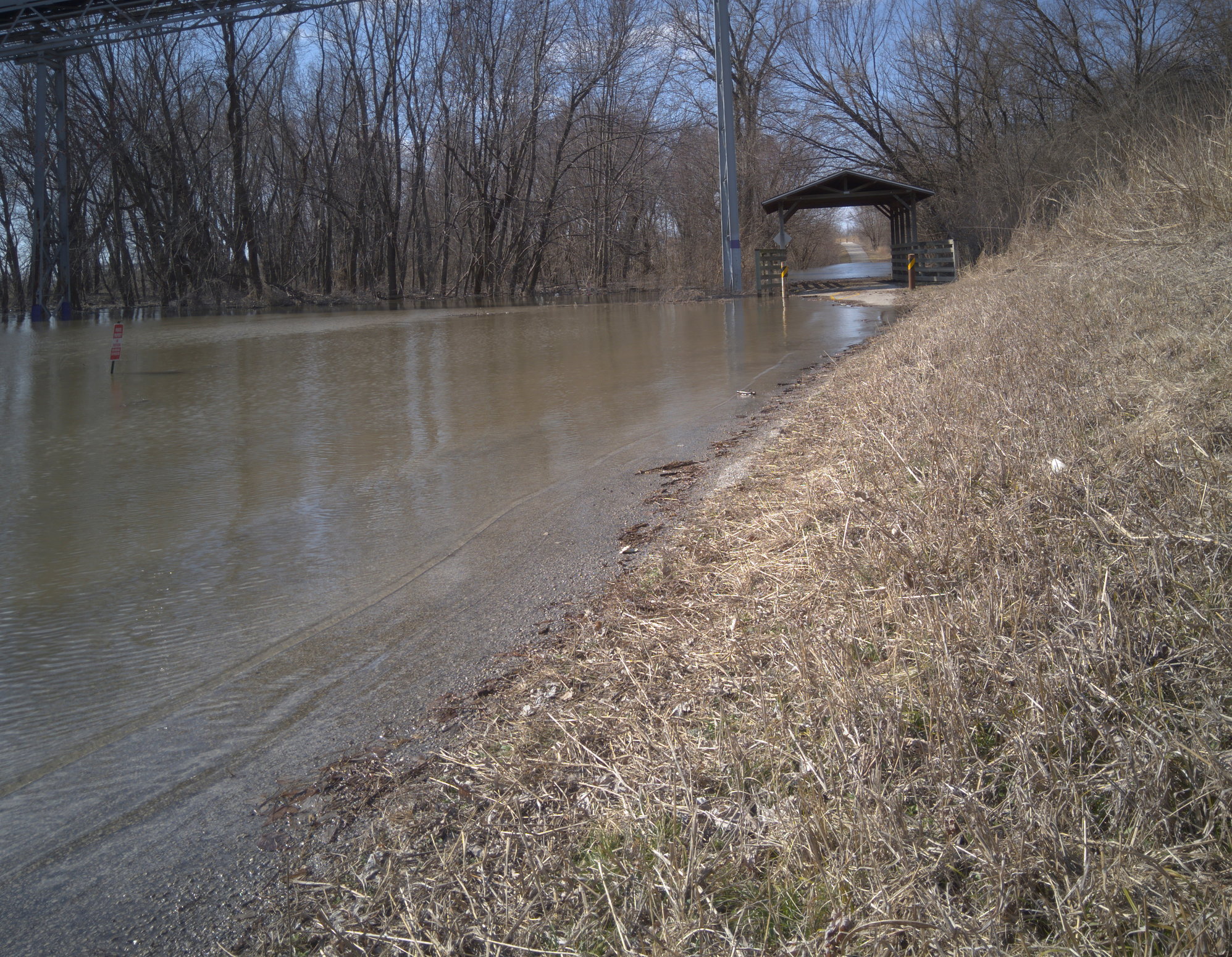
I think the C&O trail is having problems, or recently had problems, with severe washout conditions. I'm wondering if the Katy won't have similar problems this year, with the Missouri flooding... The part of the Confluence Trail near the Great Rivers Research Center is already a part of the Mississippi (count my s's and p's) River.
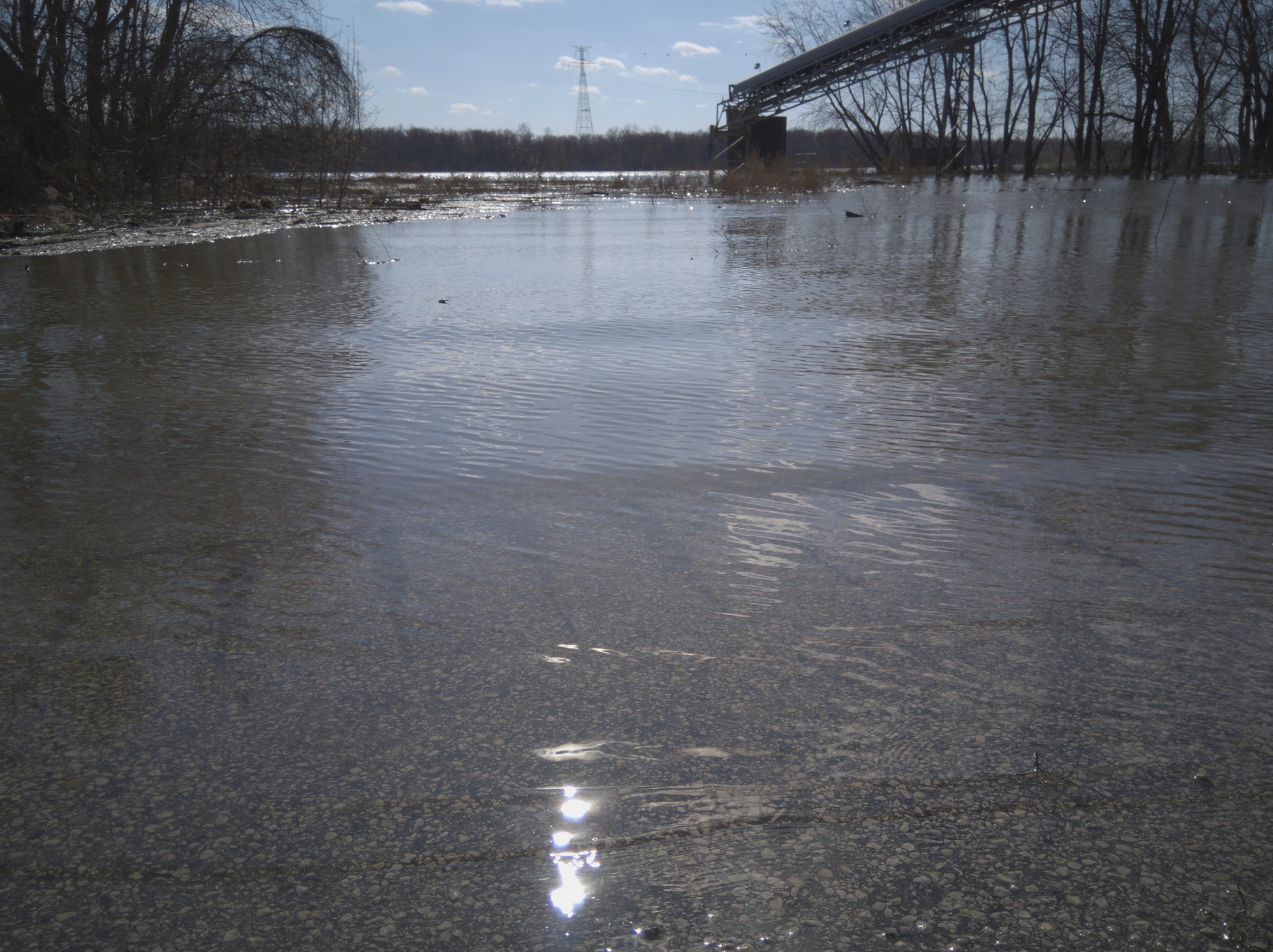
Confluence Trail, visible under a layer of Mississippi River
Another pic of the trail.
Confluence Trail, visible under a layer of Mississippi River
Another pic of the trail.
Last edited by David Bierbaum; 03-23-19 at 05:18 PM. Reason: additional thoughts. and some pics

