


Do you trust the stats...Map my ride?
 07-19-13, 06:32 PM
#1
Senior Member
Thread Starter
Join Date: Jul 2013
Posts: 167
Bikes: '13 Specialized Secteur Compact
Mentioned: 0 Post(s)
Tagged: 0 Thread(s)
Quoted: 0 Post(s)
Likes: 0
Liked 0 Times
in
0 Posts
Do you trust the stats...Map my ride?
Just wondering if you guys trust the stats for map my ride, like the elevation, and grade?
I know there are a bunch of programs out there, just wondering your opinions!
Thanks
I know there are a bunch of programs out there, just wondering your opinions!
Thanks
 07-19-13, 07:23 PM
#2

Senior Member

Join Date: Feb 2013
Location: Phoenix, AZ
Posts: 8,088
Mentioned: 10 Post(s)
Tagged: 0 Thread(s)
Quoted: 686 Post(s)
Likes: 0
Liked 5 Times
in
5 Posts
None of the apps, not even garmin's will be 100% accurate, but I think they all do pretty well.
I take the same route to work and the same route home every day...yet my mileage and elevation are always a little bit different from one another. I have a garmin 810. Same went for when I was using map my ride, strava, and wahoo fitness...they were all close, but none were exact.
From my experience, elevation/grade had bigger differences than distance though.
 07-19-13, 07:30 PM
#3
Senior Member
Thread Starter
Join Date: Jul 2013
Posts: 167
Bikes: '13 Specialized Secteur Compact
Mentioned: 0 Post(s)
Tagged: 0 Thread(s)
Quoted: 0 Post(s)
Likes: 0
Liked 0 Times
in
0 Posts
Okay. My bike computer doesn't do elevation and grade, just distance and time.
The main reason I ask is because im trying to get better at hills, and I look at these apps (after thinking "Nice, I showed that hard hill who's boss") only to have the app tell me they are a 6%average or something...
The main reason I ask is because im trying to get better at hills, and I look at these apps (after thinking "Nice, I showed that hard hill who's boss") only to have the app tell me they are a 6%average or something...
07-19-13, 07:51 PM
#4
Senior Member
Join Date: Feb 2013
Location: North Texas
Posts: 79
Bikes: Fuji Robaix, Specialized Stumpjumper
Mentioned: 0 Post(s)
Tagged: 0 Thread(s)
Quoted: 0 Post(s)
Likes: 0
Liked 0 Times
in
0 Posts
I use a cycling ap on my phone. Did not take long to figure out that the map function did not account for the hills. A measured route of 25 miles showed 23 miles on the distance register. Others with more expensive equipment have had similar experiences.
07-19-13, 08:19 PM
#5
In Real Life

Join Date: Jan 2003
Location: Down under down under
Posts: 52,152
Bikes: Lots
Mentioned: 141 Post(s)
Tagged: 0 Thread(s)
Quoted: 3203 Post(s)
Liked 596 Times
in
329 Posts
Okay. My bike computer doesn't do elevation and grade, just distance and time.
The main reason I ask is because im trying to get better at hills, and I look at these apps (after thinking "Nice, I showed that hard hill who's boss") only to have the app tell me they are a 6%average or something...
The main reason I ask is because im trying to get better at hills, and I look at these apps (after thinking "Nice, I showed that hard hill who's boss") only to have the app tell me they are a 6%average or something...
But "average" can be deceiving. The hill might start at 3% and do that for a while, then up to 5% for a bit, and then for the last 500 metres, maybe it will be 8%. And somehow these apps will average that to 6% but in reality most of your ride averaged at 4% with a steep pinch at the end.
__________________
Rowan
My fave photo threads on BF
Century A Month Facebook Group
Machka's Website
Photo Gallery
Rowan
My fave photo threads on BF
Century A Month Facebook Group
Machka's Website
Photo Gallery
07-19-13, 08:56 PM
#6
Senior Member
Join Date: Nov 2008
Location: Bay Area, Calif.
Posts: 7,239
Mentioned: 13 Post(s)
Tagged: 0 Thread(s)
Quoted: 659 Post(s)
Likes: 0
Liked 7 Times
in
6 Posts
Cumulative elevation gain is very difficult to get accurately, especially on fairly flat rides with lots of little ups and downs. Each little rise will have some measurement error associated with it and then when you add them all together the total error can be quite large. OTOH, a ride that just climbs all the way up a mountain and then comes back down will be measured much more accurately. Grade is also difficult to measure precisely. As Machka indicated, part of the problem is what distance you choose to measure over. If you average over a large distance the result will be more accurate but will only show the average grade over that long stretch and there may well be short sections that are much steeper. OTOH, measuring over a very short section can be misleading - both due to larger measurement errors and because that value doesn't really show how steep the whole climb is.
One thing I've noticed on programs that get the elevation data from topographic map data is that they don't take into account how the man-made structures have affected things. On many bridge crossings they show you rising gradually up to the start of the bridge, then falling off a cliff to get down to water level on the crossing itself, and then jumping back up another cliff on the other side. Similarly, when the road construction has leveled the land with cut-throughs of hills and fill-in of valleys the programs tend to overstate the elevation gains.
One thing I've noticed on programs that get the elevation data from topographic map data is that they don't take into account how the man-made structures have affected things. On many bridge crossings they show you rising gradually up to the start of the bridge, then falling off a cliff to get down to water level on the crossing itself, and then jumping back up another cliff on the other side. Similarly, when the road construction has leveled the land with cut-throughs of hills and fill-in of valleys the programs tend to overstate the elevation gains.
07-20-13, 10:18 AM
#7
Senior Member
Join Date: Feb 2013
Location: Phoenix, AZ
Posts: 8,088
Mentioned: 10 Post(s)
Tagged: 0 Thread(s)
Quoted: 686 Post(s)
Likes: 0
Liked 5 Times
in
5 Posts
I wouldn't let it bother you, you're still climbing and you're still getting faster. Look at the stats and keep them in the back of your head, but listen to your legs.
07-20-13, 03:12 PM
#8

don't try this at home.

Join Date: Jan 2006
Location: N. KY
Posts: 5,940
Mentioned: 10 Post(s)
Tagged: 0 Thread(s)
Quoted: 974 Post(s)
Liked 512 Times
in
352 Posts
My Garmin uses a barometer to measure elevation. GPS receivers can calculate elevation, but it takes some time to get enough measurements to be accurate. The barometer is fast. But a barometer is fooled by wind pressure and by weather changes in pressure.
Mapping software uses the known elevation points on the map to estimate the actual elevation along the road. It's often fooled by roads climbing up the side of steep slopes. Being off by just a few feet can change the grade calculations.
Most GPS software and most mapping sites count every little elevation change in the ride. That's OK as a comparison between rides.
But mapmyride has always rounded off small elevation gains. I think they ignore any climb under 10 meters (33 feet). So a rolling ride can show very little elevation on mapmyride. They always show a lot less elevation gain than other sites. I can see their reasons.
It seems that mapmyride averages climbs more if the ride is long. So a 60 mile ride might show a 3% hill, but that same hill on a shorter ride would show the actual steep 8% sections within the climb.
~~~~~~~~~~~~~~~~~~~~~~~~
My Garmin elevation gains are usually quite close the totals that ridewithgps calculates from the maps.
And when I ride up the Blue Ridge Parkway climbs, my Garmin is often within 10 feet of the posted elevation signs at the overlooks. So it's tracking the actual elevation pretty closely. But one day I stopped at a rest stop for a half hour when a cold front blew in. The Garmin's barometer elevation changed by 150 feet while sitting there.
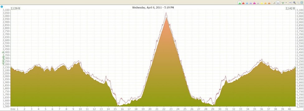
Here's an example ride. The mapping software calculated the thin line as the elevation for this route. It has lots of small jagged rises and dips. The solid green part is the Garmin elevation recording. The road is actually more like the Garmin, with smooth elevation changes.
Both the map and the Garmin readings are within 50 feet of elevation for almost every point in the ride. That's good. ( At mile 16, the mapping software thought the road went over a ridge at the bottom of the valley, but it cut through instead.)
Mapping software uses the known elevation points on the map to estimate the actual elevation along the road. It's often fooled by roads climbing up the side of steep slopes. Being off by just a few feet can change the grade calculations.
Most GPS software and most mapping sites count every little elevation change in the ride. That's OK as a comparison between rides.
But mapmyride has always rounded off small elevation gains. I think they ignore any climb under 10 meters (33 feet). So a rolling ride can show very little elevation on mapmyride. They always show a lot less elevation gain than other sites. I can see their reasons.
It seems that mapmyride averages climbs more if the ride is long. So a 60 mile ride might show a 3% hill, but that same hill on a shorter ride would show the actual steep 8% sections within the climb.
~~~~~~~~~~~~~~~~~~~~~~~~
My Garmin elevation gains are usually quite close the totals that ridewithgps calculates from the maps.
And when I ride up the Blue Ridge Parkway climbs, my Garmin is often within 10 feet of the posted elevation signs at the overlooks. So it's tracking the actual elevation pretty closely. But one day I stopped at a rest stop for a half hour when a cold front blew in. The Garmin's barometer elevation changed by 150 feet while sitting there.
Here's an example ride. The mapping software calculated the thin line as the elevation for this route. It has lots of small jagged rises and dips. The solid green part is the Garmin elevation recording. The road is actually more like the Garmin, with smooth elevation changes.
Both the map and the Garmin readings are within 50 feet of elevation for almost every point in the ride. That's good. ( At mile 16, the mapping software thought the road went over a ridge at the bottom of the valley, but it cut through instead.)
Last edited by rm -rf; 07-20-13 at 03:21 PM.

Thread
Thread Starter
Forum
Replies
Last Post
AllWeatherJeff
Long Distance Competition/Ultracycling, Randonneuring and Endurance Cycling
26
07-02-19 01:36 PM
sakau2007
General Cycling Discussion
10
08-10-15 08:19 PM
quadripper
Training & Nutrition
10
06-03-13 10:00 AM
