


Concerns about using a mounted phone while touring
 07-26-20, 06:01 AM
#1
Member
Thread Starter
Join Date: Apr 2011
Posts: 29
Mentioned: 0 Post(s)
Tagged: 0 Thread(s)
Quoted: 18 Post(s)
Liked 0 Times
in
0 Posts
Concerns about using a mounted phone while touring
Hi all,
In 2 months I will be leaving on a year long touring expedition. I will be entirely in the US and the trip will be about 14000 miles. I plan to use my phone mounted to the handlebars as my primary navigation tool. Though as i see it there are 4 concerns and would like your input.
1) Making phone water resistant. My plan as it stands now is if it starts raining while riding to use a ziplock bag combined with rubber bands. If its raining hard I won't be riding. Any other suggestions?
2) Reducing glare. I'm planning to get a glare resistant screen protector. Any other suggestions?
3) Overheating! This is a big one. I'm not talking about from phone usage but overheating as a result of prolonged direct exposure to sunlight. This in turn will activate a phone safety feature which shuts down phone until it has cooled. I currently have it in a white case. Though I really need help with this one. Any suggestions or ideas?
4) Phone service - According to MetroPCS coverage map I should have service approximately 80% of the trip. I'm planning on speaking with Metro about getting access to other carriers when not in a metro service area (parts of Arizona, Montana, etc...) Apparently for more money monthly this is an option. Any other suggestions?
Last, I should mention that buying all the maps I would need from Adventure Cycling is not an option. I may buy a few but to buy them all it would cost well over 500 dollars. Thanks in advance for your help.
 07-26-20, 06:29 AM
#2
Senior Member
in all seriousness, using a phone full time on a handlebar aint a good idea, for all the reasons you mentioned.
I do get wanting to use gps technology for some directional aiding, but honestly (and its not just cuz Im an old fart in my 50s) the vast majority of the time we dont need turn by turn directions. Sure, in urban settings it is a help, but the vast vast majority of the time bicycle touring, its "ride along Rt 10 thirty kilometres until you get to Maryville, then turn right onto Rt 22 which is the main drag in Marysville, and then stay 25kms until you get to Jonesville, and then stay on Rt 22.........this sort of thing.
so having a phone, which is an incredible useful tool, phone, webbrowser, camera maybe, gps unit, blah blah blah, sitting out in the sun on a mount that may one day loosen or something, just isnt a great idea.
One option is a waterproof handlebar bag, and using a genuinely waterproof phone holder (I know Ortlieb makes one) so all the time you dont need to look at your phone, it can be in the easily accessible handlebar bag, completely protected from any rain, and if you need to look at your phone, bring it out and attach the waterproof phone holder to the top of the hbag.
To me its a no brainer. You have this goal of doing a gazillion kilometer bike trip, so having a 100% waterproof handlebar bag is completely worth spending your money on. Same with a properly waterproof phone case, one that can be securely on your hbag also.
On a long trip, a top quality waterproof item like an Ortlieb hbag is totally worth it, from the waterproof aspect, to the simple fact that you need a hbag that is easy to remove, to take into stores with you , with all of your valuables inside. You do this EVERY time you leave the bike, no exceptions.
Look into their products, some stuff is worth spending the money on, and in my opinion, a waterproof handlebar bag is one of them.
You may not think so, but you're going to be riding in rain......
also look at it this way, having your phone off or not working its little battery away all the time is a huge advantage, both to general phone life, but as you say, not being cooked in the sun constantly just makes sense.
the nice thing with a well designed hbag is that it takes 2 seconds to pull out a camera or phone or whatever. Add in being able to mount the phone in view when you want to, knowing that it is totally waterproof in a case, is a total bonus.
have you ever toured before?
good luck with planning , and also, good luck with sorting out your health coverage details.
07-26-20, 06:43 AM
#3
Senior Member
My suggestions on the various items...
1. Buy a waterproof/water resistant phone. Phones can be expensive, but it is a pretty small portion of the cost of a 14000 mile trip.
2. I have not found glare to be that huge of a problem for a few reasons. First you can actually see the screens of most of the newer phones pretty well. Second you really don't need to be looking at them all that much.
3. I haven't had much problem with this. I never have any features of the phone that I don't need turned on and most of the time it is in airplane mode with the GPS on if I feel I must. On some trips where I can resist tracking progress on the phone and turns are infrequent I power it off most of the time. I never have the "phone" features on. I don't need to get texts or voice calls. Cellular coverage doesn't matter if that feature is turned off most of the time. Otherwise the phone searches for it kills battery and generates heat.
4. See item 3. Get offline maps and make any calls or texts when you do have coverage. Don't promised to call home daily, set expectations low there, then if you do call or text often they will be happy. I find that texts most of the time work better. they go out quickly, work well with a poor signal, and therefore save battery since you get it done and get back in airplane mode or get the phone turned back off quickly. Most of the time you will be on the wide open empty rural road with only a few turns in a given day. Look at the route in the morning and some days that may be the last you need directions.
Likes For staehpj1:
07-26-20, 08:15 AM
#4
Member
Thread Starter
Join Date: Apr 2011
Posts: 29
Mentioned: 0 Post(s)
Tagged: 0 Thread(s)
Quoted: 18 Post(s)
Liked 0 Times
in
0 Posts
Thanks guys. I have toured before. I've also backpacked over 4000 miles. I do intend to look up route and take screen shots and keep the phone in airplane mode while riding so I'll be using the online copy only and not reliant on data. Nonetheless there still is the issue of days of riding through areas like North Dakota that will have no service whatsoever. Perhaps maps might serve me better in these areas. The issue of overheating that I'm referring to has nothing to do with overuse of phone and all to do with heat generated from the sun. Try putting your phone on a picnic table on a 90 degree sunny day where the sun is shining on it. Within 30 minutes the phone will overheat. This may be an argument for the handlebar bag instead. (Prior tours I've used maps.) And maybe you are correct that I am overestimating the necessity of needing my phone as a directional aide. Thanks.
07-26-20, 08:37 AM
#5
Senior Member
Thanks guys. I have toured before. I've also backpacked over 4000 miles. I do intend to look up route and take screen shots and keep the phone in airplane mode while riding so I'll be using the online copy only and not reliant on data. Nonetheless there still is the issue of days of riding through areas like North Dakota that will have no service whatsoever. Perhaps maps might serve me better in these areas. The issue of overheating that I'm referring to has nothing to do with overuse of phone and all to do with heat generated from the sun. Try putting your phone on a picnic table on a 90 degree sunny day where the sun is shining on it. Within 30 minutes the phone will overheat. This may be an argument for the handlebar bag instead. (Prior tours I've used maps.) And maybe you are correct that I am overestimating the necessity of needing my phone as a directional aide. Thanks.
Also I live in Tallahassee and often ride in 100 F or a little higher sometimes heat and never have a problem with it on the handlebar or more often in a jersey pocket or fanny pack. I suspect that might in part be because it is pretty much never left sitting still in the sun. Also it is never in a bag directly in the sun. It is often in a waterproof wallet in a jersey pocket or in a fanny pack under a jersey. In those modes I have never had an issue with the Florida heat.
I did have a phone that got hot and kicked off, but that was due to a failing lithium battery. It was actually swelled up. It apparently had nothing to do with ambient temperature. I have seen the same happen with other devices like chrome books and eBook readers. The fix was a new battery for devices that had a replaceable battery.
Last edited by staehpj1; 07-26-20 at 08:41 AM.
Likes For staehpj1:
07-26-20, 10:14 AM
#6
Junior Member
Join Date: Aug 2017
Posts: 17
Mentioned: 0 Post(s)
Tagged: 0 Thread(s)
Quoted: 8 Post(s)
Likes: 0
Liked 0 Times
in
0 Posts
Can't help you with the over heating issue, but as far as maps go you don't need a data connection, and the idea of using screenshots sound rather cumbersome. You can download maps of the whole USA, right now if you wanted ,for your turn by turn instructions for anywhere in the USA, no need for data. I've used OsmAnd and Mapsme, both are made for offline navigation, give them a try, they are free.
07-26-20, 10:26 AM
#7
Senior Member
Thanks guys. I have toured before. I've also backpacked over 4000 miles. I do intend to look up route and take screen shots and keep the phone in airplane mode while riding so I'll be using the online copy only and not reliant on data. Nonetheless there still is the issue of days of riding through areas like North Dakota that will have no service whatsoever. Perhaps maps might serve me better in these areas. The issue of overheating that I'm referring to has nothing to do with overuse of phone and all to do with heat generated from the sun. Try putting your phone on a picnic table on a 90 degree sunny day where the sun is shining on it. Within 30 minutes the phone will overheat. This may be an argument for the handlebar bag instead. (Prior tours I've used maps.) And maybe you are correct that I am overestimating the necessity of needing my phone as a directional aide. Thanks.
And then of course, being introduced to offline mapping apps like maps.me (and surely many others now) that easily allow you to check your actual location, and do offline routing also, was a big eye opener to me (thanks to those here) so its pretty easy to just check up things if yoiu arent sure.
having a spare battery pack that can easily recharge phone a few times is a simple thing to have, and then as staeph mentions, phone age and battery pack age etc will play a big part of how stuff lasts in real life. We all know older phones start to get wonky with battery life and unexpected downturns in batt life are a reality.
The nice thing is that batt packs that you charge up when you can, are very reasonably priced, and not too big , but very much open up your actual using time of any device.
given that youve done a lot of backpacking means you must have a good sense of direction and route planning and basic common sense, so there are certainly very doable options here with what you are asking, and I guess you'll see on the road just how much you actually need your phone telling you directions.
I still find it handy to have some paper maps, and or pen and paper to take basic notes, just to keep on top of things, ie its 30 miles on Rt 10 to Marysville, and then after you turn right on Rt33, its 20 miles to next turn point...
I also have a regular old fashioned bike computer, which is stillvery handy to keep track of basic distances. Nice to know when you're tired and the 30 miles to Marysville seems to take forever and you're tired and hungry--at least you can count down the miles instead of wondering and pulling out the phone or whatever allthe time--but thats me.
and yes, we've all seen how just a short time in direct sun really heats up any device, bonkers how hot they get in just a short time. And that aint good for any battery life, plain and simple.
Likes For djb:
07-26-20, 10:38 AM
#8
Senior Member

Join Date: Mar 2011
Posts: 3,088
Mentioned: 7 Post(s)
Tagged: 0 Thread(s)
Quoted: 1034 Post(s)
Liked 1,285 Times
in
741 Posts
How often do you actually need to see the phone for directions? You aren't traveling at a high speed, so turns come slower than in a car. A constant view of a map and turn by turn directions are not really necessary. I also didn't grow up with turn by turn directions, though I did understand it can be helpful at time to be used to find a specific address, but on a bike tour, it is less necessary. My preference is for maps, but that is me. I did use my phone for my last tour, but I used WikiCamps and used their maps as basically a "paper" map, and not turn by turn directions.
Keep the phone in your handlebar bag, or somewhere else enclosed, until you really need turn by turn directions, then put it in your handlebar mount. You can also use a map pocket if your handlebar bag has one. That will keep it encased in plastic, and you can see it. I do that sometimes on a motorcycle, in a tank bag map pocket. I can still utilize the touch screen through the plastic.
Keep the phone in your handlebar bag, or somewhere else enclosed, until you really need turn by turn directions, then put it in your handlebar mount. You can also use a map pocket if your handlebar bag has one. That will keep it encased in plastic, and you can see it. I do that sometimes on a motorcycle, in a tank bag map pocket. I can still utilize the touch screen through the plastic.
Likes For phughes:
07-26-20, 11:18 AM
#9
Senior Member
Join Date: Aug 2010
Location: Madison, WI
Posts: 11,170
Bikes: 1961 Ideor, 1966 Perfekt 3 Speed AB Hub, 1994 Bridgestone MB-6, 2006 Airnimal Joey, 2009 Thorn Sherpa, 2013 Thorn Nomad MkII, 2015 VO Pass Hunter, 2017 Lynskey Backroad, 2017 Raleigh Gran Prix, 1980s Bianchi Mixte on a trainer. Others are now gone.
Mentioned: 47 Post(s)
Tagged: 0 Thread(s)
Quoted: 3450 Post(s)
Liked 1,449 Times
in
1,130 Posts
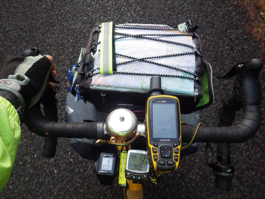
Not sure what kind of phone you use, but on a sunny day I can't see the screen on mine well enough to read it.
I use a Garmin GPS. It is readable in full sun with the backlight turned off. I have the most trouble with mine when the sun is low in the sky in early morning or late evening, then the angle of sunlight is low enough that it does not light up the screen very well and ambient light is still bright enough that the screen backlight is not as bright as I would have liked. But it is still readable, but I might have to stop to be able to read it well.
My Android phone, I use the Maps.Me app and the Komoots app. I use a Garmin on my handlebar while cycling and mostly use the Garmin for routing. I use the phone apps when sitting in the campsite to compare different routes if I did not like the looks of the route that my Garmin suggested.
Maps.Me, I load the maps on wifi and can use them off line. It has routing by car or by bike. Last time I tried the bike routing (months ago, maybe it is better now?) the bike routing was really poor, I dd not use it.
Komoots, I need a data connection to use that, or wifi. I only used that for routing when I was unsure of route.
In all cases, Garmin GPS, Maps.Me or Komoots, sometimes a local road on a paper map works better. When I decided to use a Maps.Me or Komoots route, I did not have the software or programming smarts to transfer a route to my Garmin, instead I would pick some points along the route that I wanted to take and tell the Garmin to go to those specific points, in which case I used the Garmin routing for shorter segments of where I wanted to go that day.
Regarding buying or accumulating free maps, and paper stuff in general, a lot of paper weighs a ton. I try to find good paper maps for each state (or province or country) that I am going in, but I try to avoid accumulating too much paper.
My Garmin, there are plenty of internet sources of maps, I download them to my computer, upzip them, install on my Garmin GPS. I do all that before I leave home for a trip.
I did a four week bike tour in Iceland and a five week tour in Canadian Maritimes, both times I did not have a local sim card for my phone. Thus, my phone was only good as a wifi device. My point is that you can get by pretty well with poor data coverage if you planned ahead.
I also have Google Voice with a phone number, Hangouts and Hangouts Dialer apps on my Android phone, with that I can make phone calls where I have wifi even if I do not have phone coverage. It is hard to call me with that, but at least i can make calls if I need to. I have used restaurant wifi to make phone calls that way.
Likes For Tourist in MSN:
07-26-20, 11:36 AM
#10
bicycle tourist
Note: Many of those areas without much phone coverage also don't have a dense road network, so turns are quite far apart and not uncommon that you'll follow the same highway all day.
In contrast, the trickiest spots I've found for navigation are in dense urban areas where I am looking for streets/one-ways, restricted roads and opening times for businesses. These also tend to correlate with areas with more phone service.
So what works for me in US and some extended tours abroad including areas without much phone service is a three part approach:
1. For something that gives me a more continuos info about distance/time/temperature - I like having a basic GPS mounted on my handlebars. In the lower 48 it is tough to find gaps more than a day long between services - but in places I've had those gaps I bring an extra battery pack to charge up. I also have some 3x5 cards for cases where I might scribble some route instructions like 35 miles to town and turn right to follow US 87, or service info like convenience stores at 23 miles, 52 miles and 61 miles. I copy that info when I am online and looking over potential routing.
2. For off-line access, I have phone or tablet with MAPS.ME. Typically, I'll pull that up to cross-check location. The phone isn't on continously but instead when I am uncertain and doing a quick check. The phone is in the handlebar bag otherwise.
3. For on-line access, I have an unlocked phone with dual SIMs. Overseas, I'll cycle through SIMs of the countries I pass through and having more than one is useful. In the US, I would suggest looking at some of the resellers and picking two with different networks. For example, go here and pick two using different carriers (https://en.m.wikipedia.org/wiki/List...work_operators). I've used Net10 but you may get better deals for your needs. With one phone and two SIMs on different networks you can get pretty good service - particularly if you consider the most likely use is areas with dense road choices and likely also phone service.
Now as far as maps go - I wouldn't necessarily buy all the maps from all the routes - but instead consider routes expect to spend considerable time - or with more complex routing, e.g. Pacific Coast route in Southern California crossing several large urban areas. You also don't need to buy all in advance. I have ordered some to be delivered "general delivery" address in upcoming city I knew I would pass through (I generally try to pick a city big enough the Post Office has reasonable hours but not so big that I have to figure out which of many Post offices it gets sent). Aside from Adventure Cycling maps, I also like having an occasional paper state map to lay out and do more general routing.
Likes For mev:
07-26-20, 11:38 AM
#11
Senior Member

Join Date: Apr 2011
Posts: 782
Mentioned: 1 Post(s)
Tagged: 0 Thread(s)
Quoted: 226 Post(s)
Liked 45 Times
in
32 Posts
maybe if you just keep it out of sun in a handle bar bag and leave the cover loose.
Likes For boomhauer:
07-26-20, 12:56 PM
#12
Senior Member
Join Date: Jan 2010
Posts: 39,198
Mentioned: 211 Post(s)
Tagged: 1 Thread(s)
Quoted: 18391 Post(s)
Liked 15,465 Times
in
7,306 Posts
As for waterproof cases, I have been using the same LIFEPROOF case for my iPhone since 2017. Worth the money. And it comes in many colors to match your panniers.
Likes For indyfabz:
07-26-20, 01:18 PM
#13
Banned
I toured, several Long tours , during times before phones became such a planet wide phenomenon .
Just yesterday when trying to call It was hard to even see the screen with the sun Up.
Good Luck..
Nowadays stow it in your handlebar bag ... stop and read it. , then put it away again & ride..
(latest in the top of the range Ortlieb bar bags have a mount with electrical contacts wired to your hub dynamo,
then put the 6v AC to USB DC converter, & the phone in the bag . the clear top will let you put the phone in, under it,
Bag still pops off to not leave the electronics unattended..)
...
Last edited by fietsbob; 07-30-20 at 03:19 PM.
07-26-20, 03:25 PM
#14
Senior Member
Join Date: Aug 2010
Location: Madison, WI
Posts: 11,170
Bikes: 1961 Ideor, 1966 Perfekt 3 Speed AB Hub, 1994 Bridgestone MB-6, 2006 Airnimal Joey, 2009 Thorn Sherpa, 2013 Thorn Nomad MkII, 2015 VO Pass Hunter, 2017 Lynskey Backroad, 2017 Raleigh Gran Prix, 1980s Bianchi Mixte on a trainer. Others are now gone.
Mentioned: 47 Post(s)
Tagged: 0 Thread(s)
Quoted: 3450 Post(s)
Liked 1,449 Times
in
1,130 Posts
What are your plans for energy conservation and power sources?
I occasionally hear of some newer type chargers that can power up a power bank really fast, but that has not been my experience. And I have heard of people that rely on solar panels, but I have only once actually met someone that laid out solar panels in a campground to charge things up.
Last summer, for the first half of my five week tour, I was self reliant on dynohub charging up my power bank, but as time went on my power bank power level kept decliing. I eventually figured out that I had a cable with high resistance between my dynohub/usb charger and my power bank. At that point fully charged up my power bank using the power supply in the laundry room at a campground and changed cables.
The next couple of weeks had no problems at all, finished my tour with all four power level LEDs on my powerbank lit, meaning a high level of charge.
Some suggestions, (1) use good cables, (2) minimize screen time on phone, (3) stay in airplane mode on phone or off as much as possible, and (4) only use a phone that is warm. I found that when I got on wifi to check the weather forecast in the morning, if my phone was in the 40s (F), my phone battery dropped power level a lot faster than when the phone was warm. I started warming up my phone in my sleeping bag before using it on cold mornings.
If you are interested, I wrote up what worked for me for power usage, inventory of electrics, etc., on a different website after my five week tour last summer. Yeah your tour is more than ten times longer, but if you have not given thought yet to your electrics, you might want to look at my summary. That write up is here:
Electrics that I use for bike touring - what works for me.
Likes For Tourist in MSN:
07-26-20, 08:24 PM
#15
Senior Member
Join Date: Mar 2011
Posts: 3,088
Mentioned: 7 Post(s)
Tagged: 0 Thread(s)
Quoted: 1034 Post(s)
Liked 1,285 Times
in
741 Posts
My Android phone, I use the Maps.Me app and the Komoots app. I use a Garmin on my handlebar while cycling and mostly use the Garmin for routing. I use the phone apps when sitting in the campsite to compare different routes if I did not like the looks of the route that my Garmin suggested.
Maps.Me, I load the maps on wifi and can use them off line. It has routing by car or by bike. Last time I tried the bike routing (months ago, maybe it is better now?) the bike routing was really poor, I dd not use it.
Komoots, I need a data connection to use that, or wifi. I only used that for routing when I was unsure of route.
Likes For phughes:
07-26-20, 08:35 PM
#16
Senior Member
Join Date: Sep 2007
Location: Far beyond the pale horizon.
Posts: 14,254
Mentioned: 31 Post(s)
Tagged: 0 Thread(s)
Quoted: 4242 Post(s)
Liked 1,342 Times
in
931 Posts
4) Phone service - According to MetroPCS coverage map I should have service approximately 80% of the trip. I'm planning on speaking with Metro about getting access to other carriers when not in a metro service area (parts of Arizona, Montana, etc...) Apparently for more money monthly this is an option. Any other suggestions?
It might be old info but Verizon might be best followed by ATT.
Cell phone access is spotty whatever network and will be worse in hilly/mountainous places (with low population).
Any “percent coverage” number will be an exaggeration.
Ideally, cell service would be a “nice to have” thing rather than something you expect to always work.
The adventure cycling maps would be useful for the places they map out. But you can sled much less for decent general maps. Make sure your maps are on the phone (don’t depend on maps that need a cell network).
Last edited by njkayaker; 07-26-20 at 08:45 PM.
Likes For njkayaker:
07-26-20, 10:05 PM
#17
Senior Member

I only use my phone for navigation about 20% of my ride. When I am in cities or a number of turns coming up on my route. For example, if I know to stay on a certain road for 20 km, then no need to navigation assistance. Normally, I keep the phone in the bag until needed, then it gets mounted.
07-27-20, 03:29 AM
#18
Senior Member
Join Date: Jan 2010
Posts: 39,198
Mentioned: 211 Post(s)
Tagged: 1 Thread(s)
Quoted: 18391 Post(s)
Liked 15,465 Times
in
7,306 Posts
Cell phone access is spotty whatever network and will be worse in hilly/mountainous places (with low population).
Any �percent coverage� number will be an exaggeration.
Ideally, cell service would be a �nice to have� thing rather than something you expect to always work.
I�ve been in plenty of places where I�ve technically had Verizon service, but the signal has been so weak that I could barely send a text. Accessing internet was impossible. And I�m not talking about just out west. There�s a campground in south Jersey I frequent where the signal is that weak, and NJ is the most densely populated state in the country. I remember a place in rural VT that was also like that. If I went to a certain part of the campground I could sometimes get a strong enough signal to send a text.
And the less you have to rely on your phone the less you have to worry about keeping it charged.
07-27-20, 04:16 AM
#19
Senior Member
Join Date: Sep 2007
Location: Far beyond the pale horizon.
Posts: 14,254
Mentioned: 31 Post(s)
Tagged: 0 Thread(s)
Quoted: 4242 Post(s)
Liked 1,342 Times
in
931 Posts
I’ve been in plenty of places where I’ve technically had Verizon service, but the signal has been so weak that I could barely send a text. Accessing internet was impossible. And I’m not talking about just out west. There’s a campground in south Jersey I frequent where the signal is that weak, and NJ is the most densely populated state in the country. I remember a place in rural VT that was also like that. If I went to a certain part of the campground I could sometimes get a strong enough signal to send a text.
Note that text can sometimes work were voice doesn’t (something you know but others might not).
Likes For njkayaker:
07-27-20, 05:50 AM
#20
Member
Thread Starter
Join Date: Apr 2011
Posts: 29
Mentioned: 0 Post(s)
Tagged: 0 Thread(s)
Quoted: 18 Post(s)
Liked 0 Times
in
0 Posts
I just want to say that I am so grateful for all of you! Thank you so much for all the detailed and well thought out replies to my original question.
I have a Verizon Samsung Galaxy phone as well (that's not active). Verizon does provide overall the best coverage nationwide though at a premium over most other carriers. The idea of carrying more than one sim card is an interesting one that had not occurred to me.
Keeping my devices charged is a non issue as I will have a solar charger.
07-27-20, 06:03 AM
#21
Senior Member
David78---when I brought up the usefulness of having a regular old bike computer, the advantages to having one are that given that you will probably plan your days ride beforehand and know the total distance, its an easy way to keep track of progress.
Perfectly good ones can be had for 25 bucks, and while there are wireless and wired ones, (Ive used both but prefer wired) the wired ones are fine (Ive never broken a wire) but more importantly the wired ones will last a super long time on a single small 2032 battery--6 months or a year--maybe not that long on an extended trip--but no matter, a long time so its a simple reliable method that helps with not using your phone all the time or as much, and simply is nice to know at a glance all the time of your distance progress.
think of it as a compliment to gps devices.
re maps, in the past, I've often picked up local or state maps at tourism places to have an overview of a large area. We often go into these places to use facilities or whatever, and sometimes these free maps are worth taking and keeping for the time that you are in the state and then discarding. Sure, some of these maps arent of much help to a touring cyclist, but sometimes they are.
have you read about dyno hubs to keep a battery bank charged? As someone else mentioned, there are always technical hiccups with these things, so researching all the details is needed, but folks do use them successfully so there has to be dependable setups out there.
Likes For djb:
07-27-20, 08:26 AM
#22
Senior Member
Join Date: Aug 2010
Location: Madison, WI
Posts: 11,170
Bikes: 1961 Ideor, 1966 Perfekt 3 Speed AB Hub, 1994 Bridgestone MB-6, 2006 Airnimal Joey, 2009 Thorn Sherpa, 2013 Thorn Nomad MkII, 2015 VO Pass Hunter, 2017 Lynskey Backroad, 2017 Raleigh Gran Prix, 1980s Bianchi Mixte on a trainer. Others are now gone.
Mentioned: 47 Post(s)
Tagged: 0 Thread(s)
Quoted: 3450 Post(s)
Liked 1,449 Times
in
1,130 Posts
Will you have a handlebar bag with a map case on it? I REALLY like having a paper map in my map case that is easy to refer to. A plastic case that keeps 98 percent of the rain off the map is nice to have.
I admit I have some bias here, I am a retired Geological Engineer, I worked with maps almost every day of my professional career, thus I probably over emphasize the importance of knowing where you are and where you are going and what is in between.
I admit I have some bias here, I am a retired Geological Engineer, I worked with maps almost every day of my professional career, thus I probably over emphasize the importance of knowing where you are and where you are going and what is in between.
Likes For Tourist in MSN:
07-27-20, 11:01 AM
#23
Senior Member
Join Date: Aug 2010
Location: Madison, WI
Posts: 11,170
Bikes: 1961 Ideor, 1966 Perfekt 3 Speed AB Hub, 1994 Bridgestone MB-6, 2006 Airnimal Joey, 2009 Thorn Sherpa, 2013 Thorn Nomad MkII, 2015 VO Pass Hunter, 2017 Lynskey Backroad, 2017 Raleigh Gran Prix, 1980s Bianchi Mixte on a trainer. Others are now gone.
Mentioned: 47 Post(s)
Tagged: 0 Thread(s)
Quoted: 3450 Post(s)
Liked 1,449 Times
in
1,130 Posts
Many years ago I bought a 3G phone that was dual sim, the frequencies were for Asia or Europe, not North America. Phones and frequencies and standards are different now, but if you shop for a dual sim phone, I suggest you make sure the frequencies that the phone is wired for are the frequencies used by your provider.
Likes For Tourist in MSN:
07-27-20, 11:31 AM
#24
bicycle tourist
Many years ago I bought a 3G phone that was dual sim, the frequencies were for Asia or Europe, not North America. Phones and frequencies and standards are different now, but if you shop for a dual sim phone, I suggest you make sure the frequencies that the phone is wired for are the frequencies used by your provider.
Some of these unlocked phones also enable both CDMA and GSM. Vendor pages such at this one also give clues of what US carriers work with which phones - https://www.motorola.com/us/carrier-compatibility
The larger issue I've found is sometimes phones are sold with SIMs but were "locked" rather than "unlocked" - so now I am extra careful to make sure I start with an unlocked phone.
Likes For mev:
07-27-20, 02:56 PM
#25
Senior Member
Join Date: Sep 2015
Location: QC Canada
Posts: 1,960
Bikes: Custom built LHT & Troll
Mentioned: 12 Post(s)
Tagged: 0 Thread(s)
Quoted: 837 Post(s)
Liked 149 Times
in
106 Posts
Personally, (1) I am somewhat jealous -- no enough free time for an extended tour, for the foreseeable future; (2) I tour with a Garmin Fenix 5 mounted on an out-front bar mount. Battery life is much much much better than a phone's (one order of magnitude better). Readable in direct sunlight, much more rugged. I also have a stem mount for my phone, used to navigate cities (the F5 doesn't have mapping capability. TbT navigation with breadcrumb display). More expensive models display maps, but screen size makes it challenging to interpret.
Have tried phone only. Water resistant S7. OK, but useless when it rains hard (drops are interpreted as finger pokes). This + energy requirements makes a phone less than ideal. A dedicated bike computer is more or less a single-use device whereas a smartwatch is useful in different settings (hiking, running, etc.)
Likes For gauvins:

