


Bike GPS
 11-12-19, 08:35 AM
#26
Senior Member

Join Date: Jul 2018
Location: USA
Posts: 2,190
Bikes: Ti, Mn Cr Ni Mo Nb, Al, C
Mentioned: 22 Post(s)
Tagged: 0 Thread(s)
Quoted: 942 Post(s)
Liked 527 Times
in
349 Posts
Are you saying that that Elemnt and Bolt require your phone to navigate because that is wrong. It synchs your routes from RWGPS, Kamoots, and gives you TBT directions. Go to your settings and you can see which maps have been downloaded to the unit.
 11-12-19, 08:43 AM
#27
Senior Member
Join Date: Apr 2008
Location: Salt Lake City, UT (Formerly Los Angeles, CA)
Posts: 1,145
Bikes: 2008 Cannondale Synapse -- 2014 Cannondale Quick CX
Mentioned: 5 Post(s)
Tagged: 0 Thread(s)
Quoted: 212 Post(s)
Likes: 0
Liked 83 Times
in
54 Posts
Looking around at finally pulling the trigger on a GPS. I've been doing alot of reading and seems like wahoo computers get great reviews. The wahoo element bolt gives a lot of bang for your buck. The wahoo roam seems like a lot of extra money it would be the upper end of my budget as well, but seems to have a few nicer fearures. The garmin's devices seem to have mixed reviews. Anyone thoughts and experiences would be great. Hoping for some sales for the holidays. I'm not a competitive cyclist by any stretch, I commute, want to be able to track or plan with turn by turn, speed, distance, tracking climbing etc, nothing crazy beyond that. Dont care about my heart rate, cadence or intervals.
Aside from that wart, it's been a great GPS, and I would recommend it or its successor the 830 anytime. The 820 has turn by turn routing with street names, integration with both Garmin and Strava routing, automatic uploads to your device, multiple ride profiles, realtime ride data sharing (share your location with a loved-one for example, as you're riding), integration with your phone's notifications as well as ability to read and respond to text messages, connectivity to sensors such as heart rate, power, cadence, speed, and even rear-facing proximity sensors.
The 830 is a refresh, with better screen than the 820, and a few other perks. If my 820 weren't less than a year old I'd upgrade to the 830.
If you are more concerned with mapping, and less with performance information, you might consider one of the 'Explore' models. The 1030 Explore is a really great GPS with a larger screen than the 8x0 series, but without the ability to connect external sensors such as heart rate. The 1030 (not Explore) has both sensor connectivity and larger screen.
Last edited by daoswald; 11-12-19 at 09:59 AM.
11-12-19, 09:12 AM
#28
Senior Member
11-12-19, 10:34 AM
#29

Senior Member

Join Date: Apr 2010
Location: Mountain View, CA USA and Golden, CO USA
Posts: 6,341
Bikes: 97 Litespeed, 50-39-30x13-26 10 cogs, Campagnolo Ultrashift, retroreflective rims on SON28/PowerTap hubs
Mentioned: 9 Post(s)
Tagged: 0 Thread(s)
Quoted: 550 Post(s)
Liked 325 Times
in
226 Posts
Automatically generated "left" and "right" turns can result from road squiggles in your mapping application. You won't notice it on the Wahoo if you don't have the map screen up which supports too few data fields to leave up and the Wahoo won't automatically change when a turn approaches like a Garmin that will highlight it in white.
You can't route to a point-of-interest like water (because it became 105 degrees in the sun) without your phone having internet access.
You'll need to have relevant map tiles downloaded to your phone or internet access to manually navigate because you can't pan to see where roads go when zoomed out, and to see what the names of those streets are where you'll turn.
You won't get navigation back to a course when forced to detour that keeps you off dead-end streets because the software doesn't know about roads, just your bread crumb trail.
You need a new Wahoo Roam or 10 year old Garmin to get that basic functionality. The Bolt and ELEMNT are the wrong tools for riding where you're not familiar with the roads and cellular coverage.
RWGPS wrong turns. The "slight right" isn't what gets displayed. Street signs with road names aren't always visible, especially after dark.


Garmin turn pop-up 500' before, showing just how far (or not) you'll be turning

switching from a more informative navigation screen

Last edited by Drew Eckhardt; 11-13-19 at 08:12 PM.
11-12-19, 06:00 PM
#30
Senior Member
Thread Starter
Join Date: Oct 2009
Location: upstate NY
Posts: 161
Bikes: Jamis renegade, surly big dummy, giant talon 29er
Mentioned: 0 Post(s)
Tagged: 0 Thread(s)
Quoted: 62 Post(s)
Likes: 0
Liked 42 Times
in
22 Posts
I have a Lezyne Mega XL that I�ve been using since spring. Looking at the above posts, I think I made a good choice. The Mega XL only cost $200, does turn-by-turn and has a battery life that is up to 48 hours (I�ve only gotten it up to about 30 hours). I used it on a 3 day bikepacking trip in August and never had to recharge it. Considering that I was camping without access to power, that was a plus. I could probably get 5 days or so out of it.
11-12-19, 06:13 PM
#31
Mad bike riding scientist

Join Date: Nov 2004
Location: Denver, CO
Posts: 27,362
Bikes: Some silver ones, a red one, a black and orange one, and a few titanium ones
Mentioned: 152 Post(s)
Tagged: 1 Thread(s)
Quoted: 6219 Post(s)
Liked 4,218 Times
in
2,365 Posts
Yes. You can download maps from a phone but you don�t need the phone to be connected to follow the maps.
__________________
Stuart Black
Plan Epsilon Around Lake Michigan in the era of Covid
Old School�When It Wasn�t Ancient bikepacking
Gold Fever Three days of dirt in Colorado
Pokin' around the Poconos A cold ride around Lake Erie
Dinosaurs in Colorado A mountain bike guide to the Purgatory Canyon dinosaur trackway
Solo Without Pie. The search for pie in the Midwest.
Picking the Scablands. Washington and Oregon, 2005. Pie and spiders on the Columbia River!
11-12-19, 06:16 PM
#32
Senior Member
Thread Starter
Join Date: Oct 2009
Location: upstate NY
Posts: 161
Bikes: Jamis renegade, surly big dummy, giant talon 29er
Mentioned: 0 Post(s)
Tagged: 0 Thread(s)
Quoted: 62 Post(s)
Likes: 0
Liked 42 Times
in
22 Posts
I'm sold. Backcountry_.com them on sale for for 159. Gonna order one tonight. It tells you your altitude but does it display % grade? Not a deal breaker just curious.
11-12-19, 06:55 PM
#33
Senior Member
Join Date: Jul 2007
Location: South shore, L.I., NY
Posts: 6,882
Bikes: Flyxii FR322, Cannondale Topstone, Miyata City Liner, Specialized Chisel, Specialized Epic Evo
Mentioned: 18 Post(s)
Tagged: 0 Thread(s)
Quoted: 3238 Post(s)
Liked 2,086 Times
in
1,181 Posts
11-12-19, 07:29 PM
#35
I don�t live in Tampa
Join Date: Jun 2014
Location: Atlanta, GA
Posts: 447
Bikes: 2014 Jamis Ventura Race, 2014 Cervelo P2, 2017 Raleigh Tamland 1, 2015 Jamis Trail X
Mentioned: 0 Post(s)
Tagged: 0 Thread(s)
Quoted: 151 Post(s)
Likes: 0
Liked 42 Times
in
31 Posts
one limitation to lezyne, unless they�ve updated recently, is the ability to send a route directly from Ridewithgps to the device over Bluetooth. That�s my favorite new feature with the Garmin.
11-12-19, 08:18 PM
#36
Senior Member
Unless you have an older android phone then the app doesn't work. I have the wahoo, the screen went mostly black in about 6 months fortunately they have a decent customer service and I got it replaced once I sent a pic of the screen.
Phones work if you live somewhere the sun hardly shines otherwise it is hard to read the screen and use a auxiliary battery if you ride more than a couple of hours.
11-13-19, 02:13 PM
#37
Senior Member
Join Date: Apr 2017
Location: Los Angeles, CA
Posts: 2,249
Bikes: 1964 Legnano Roma Olympiade, 1973 Raleigh Super Course, 1978 Raleigh Super Course, 1978 Peugeot PR10, 2002 Specialized Allez, 2007 Specialized Roubaix, 2013 Culprit Croz Blade
Mentioned: 68 Post(s)
Tagged: 0 Thread(s)
Quoted: 741 Post(s)
Liked 818 Times
in
421 Posts
I'm pretty happy with my Garmin 810. The screen could be brighter for day light use. It was a little buggy a few years ago, but after a few firmware updates, all good now. Battery life is OK for most rides, but has gone down a little after several years, still adequate for most days.
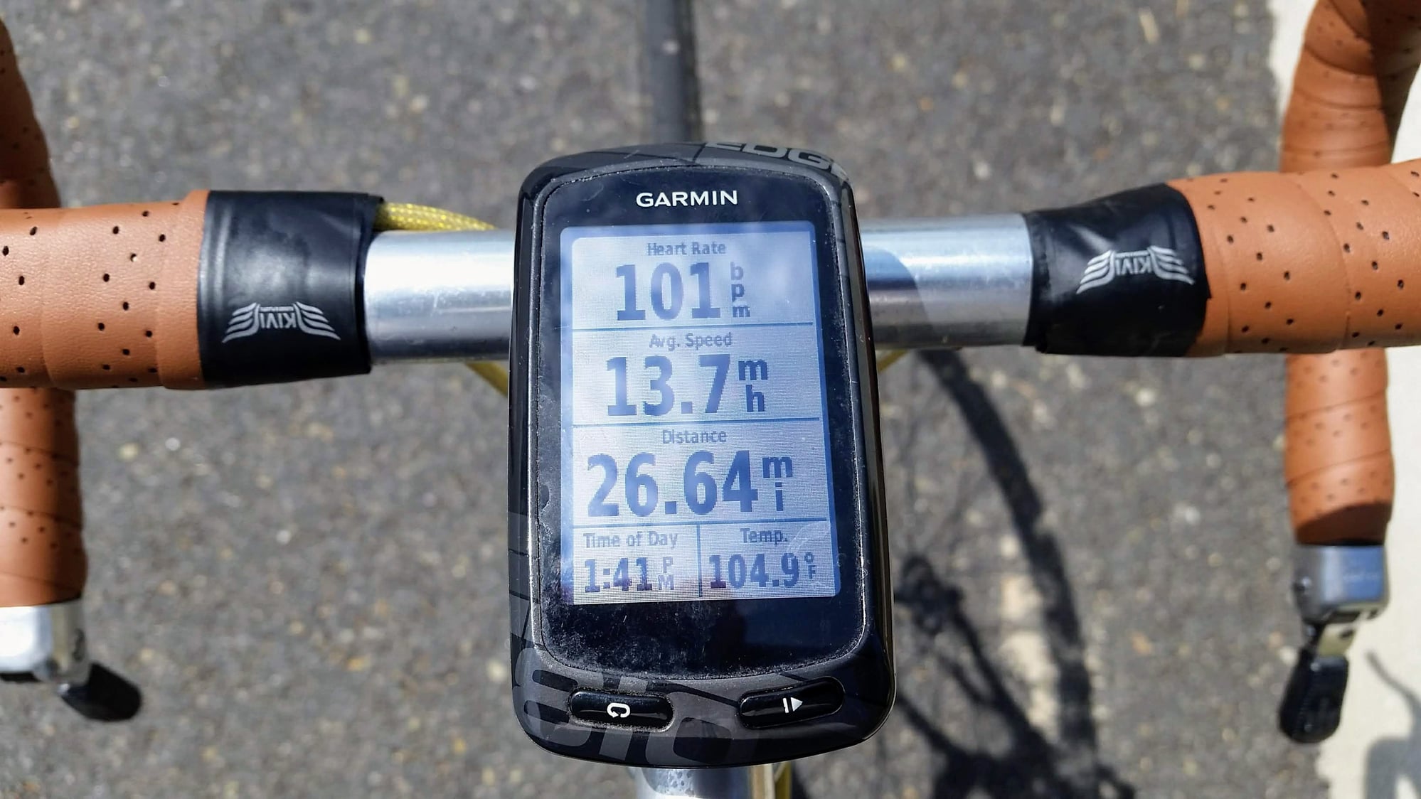
It shows big temp numbers on hot days. I was told that's because it's out in the sun, but then, so am I!
It shows big temp numbers on hot days. I was told that's because it's out in the sun, but then, so am I!
11-15-19, 01:17 PM
#38
Junior Member
As a satisfied Mega XL user I think you made a good choice and yes, it does have the ability to display %grade.
11-15-19, 01:35 PM
#39
Senior Member
Join Date: Sep 2019
Location: Portland
Posts: 1,115
Mentioned: 10 Post(s)
Tagged: 0 Thread(s)
Quoted: 451 Post(s)
Liked 364 Times
in
227 Posts
I am just using my LG and RWGPS. So far, I like it, except for the fact that a couple of times, when I review my ride, the "route" I have ridden seems to magically have diverted to someplace miles away from me and then returned. It looks ridiculous and the lines are perfectly straight. RWGPS suggested I look at whether battery saver was on (it wasn't) and also if there was a barometer function--there is not. Has anyone using a phone experienced this? If so, what did you do? Many thanks.
11-15-19, 08:46 PM
#41
Senior Member
Thread Starter
Join Date: Oct 2009
Location: upstate NY
Posts: 161
Bikes: Jamis renegade, surly big dummy, giant talon 29er
Mentioned: 0 Post(s)
Tagged: 0 Thread(s)
Quoted: 62 Post(s)
Likes: 0
Liked 42 Times
in
22 Posts
My mega XL came today and I did find the % grade. I set up my three! Screens of data, I've got speed and time and temp a.d a few more. A huge step of from my cat eye. I have made a few routes and loaded it up. I'm super happy with the functions and the negative reviews I've read about the buttons seems to be a non issues. As long as it tracks I'll be happy.
11-15-19, 08:51 PM
#42
Cycleway town

I don't want a readout on my bike. I sit up, and enjoy the world.
But that's not to say that certain info isn't interesting. I do occasionally use Strava on my phone, as well as Google maps, and it'd be interesting to know what others use for touring/sightseeing/commuting as I plan my errands/tasks etc and reflect on them as it suits.
But that's not to say that certain info isn't interesting. I do occasionally use Strava on my phone, as well as Google maps, and it'd be interesting to know what others use for touring/sightseeing/commuting as I plan my errands/tasks etc and reflect on them as it suits.
11-17-19, 07:49 AM
#43
Junior Member
I use my old iPhone 5s with no SIM card, and a variety of map apps, mounted to the bike with a Nite-Ize handlebar mount. Favorite map app is MTB-project. Fits the “cheap and cheerful” category for me.
11-17-19, 04:42 PM
#44
Senior Member
I recently succumbed and bought an Edge Explore, but I've always liked "cheap and cheerful".
11-17-19, 06:27 PM
#45
Senior Member
Join Date: Jul 2007
Location: South shore, L.I., NY
Posts: 6,882
Bikes: Flyxii FR322, Cannondale Topstone, Miyata City Liner, Specialized Chisel, Specialized Epic Evo
Mentioned: 18 Post(s)
Tagged: 0 Thread(s)
Quoted: 3238 Post(s)
Liked 2,086 Times
in
1,181 Posts
You can install apps (at least on an Apple) using WiFi. In fact stuff from the Apple store almost never likes using cell data only to download. I repurposed an iPhone 6 as a music player, pulled the SIM card and use WiFi.
11-17-19, 07:05 PM
#46
Junior Member
wifi. Yep. Battery will last about a day, same as if it was being used with a SIM card
Last edited by reconnaissance; 11-17-19 at 07:07 PM. Reason: Clarity
11-17-19, 08:42 PM
#47
Senior Member
Thread Starter
Join Date: Oct 2009
Location: upstate NY
Posts: 161
Bikes: Jamis renegade, surly big dummy, giant talon 29er
Mentioned: 0 Post(s)
Tagged: 0 Thread(s)
Quoted: 62 Post(s)
Likes: 0
Liked 42 Times
in
22 Posts
Got a ride in today with my Mega XL. Loved it, created a route I ride regularly and like the turn by turn. I did forget to turn tracking on so all data was lost. Next time.
11-18-19, 06:14 AM
#48
Senior Member
Even quite a few that have never used a Garmin.  I've had a Garmin 520 for 3 years and haven't had trouble. I like the color map screen and the Live Track feature. You're also not dependent on your phone to upload/delete maps or routes.
I've had a Garmin 520 for 3 years and haven't had trouble. I like the color map screen and the Live Track feature. You're also not dependent on your phone to upload/delete maps or routes.
11-19-19, 03:32 PM
#49
Senior Member
I have a SIM-less old 5 S I've downloaded offline maps and RWGPS onto. I'm going to fool around with that and see how it compares to the Edge Explore, which I've been getting accustomed to. It's so easy, a cave man could do it! (remember those ads?)
Reconnaissance, thanks to you too for the tip.
11-19-19, 03:39 PM
#50
Senior Member
Join Date: Jul 2007
Location: South shore, L.I., NY
Posts: 6,882
Bikes: Flyxii FR322, Cannondale Topstone, Miyata City Liner, Specialized Chisel, Specialized Epic Evo
Mentioned: 18 Post(s)
Tagged: 0 Thread(s)
Quoted: 3238 Post(s)
Liked 2,086 Times
in
1,181 Posts
Hah, an iPhone 6 is my "good" phone, inherited (like all its predecessors) from my daughter. Wait a minute, something is backwards here........
I have a SIM-less old 5 S I've downloaded offline maps and RWGPS onto. I'm going to fool around with that and see how it compares to the Edge Explore, which I've been getting accustomed to. It's so easy, a cave man could do it! (remember those ads?)
Reconnaissance, thanks to you too for the tip.
I have a SIM-less old 5 S I've downloaded offline maps and RWGPS onto. I'm going to fool around with that and see how it compares to the Edge Explore, which I've been getting accustomed to. It's so easy, a cave man could do it! (remember those ads?)
Reconnaissance, thanks to you too for the tip.