


Source for gravel / dirt routes (not MTB) in Seattle, Puget Sound area?
 08-15-20, 03:55 PM
#1

Senior Member
Thread Starter

Source for gravel / dirt routes (not MTB) in Seattle, Puget Sound area?
Hi - I'm just starting to explore the realm of off-road / gravel / dirt riding around the Seattle / Washington state area and wanted to know if anyone knew of a good source of maps/routes.
I realize the term gravel-bike riding can be ambiguous. For my purposes, for "off-road/gravel" I mean (a) unpaved routes that wouldn't require a full-on mountain bike to have fun on but (b) a bit more rugged than a road bike with 32c tires. Something suitable for a gravel / all-terrain / all road bike. I'm pretty experienced riding road bikes around the state, and have a mountain bike that I take to some of the King County mountain bike parks, but would like to explore some of the riding people do on gravel trails, old logging roads, etc.
So far I haven't found a single trove of routes. There's a site called gravelmap.com that has a few routes, but seems to be missing a lot of what I see riders talking about online. The Evergreen Mountain Bike Alliance website has a lot of mountain bike trails, a little hard for me to pick through which trails are suitable for mountain bike only (partly because I don't think I understand their trail-grading). There appear to be a lot of great routes on mapmyride.com, strava and ridewithgps.com, but you kind of have to hunt around for good "gravel bike" routes.
If I just need to keep hunting around, that's fine (I can find more routes than I have time to ride anyway, just hunting around on the sites mentioned above), but I thought somewhere here might have a good library of routes, club website or other resources that would be helpful.
Thanks!
 08-17-20, 11:43 AM
#2
Senior Member
I've been focusing on following Stravas of cyclists that I know do gravel rides for inspiration. Particularly on the west side of the sound, there are lots of good routes out into the Olympics. Most of my intro-to-gravel rides have been in the Stottlemeyer trail system in Port Gamble. Not big mileage rides, but some reasonably diverse surfaces to start getting my feet wet off-road.
08-17-20, 11:13 PM
#3
Senior Member
Join Date: Mar 2010
Location: Seattle, WA
Posts: 23,208
Mentioned: 89 Post(s)
Tagged: 0 Thread(s)
Quoted: 18883 Post(s)
Liked 10,646 Times
in
6,054 Posts
CalTopo has a layer for jeep trails, which are basically very rough roads. They have a lot of other fantastic layers too, probably the best route planning tool available.
WTA can give you a lot of good ideas. Which is ironic. Just follow almost any directions.
I think you can browse segments in Garmin Connect and filter for gravel ones.
People in here have good recommendations.
WTA can give you a lot of good ideas. Which is ironic. Just follow almost any directions.
I think you can browse segments in Garmin Connect and filter for gravel ones.
People in here have good recommendations.
08-18-20, 01:25 PM
#4
Senior Member
Thread Starter
CalTopo has a layer for jeep trails, which are basically very rough roads. They have a lot of other fantastic layers too, probably the best route planning tool available....WTA can give you a lot of good ideas....I think you can browse segments in Garmin Connect....People in here have good recommendations.
I am finding lots and lots of individual suggestions at route mapping sites, and I think that is probably enough for a lifetime of riding. But would still love to find any lists or curated libraries if anybody knows of a great go-to archive or list of lists.
For example, for road riding, I have long admired this library put together by the Seattle Bicycle Club - many different rides leaving from multiple spots, rides all over the the State of Washington, etc... Seattle Bicycle Club - Maps Library
Last edited by BengeBoy; 08-18-20 at 04:27 PM.
08-25-20, 10:51 AM
#5
Senior Member
Join Date: Mar 2010
Location: Seattle, WA
Posts: 23,208
Mentioned: 89 Post(s)
Tagged: 0 Thread(s)
Quoted: 18883 Post(s)
Liked 10,646 Times
in
6,054 Posts
Thanks for the leads. I've used WTA for hiking, hadn't thought of it for bike riding. CalTopo is news to me, will spend time on that. I am also looking at OnX Offroad (OnX started as a service for hunters, now expanding into offroad motorized routes, wondering if you can filter for bikes only..)
I am finding lots and lots of individual suggestions at route mapping sites, and I think that is probably enough for a lifetime of riding. But would still love to find any lists or curated libraries if anybody knows of a great go-to archive or list of lists.
For example, for road riding, I have long admired this library put together by the Seattle Bicycle Club - many different rides leaving from multiple spots, rides all over the the State of Washington, etc... Seattle Bicycle Club - Maps Library
Are you only interested in King County, or further out too?
08-25-20, 11:09 AM
#6
Senior Member
Thread Starter
I continue to search around on various sites for guidance -- as I said above, my hunting around on the sites I've mentioned I think I can find more than a lifetime of riding, but would still be an interesting opportunity from someone to put together a single home for this, e.g., a list of rides by length/difficulty by region. E.G., "Seattle Forrest's Gravel Bible - The Ultimate Guide to Gravel Rides in Washington."
Likes For BengeBoy:
08-26-20, 01:06 PM
#7
Senior Member
Join Date: Mar 2010
Location: Seattle, WA
Posts: 23,208
Mentioned: 89 Post(s)
Tagged: 0 Thread(s)
Quoted: 18883 Post(s)
Liked 10,646 Times
in
6,054 Posts
@BengeBoy I actually started working on something like that a couple years ago, but gave up when I realized how much work it would be. I have pages of notes scribbled on paper nearby.
What's your preference on ride length, hilliness, and anything on scenery? I'll post the best stuff I've got for you.
What's your preference on ride length, hilliness, and anything on scenery? I'll post the best stuff I've got for you.
08-26-20, 08:36 PM
#8
Senior Member
Thread Starter
@BengeBoy I actually started working on something like that a couple years ago, but gave up when I realized how much work it would be. I have pages of notes scribbled on paper nearby.
What's your preference on ride length, hilliness, and anything on scenery? I'll post the best stuff I've got for you.
What's your preference on ride length, hilliness, and anything on scenery? I'll post the best stuff I've got for you.
By the way, as I explore more of the Facebook group "Northwest Gravel Riders" I see more and more of the routes they recommend. If you join the group and do a search, you can find they have a list of recommended rides, it's about a dozen long. A lot of their recommended rides are in the Snoqualmie Valley area, but there are others as well. They seem to track a lot of rides in RidewithGPS.com. A ride they seem to recommend a lot is this one: https://ridewithgps.com/routes/32538977
Likes For BengeBoy:
08-28-20, 01:49 PM
#9
Senior Member
Join Date: Mar 2010
Location: Seattle, WA
Posts: 23,208
Mentioned: 89 Post(s)
Tagged: 0 Thread(s)
Quoted: 18883 Post(s)
Liked 10,646 Times
in
6,054 Posts
@BengeBoy Ironically I don't know much about gravel options in King County, and especially about trail options like the SVT. So I'm glad you know those already. Unfortunately a lot of what I've got is at the edge of how far you're willing to drive. I use a Garmin, so their route planning tool is my go to, but if you can't get any of the routes to open let me know and I'll figure out how to export them to RwGPS for you. Finally, I have pics from some of these so let me know if you'd like to see any, for now I don't want to clutter your thread.
North Bend
Unfortunately a lot of what I've got is at the edge of how far you're willing to drive. I use a Garmin, so their route planning tool is my go to, but if you can't get any of the routes to open let me know and I'll figure out how to export them to RwGPS for you. Finally, I have pics from some of these so let me know if you'd like to see any, for now I don't want to clutter your thread.North Bend
- Snoqualmie / Tokul Loop - 27 miles, 1,500 feet gain. Mostly pavement with a gravel powerline trail. Fun ride, but the last one on this list I'd recommend; I'm including it because it's a short drive.
- Middle Fork Snoqualmie - ???. They paved MFK road, but the road to the Dutch Miller TH is still gravel. 28 mm tires were just barely doable. Rainforest scenery. I don't know if MFK road is currently open to cars, probably is to bikes.
- Tinkham Road / Hansen Climb - 16 miles, 2,200 feet gain. Some views of the river, peek-a-boo views of peaks, lot of rainforest, and a neat trestle bridge. Lot of auto traffic in the summer. It's fun, but not the best one on the list.
- Keechelus Lake Loop - 21 miles, 1,700 feet gain. Great scenery (peaks, big lake) on the Iron Horse section. The woods are maybe a little boring, but you probably won't see another person up there so the sense of solitude can give it a different kind of feeling. Popular XC ski loop.
- Stampede Pass from Hyak - 22 miles, 1,800 feet gain. This is the anti loop version of the above, with a side trip to a historic pass.
- Amabilis Mountain - 11 miles, 2,100 feet gain . Peek-a-boo views of the lake. There's a loop option from the summit. Doesn't get much summer use.
- Lost Lake Loop - 17 miles, 1,700 feet gain. Lost Lake is pretty, I enjoyed seeing more of the area. It was downright unpleasant on 28 mm tires, I'd want at least 40s.
- Keechelus Lake has a lot of dirt roads. It's all climbing. I had trouble with what looked like a loop on the map and was a dead end when I got there, so I avoid riding here.
- Salmon la Sac has a lot of good options, but they're a bit out of your driving range. The drive takes longer than it looks like on the map.
- North Fork Road - 32 miles, 2,200 feet gain, but that includes a mile or two of pavement. Peak views, a pretty river, open forest, nice cascade at the end. Western larches go off in late October, but the road can be snowy by then.
- Loop option - 22 miles, 2,300 feet gain. This was a lot of fun. Involved something that looked like a road at the top, but more like a trail at the bottom. I spent half the ride being lost, it's very off the beaten path, I thought that was fun but in a different mood it could be stressful.
- Middle and West Forks - depends. Clearly don't follow my path on this one, but if you bring a map you can have a good ride up there. One of the roads basically disappears and you ride across a meadow for a few hundred yards.
- Lot of other options, there are gravel roads closed to cars and gated. You can make big loops. This whole region is outside your preferred driving range, but it's really beautiful, full of meadows, rivers, waterfalls, and has wildflowers and some big peak views.
- Liberty Loop - 37 miles, 3,700 feet gain. This is a mix of gravel and pavement, the lap markers show where the surface changes. Doesn't have to be done as a loop to be enjoyable. Not as scenic as others, but neat if you're interested in history.
- Mission Peak - depends. Fantastic and varied scenery. You don't have to go anywhere near the peak to enjoy this one, I've only done the first 12 or so miles. Go in June or July for the wildflowers and/or late October for the larches. Road is hard packed dirt, but has ruts, I did it on 28 mms and was mostly comfortable with them, but had to slow down in places where the road was bad.
- There are a lot of great ride options here, some as loops. Most of the ski trails can be done on narrowish tires. The pass is 110 miles from Seattle so it's not an every weekend destination.
- Icicle Road - depends where you start. Best scenery is on the paved road, nice forest and river views plus less traffic on the dirt. Western larches in late October.
- Phelps Creek / Chiwawa River Road - approx. 44 miles, 2,700 feet gain. Less if you start at the end of the pavement. Beautiful forest and river with some peak views.
Ruby Creek / Camas Land - 18 miles. Haven't done this yet. - Ardenvoir - 50 miles, 7,000 feet gain. Ideal to meet a car at the halfway point.
- Entiat River - 76 miles, 4,700 feet gain, much shorter if you start at the end of the pavement. Pretty, but not as spectacular as other options.
- Whitehorse Trail - 41 miles, 1,000 feet gain. Only MUP on this list. Construction finished this spring. Meandering river, cool bridges, views of a big glaciated mountain, the Oso memorial. Have lunch at the Burger Barn in Darrington before heading back, they have outdoor seating with a view. Watch out for pinch flats crossing the bridges.

- North Mountain Loop - 26 miles, 2,300 feet gain including a wrong turn. This has some fantastic views of Whitehorse.
- North Mountain Climb - 28 miles, 3,900 feet gain. Ends at a historic fire lookout. If you put in the effort to get this far, you really need to walk up the stairs and enjoy the jaw dropping 360 degree view from the tower. There will be auto traffic on the road because of the MTB trails.
- White Chuck Loop - 46 miles, 3,200 feet gain. I haven't done this, @HTupolev has.
- Mountain Loop Highway - depends. You can leave from Darrington and cover about 10 miles of pavement along the way, or park where the gravel starts. Turn around at Barlow Pass where the pavement starts again.
- Slate Peak - depends where you start. For the full experience, start at the Mazama store. Road goes from paved to gravel in about 10 miles, so that's a good place to start too. I was short on time and started where the scenery gets really nice. This is one of the most scenic roads anywhere. Go in spring for the wildflowers (road tends to melt out around the 4th of July) and/or fall (the second weekend in October) for the larches. But definitely go.
- Rendezvous Loop - depends. There are several connecting dirt roads you can use to make a loop from Winthrop to Mazama. You can reserve any of the huts along the way and enjoy a multi day ride without camping. I've mostly only been here on skis.
- Chewuch / 30 Mile - 58 miles, 3,300 feet gain from Winthrop, less from the end of the pavement. Lovely river, open forest, and then an extensive burn zone with a somber memorial. Go in spring for wildflowers or autumn for the color, avoid in summer because of the heat and lack of shade.
- Tiffany Springs or Freezeout Ridge - depends where you start. Scenery is excellent, lot of wildflowers, immense burn at the top. I've only been up here in a car to hike. Rough road.
- Winthrop / Twisp Loop via Elbow Coulee - 27 miles, 1,900 feet. Mostly pavement. Nice, varied scenery with rivers, peaks, cliffs, rolling hills, and wildflowers in April and May.
- Loup Loup Loop - 35 miles, 3,200 feet gain from Twisp. Go clockwise so that you climb on gravel and descend on the highway. Or turn around and go back down on the gravel too, but this section of highway is less used and the drivers are all courteous.
- Conconully GravelCentury - This one is really just here to make the others look reasonable.
- This entire region is way out of your acceptable driving range, and really makes sense as a long weekend stay to make up for the drive. There are great hotesl and campgrounds here.
- Tieton Lasso Loop (White Pass) - There are a lot of options in here. Long drive, nice scenery.
- Bacon Creek (Newhalem) - 12 miles, 1,800 feet gain. I haven't been up here yet, and want to change that.
- Cascade River Road (Marblemount) - 44 miles, 4,700 feet gain from Marblemount, less from the end of the pavement ~10 miles up. River and rainforest below, dramatic peak views with hanging glaciers above. Can be very hot in summer.
- Lake Cavanaugh Loop (Oso) - 40 miles, 1,800 feet gain . Only part gravel.
- Baker Lake Road - I haven't done any research on this yet, heard it's great.
Likes For Seattle Forrest:
08-28-20, 01:54 PM
#10
Senior Member
Join Date: Mar 2010
Location: Seattle, WA
Posts: 23,208
Mentioned: 89 Post(s)
Tagged: 0 Thread(s)
Quoted: 18883 Post(s)
Liked 10,646 Times
in
6,054 Posts
I'll come back when I have some downtime and add some photos for some of the ^^^ routes. I'm mostly in it for the scenery, so pics help me choose.
08-28-20, 02:03 PM
#11
Senior Member
Thread Starter
Let me now when you publish your book of PNW bike routes, I'll come to the launch party to get an autographed copy.
Likes For BengeBoy:
08-28-20, 04:20 PM
#12
Senior Member
Join Date: Mar 2010
Location: Seattle, WA
Posts: 23,208
Mentioned: 89 Post(s)
Tagged: 0 Thread(s)
Quoted: 18883 Post(s)
Liked 10,646 Times
in
6,054 Posts
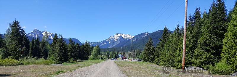
North Bend
- Snoqualmie / Tokul Loop - 27 miles, 1,500 feet gain. Mostly pavement with a gravel powerline trail. Fun ride, but the last one on this list I'd recommend; I'm including it because it's a short drive.


Again most of that ride is paved. And those switchbacks were too tight for me!
North Bend
- Middle Fork Snoqualmie - ???. They paved MFK road, but the road to the Dutch Miller TH is still gravel. 28 mm tires were just barely doable. Rainforest scenery. I don't know if MFK road is currently open to cars, probably is to bikes.


Most of the road looked better than that last pic, a few sub alpine lakes like that and one spot where a creek dumped a lot of rocks on the road were the worst of it.
The last I heard, there was a washout that destroyed the road last winter. I don't know if it's open yet. If you want to ride there, call the North Bend FS Ranger Station before you leave to make sure the road is open to bikes.
Likes For Seattle Forrest:
08-28-20, 04:49 PM
#13
Senior Member
Join Date: Mar 2010
Location: Seattle, WA
Posts: 23,208
Mentioned: 89 Post(s)
Tagged: 0 Thread(s)
Quoted: 18883 Post(s)
Liked 10,646 Times
in
6,054 Posts
Snoqualmie Pass
- Keechelus Lake Loop - 21 miles, 1,700 feet gain. Great scenery (peaks, big lake) on the Iron Horse section. The woods are maybe a little boring, but you probably won't see another person up there so the sense of solitude can give it a different kind of feeling. Popular XC ski loop.


Likes For Seattle Forrest:
08-29-20, 12:51 AM
#14
Senior Member
Whitehorse Trail - 41 miles, 1,000 feet gain. Only MUP on this list. Construction finished this spring.
Construction finished this spring.All the way from Trafton to Darrington is done, however. All of that railroad ballast and wilderness has been replaced with crushed rock, and a bit of pavement.


I'm not sure as to the current conditions, but I do know of at least one person having ridden it this year.


Unless you stick to a few MUPs, PNW gravel is very heavily mountainous. When you're not on paved roads, it's liable to be very heavily up-and-down, with some very steep sustained gradients at times. It rarely demands a mountain bike, but don't hesitate to put seriously low gearing on your bike if your legs want another downshift. Just about everybody who gets into gravel around here ends up settling on lower gearing than they initially thought they'd be fine with.
Likes For HTupolev:
08-29-20, 10:56 AM
#15
Senior Member
Join Date: Mar 2010
Location: Seattle, WA
Posts: 23,208
Mentioned: 89 Post(s)
Tagged: 0 Thread(s)
Quoted: 18883 Post(s)
Liked 10,646 Times
in
6,054 Posts
08-29-20, 11:22 AM
#16
Senior Member
Join Date: Mar 2010
Location: Seattle, WA
Posts: 23,208
Mentioned: 89 Post(s)
Tagged: 0 Thread(s)
Quoted: 18883 Post(s)
Liked 10,646 Times
in
6,054 Posts
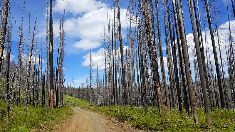
Teanaway
- North Fork Road - 32 miles, 2,200 feet gain, but that includes a mile or two of pavement. Peak views, a pretty river, open forest, nice cascade at the end. Western larches go off in late October, but the road can be snowy by then.


Last pic is the end of the road. MTBs are allowed on the trails here, wouldn't want to take a gravel bike any further.
Teanaway
- Loop option - 22 miles, 2,300 feet gain. This was a lot of fun. Involved something that looked like a road at the top, but more like a trail at the bottom. I spent half the ride being lost, it's very off the beaten path, I thought that was fun but in a different mood it could be stressful.


Teanaway
- Middle and West Forks - depends. Clearly don't follow my path on this one, but if you bring a map you can have a good ride up there. One of the roads basically disappears and you ride across a meadow for a few hundred yards.

Middle Fork Teanaway

There are a lot of open views of the sky in here.

Likes For Seattle Forrest:
08-29-20, 11:28 AM
#17
Senior Member
Thread Starter
Unless you stick to a few MUPs, PNW gravel is very heavily mountainous. When you're not on paved roads, it's liable to be very heavily up-and-down, with some very steep sustained gradients at times. It rarely demands a mountain bike, but don't hesitate to put seriously low gearing on your bike if your legs want another downshift. Just about everybody who gets into gravel around here ends up settling on lower gearing than they initially thought they'd be fine with.
08-29-20, 12:13 PM
#18
Senior Member
Join Date: Mar 2010
Location: Seattle, WA
Posts: 23,208
Mentioned: 89 Post(s)
Tagged: 0 Thread(s)
Quoted: 18883 Post(s)
Liked 10,646 Times
in
6,054 Posts
Blewett Pass
- Mission Peak - depends. Fantastic and varied scenery. You don't have to go anywhere near the peak to enjoy this one, I've only done the first 12 or so miles. Go in June or July for the wildflowers and/or late October for the larches. Road is hard packed dirt, but has ruts, I did it on 28 mms and was mostly comfortable with them, but had to slow down in places where the road was bad.

Road surface is also varied here. Mostly dirt with rocks embedded and showing through. Higher up, it's rutted in more and more places.

Most of the trees that survived the 2012 Table Mountain Fire are western larches. These go off during the second half of October. They look best in direct sun, and Blewett gets reliably better weather than we do (but still gets storms). It's very much worth the drive to see them on a sunny day. FYI it might be 25F at night and 70+ F during the day in late October so if you want an early start, plan accordingly.
Road 9712, about 5 miles from Blewett Pass. Mount Stuart and the Enchantment Range in the background.


Blewett Pass
- Liberty Loop - 37 miles, 3,700 feet gain. This is a mix of gravel and pavement, the lap markers show where the surface changes. Doesn't have to be done as a loop to be enjoyable. Not as scenic as others, but neat if you're interested in history.

The woods are more open than on our side of the crest.
 08-30-20, 09:57 PM
#19
Squeaky Wheel

If you follow the map on this one, it's going to take you up a thousand foot climb to the end of the road, and then turn around and come back down. That was supposed to go through to Ellensburg, but doesn't. I think most people would probably avoid that if they knew going up wasn't going to get them anywhere. There's a nice view from the top though.
There are many possible loops off Blewett Pass, but the roads up there can be pretty rugged in places. A great fall ride is from Blewett Pass to Lion Rock, as described here: https://wenatcheeoutdoors.org/2018/07/05/lion-rock/
I've ridden it on my mountain bike and even then still had to push a couple of spots. But man, it's really beautiful up there (wear orange during hunting season, you'll run into plenty of motorized users on weekends. They have always been unfailingly polite to me. During the week you'll have the place to yourself).
Another gravel riding area around here is the Taneum, south of Cle Elum. Go onto the Strava Global Heatmap and look at the well-ridden routes up E. Taneum Rd. and Westside Rd. I've not been up there yet but have seen photos from friends who have any it looks amazing.
Likes For woodway:
09-01-20, 12:12 PM
#20
Senior Member
Join Date: Mar 2010
Location: Seattle, WA
Posts: 23,208
Mentioned: 89 Post(s)
Tagged: 0 Thread(s)
Quoted: 18883 Post(s)
Liked 10,646 Times
in
6,054 Posts
But if anyone disagrees, like if it's too much scrolling, or harder to find actual advice and conversation, let me know and I'll delete them.
09-01-20, 12:23 PM
#21
Senior Member
Join Date: Mar 2010
Location: Seattle, WA
Posts: 23,208
Mentioned: 89 Post(s)
Tagged: 0 Thread(s)
Quoted: 18883 Post(s)
Liked 10,646 Times
in
6,054 Posts
You rode right past my house on this ride SF. I go up that climb onto Lookout Mountain on a regular basis (on my mountain bike) as a quick workout
There are many possible loops off Blewett Pass, but the roads up there can be pretty rugged in places. A great fall ride is from Blewett Pass to Lion Rock, as described here: https://wenatcheeoutdoors.org/2018/07/05/lion-rock/
I've ridden it on my mountain bike and even then still had to push a couple of spots. But man, it's really beautiful up there (wear orange during hunting season, you'll run into plenty of motorized users on weekends. They have always been unfailingly polite to me. During the week you'll have the place to yourself).
Another gravel riding area around here is the Taneum, south of Cle Elum. Go onto the Strava Global Heatmap and look at the well-ridden routes up E. Taneum Rd. and Westside Rd. I've not been up there yet but have seen photos from friends who have any it looks amazing.
I can't agree more with "But man, it's really beautiful up there �" I'll say I didn't expect it to be, and didn't really enjoy my first couple visits. I don't know if it's that I chose the wrong times and places to visit, or if getting older (and in Seattle) has allowed me to appreciate it more.
And it's funny I rode by your house. A lady on the local hiking forum told me the same thing. I rode a loop from Cle Elum up 970 & 97 to Ellensburg, and then back up 10. Ran out of water, and there isn't a store in Thorpe. Lady told me I should have knocked on her door, and used the hose if no one was home. Exactly what I would have done, if I had known she lived there when I suffering back up that hill with no water.
09-01-20, 11:58 PM
#22
Senior Member
Thread Starter
FYI, just ran across this site - Bikepacking - that has routes in the US and abroad. Many are multi-day trips. Here are their routes for the Pacific Northwest; they have a filter for "allroad/gravel;" I think some of these might be for mountain bikes:
https://bikepacking.com/locations/northwest/
https://bikepacking.com/locations/northwest/
Likes For BengeBoy:
09-09-20, 01:16 PM
#23
Junior Member

Great thread and some nice links/info.
Here's another site with info on some gravel rides in WA/OR. called Our Mother the Mountain. HOME ? Our Mother The Mountain
Here's another site with info on some gravel rides in WA/OR. called Our Mother the Mountain. HOME ? Our Mother The Mountain
09-17-20, 01:23 PM
#24
Senior Member
Thread Starter
FYI, ran across this bike shop in Olympia that organizes gravel rides in the area. They have a list of 12 recommended gravel routes on their website (haven't looked at them all, but they seem to be in the Olympia area, as you might imagine):
Local Rides
[there are also recommended road rides and a link to MTB routes on this page as well]
Thanks to the shop, which is Joy Ride Bicycles:
https://www.joyridebicycles.com/
Local Rides
[there are also recommended road rides and a link to MTB routes on this page as well]
Thanks to the shop, which is Joy Ride Bicycles:
https://www.joyridebicycles.com/
10-19-20, 05:15 PM
#25
Senior Member
Thread Starter
There's an online site called "Northwest in Motion" about running, hiking, mountain biking and gravel biking. They had a few a few weeks ago about the growth of gravel biking, and profile 4 cyclists and some of their favorite routes:
https://northwest.motion.social/2020...fects-the-pnw/
One rider alone provide a link to his library of 31 (!) gravel routes on RidewithGPS.com - this is pretty impressive:
https://ridewithgps.com/events/134823-sog
https://northwest.motion.social/2020...fects-the-pnw/
One rider alone provide a link to his library of 31 (!) gravel routes on RidewithGPS.com - this is pretty impressive:
https://ridewithgps.com/events/134823-sog