


Bike App for distance between lead and sweep
 03-03-19, 04:28 PM
#1
Senior Member
Thread Starter
Bike App for distance between lead and sweep
I'm curious if there is any good app that can show realtime distance between two people. I've tried the paid version of ridewithgps and whatsapp and quite a few other apps. The lag times are are pretty high and results doen't update quickly enough to be useful. does anyone know of a preferably free app that measures distance that way. it needs to be free since i need to convince someone else to try to use it. I do some coding and i'm curious about possibly writing an app that helps me understand where the lag time occurs with these kinds of apps.
 03-03-19, 04:40 PM
#2
Senior Member
Join Date: Jul 2007
Location: South shore, L.I., NY
Posts: 6,857
Bikes: Flyxii FR322, Cannondale Topstone, Miyata City Liner, Specialized Chisel, Specialized Epic Evo
Mentioned: 18 Post(s)
Tagged: 0 Thread(s)
Quoted: 3221 Post(s)
Liked 2,043 Times
in
1,169 Posts
Only thing I know that does this is recent Garmin cycling computers that have the ability to track the locations of other designated Garmin devices. I think it’s called Group Track.


 03-05-19, 01:12 PM
#5

Senior Member

Join Date: Jun 2011
Location: Tampa, Florida
Posts: 5,585
Bikes: 2017 Colnago C-RS, 2012 Colnago Ace, 2010 Giant Cypress hybrid
Mentioned: 3 Post(s)
Tagged: 0 Thread(s)
Quoted: 408 Post(s)
Liked 122 Times
in
85 Posts
Originally Posted by preferdownhill
I'm curious if there is any good app that can show realtime distance between two people. I've tried the paid version of ridewithgps and whatsapp and quite a few other apps. The lag times are are pretty high and results doen't update quickly enough to be useful. does anyone know of a preferably free app that measures distance that way. it needs to be free since i need to convince someone else to try to use it. I do some coding and i'm curious about possibly writing an app that helps me understand where the lag time occurs with these kinds of apps.
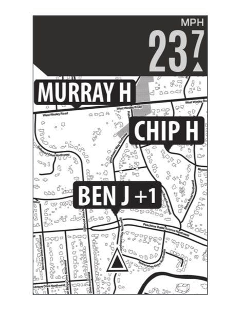
On my Bolt, I can see other riders that are using a Bolt or an Elemnt but as the image above shows, the riders are further away than just a few riders behind. If a rider in my group has a Bolt, the tag are usually on top of each other so you really can't tell what the exact distance is.
__________________
HCFR Cycling Team
Ride Safe ... Ride Hard ... Ride Daily
2017 Colnago C-RS
2012 Colnago Ace
2010 Giant Cypress
HCFR Cycling Team
Ride Safe ... Ride Hard ... Ride Daily
2017 Colnago C-RS
2012 Colnago Ace
2010 Giant Cypress
03-05-19, 01:22 PM
#6
Senior Member
Join Date: Mar 2010
Location: Seattle, WA
Posts: 23,208
Mentioned: 89 Post(s)
Tagged: 0 Thread(s)
Quoted: 18883 Post(s)
Liked 10,646 Times
in
6,054 Posts
I'm curious if there is any good app that can show realtime distance between two people. I've tried the paid version of ridewithgps and whatsapp and quite a few other apps. The lag times are are pretty high and results doen't update quickly enough to be useful. does anyone know of a preferably free app that measures distance that way. it needs to be free since i need to convince someone else to try to use it. I do some coding and i'm curious about possibly writing an app that helps me understand where the lag time occurs with these kinds of apps.
03-05-19, 06:14 PM
#7
Senior Member
Thread Starter
I'm looking at a really simple desgin, maybe just 2 big numbers on the screen, speed and distance between lead and sweep. mabye some other stats at the bottom like moving time, and stopped time. maybe moving speed and overall speed. and if the ride is stopped, how long its been stopped.
03-07-19, 03:42 PM
#8
Senior Member
Join Date: Jun 2011
Location: Tampa, Florida
Posts: 5,585
Bikes: 2017 Colnago C-RS, 2012 Colnago Ace, 2010 Giant Cypress hybrid
Mentioned: 3 Post(s)
Tagged: 0 Thread(s)
Quoted: 408 Post(s)
Liked 122 Times
in
85 Posts
GPS data comes in packets called "paragraphs" that are nothing more than byte arrays that were created by converting the GPS radio signal. There are six sentences to a paragraph and each paragraph is a separate signal sent by the GPS satellite. Each sentence contains different data and usually the data you want or need is most likely located in two or more sentences. You have to know which sentence you are looking for as each sentence starts off with a different "word" (header) to distinguish it from the others in the paragraph. Once you find the sentence, you have to parse it and grab the data you need, do any conversions you need to make and grab the next sentence and repeat if you need data from that sentence. You will also need to know what position the data you need is located in the converted byte array. This has to be done in the time slice allocated to that process by the CPU because the app also has to grab data from any sensors that are being used, process that data and display the results along with the GPS data.
Now when that's done, you are going to have to figure out how to get the sweeps location, compare it to your location and determine the distance the two of you are apart. Good Luck!
Here's an example of a paragraph of data you will be getting after converting the byte array into readable string data that your app needs to use. The sentence start at the $ with the letters making up the rest of the word. Each comma separated item is a piece of data that you may/may not need to use in your app.
Code:
$GPGGA,092750.000,5321.6802,N,00630.3372,W,1,8,1.03,61.7,M,55.2,M,,*76
$GPGSA,A,3,10,07,05,02,29,04,08,13,,,,,1.72,1.03,1.38*0A
$GPGSV,3,1,11,10,63,137,17,07,61,098,15,05,59,290,20,08,54,157,30*70
$GPGSV,3,2,11,02,39,223,19,13,28,070,17,26,23,252,,04,14,186,14*79
$GPGSV,3,3,11,29,09,301,24,16,09,020,,36,,,*76
$GPRMC,092750.000,A,5321.6802,N,00630.3372,W,0.02,31.66,280511,,,A*43
__________________
HCFR Cycling Team
Ride Safe ... Ride Hard ... Ride Daily
2017 Colnago C-RS
2012 Colnago Ace
2010 Giant Cypress
HCFR Cycling Team
Ride Safe ... Ride Hard ... Ride Daily
2017 Colnago C-RS
2012 Colnago Ace
2010 Giant Cypress
03-07-19, 09:44 PM
#9
Senior Member
Join Date: Sep 2007
Location: Far beyond the pale horizon.
Posts: 14,254
Mentioned: 31 Post(s)
Tagged: 0 Thread(s)
Quoted: 4242 Post(s)
Liked 1,343 Times
in
932 Posts
I don't think iOS gives you access to the data at the level you suspect programmers are making mistakes at.
There are lots of apps that do a good job at tracking. If that's the case, the problem with "lag"* is much later than what you are talking about.
* The "lag" problem isn't described anywhere near enough to try to fix it.
Last edited by njkayaker; 03-07-19 at 09:53 PM.
03-07-19, 10:09 PM
#10


Randomhead
Join Date: Aug 2008
Location: Happy Valley, Pennsylvania
Posts: 24,385
Mentioned: 0 Post(s)
Tagged: 0 Thread(s)
Quoted: 4 Post(s)
Liked 3,686 Times
in
2,509 Posts
in an app tracking two riders, the lag certainly has to be in the two or 4 hops the data takes between the two devices. GPS->(cellphone->server->cellphone)->GPS
03-08-19, 10:44 AM
#11
Senior Member
Thread Starter
I've done a lot of coding for GPS devices and in the case of data lags, I can almost guarantee you the lag time is in how the GPS data is parsed by the programmer.
GPS data comes in packets called "paragraphs" that are nothing more than byte arrays that were created by converting the GPS radio signal.
GPS data comes in packets called "paragraphs" that are nothing more than byte arrays that were created by converting the GPS radio signal.
as for determining distance between two latitude - longitude points, theres a pretty simple equation here: https://www.movable-type.co.uk/scripts/latlong.html . i tested it, using hundredths of minutes, its resolving down to just a couple feet. the equation is pretty cool, it considers the curvature of the earth in the distance, not just the absolute straight line between them. not that it matters at the distances i want to use.
there is some issue with how the two phones exchange the data, with polling or notifications. but thats the crux of what i want to play around with. i want to do a bunch of datalogging with it to see how tightly bound they can be without wasting data bandwidth.
the biggest issue is that alot of time we are out of range to cell towers. Its possible to do peer to peer with cell phones but range is limited, `300feet best case. It would be nice if there was some way to enhance p2p with some kind of 2way radio, then we could text message though the interface as well. I also looked at arduino devices. there are cheap and highly customizeable with enhanced antenna. probably can get up to 1000ft. they detect and broadcast gps data and cellphone app picks it up.
Last edited by preferdownhill; 03-08-19 at 10:47 AM.
03-08-19, 11:38 AM
#12
Senior Member
Join Date: Sep 2007
Location: Far beyond the pale horizon.
Posts: 14,254
Mentioned: 31 Post(s)
Tagged: 0 Thread(s)
Quoted: 4242 Post(s)
Liked 1,343 Times
in
932 Posts
How many people are you tracking?
Some people have considered just using headset radios.
======================
https://buy.garmin.com/en-US/US/p/533999#specs
Garmin needs to release a version of this that supports IQ apps.
Or buy collars for everybody...
https://buy.garmin.com/en-US/US/c12522-p1.html
Last edited by njkayaker; 03-08-19 at 12:01 PM.
03-08-19, 12:07 PM
#13
Randomhead
Join Date: Aug 2008
Location: Happy Valley, Pennsylvania
Posts: 24,385
Mentioned: 0 Post(s)
Tagged: 0 Thread(s)
Quoted: 4 Post(s)
Liked 3,686 Times
in
2,509 Posts
those collars would be a great idea, particularly the ability to apply shocks to each other.
03-08-19, 12:12 PM
#14
Senior Member
Thread Starter
I'm probably tracking 20 people.
i've considered handsets maybe i'll just get a pair.
I am curious if anyone is connecting arduinos using the same tech in handset radios.
then its possible to exchange gps info and text messages over a decent distance.
I'm interested in just doing enough work on it so I understand the issues and can talk to experts over the next couple years to keep up with whats changing,.
EDIT: was googling, apparently FCC doesn't allow data communications over 2way radio sytems, its reserved for human voice only.
Last edited by preferdownhill; 03-08-19 at 12:32 PM.
03-08-19, 01:27 PM
#15
Senior Member
Join Date: Sep 2007
Location: Far beyond the pale horizon.
Posts: 14,254
Mentioned: 31 Post(s)
Tagged: 0 Thread(s)
Quoted: 4242 Post(s)
Liked 1,343 Times
in
932 Posts
It seems the drone trackers are cellphones.
================================
The dog collars, bro. Exactly what you need.
I believe a transmitters can pair with more than one receiver.
Last edited by njkayaker; 03-08-19 at 01:43 PM.
03-08-19, 02:12 PM
#16
Randomhead
Join Date: Aug 2008
Location: Happy Valley, Pennsylvania
Posts: 24,385
Mentioned: 0 Post(s)
Tagged: 0 Thread(s)
Quoted: 4 Post(s)
Liked 3,686 Times
in
2,509 Posts
there was a brand of inexpensive mesh computers that had a reasonable cell connection arrangement. Name of the company escapes me now though. You could use peer to peer communications until there is a big enough gap that you need to use cell. But that's a pretty serious programming project.
03-08-19, 03:00 PM
#17
Senior Member
Join Date: Sep 2007
Location: Far beyond the pale horizon.
Posts: 14,254
Mentioned: 31 Post(s)
Tagged: 0 Thread(s)
Quoted: 4242 Post(s)
Liked 1,343 Times
in
932 Posts
there was a brand of inexpensive mesh computers that had a reasonable cell connection arrangement. Name of the company escapes me now though. You could use peer to peer communications until there is a big enough gap that you need to use cell. But that's a pretty serious programming project.
There is (was?) a company trying to that with cellphones that used software to leverage the hardware (BT and WiFI) the phones already have. But the range is very short.
===============================
The dog collars are (probably) ANT+ transmitters on steroids. If they are reliable, it's likely partly-due to that they only send small independent chunks of data. If you lose a chunk, it's no big deal.
Last edited by njkayaker; 03-08-19 at 03:08 PM.
03-08-19, 04:35 PM
#18
Senior Member
Join Date: Jun 2011
Location: Tampa, Florida
Posts: 5,585
Bikes: 2017 Colnago C-RS, 2012 Colnago Ace, 2010 Giant Cypress hybrid
Mentioned: 3 Post(s)
Tagged: 0 Thread(s)
Quoted: 408 Post(s)
Liked 122 Times
in
85 Posts
Originally Posted by njkyaker
John_V's response was "interesting" (i.e., odd).
__________________
HCFR Cycling Team
Ride Safe ... Ride Hard ... Ride Daily
2017 Colnago C-RS
2012 Colnago Ace
2010 Giant Cypress
HCFR Cycling Team
Ride Safe ... Ride Hard ... Ride Daily
2017 Colnago C-RS
2012 Colnago Ace
2010 Giant Cypress
03-08-19, 08:24 PM
#19
Senior Member
Join Date: Sep 2007
Location: Far beyond the pale horizon.
Posts: 14,254
Mentioned: 31 Post(s)
Tagged: 0 Thread(s)
Quoted: 4242 Post(s)
Liked 1,343 Times
in
932 Posts
Pretty-much any GPS will provide location much, much faster than he needs.
He doesn't have to do any of what you are talking about.
Any device that would be reasonable to use already does all the stuff you are talking about.
His problem isn't with the raw GPS data.
Last edited by njkayaker; 03-08-19 at 08:32 PM.

Thread
Thread Starter
Forum
Replies
Last Post
expatCanuck
Electronics, Lighting, & Gadgets
8
07-08-16 09:40 AM
Don777
Electronics, Lighting, & Gadgets
18
10-13-13 03:10 PM


