


The (crappy) situation of GPS bike computers [RANT]
 11-26-19, 04:31 AM
#1
Senior Member
Thread Starter
The (crappy) situation of GPS bike computers [RANT]
7 years ago I bought my first GPS, a Dakota 20, that I have used for mountain and road cycling. In 7 years I have used 6 sets of rechargeable NiMH batteries, replacing them when the battery life was too short. The unit never lost data, never failed, and the biggest issue I had was a couple of times when it failed to read the SD card, which I fixed by removing it, cleaning the contacts, and restarting the unit.
During this time, my mates laughed at my bulky GPS, but in 7 years they are already in their 2nd or 3rd Edge, they have lost rides multiple times, and they ran out of battery twice or thrice a year. I remember a 170km mtb ride on unknown paths where the only GPS that worked at the end was my Dakota.
Nevertheless, I had some issues with the Dakota: neither magnetless cadence sensors nor speed sensors worked with it, it didn't show the grade while climbing, I didn't have fields for aveage hr, I could only see total ascent on the altimeter page, and the bike mount is a POS which forces me to attach a lanyard in weird ways to avoid it taking flight in the first bump... minor things that bothered me somewhat.
Currently my Dakota still works, but the rubber material that cover its outside is mostly rotten and broken where it covers the power button, so I decided to replace it. I looked at the Edge units, especially the 530, since it happens to have a decent battery life that I assumed it would help making it last, and it seems they still have the same issues as before: unstable, really difficult to replace batteries, expensive for what they offer.
I then looked at Wahoo and found a really good deal for a original Elemnt. I liked that it had screws so you could open the back since it seemed it would be easy to replace the battery after a few years of use. But everything fell off a cliff when I contacted Wahoo: they confirmed me it was "easy" to open (unlike the bolt and roam), but told me they didn't have spare batteries and that if they failed in warranty they sent you a new device, and if it failed outside warranty you were out of luck. I was unable to find batteries from third parties either. This seems totally atrocious to me. Filling a landfill with 3 or 4 year old GPS units just because they don't want to provide spare batteries should be simply illegal.
At the end of the day I ended buying an Etrex Touch 35, which at half the price of an Edge 530, shows mostly the same data (no strava segments though, but I don't care since I don't use it), suports cadence, speed, shows grade, has the fields that the Dakota was missing, and most important, it still works with a couple of AA batteries. Unfortunately it seems that 7 years weren't enough to improve the atrociuous and deeply flawed handlebar mount.
In the end, 7 years later, they just managed to make a prettier Dakota 20 with improved software a faster processor, and a problematic touchscreen that, unlike the one on its predecessor, does weird things when it rains. It's mostly an improvement, but I frankly expected more. And it's quite depressing.
[RANT MODE OFF]
Hope it lasts for 7 more years...
 11-26-19, 06:14 AM
#2
Senior Member
Join Date: Jan 2017
Posts: 1,064
Mentioned: 6 Post(s)
Tagged: 0 Thread(s)
Quoted: 350 Post(s)
Likes: 0
Liked 122 Times
in
90 Posts
I use my Android phone with Locus Map. Supports various sensors with BT and ANT. I don't need extra devices. At least on my phone, the battery will last up to 10 hours with both GPS and 3G active, depending on screen time. Automatic on/off display on next turn navigation. Automatic rerouting, supports offline mode.
11-26-19, 07:12 AM
#3
Senior Member
Thread Starter
I use my Android phone with Locus Map. Supports various sensors with BT and ANT. I don't need extra devices. At least on my phone, the battery will last up to 10 hours with both GPS and 3G active, depending on screen time. Automatic on/off display on next turn navigation. Automatic rerouting, supports offline mode.
11-26-19, 07:56 AM
#4
Senior Member
Join Date: Jan 2017
Posts: 1,064
Mentioned: 6 Post(s)
Tagged: 0 Thread(s)
Quoted: 350 Post(s)
Likes: 0
Liked 122 Times
in
90 Posts
https://www.locusmap.eu/everything-y...afraid-to-ask/
https://docs.locusmap.eu/doku.php?id...tools:altitude
Last edited by tomtomtom123; 11-26-19 at 08:10 AM.
11-26-19, 08:27 AM
#5
Senior Member
Join Date: Sep 2015
Location: QC Canada
Posts: 1,970
Bikes: Custom built LHT & Troll
Mentioned: 12 Post(s)
Tagged: 0 Thread(s)
Quoted: 845 Post(s)
Liked 149 Times
in
106 Posts
Same here. Excellent combination.
I've recently purchased a Fenix 5 + out front mount, used when navigation is not complicated (e.g. country roads rather than downtown). Better battery life (several days) and works in downpours.
I've recently purchased a Fenix 5 + out front mount, used when navigation is not complicated (e.g. country roads rather than downtown). Better battery life (several days) and works in downpours.
11-26-19, 11:02 AM
#6
Senior Member
Thread Starter
I have my phone in a waterproof handlebar mounting bag. I don't think there will be much of a difference with the GPS on your phone when you're outdoor. Accuracy is shown as 3 to 10 meters. Not sure why you would need more than that. Distance and speed can be set to calculated from your speed sensor. GPS would be just to plot the track lines. Locus Maps has elevation data if you activate the function, and renders elevation shading overlayed onto the map. If your phone has a barometer, then you've got 3 sources: GPS, barometer, or the elevation data from the map. I don't know which source Locus Map uses to determine altitude.
https://www.locusmap.eu/everything-y...afraid-to-ask/
https://docs.locusmap.eu/doku.php?id...tools:altitude
https://www.locusmap.eu/everything-y...afraid-to-ask/
https://docs.locusmap.eu/doku.php?id...tools:altitude
You can correct that using SRTM data or similar, but it's not as precise. Moreover, when I'm 2 hours from civilization, alone, on a bike, I want to keep my phone for emergencies.
11-26-19, 11:17 AM
#7


Randomhead
Join Date: Aug 2008
Location: Happy Valley, Pennsylvania
Posts: 24,396
Mentioned: 0 Post(s)
Tagged: 0 Thread(s)
Quoted: 4 Post(s)
Liked 3,696 Times
in
2,517 Posts
I rode halfway across France and back with my Garmin 830. One route each way. It worked perfectly the whole time. I have some nitpicky things I would like it if they would improve, but it's amazing how well these devices work.
11-26-19, 11:56 AM
#8
Senior Member
Join Date: Aug 2010
Location: Madison, WI
Posts: 11,203
Bikes: 1961 Ideor, 1966 Perfekt 3 Speed AB Hub, 1994 Bridgestone MB-6, 2006 Airnimal Joey, 2009 Thorn Sherpa, 2013 Thorn Nomad MkII, 2015 VO Pass Hunter, 2017 Lynskey Backroad, 2017 Raleigh Gran Prix, 1980s Bianchi Mixte on a trainer. Others are now gone.
Mentioned: 48 Post(s)
Tagged: 0 Thread(s)
Quoted: 3459 Post(s)
Liked 1,465 Times
in
1,143 Posts
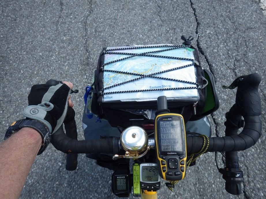
I want a GPS that I can use for backpacking, canoeing, kayaking, and cycling. Thus, want AA batteries. And I tour on bikes with dynohubs that have USB chargers, so wanted a GPS that I could recharge the batteries in it while rolling. Garmin makes a proprietary battery pack that can be recharged by USB in some GPS units that otherwise take two AA batteries. And there are several sources of maps on the internet that can be loaded into Garmins. Very happy with Garmin 64. And I use a tether in case I did not quite get it into the mount right so if it slips out, stays on the bike.
11-26-19, 01:14 PM
#9
Senior Member
Join Date: Mar 2010
Location: Seattle, WA
Posts: 23,208
Mentioned: 89 Post(s)
Tagged: 0 Thread(s)
Quoted: 18883 Post(s)
Liked 10,646 Times
in
6,054 Posts
I use a GPS watch. It's a Garmin and it's been rock solid. Talks to my power meter, also useful skiing, hiking, and swimming. Bluetooth is reliable 100% of the time. Weird their bike division can't seem to get it right, based on all the complaints in here.
11-26-19, 02:29 PM
#10
Senior Member
Thread Starter
I want a GPS that I can use for backpacking, canoeing, kayaking, and cycling. Thus, want AA batteries. And I tour on bikes with dynohubs that have USB chargers, so wanted a GPS that I could recharge the batteries in it while rolling. Garmin makes a proprietary battery pack that can be recharged by USB in some GPS units that otherwise take two AA batteries. And there are several sources of maps on the internet that can be loaded into Garmins. Very happy with Garmin 64. And I use a tether in case I did not quite get it into the mount right so if it slips out, stays on the bike.

What's the bubble level for? Measuring inclines? You definitely don't have a weight weenie case
 11-26-19, 03:04 PM
#11
Too slow
My Garmin 810 has a little over 8 hours of battery life when paired with: speed sensor, heart rate monitor, cadence sensor, lights sensor & radar. Lots of data.

I really like how the radar displays vehicles coming from behind, even on curves!
For more battery life use a couple of rechargeable Panasonic 18650 3400mAh batteries in a USB power bank with cable. 6800mAh compared to the Edge battery rated at 1100mAh? You do the math.
I really like how the radar displays vehicles coming from behind, even on curves!
For more battery life use a couple of rechargeable Panasonic 18650 3400mAh batteries in a USB power bank with cable. 6800mAh compared to the Edge battery rated at 1100mAh? You do the math.
Last edited by 44.5mph; 11-26-19 at 05:08 PM.
11-27-19, 08:04 AM
#13

Senior Member

Join Date: Jun 2011
Location: Tampa, Florida
Posts: 5,585
Bikes: 2017 Colnago C-RS, 2012 Colnago Ace, 2010 Giant Cypress hybrid
Mentioned: 3 Post(s)
Tagged: 0 Thread(s)
Quoted: 408 Post(s)
Liked 122 Times
in
85 Posts
I do a ride across my state every year. It's an organized ride and covers 220 miles. It's two and a half days (60, 80 and 80 miles, respectfully) and because of the different levels of riders, takes us an average of 10 hours to complete the 80 mile days. That is total time which includes lunch an several rest stops along the way. I have a Wahoo Bolt that is paired with a Wahoo Tickr, Wahoo Speed and Cadence sensors and a radar. With all the sensors connected, I get a complete day's ride out of the Bolt without having to use external chargers along the route. My Bolt is over two years old and is used on a daily bases for rides between 40 and 60 miles/ride. BTW, there are several posts on the Google - Wahoo User's Group that tells you how to replace a battery on a Bolt; so the batteries must be available somewhere.
__________________
HCFR Cycling Team
Ride Safe ... Ride Hard ... Ride Daily
2017 Colnago C-RS
2012 Colnago Ace
2010 Giant Cypress
HCFR Cycling Team
Ride Safe ... Ride Hard ... Ride Daily
2017 Colnago C-RS
2012 Colnago Ace
2010 Giant Cypress
11-27-19, 02:12 PM
#14
Senior Member
Join Date: Aug 2010
Location: Madison, WI
Posts: 11,203
Bikes: 1961 Ideor, 1966 Perfekt 3 Speed AB Hub, 1994 Bridgestone MB-6, 2006 Airnimal Joey, 2009 Thorn Sherpa, 2013 Thorn Nomad MkII, 2015 VO Pass Hunter, 2017 Lynskey Backroad, 2017 Raleigh Gran Prix, 1980s Bianchi Mixte on a trainer. Others are now gone.
Mentioned: 48 Post(s)
Tagged: 0 Thread(s)
Quoted: 3459 Post(s)
Liked 1,465 Times
in
1,143 Posts

