


Duchess Rail Trail ride today
 10-27-13, 06:27 PM
#1
Senior Member
Thread Starter
Join Date: Jul 2007
Location: South shore, L.I., NY
Posts: 6,872
Bikes: Flyxii FR322, Cannondale Topstone, Miyata City Liner, Specialized Chisel, Specialized Epic Evo
Mentioned: 18 Post(s)
Tagged: 0 Thread(s)
Quoted: 3231 Post(s)
Liked 2,079 Times
in
1,177 Posts
Duchess Rail Trail ride today
Ah !, finally made the trip up from LI. Joined by a Westchester buddy, rode from the southern terminus in Hopewell Junction to a bit past the Walkway over the Hudson Bridge and into Orange County.
Great trail. About as flat a RT as you can find, certainly less elevation gained/loss then the North County or Harlem Valley RT up in Amenia
Total distance from HJ to the bridge is 13.5 miles one-way. The bridge adds about another 1.3 miles, then of course you can continue into Orange County another 4. We started as BTW, at the parking lot and depot off Railroad Ave., itself off Rt 376, just north of Rt 82. Easy to find, it's on Google Maps. There are also quite a few parking area's between HJ and the bridge, just look on Google maps - Satellite view for a shorter route.
Three things struck me:
1) There were a huge number of users out on a chilly Sunday. There was a stiff north wind and 55 deg. temps, and as it clouded over seemed colder, yet there were ton's of families, walkers, dogs, and a lot of cyclists. The trail is obviously getting used and that's just wonderful. There are many road crossings and at EVERY one, the motorists stopped to let us go. Just wonderful courtesy.
2) The county put a huge amount of money into this path. The signage is first class, with mileage markers every 1/2 mile starting in HJ. Benches and informative signs everywhere, almost too many to stop and read them all !. The highway crossings, especially over Rt 55 is just well done and obviously they put a lot of time and effort in getting this all correct. As well as money.
3) The Walkway over the Hudson is very much that - a walkway. As such and as a cyclist you need to be prepared for hordes of pedestrians. And children unattended. And dogs on the extreme end of their retractable leashes. And of course the errant 16 year old female texting on her phone and paying absolutely no attention to the surroundings. You can ride it but be prepared to stop often and to move slowly and to be patient. This is emphatically not the route for a roadie trying to get in their fast 50 miler. OTOH, the views are amazing, even if it's a huge and sudden change from the calm and relatively empty miles on the bike path. But it's worth every inch, somewhat like riding over the Golden Gate it's ultimately worth the trip up from Hope
Will try to add more photo's later, the site is limiting me to 2.

 well Junction.
Great trail. About as flat a RT as you can find, certainly less elevation gained/loss then the North County or Harlem Valley RT up in Amenia
Total distance from HJ to the bridge is 13.5 miles one-way. The bridge adds about another 1.3 miles, then of course you can continue into Orange County another 4. We started as BTW, at the parking lot and depot off Railroad Ave., itself off Rt 376, just north of Rt 82. Easy to find, it's on Google Maps. There are also quite a few parking area's between HJ and the bridge, just look on Google maps - Satellite view for a shorter route.
Three things struck me:
1) There were a huge number of users out on a chilly Sunday. There was a stiff north wind and 55 deg. temps, and as it clouded over seemed colder, yet there were ton's of families, walkers, dogs, and a lot of cyclists. The trail is obviously getting used and that's just wonderful. There are many road crossings and at EVERY one, the motorists stopped to let us go. Just wonderful courtesy.
2) The county put a huge amount of money into this path. The signage is first class, with mileage markers every 1/2 mile starting in HJ. Benches and informative signs everywhere, almost too many to stop and read them all !. The highway crossings, especially over Rt 55 is just well done and obviously they put a lot of time and effort in getting this all correct. As well as money.
3) The Walkway over the Hudson is very much that - a walkway. As such and as a cyclist you need to be prepared for hordes of pedestrians. And children unattended. And dogs on the extreme end of their retractable leashes. And of course the errant 16 year old female texting on her phone and paying absolutely no attention to the surroundings. You can ride it but be prepared to stop often and to move slowly and to be patient. This is emphatically not the route for a roadie trying to get in their fast 50 miler. OTOH, the views are amazing, even if it's a huge and sudden change from the calm and relatively empty miles on the bike path. But it's worth every inch, somewhat like riding over the Golden Gate it's ultimately worth the trip up from Hope
Will try to add more photo's later, the site is limiting me to 2.
Last edited by Steve B.; 10-28-13 at 01:48 PM.

Likes For Steve B.:
10-29-13, 02:13 AM
#2
Senior Member
Join Date: Aug 2007
Posts: 134
Mentioned: 0 Post(s)
Tagged: 0 Thread(s)
Quoted: 0 Post(s)
Likes: 0
Liked 0 Times
in
0 Posts
The trail is terrific - glad you enjoyed it.
People are out and about on that trail even in the dead of winter - skiers, walkers, runners, even the occasional fat-tired bike.
The trail systems across the river are growing quickly as well. Eventually, the Walkway will connect with New Paltz and beyond.
People are out and about on that trail even in the dead of winter - skiers, walkers, runners, even the occasional fat-tired bike.
The trail systems across the river are growing quickly as well. Eventually, the Walkway will connect with New Paltz and beyond.
10-29-13, 05:55 AM
#3
Senior Member
Thread Starter
Join Date: Jul 2007
Location: South shore, L.I., NY
Posts: 6,872
Bikes: Flyxii FR322, Cannondale Topstone, Miyata City Liner, Specialized Chisel, Specialized Epic Evo
Mentioned: 18 Post(s)
Tagged: 0 Thread(s)
Quoted: 3231 Post(s)
Liked 2,079 Times
in
1,177 Posts
Google map shows that the Maybrook line - Hudson Valley Rail Trail, heads south and is just east of the rail trail that in dribs and drabs runs from Walden to New Paltz and eventually to Kingston. Hopefully they can find an easy point to link the two trails, right now it's a 4 mile road connection on Rt 200, not awful and doable.
Last edited by Steve B.; 10-30-13 at 11:56 AM.
10-29-13, 10:43 PM
#4
Senior Member
Join Date: Aug 2007
Posts: 134
Mentioned: 0 Post(s)
Tagged: 0 Thread(s)
Quoted: 0 Post(s)
Likes: 0
Liked 0 Times
in
0 Posts
The Harlem Rail Trail is on the east side of Dutchess County. It runs from the Wassiac Station at the top of the Harlem Valley MetroNorth line to Millerton Station. (~10.5 miles).
There's an eight mile section of undeveloped rail bed that runs from Millerton to Mountain Road - at Mountain Road, the trail is paved again for four miles to the state park at Copake Falls. (It's an easy road ride to go from one section of the trail to the other.) There's another 24 miles of undeveloped trail from Copake to Chatham, NY. Ultimately, that could be a 46-mile rail trail!
Progress on that trail has been slow - the new county exec has made it more of a priority and money has been allocated to design 11 additional miles of trail.
The Wallkill Valley Rail Trail, as of September, now runs 24 miles from Gardiner to Kingston. (Google the Rosendale Trestle - it's spectacular.) Not really a trail for 23mm tires though...lots of crushed rock.
Eventually, the Hudson Valley Rail Trail, (the trail on the west side of the Walkway), will be extended an extra mile to 299. After that, the plan is to find a way to connect the Wallkill trail to the Hudson Valley trail and, by extension, the Dutchess trail.
10-30-13, 11:53 AM
#5
Senior Member
Thread Starter
Join Date: Jul 2007
Location: South shore, L.I., NY
Posts: 6,872
Bikes: Flyxii FR322, Cannondale Topstone, Miyata City Liner, Specialized Chisel, Specialized Epic Evo
Mentioned: 18 Post(s)
Tagged: 0 Thread(s)
Quoted: 3231 Post(s)
Liked 2,079 Times
in
1,177 Posts
The Harlem Rail Trail is on the east side of Dutchess County. It runs from the Wassiac Station at the top of the Harlem Valley MetroNorth line to Millerton Station. (~10.5 miles).
There's an eight mile section of undeveloped rail bed that runs from Millerton to Mountain Road - at Mountain Road, the trail is paved again for four miles to the state park at Copake Falls. (It's an easy road ride to go from one section of the trail to the other.) There's another 24 miles of undeveloped trail from Copake to Chatham, NY. Ultimately, that could be a 46-mile rail trail!
Progress on that trail has been slow - the new county exec has made it more of a priority and money has been allocated to design 11 additional miles of trail.
The Wallkill Valley Rail Trail, as of September, now runs 24 miles from Gardiner to Kingston. (Google the Rosendale Trestle - it's spectacular.) Not really a trail for 23mm tires though...lots of crushed rock.
Eventually, the Hudson Valley Rail Trail, (the trail on the west side of the Walkway), will be extended an extra mile to 299. After that, the plan is to find a way to connect the Wallkill trail to the Hudson Valley trail and, by extension, the Dutchess trail.
There's an eight mile section of undeveloped rail bed that runs from Millerton to Mountain Road - at Mountain Road, the trail is paved again for four miles to the state park at Copake Falls. (It's an easy road ride to go from one section of the trail to the other.) There's another 24 miles of undeveloped trail from Copake to Chatham, NY. Ultimately, that could be a 46-mile rail trail!
Progress on that trail has been slow - the new county exec has made it more of a priority and money has been allocated to design 11 additional miles of trail.
The Wallkill Valley Rail Trail, as of September, now runs 24 miles from Gardiner to Kingston. (Google the Rosendale Trestle - it's spectacular.) Not really a trail for 23mm tires though...lots of crushed rock.
Eventually, the Hudson Valley Rail Trail, (the trail on the west side of the Walkway), will be extended an extra mile to 299. After that, the plan is to find a way to connect the Wallkill trail to the Hudson Valley trail and, by extension, the Dutchess trail.
Thanks for the correction.
Also glad to hear about the Walkill trail finished north to Kingston, I know it's also a gravel trail from Walkill down to Walden, but I don't think there's plans to head any further south due to Conrail still using the live south of Walden.
Last edited by Steve B.; 10-30-13 at 12:00 PM.
11-03-13, 02:50 PM
#6

aka Tom Reingold

Join Date: Jan 2009
Location: New York, NY, and High Falls, NY, USA
Posts: 40,502
Bikes: 1962 Rudge Sports, 1971 Raleigh Super Course, 1971 Raleigh Pro Track, 1974 Raleigh International, 1975 Viscount Fixie, 1982 McLean, 1996 Lemond (Ti), 2002 Burley Zydeco tandem
Mentioned: 511 Post(s)
Tagged: 0 Thread(s)
Quoted: 7348 Post(s)
Liked 2,461 Times
in
1,433 Posts
My wife and I and some friends took this trail a few weeks ago. It's really nice. There are lots of people using it, all in great moods, happy to have this now. We stopped in the middle of the bridge and went back to Hopewell Junction.
__________________
Tom Reingold, tom@noglider.com
New York City and High Falls, NY
Blogs: The Experienced Cyclist; noglider's ride blog
�When man invented the bicycle he reached the peak of his attainments.� � Elizabeth West, US author
Please email me rather than PM'ing me. Thanks.
Tom Reingold, tom@noglider.com
New York City and High Falls, NY
Blogs: The Experienced Cyclist; noglider's ride blog
�When man invented the bicycle he reached the peak of his attainments.� � Elizabeth West, US author
Please email me rather than PM'ing me. Thanks.
04-21-19, 07:34 PM
#7
Senior Member

Join Date: May 2017
Location: Northampton, MA
Posts: 1,909
Bikes: 36" Unicycle, winter knock-around hybrid bike
Mentioned: 15 Post(s)
Tagged: 0 Thread(s)
Quoted: 930 Post(s)
Liked 393 Times
in
282 Posts
Took the train up to Poughkeepsie and did the Duchess County Rail trail today - and I have to say, it's in by far the best condition of any path I've ridden on. Extremely smooth, only one section where you can just detect a hint of the beginning of frost heaves, but only there and still only scarcely noticeable - overall the nicest riding I've experienced.
Nice signage, too, though the cumulative mile markers seem only to be visible when you're riding from the Hopwell Junction end towards Poughkeepsie. Bathroom at Hopewell was clean (though a sink would be nice) and vending machine worked, which added a welcome powerade to a fluids mix tuned for a more overcast day than it turned out.

Hopewell Junction, end of the Duchess County trail, 13 miles from Poughkeepsie
Then it was back to Poughkeepsie and cautiously across the Walkway Over the Hudson. Having been predicted to be a cloudy day and still not peak season that wasn't yet too crowded with folks on foot for riding slowly and courteously to work.
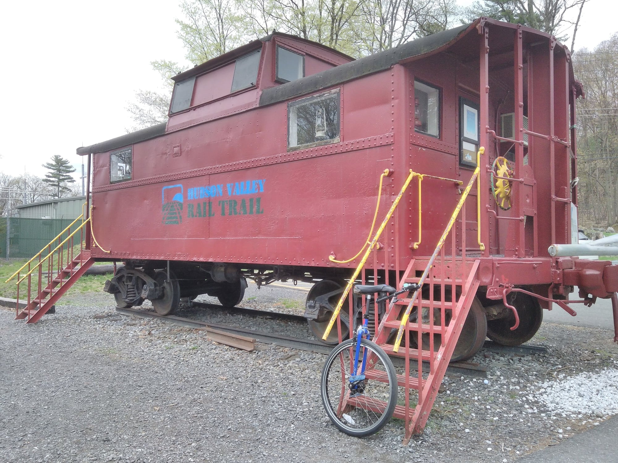
Start of the Hudson Valley Rail Trail on the west side of the river (trail itself is paved, gravel is just around this decoration)
By then I was feeling less on top of my game, and the train schedule I'd initially consulted showed a near 2-hour gap (turns out there were infill trains to Penn Station instead of Grand Central with only Amtrak scheduled in between) so I turned around a couple of miles out and headed back. There's a nice park rest area at the west side of the bridge - sinks, bottle filling station, etc.
Definitely recommended - the Duchess County path in particular for great conditions and low-stress riding. With the great surface it seems popular with casual recumbent riders (never seen so many in one ride) and even saw a family in a quadracycle pedal surrey. A round trip to the ends on both sides of the river would be about 35 miles, or a nice 50k if you cut it a few short as I did today.
Three pieces of advice:
1) The shoreline elevator up to the walkway is seasonal and currently closed for maintenance, check before heading up that way, otherwise it's a bit over a mile on quiet village streets gently uphill to the more eastern entrance. There are signs showing the way.
2) If traveling from NYC consult a schedule that shows both Grand Central and Penn Station trains; returning to the less convenient of the two still beats waiting an extra hour. Nope, those are Amtrak so they presumably charge more and don't take bikes. Hudson line really wants you to bring bungee cords to secure bikes.
3) Pizza place at the corner of the west parking lot in Poughkeepsie has huge slices for $4, just right for the train ride home
Theoretically Metro North is on the hook to extend the Hopewell end southeast (hah!) to Brewster as the Maybrook trail, at which point it will be within a mile or so of connecting with the Putnam trail coming up from the Bronx.
Nice signage, too, though the cumulative mile markers seem only to be visible when you're riding from the Hopwell Junction end towards Poughkeepsie. Bathroom at Hopewell was clean (though a sink would be nice) and vending machine worked, which added a welcome powerade to a fluids mix tuned for a more overcast day than it turned out.
Hopewell Junction, end of the Duchess County trail, 13 miles from Poughkeepsie
Then it was back to Poughkeepsie and cautiously across the Walkway Over the Hudson. Having been predicted to be a cloudy day and still not peak season that wasn't yet too crowded with folks on foot for riding slowly and courteously to work.
Start of the Hudson Valley Rail Trail on the west side of the river (trail itself is paved, gravel is just around this decoration)
By then I was feeling less on top of my game, and the train schedule I'd initially consulted showed a near 2-hour gap (
Definitely recommended - the Duchess County path in particular for great conditions and low-stress riding. With the great surface it seems popular with casual recumbent riders (never seen so many in one ride) and even saw a family in a quadracycle pedal surrey. A round trip to the ends on both sides of the river would be about 35 miles, or a nice 50k if you cut it a few short as I did today.
Three pieces of advice:
1) The shoreline elevator up to the walkway is seasonal and currently closed for maintenance, check before heading up that way, otherwise it's a bit over a mile on quiet village streets gently uphill to the more eastern entrance. There are signs showing the way.
3) Pizza place at the corner of the west parking lot in Poughkeepsie has huge slices for $4, just right for the train ride home
Theoretically Metro North is on the hook to extend the Hopewell end southeast (hah!) to Brewster as the Maybrook trail, at which point it will be within a mile or so of connecting with the Putnam trail coming up from the Bronx.
Last edited by UniChris; 04-23-19 at 01:13 PM.
04-23-19, 04:12 AM
#8
Senior Member

I've done that ride a few times and love it. Park in Hopewell Junction ride up to and over the Walkway and back. Nice 30 mile day.
Both ends of that trail are nice.
Both ends of that trail are nice.
04-23-19, 11:23 AM
#9
Senior Member
Join Date: May 2017
Location: Northampton, MA
Posts: 1,909
Bikes: 36" Unicycle, winter knock-around hybrid bike
Mentioned: 15 Post(s)
Tagged: 0 Thread(s)
Quoted: 930 Post(s)
Liked 393 Times
in
282 Posts
A uni-friend wants to head up there but only for a shorter ride, may do the walkway and explore to the west extension then do Hopewell and back on my own in the afternoon to make the two hour train ride feel justified. Wish the trains were more often than every two hours though!
04-23-19, 12:30 PM
#10
Senior Member
Join Date: Jul 2008
Location: 25 miles northwest of Boston
Posts: 29,549
Bikes: Bottecchia Sprint, GT Timberline 29r, Marin Muirwoods 29er, Trek FX Alpha 7.0
Mentioned: 112 Post(s)
Tagged: 0 Thread(s)
Quoted: 5224 Post(s)
Liked 3,581 Times
in
2,342 Posts
I've got family in that area I should tell them about this trail
04-23-19, 02:16 PM
#11
aka Tom Reingold
Join Date: Jan 2009
Location: New York, NY, and High Falls, NY, USA
Posts: 40,502
Bikes: 1962 Rudge Sports, 1971 Raleigh Super Course, 1971 Raleigh Pro Track, 1974 Raleigh International, 1975 Viscount Fixie, 1982 McLean, 1996 Lemond (Ti), 2002 Burley Zydeco tandem
Mentioned: 511 Post(s)
Tagged: 0 Thread(s)
Quoted: 7348 Post(s)
Liked 2,461 Times
in
1,433 Posts
They don't know about it? That's crazy. 
A year or two ago, my wife took our tandem and met another tandeming couple, and we did the whole trail, out and back. It was the longest the two of us had ever ridden our tandem, 36 miles round trip. It's a good thing the trail is flat, as that makes it easier.
I've been on it a few times now. Very nice.
I'm surprised there will be rail trails from Poughkeepsie to the Bronx. I did rode from High Falls to Yonkers a few summers ago, taking the Hudson Valley Rail Trail to Hopewell Junction, and I didn't find a non-hilly route south of Hopewell Junction. I ended up climbing Hosner Mountain which was difficult.
__________________
Tom Reingold, tom@noglider.com
New York City and High Falls, NY
Blogs: The Experienced Cyclist; noglider's ride blog
�When man invented the bicycle he reached the peak of his attainments.� � Elizabeth West, US author
Please email me rather than PM'ing me. Thanks.
Tom Reingold, tom@noglider.com
New York City and High Falls, NY
Blogs: The Experienced Cyclist; noglider's ride blog
�When man invented the bicycle he reached the peak of his attainments.� � Elizabeth West, US author
Please email me rather than PM'ing me. Thanks.
Likes For noglider:
04-23-19, 02:55 PM
#12
Senior Member
Join Date: May 2017
Location: Northampton, MA
Posts: 1,909
Bikes: 36" Unicycle, winter knock-around hybrid bike
Mentioned: 15 Post(s)
Tagged: 0 Thread(s)
Quoted: 930 Post(s)
Liked 393 Times
in
282 Posts
I'm surprised there will be rail trails from Poughkeepsie to the Bronx. I did rode from High Falls to Yonkers a few summers ago, taking the Hudson Valley Rail Trail to Hopewell Junction, and I didn't find a non-hilly route south of Hopewell Junction. I ended up climbing Hosner Mountain which was difficult.
Unfortunately the published plan doesn't include the grading data that of course exists on some fading railway map somewhere. But it does show the route. https://maybrooktrailway.org/wp-cont...t_20180227.pdf and it seemed like most of it is about a 1% grade.
I didn't really appreciate how flat something like the South County trail actual is until I got a ride back into the city from the north - there are some pretty serious open hillsides in Yonkers those railroad planners threaded between, in a way you don't really get a sense of from the wooded trail.
Ironically one of the few things I didn't like about the Duchess trail was the places it had sharp dips to a road crossing that they built on a curve, in one case a really wild ω of a shape. I'm assuming those where once trestles or embankments removed after the tracks were gone and perpendicular roads were built.
Last edited by UniChris; 04-23-19 at 05:58 PM.
04-23-19, 07:12 PM
#13
Senior Member
Thread Starter
Join Date: Jul 2007
Location: South shore, L.I., NY
Posts: 6,872
Bikes: Flyxii FR322, Cannondale Topstone, Miyata City Liner, Specialized Chisel, Specialized Epic Evo
Mentioned: 18 Post(s)
Tagged: 0 Thread(s)
Quoted: 3231 Post(s)
Liked 2,079 Times
in
1,177 Posts
Not sure there’s a plan to connect the Hudson Valley Rail Trail in Orange County thru New Paltz to the Walkill Trail. The rail bed the HVT uses west from the bridge heads due south from its current western terminus at Tony Williams Park. HVT and Walkill were completely separate rail lines and didn’t connect in the New Paltz area.
Any connection is likely to be on street painted bike lane. It’s currently 5 miles on road thru NP.
But someday, Kingston down to New Paltz on the Walkill. A brief road detour and onto the HVT. Then across the bridge and down the Duchess trail TO BREWSTER. Then the Putnam and Westchester trails to the Bronx.
Or or a bit of a detour north to the Harlem Valley RT and up to damned near Albany. Or maybe east across Conn.
I hope I live to see the day,
04-23-19, 08:27 PM
#14
Senior Member
Join Date: May 2017
Location: Northampton, MA
Posts: 1,909
Bikes: 36" Unicycle, winter knock-around hybrid bike
Mentioned: 15 Post(s)
Tagged: 0 Thread(s)
Quoted: 930 Post(s)
Liked 393 Times
in
282 Posts
Not sure there�s a plan to connect the Hudson Valley Rail Trail in Orange County thru New Paltz to the Walkill Trail. The rail bed the HVT uses west from the bridge heads due south from its current western terminus at Tony Williams Park. HVT and Walkill were completely separate rail lines and didn�t connect in the New Paltz area.
Any connection is likely to be on street painted bike lane. It�s currently 5 miles on road thru NP.
Any connection is likely to be on street painted bike lane. It�s currently 5 miles on road thru NP.
Update on Empire State Trail/HVRT from NYS DOT | New Paltz NY
It does seem like the overall Empire State Trail plan is showing more on-road routing, but that video seems to imply they are building a distinct trail as far as South Street (Lowe's), and possible even as far as the throughway. It has definitely in the last year been extended further west than Tony Williams Park.
And then yes, they're going to go up to Kingston (there's some plan to route around the prison) and then back over the river and further north.
04-23-19, 08:56 PM
#15
Senior Member
Thread Starter
Join Date: Jul 2007
Location: South shore, L.I., NY
Posts: 6,872
Bikes: Flyxii FR322, Cannondale Topstone, Miyata City Liner, Specialized Chisel, Specialized Epic Evo
Mentioned: 18 Post(s)
Tagged: 0 Thread(s)
Quoted: 3231 Post(s)
Liked 2,079 Times
in
1,177 Posts
Hmm, my source of info was an Ulster County video at https://www.youtube.com/watch?v=1F4Tmx-p9Ow and also
Update on Empire State Trail/HVRT from NYS DOT | New Paltz NY
It does seem like the overall Empire State Trail plan is showing more on-road routing, but that video seems to imply they are building a distinct trail as far as South Street (Lowe's), and possible even as far as the throughway. It has definitely in the last year been extended further west than Tony Williams Park.
And then yes, they're going to go up to Kingston (there's some plan to route around the prison) and then back over the river and further north.
04-24-19, 08:19 PM
#16
aka Tom Reingold
Join Date: Jan 2009
Location: New York, NY, and High Falls, NY, USA
Posts: 40,502
Bikes: 1962 Rudge Sports, 1971 Raleigh Super Course, 1971 Raleigh Pro Track, 1974 Raleigh International, 1975 Viscount Fixie, 1982 McLean, 1996 Lemond (Ti), 2002 Burley Zydeco tandem
Mentioned: 511 Post(s)
Tagged: 0 Thread(s)
Quoted: 7348 Post(s)
Liked 2,461 Times
in
1,433 Posts
The ultimate goal is to have a trail from NYC to the Canadian border. This will form a T with the Erie Canal trail that goes from Buffalo to Albany.
__________________
Tom Reingold, tom@noglider.com
New York City and High Falls, NY
Blogs: The Experienced Cyclist; noglider's ride blog
�When man invented the bicycle he reached the peak of his attainments.� � Elizabeth West, US author
Please email me rather than PM'ing me. Thanks.
Tom Reingold, tom@noglider.com
New York City and High Falls, NY
Blogs: The Experienced Cyclist; noglider's ride blog
�When man invented the bicycle he reached the peak of his attainments.� � Elizabeth West, US author
Please email me rather than PM'ing me. Thanks.
04-26-19, 09:48 AM
#17
Senior Member
Join Date: May 2010
Location: Bristol, R. I.
Posts: 4,340
Bikes: Specialized Secteur, old Peugeot
Mentioned: 20 Post(s)
Tagged: 0 Thread(s)
Quoted: 663 Post(s)
Liked 496 Times
in
299 Posts
Ah !, finally made the trip up from LI. Joined by a Westchester buddy, rode from the southern terminus in Hopewell Junction to a bit past the Walkway over the Hudson Bridge and into Orange County.
Great trail. About as flat a RT as you can find, certainly less elevation gained/loss then the North County or Harlem Valley RT up in Amenia
Total distance from HJ to the bridge is 13.5 miles one-way. The bridge adds about another 1.3 miles, then of course you can continue into Orange County another 4. We started as BTW, at the parking lot and depot off Railroad Ave., itself off Rt 376, just north of Rt 82. Easy to find, it's on Google Maps. There are also quite a few parking area's between HJ and the bridge, just look on Google maps - Satellite view for a shorter route.
Three things struck me:
1) There were a huge number of users out on a chilly Sunday. There was a stiff north wind and 55 deg. temps, and as it clouded over seemed colder, yet there were ton's of families, walkers, dogs, and a lot of cyclists. The trail is obviously getting used and that's just wonderful. There are many road crossings and at EVERY one, the motorists stopped to let us go. Just wonderful courtesy.
2) The county put a huge amount of money into this path. The signage is first class, with mileage markers every 1/2 mile starting in HJ. Benches and informative signs everywhere, almost too many to stop and read them all !. The highway crossings, especially over Rt 55 is just well done and obviously they put a lot of time and effort in getting this all correct. As well as money.
3) The Walkway over the Hudson is very much that - a walkway. As such and as a cyclist you need to be prepared for hordes of pedestrians. And children unattended. And dogs on the extreme end of their retractable leashes. And of course the errant 16 year old female texting on her phone and paying absolutely no attention to the surroundings. You can ride it but be prepared to stop often and to move slowly and to be patient. This is emphatically not the route for a roadie trying to get in their fast 50 miler. OTOH, the views are amazing, even if it's a huge and sudden change from the calm and relatively empty miles on the bike path. But it's worth every inch, somewhat like riding over the Golden Gate it's ultimately worth the trip up from Hope
Will try to add more photo's later, the site is limiting me to 2.
well Junction.
Great trail. About as flat a RT as you can find, certainly less elevation gained/loss then the North County or Harlem Valley RT up in Amenia
Total distance from HJ to the bridge is 13.5 miles one-way. The bridge adds about another 1.3 miles, then of course you can continue into Orange County another 4. We started as BTW, at the parking lot and depot off Railroad Ave., itself off Rt 376, just north of Rt 82. Easy to find, it's on Google Maps. There are also quite a few parking area's between HJ and the bridge, just look on Google maps - Satellite view for a shorter route.
Three things struck me:
1) There were a huge number of users out on a chilly Sunday. There was a stiff north wind and 55 deg. temps, and as it clouded over seemed colder, yet there were ton's of families, walkers, dogs, and a lot of cyclists. The trail is obviously getting used and that's just wonderful. There are many road crossings and at EVERY one, the motorists stopped to let us go. Just wonderful courtesy.
2) The county put a huge amount of money into this path. The signage is first class, with mileage markers every 1/2 mile starting in HJ. Benches and informative signs everywhere, almost too many to stop and read them all !. The highway crossings, especially over Rt 55 is just well done and obviously they put a lot of time and effort in getting this all correct. As well as money.
3) The Walkway over the Hudson is very much that - a walkway. As such and as a cyclist you need to be prepared for hordes of pedestrians. And children unattended. And dogs on the extreme end of their retractable leashes. And of course the errant 16 year old female texting on her phone and paying absolutely no attention to the surroundings. You can ride it but be prepared to stop often and to move slowly and to be patient. This is emphatically not the route for a roadie trying to get in their fast 50 miler. OTOH, the views are amazing, even if it's a huge and sudden change from the calm and relatively empty miles on the bike path. But it's worth every inch, somewhat like riding over the Golden Gate it's ultimately worth the trip up from Hope
Will try to add more photo's later, the site is limiting me to 2.
04-26-19, 10:15 AM
#18
Senior Guest
Join Date: Jan 2008
Location: Upstate NY, USA
Posts: 375
Bikes: Jamis Endura, Cannondale CAAD, Raleigh Cross, Fausto Coppi.
Mentioned: 3 Post(s)
Tagged: 0 Thread(s)
Quoted: 80 Post(s)
Liked 47 Times
in
31 Posts
The new trail along route 299 from the Walkway Over the Hudson to New Paltz is already paved although not officially open yet. I already rode it a couple of times. It is very flat and smooth. From New Paltz you can ride to Wallkill or Kingston on the Walkill trail, although it is not paved, but I do ride it a lot on 23 mm tires.
04-26-19, 10:20 AM
#19
Senior Guest
Join Date: Jan 2008
Location: Upstate NY, USA
Posts: 375
Bikes: Jamis Endura, Cannondale CAAD, Raleigh Cross, Fausto Coppi.
Mentioned: 3 Post(s)
Tagged: 0 Thread(s)
Quoted: 80 Post(s)
Liked 47 Times
in
31 Posts
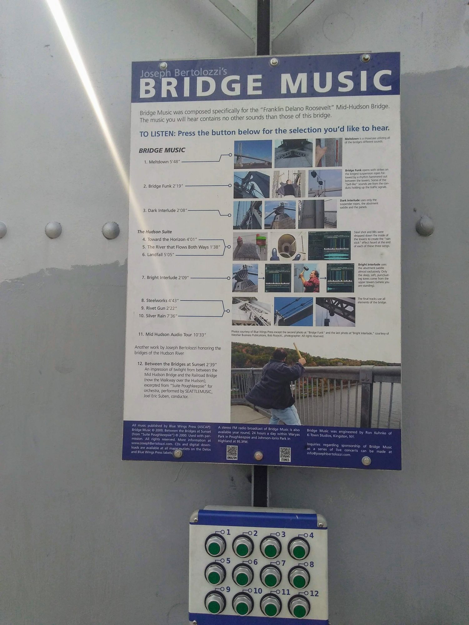
I also prefer riding on the Mid Hudson bridge instead of the Walkway over the Hudson bridge, because there are no people on the Mid Hudson Bridge. The Walkway may be packed with pedestrians on weekends. Also you can listen to the "Bridge Music" on the Mid Hudson Bridge.
Likes For Andrey:

