


Show us your Rail Trails, Hiking Trails, Cycling Paths, etc.
 12-13-19, 11:02 AM
#76

Mad bike riding scientist

Join Date: Nov 2004
Location: Denver, CO
Posts: 27,342
Bikes: Some silver ones, a red one, a black and orange one, and a few titanium ones
Mentioned: 152 Post(s)
Tagged: 1 Thread(s)
Quoted: 6200 Post(s)
Liked 4,203 Times
in
2,358 Posts
Colorado doesn’t have many “railtrails” but we have a lot of trails that used to be rails. There’s even a book on the subject that I have used for the better part of 40 years to plan rides here. I’ve mountain biked them a lot but in the last few years I’ve been using them for bikepacking trips. I did this one about 3 years ago but lost my camera along the route and have no pictures of it. Shame because it’s a great ride!
I did a loop last year that used Gold Camp Road (Colorado Springs & Cripple Creek District Railway), Phantom Canyon (Florence and Cripple Creek Railroad) and Shelf Road (Cripple Creek Stage Road). Gold Camp and Phantom Canyon are open to cars (mostly) but they are still railroad beds. And both are spectacular.
Gold Camp has 7 tunnels along it’s length (about 40 miles). Tunnel 3, aka Helen Hunt Tunnel because it goes under Helen Hunt Falls, is collapsed and closed but a trail around the tunnel has been put in place for bikes and pedestrians. That results in about 5 miles of car free travel.
 DSCN1088 by Stuart Black, on Flickr
The railroad clings to the steep Colorado Springs mountains
 DSCN1104 by Stuart Black, on Flickr
Cathedral Park Spires
 DSCN1107 by Stuart Black, on Flickr
Outside of Cripple Creek, Phantom Canyon Road steeply descends to Ca�on City. The railroad operated from the 1880s to 1912 when it was closed in a single night during a flash flood that ripped out 15 or 17 bridges.
 DSCN1138 by Stuart Black, on Flickr
 DSCN1154 by Stuart Black, on Flickr
The only bridge to survive the flash flood
 DSCN1158 by Stuart Black, on Flickr
The canyon narrows to almost a slot in places
 DSCN1163 by Stuart Black, on Flickr
The return route to Cripple Creek is via Shelf Road which is a stage road which is much steeper and rougher with 18% grades in places
 DSCN1234 by Stuart Black, on Flickr
Window Rock
 DSCN1239 by Stuart Black, on Flickr
 DSCN1245 by Stuart Black, on Flickr
The return to Colorado Springs is a fantastic 25 mph average 40 mile downhill.
I did a loop last year that used Gold Camp Road (Colorado Springs & Cripple Creek District Railway), Phantom Canyon (Florence and Cripple Creek Railroad) and Shelf Road (Cripple Creek Stage Road). Gold Camp and Phantom Canyon are open to cars (mostly) but they are still railroad beds. And both are spectacular.
Gold Camp has 7 tunnels along it’s length (about 40 miles). Tunnel 3, aka Helen Hunt Tunnel because it goes under Helen Hunt Falls, is collapsed and closed but a trail around the tunnel has been put in place for bikes and pedestrians. That results in about 5 miles of car free travel.
DSCN1088 by Stuart Black, on FlickrThe railroad clings to the steep Colorado Springs mountains
DSCN1104 by Stuart Black, on FlickrCathedral Park Spires
DSCN1107 by Stuart Black, on FlickrOutside of Cripple Creek, Phantom Canyon Road steeply descends to Ca�on City. The railroad operated from the 1880s to 1912 when it was closed in a single night during a flash flood that ripped out 15 or 17 bridges.
DSCN1138 by Stuart Black, on FlickrDSCN1154 by Stuart Black, on FlickrThe only bridge to survive the flash flood
DSCN1158 by Stuart Black, on FlickrThe canyon narrows to almost a slot in places
DSCN1163 by Stuart Black, on FlickrThe return route to Cripple Creek is via Shelf Road which is a stage road which is much steeper and rougher with 18% grades in places
DSCN1234 by Stuart Black, on FlickrWindow Rock
DSCN1239 by Stuart Black, on FlickrDSCN1245 by Stuart Black, on FlickrThe return to Colorado Springs is a fantastic 25 mph average 40 mile downhill.
__________________
Stuart Black
Plan Epsilon Around Lake Michigan in the era of Covid
Old School�When It Wasn�t Ancient bikepacking
Gold Fever Three days of dirt in Colorado
Pokin' around the Poconos A cold ride around Lake Erie
Dinosaurs in Colorado A mountain bike guide to the Purgatory Canyon dinosaur trackway
Solo Without Pie. The search for pie in the Midwest.
Picking the Scablands. Washington and Oregon, 2005. Pie and spiders on the Columbia River!

Likes For cyccommute:
12-13-19, 11:53 AM
#77
Senior Member
Join Date: Jan 2010
Posts: 39,217
Mentioned: 211 Post(s)
Tagged: 1 Thread(s)
Quoted: 18397 Post(s)
Liked 15,494 Times
in
7,317 Posts
Interesting. That happened to one of the many tunnels of the Route of Hiawatha Trail. It was under a fault which eventually caused it to collapse after the railroad was abandoned in 1980. They had to construct a bypass to complete the trail.
 12-13-19, 12:01 PM
#78
Senior Member
Join Date: Jan 2010
Posts: 39,217
Mentioned: 211 Post(s)
Tagged: 1 Thread(s)
Quoted: 18397 Post(s)
Liked 15,494 Times
in
7,317 Posts
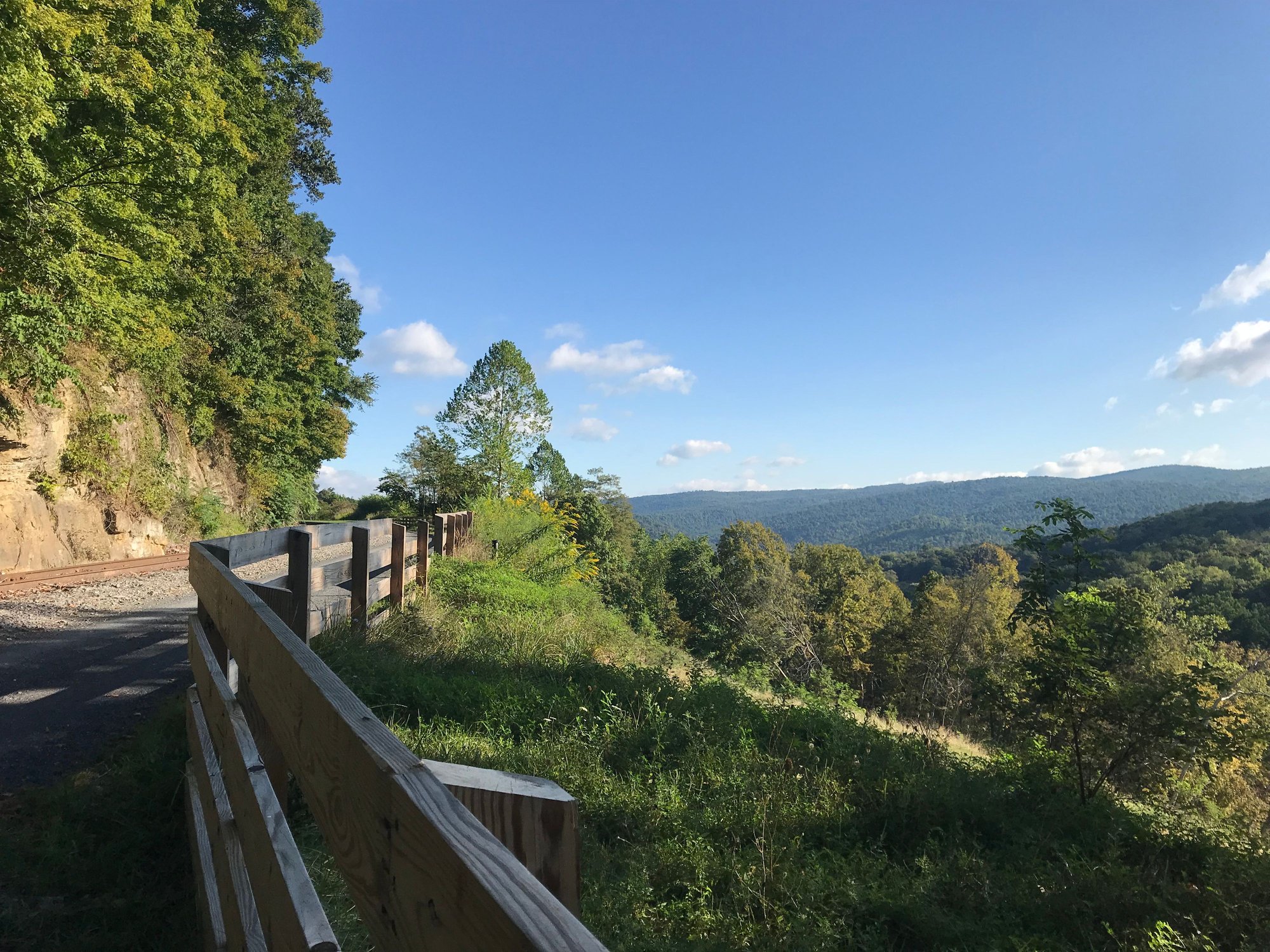
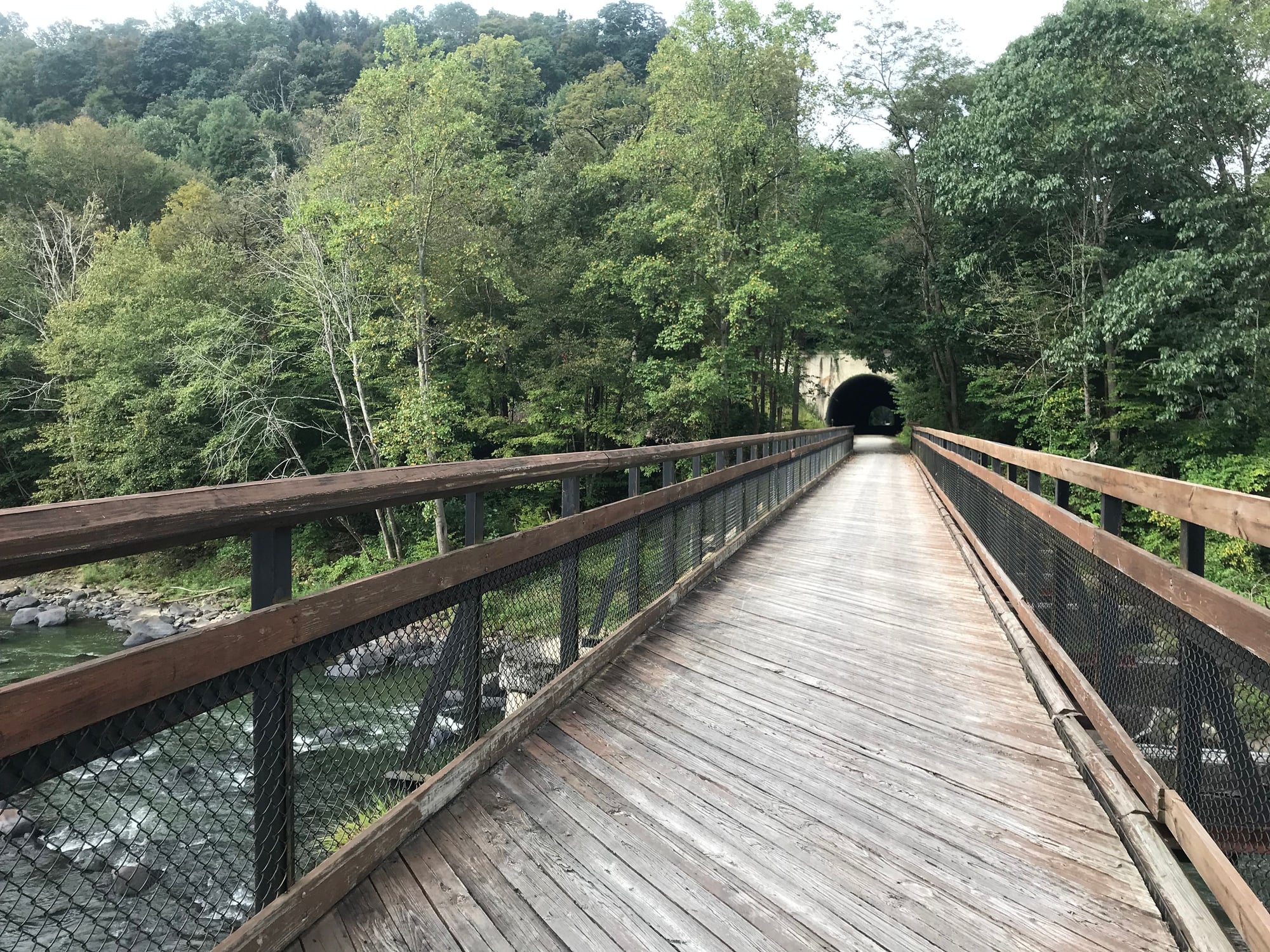
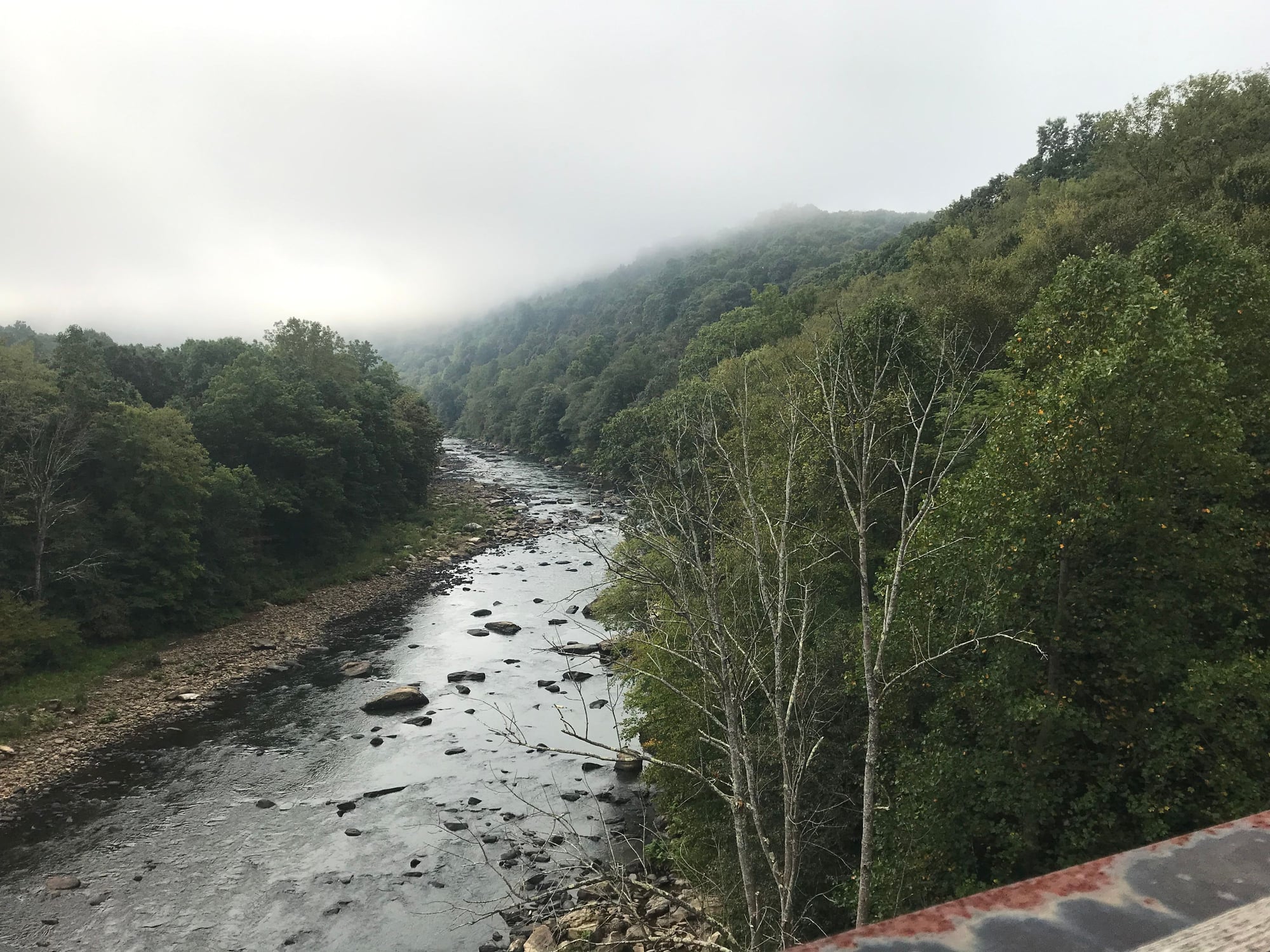
Images from my September trip up and back on the GAP.

12-13-19, 01:36 PM
#79
Newbie
Join Date: Mar 2019
Location: St. Louis, MO
Posts: 30
Bikes: 2019 Gravity Avenue A, 1993 Specialized Hardrock Sport, 1983 Trek 520
Mentioned: 0 Post(s)
Tagged: 0 Thread(s)
Quoted: 8 Post(s)
Likes: 0
Liked 21 Times
in
12 Posts
Love all the pics! 
Still too new to post my own.
Still too new to post my own.
12-13-19, 02:16 PM
#80
Senior Member
Join Date: Jul 2008
Location: 25 miles northwest of Boston
Posts: 29,546
Bikes: Bottecchia Sprint, GT Timberline 29r, Marin Muirwoods 29er, Trek FX Alpha 7.0
Mentioned: 112 Post(s)
Tagged: 0 Thread(s)
Quoted: 5223 Post(s)
Liked 3,579 Times
in
2,341 Posts
12-13-19, 02:24 PM
#81
Senior Member
Join Date: Jul 2008
Location: 25 miles northwest of Boston
Posts: 29,546
Bikes: Bottecchia Sprint, GT Timberline 29r, Marin Muirwoods 29er, Trek FX Alpha 7.0
Mentioned: 112 Post(s)
Tagged: 0 Thread(s)
Quoted: 5223 Post(s)
Liked 3,579 Times
in
2,341 Posts
Colorado doesn�t have many �railtrails� but we have a lot of trails that used to be rails. There�s even a book on the subject that I have used for the better part of 40 years to plan rides here. I�ve mountain biked them a lot but in the last few years I�ve been using them for bikepacking trips
12-13-19, 02:39 PM
#82
Mad bike riding scientist
Join Date: Nov 2004
Location: Denver, CO
Posts: 27,342
Bikes: Some silver ones, a red one, a black and orange one, and a few titanium ones
Mentioned: 152 Post(s)
Tagged: 1 Thread(s)
Quoted: 6200 Post(s)
Liked 4,203 Times
in
2,358 Posts
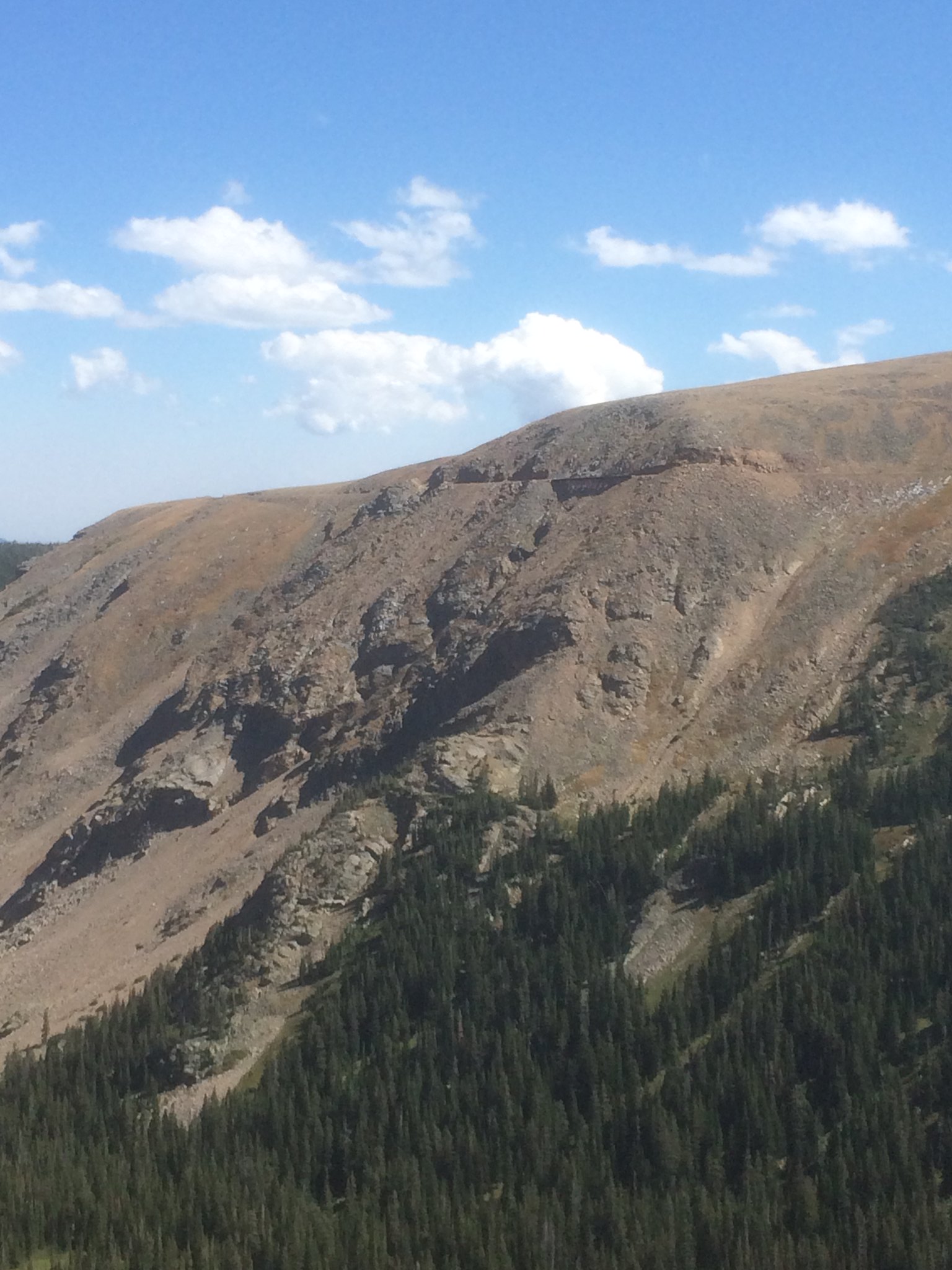
Climate also plays a large role as well. The high mountains go through a yearly large temperature fluctuations from warm enough to melt water during the day and freeze water at night. As the water freezes, it expands and splits rocks. �Frost heaving� is something that happens often and can cause massive movement of rock. We just had a frost heave event that brought down tons of material onto I70 and closed it for two days on Thanksgiving weekend. Tunnels take a beating at their entrances. I suspect that occurred in Idaho as well.
We have several tunnels here that are very long...the Alpine Tunnel is 1.5 miles long at 11,000 feet and was the highest tunnel in the work for a long time...but the entrances are generally collapsed because of the altitude.
__________________
Stuart Black
Plan Epsilon Around Lake Michigan in the era of Covid
Old School�When It Wasn�t Ancient bikepacking
Gold Fever Three days of dirt in Colorado
Pokin' around the Poconos A cold ride around Lake Erie
Dinosaurs in Colorado A mountain bike guide to the Purgatory Canyon dinosaur trackway
Solo Without Pie. The search for pie in the Midwest.
Picking the Scablands. Washington and Oregon, 2005. Pie and spiders on the Columbia River!
Stuart Black
Plan Epsilon Around Lake Michigan in the era of Covid
Old School�When It Wasn�t Ancient bikepacking
Gold Fever Three days of dirt in Colorado
Pokin' around the Poconos A cold ride around Lake Erie
Dinosaurs in Colorado A mountain bike guide to the Purgatory Canyon dinosaur trackway
Solo Without Pie. The search for pie in the Midwest.
Picking the Scablands. Washington and Oregon, 2005. Pie and spiders on the Columbia River!
12-13-19, 02:40 PM
#83
Mad bike riding scientist
Join Date: Nov 2004
Location: Denver, CO
Posts: 27,342
Bikes: Some silver ones, a red one, a black and orange one, and a few titanium ones
Mentioned: 152 Post(s)
Tagged: 1 Thread(s)
Quoted: 6200 Post(s)
Liked 4,203 Times
in
2,358 Posts
__________________
Stuart Black
Plan Epsilon Around Lake Michigan in the era of Covid
Old School�When It Wasn�t Ancient bikepacking
Gold Fever Three days of dirt in Colorado
Pokin' around the Poconos A cold ride around Lake Erie
Dinosaurs in Colorado A mountain bike guide to the Purgatory Canyon dinosaur trackway
Solo Without Pie. The search for pie in the Midwest.
Picking the Scablands. Washington and Oregon, 2005. Pie and spiders on the Columbia River!
Stuart Black
Plan Epsilon Around Lake Michigan in the era of Covid
Old School�When It Wasn�t Ancient bikepacking
Gold Fever Three days of dirt in Colorado
Pokin' around the Poconos A cold ride around Lake Erie
Dinosaurs in Colorado A mountain bike guide to the Purgatory Canyon dinosaur trackway
Solo Without Pie. The search for pie in the Midwest.
Picking the Scablands. Washington and Oregon, 2005. Pie and spiders on the Columbia River!
12-13-19, 04:48 PM
#86
Senior Member
Join Date: Jan 2010
Posts: 39,217
Mentioned: 211 Post(s)
Tagged: 1 Thread(s)
Quoted: 18397 Post(s)
Liked 15,494 Times
in
7,317 Posts
12-13-19, 08:27 PM
#87
Mad bike riding scientist
Join Date: Nov 2004
Location: Denver, CO
Posts: 27,342
Bikes: Some silver ones, a red one, a black and orange one, and a few titanium ones
Mentioned: 152 Post(s)
Tagged: 1 Thread(s)
Quoted: 6200 Post(s)
Liked 4,203 Times
in
2,358 Posts
More Colorado trails that were rails:
Rollins Pass. I have a long history with Rollins Pass. I’ve been over it in a car a few times since 1974. I even did it in a company truck loaded with plumbing supplies with my girlfriend (now wife of many years). I’d probably have been fired if the bosses ever knew. My bicycle adventures with Rollins Pass started around 1984 when I got my first mountain bike.
Rollins Pass was originally built to provide service from Denver to Salt Lake City (never got there). It’s one of the highest...if not the highest railroad passes... in the US. It goes up to 11600 feet. Although it was an “all weather road”, it was a very difficult all weather road with some trains being stuck on the top for weeks due to storms. Eventually, the 30 miles of nightmarish railroad was replaced by a 6 mile tunnel. The road was closed in the early 1900s and the trackway converted to a road in the 1930s.
The trip from the east portal of the Moffat Tunnel to the west portal is just about the distance of a metric century and that’s what I used to do for my local touring club. I would start at the east portal and ride up and over and back in a single day. I had a series of rides to work up to a dirt century.
Weather on the pass is always iffy and snow fields up until August aren’t unheard of. I even did my first off-road tour over Rollins Pass in 1985.
 me old by Stuart Black, on Flickr
Just to be clear about our “trails that were once rails” here in Colorado: These aren’t the smooth crusher fine railtrials I’ve ridden elsewhere. Often these are serious mountain bike rides with not a small amount of hike-a-bike due to various problems. In 1985, I was able to ride through Needles Eye Tunnel about 2 miles from the top of the pass
 img340 by Stuart Black, on Flickr
But it has become unstable and necessitates a rather steep and difficult portage over the tunnel now.
One of the most frightening of features on the trail are the Twin Trestles at Devil’s Slide. Lots of railroads clung to the sides of mountains in Colorado but few cling as tightly nor as has as the Devil’s Slide Trestles
 DSCN0518 by Stuart Black, on Flickr
 DSCN0512 by Stuart Black, on Flickr
 DSCN0522 by Stuart Black, on Flickr
They are rickety...you aren’t supposed to even walk on them...and there is a whole lot of air between the trestle and South Boulder Creek...about 1000 feet of it. I’ve had the opportunity to be on the other side of the “valley” recently and you get a whole lot different perspective of how far off the ground those bridges are. I was about 800 feet above the valley floor and about a mile away from the trestles
 Untitled by Stuart Black, on Flickr
On the other hand, the views from the other side are some of the best in Colorado.
 IMG_3228 by Stuart Black, on Flickr
From the top of the pass,
 Rollins Pass, 8/10/85 by Stuart Black, on Flickr
it a long swoopy downhill into the Winter Park. Once past Rifle Sight trestle I seldom take pictures because I seldom slow much below 25 to 30 mph
 IMG_3173 by Stuart Black, on Flickr
Rifle Sight is one of the few existing examples of how trains could climb steep and narrow terrain. It's a 2 mile loop where the train goes through a tunnel, climbs on a long curve and then passes over the tunnel on a trestle.
One note: Above Devils Slide is an archeological wonder. About 10,000 years ago, native people started building game runs. The runs are nothing more than short walls (about knee high) that stretch for about a mile. There are more than one and they converge to hunter blinds. They were used up until the Utes were cleared out and even then the animal follow the walls.
 IMG_3205 by Stuart Black, on Flickr
Rollins Pass. I have a long history with Rollins Pass. I’ve been over it in a car a few times since 1974. I even did it in a company truck loaded with plumbing supplies with my girlfriend (now wife of many years). I’d probably have been fired if the bosses ever knew. My bicycle adventures with Rollins Pass started around 1984 when I got my first mountain bike.
Rollins Pass was originally built to provide service from Denver to Salt Lake City (never got there). It’s one of the highest...if not the highest railroad passes... in the US. It goes up to 11600 feet. Although it was an “all weather road”, it was a very difficult all weather road with some trains being stuck on the top for weeks due to storms. Eventually, the 30 miles of nightmarish railroad was replaced by a 6 mile tunnel. The road was closed in the early 1900s and the trackway converted to a road in the 1930s.
The trip from the east portal of the Moffat Tunnel to the west portal is just about the distance of a metric century and that’s what I used to do for my local touring club. I would start at the east portal and ride up and over and back in a single day. I had a series of rides to work up to a dirt century.
Weather on the pass is always iffy and snow fields up until August aren’t unheard of. I even did my first off-road tour over Rollins Pass in 1985.
me old by Stuart Black, on FlickrJust to be clear about our “trails that were once rails” here in Colorado: These aren’t the smooth crusher fine railtrials I’ve ridden elsewhere. Often these are serious mountain bike rides with not a small amount of hike-a-bike due to various problems. In 1985, I was able to ride through Needles Eye Tunnel about 2 miles from the top of the pass
img340 by Stuart Black, on FlickrBut it has become unstable and necessitates a rather steep and difficult portage over the tunnel now.
One of the most frightening of features on the trail are the Twin Trestles at Devil’s Slide. Lots of railroads clung to the sides of mountains in Colorado but few cling as tightly nor as has as the Devil’s Slide Trestles
DSCN0518 by Stuart Black, on FlickrDSCN0512 by Stuart Black, on FlickrDSCN0522 by Stuart Black, on FlickrThey are rickety...you aren’t supposed to even walk on them...and there is a whole lot of air between the trestle and South Boulder Creek...about 1000 feet of it. I’ve had the opportunity to be on the other side of the “valley” recently and you get a whole lot different perspective of how far off the ground those bridges are. I was about 800 feet above the valley floor and about a mile away from the trestles
Untitled by Stuart Black, on FlickrOn the other hand, the views from the other side are some of the best in Colorado.
IMG_3228 by Stuart Black, on FlickrFrom the top of the pass,
Rollins Pass, 8/10/85 by Stuart Black, on Flickrit a long swoopy downhill into the Winter Park. Once past Rifle Sight trestle I seldom take pictures because I seldom slow much below 25 to 30 mph
IMG_3173 by Stuart Black, on FlickrRifle Sight is one of the few existing examples of how trains could climb steep and narrow terrain. It's a 2 mile loop where the train goes through a tunnel, climbs on a long curve and then passes over the tunnel on a trestle.
One note: Above Devils Slide is an archeological wonder. About 10,000 years ago, native people started building game runs. The runs are nothing more than short walls (about knee high) that stretch for about a mile. There are more than one and they converge to hunter blinds. They were used up until the Utes were cleared out and even then the animal follow the walls.
IMG_3205 by Stuart Black, on Flickr
__________________
Stuart Black
Plan Epsilon Around Lake Michigan in the era of Covid
Old School�When It Wasn�t Ancient bikepacking
Gold Fever Three days of dirt in Colorado
Pokin' around the Poconos A cold ride around Lake Erie
Dinosaurs in Colorado A mountain bike guide to the Purgatory Canyon dinosaur trackway
Solo Without Pie. The search for pie in the Midwest.
Picking the Scablands. Washington and Oregon, 2005. Pie and spiders on the Columbia River!
Stuart Black
Plan Epsilon Around Lake Michigan in the era of Covid
Old School�When It Wasn�t Ancient bikepacking
Gold Fever Three days of dirt in Colorado
Pokin' around the Poconos A cold ride around Lake Erie
Dinosaurs in Colorado A mountain bike guide to the Purgatory Canyon dinosaur trackway
Solo Without Pie. The search for pie in the Midwest.
Picking the Scablands. Washington and Oregon, 2005. Pie and spiders on the Columbia River!
Last edited by cyccommute; 12-16-19 at 08:19 AM.
Likes For cyccommute:
Likes For Cycling879:
12-14-19, 03:26 PM
#89
Senior Member
Join Date: Jul 2008
Location: 25 miles northwest of Boston
Posts: 29,546
Bikes: Bottecchia Sprint, GT Timberline 29r, Marin Muirwoods 29er, Trek FX Alpha 7.0
Mentioned: 112 Post(s)
Tagged: 0 Thread(s)
Quoted: 5223 Post(s)
Liked 3,579 Times
in
2,341 Posts

