


Exploratory Overnight in NH
 06-05-19, 03:52 PM
#1
Newbie
Thread Starter
Exploratory Overnight in NH
I'm planning my first overnight trip, with an out and back from my home to Pillsbury State Park north of Washington NH. I'm playing with routes in Komoot and I've got one that would take me along either the King's Highway, or Barden Pond Road from Stoddard up to Washington. Does anyone have experience riding this area who could confirm if they are usable routes?
Apple Maps does not offer either as an option to drive between those two towns, and Apple Maps has taken me along some pretty rough roads in the past, think "I'm not sure my Subaru Outback will make it along here" rough!
Apple Maps does not offer either as an option to drive between those two towns, and Apple Maps has taken me along some pretty rough roads in the past, think "I'm not sure my Subaru Outback will make it along here" rough!
 06-06-19, 06:12 AM
#2
Senior Member
Join Date: Jan 2010
Posts: 39,235
Mentioned: 211 Post(s)
Tagged: 1 Thread(s)
Quoted: 18410 Post(s)
Liked 15,531 Times
in
7,327 Posts
If you play around with Google Maps Street View you can see that Kings Highway is paved as it leaves Stoddard but at some point appears to become dirt:
https://www.google.com/maps/@43.0985...!7i3328!8i1664
How long the unpaved stretch is is not known.
King's Highway ends at Faxon Hill, which is paved to NH 31, but it looks in rough shape. However, the image is from 2009. Maybe it's been resurfaced since then.
https://www.google.com/maps/@43.0985...!7i3328!8i1664
How long the unpaved stretch is is not known.
King's Highway ends at Faxon Hill, which is paved to NH 31, but it looks in rough shape. However, the image is from 2009. Maybe it's been resurfaced since then.
06-06-19, 07:08 AM
#3
Junior Member
Join Date: Jun 2019
Location: Southern NH
Posts: 6
Mentioned: 1 Post(s)
Tagged: 0 Thread(s)
Quoted: 5 Post(s)
Likes: 0
Liked 0 Times
in
0 Posts
I live in the area and have never found a good route from Stoddard to Washington. I don't remember the specific roads you mention, but I couldn't find a way through. Here's a link to roads I've been on from Peterborough to Washington. ridewithgps.com/routes/30195717. (I can't post the full url. Hope this works.) Mostly low traffic, good shoulder on 202, some beautiful dirt roads, particularly from Hancock to Antrim and Hillsborough to East Washington. A couple of short, steep hills.
06-06-19, 09:13 AM
#4
Newbie
Thread Starter
202 does have a nice shoulder, but if I can avoid it I do, especially at the moment with rte 9 closed trucks in Keene and diverting down 202 and along 101.
06-06-19, 09:16 AM
#5
Newbie
Thread Starter
If you play around with Google Maps Street View you can see that Kings Highway is paved as it leaves Stoddard but at some point appears to become dirt:
https://www.google.com/maps/@43.0985...!7i3328!8i1664
How long the unpaved stretch is is not known.
King's Highway ends at Faxon Hill, which is paved to NH 31, but it looks in rough shape. However, the image is from 2009. Maybe it's been resurfaced since then.
https://www.google.com/maps/@43.0985...!7i3328!8i1664
How long the unpaved stretch is is not known.
King's Highway ends at Faxon Hill, which is paved to NH 31, but it looks in rough shape. However, the image is from 2009. Maybe it's been resurfaced since then.
06-18-19, 07:45 AM
#6
Newbie
Thread Starter
I took a drive up to Stoddard this morning to check out King's Highway from Stoddard to Washington. It actually looks drivable, because it appears to have been recently 'surfaced' with loose packed 1.5" crushed stone. Probably on a fat bike with squidgy tires you could get through it...
My back wheel was spinning like I was trying to pedal on water.
My back wheel was spinning like I was trying to pedal on water.
06-18-19, 07:52 AM
#7
Senior Member

Join Date: May 2017
Location: Northampton, MA
Posts: 1,909
Bikes: 36" Unicycle, winter knock-around hybrid bike
Mentioned: 15 Post(s)
Tagged: 0 Thread(s)
Quoted: 930 Post(s)
Liked 393 Times
in
282 Posts
Ugh, I hate that kind of large loose gravel. We had some put in a mudpatch in a park two years back. First year I learned the hard way to dismount and walk if there were people walking on the very edge where it was still mostly dirt and so rideable. Last year it was okay when wet. This year the mud has absorbed the aggregate making a sort of mud concrete when dry. They're supposed to pave this fall otherwise I'd say by next spring it would be time for another load of stone.
06-21-19, 06:13 AM
#8
Newbie
Thread Starter
I live in the area and have never found a good route from Stoddard to Washington. I don't remember the specific roads you mention, but I couldn't find a way through. Here's a link to roads I've been on from Peterborough to Washington. ridewithgps.com/routes/30195717. (I can't post the full url. Hope this works.) Mostly low traffic, good shoulder on 202, some beautiful dirt roads, particularly from Hancock to Antrim and Hillsborough to East Washington. A couple of short, steep hills.
We'll take a variation of the route you shared for the return, maybe come down the east of 202, through Antrim and Bennington?
06-21-19, 07:17 AM
#9
Junior Member
Join Date: Jun 2019
Location: Southern NH
Posts: 6
Mentioned: 1 Post(s)
Tagged: 0 Thread(s)
Quoted: 5 Post(s)
Likes: 0
Liked 0 Times
in
0 Posts
I picked up a riding buddy for this trip, who happens to work with the Selectman for Stoddard so he got some good intel on the roads around there. The route we've settled on for out outbound leg is heading out NW from Peterborough to Harrisville, up to Nelson, then due north on the Monadnock-Sunapee Greenway, cross 9 and pickup Center Pond Rd to Stoddard. Head up 123 a short way and then use Jeft Rd to go round the west side of Pitcher mountain to Washington. Just under 40 miles and 4000' of climbing. Here's hoping we can pick up a chilled 6 pack at the store in Washington!
We'll take a variation of the route you shared for the return, maybe come down the east of 202, through Antrim and Bennington?
We'll take a variation of the route you shared for the return, maybe come down the east of 202, through Antrim and Bennington?
FWIW I rode from Peterborough to Harrisville on Monday. Hancock Road from 137 to Jaquith Rd. was completely torn up down to loose dirt. They will be re-paving all the way up to Harrisville. Had to do some walking, even with 650b x 42 knobby tires.
06-21-19, 07:41 AM
#10
Junior Member
Join Date: Jun 2019
Location: Southern NH
Posts: 6
Mentioned: 1 Post(s)
Tagged: 0 Thread(s)
Quoted: 5 Post(s)
Likes: 0
Liked 0 Times
in
0 Posts
I picked up a riding buddy for this trip, who happens to work with the Selectman for Stoddard so he got some good intel on the roads around there. The route we've settled on for out outbound leg is heading out NW from Peterborough to Harrisville, up to Nelson, then due north on the Monadnock-Sunapee Greenway, cross 9 and pickup Center Pond Rd to Stoddard. Head up 123 a short way and then use Jeft Rd to go round the west side of Pitcher mountain to Washington. Just under 40 miles and 4000' of climbing. Here's hoping we can pick up a chilled 6 pack at the store in Washington!
We'll take a variation of the route you shared for the return, maybe come down the east of 202, through Antrim and Bennington?
We'll take a variation of the route you shared for the return, maybe come down the east of 202, through Antrim and Bennington?
FWIW I rode from Peterborough to Harrisville on Monday. Hancock Road from Route 137 to Jacquith Road was being torn up down to the dirt for re-paving. Very loose soil. Had to walk some, even with 650b x 42 knobby tires.
06-21-19, 07:52 AM
#11
Newbie
Thread Starter
Thanks for the heads up, I might jump in the car and swing round to see if it's rideable yet, otherwise we could detour south on 137 and take Cobb Meadow...
06-22-19, 12:14 PM
#12
Newbie
Thread Starter
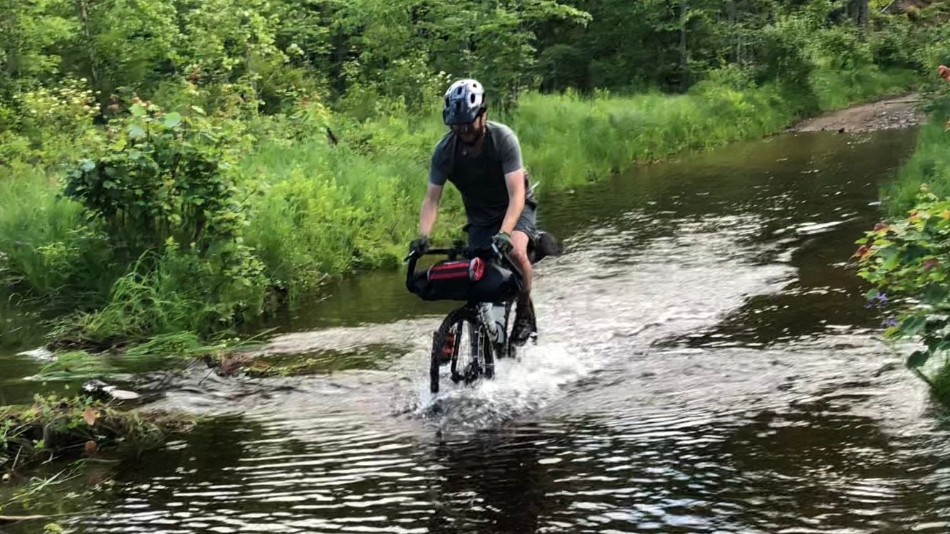
Ride complete, they were just finishing compacting Hancock Rd, so that was fine, but Center Pond and Jefts roads are not to be recommended, unless you like pushing your bike and getting wet and muddy!
75 miles total, and nearly 5,800� of climbing.
The rail trail from Deering down to Bennington is quite nice, a little soft in places but overall a nice way to cover that distance.
75 miles total, and nearly 5,800� of climbing.
The rail trail from Deering down to Bennington is quite nice, a little soft in places but overall a nice way to cover that distance.
Last edited by chiefsilverback; 06-23-19 at 06:09 PM.

