


Route planning: Quebec (CA) > Provo (UT) May-June 2024
 09-06-23, 09:38 AM
#1
Senior Member
Thread Starter
Join Date: Sep 2015
Location: QC Canada
Posts: 1,972
Bikes: Custom built LHT & Troll
Mentioned: 12 Post(s)
Tagged: 0 Thread(s)
Quoted: 846 Post(s)
Liked 149 Times
in
106 Posts
Route planning: Quebec (CA) > Provo (UT) May-June 2024
Early planning stages for next year, to attend a conference in Provo late June (obviously an excuse to justify a few weeks on the road  )
)
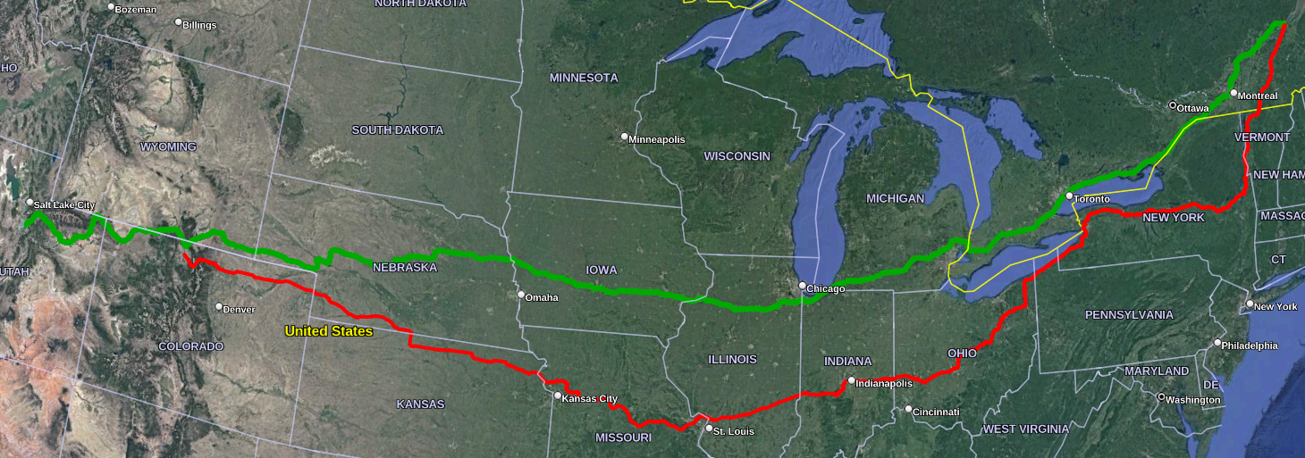
1. Cycle travel (and other apps) would suggest the more direct route, displayed in Green.
2. The Red alternative differs in two ways. (1) it heads south, down to the Empire trail, the idea being to gain a few degrees of warmth as quickly as possible since I'll hit the road first week of May, and (2) rejoins ACA's Eastern Express in Indianapolis.
3. Another possibility is to ride Red down to Buffalo, and then Green (via Hamilton) to Provo.
Comments/suggestions appreciated.
)1. Cycle travel (and other apps) would suggest the more direct route, displayed in Green.
2. The Red alternative differs in two ways. (1) it heads south, down to the Empire trail, the idea being to gain a few degrees of warmth as quickly as possible since I'll hit the road first week of May, and (2) rejoins ACA's Eastern Express in Indianapolis.
3. Another possibility is to ride Red down to Buffalo, and then Green (via Hamilton) to Provo.
Comments/suggestions appreciated.
 09-06-23, 10:28 AM
#2
bicycle tourist
Your route between Montpelier and Indianapolis is not very different from a route I've taken this year. On this page - https://mvermeulen.org/gone2look4america/maps/ and in Red.
= Coming across the Empire Trail and the OTET trail were all nice riding along the way.
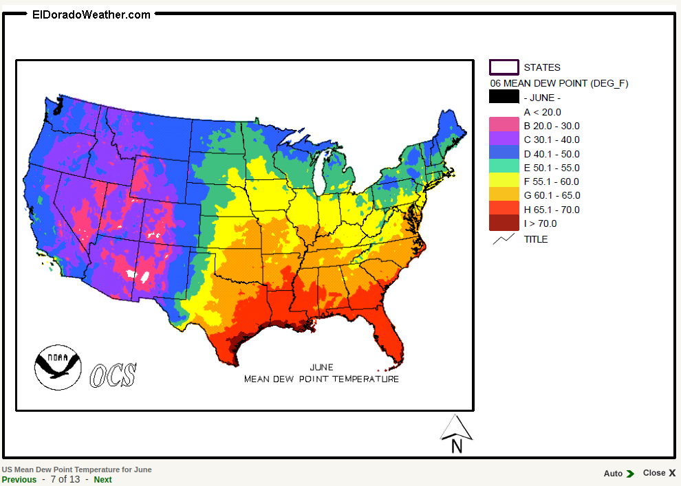
After that I was further north. Mostly because I was getting additional state capitols. However a minor consideration is the heat/humidity as shown by the average dew points. Dew points over 65 are "muggy" so the average still looks mostly reasonable. However, the Illinois, Missouri and eastern Kansas parts are likely to have the most heat+humidity and odds are better if you go a little further north. Later in summer than your June Utah arrival, I'd definitely prefer being further north there and even consider Mount Rushmore and the Black Hills as an interesting via point...
Your route through Colorado is similar to mine. However, rather than turning north at Walden and going over the snowy Range mountains, I am going via Steamboat Springs and then VIA US 40. I've done this route twice the other direction and it is a reasonable route.
= Coming across the Empire Trail and the OTET trail were all nice riding along the way.
After that I was further north. Mostly because I was getting additional state capitols. However a minor consideration is the heat/humidity as shown by the average dew points. Dew points over 65 are "muggy" so the average still looks mostly reasonable. However, the Illinois, Missouri and eastern Kansas parts are likely to have the most heat+humidity and odds are better if you go a little further north. Later in summer than your June Utah arrival, I'd definitely prefer being further north there and even consider Mount Rushmore and the Black Hills as an interesting via point...
Your route through Colorado is similar to mine. However, rather than turning north at Walden and going over the snowy Range mountains, I am going via Steamboat Springs and then VIA US 40. I've done this route twice the other direction and it is a reasonable route.
09-06-23, 01:59 PM
#3
Senior Member
Thread Starter
Join Date: Sep 2015
Location: QC Canada
Posts: 1,972
Bikes: Custom built LHT & Troll
Mentioned: 12 Post(s)
Tagged: 0 Thread(s)
Quoted: 846 Post(s)
Liked 149 Times
in
106 Posts
mev thanks for the feedback. Duly noted WRT dew point. Will adjust once in Buffalo depending on the long range forecast.
09-16-23, 10:51 AM
#4
Junior Member

I am only familiar with the Colorado/Utah portion of your planning. I can't zoom in on your map, but I think it has you going through the Flaming Gorge area of Utah which is desolate and has stiff climbing. It's beautiful, but tough.
The previously mentioned Highway 40 is a relatively easy way to cross the area. It's occasionally busy, but always has a good shoulder. I would leave Highway 40 at Dechesne (high traffic) and take beautiful 35, as we did.
I am mostly a country rider and did extensive research on the best way to traverse Provo. https://www.cycleblaze.com/journals/...heber-city-ut/ This was my route for the day. If you view the next few days, that is a good route.
I live in Colorado, so am biased towards Colorado riding. If you don't mind riding long grades at 4-6%, at altitude, I could suggest a good route.
It sounds like a grand adventure! Have a great ride.
09-16-23, 12:36 PM
#5
bicycle tourist
I am mostly a country rider and did extensive research on the best way to traverse Provo. https://www.cycleblaze.com/journals/...heber-city-ut/ This was my route for the day. If you view the next few days, that is a good route.
1. You went from Vernal to Rangely to Meeker. I presume because you were ending in Rifle. However, I tried Craig/Meeker/Rangely/Vernal this time as opposed to a more direct Craig/Maybell/Dinosaur/Vernal which I've done in the past. I prefer the Meeker/Rangely alternative - both because Meeker is a nice little town and two more moderate days compared to Maybell/Dinosaur.
2. Another alternative between Duchesne and Provo is via Helper/Price. I did that the other direction last time (mostly because I was thinking of going via Moab and then decided against with some excessive heat - so headed north again).
3. US 40 usually has good shoulders. As you noted in your journal you also ran into the section between Naples and Jenson where the shoulder became minimal with a rumble strip in the middle. Some of the oil field sections do have a higher than normal amount of shredded tires with small wires.
09-18-23, 11:03 AM
#6
Senior Member
Thread Starter
Join Date: Sep 2015
Location: QC Canada
Posts: 1,972
Bikes: Custom built LHT & Troll
Mentioned: 12 Post(s)
Tagged: 0 Thread(s)
Quoted: 846 Post(s)
Liked 149 Times
in
106 Posts
Here's a link to an interactive map. Pins have no special meaning other than forcing the routing algorithm to go through specific locations:
.
.
- The default Quebec > Chicago routes north of the Ontario and Erie Lakes. For now I prefer riding south to gain a few degrees of warmth even if it means hundreds more miles and elevation. I plan to start at the beginning of May and I read good things about the Champlain, Empire and Erie trails. Still debating, though.
- The default Chicago > Walden (CO) routing goes through Des Moines. I couldn't believe my eyes when I looked at the elevation stats for central Iowa. Cursory reading of CGOAB confirms that this would have been a succession of hills. Moving to northern Iowa looks much better (7 000 ft less elevation gains...)
- It looks as if the most popular route from Riverside (WY) > Vernal (UT) > Heber City (UT) goes thru highway 40. I'd rather avoid riding an highway shoulder and go through the Browns Park National Refuge instead. There's a 4WD link between country roads that should be passable, and a couple of places where to get water. so hopefully all will be fine.
09-18-23, 11:19 AM
#7
Junior Member
Ah, if you are open to gravel roads, you have many choices. I also lack experience there! I can say that Going north/west from Maybell, CO on 318 and then north on what becomes 430, heading towards Rock Springs, WY is a good dirt road. There is a wild horse herd that is quite famous in that area. Sand Wash Basin wild horses. We have seen them right down on the road. Occasionally there is a bad accident with a wild horse. I've often thought that would be a good bicycle ride, but careful planning of water/food, plus big miles and camping overnight would be necessary.
Browns Park does look enticing. Please keep us informed on your route, it sounds interesting!
Browns Park does look enticing. Please keep us informed on your route, it sounds interesting!
09-18-23, 11:50 AM
#8
Senior Member
Join Date: Jul 2007
Location: South shore, L.I., NY
Posts: 6,885
Bikes: Flyxii FR322, Cannondale Topstone, Miyata City Liner, Specialized Chisel, Specialized Epic Evo
Mentioned: 18 Post(s)
Tagged: 0 Thread(s)
Quoted: 3242 Post(s)
Liked 2,089 Times
in
1,182 Posts
Cannot comment on west of the Missisippi, but the southern route is a good idea, Erie Canal Trail is not all trail, there are some section on road. I would actually recommend skirting the north Adirondacks and come down the east side of the St. Lawrence river. There are a lot of NY State public campgrounds along the Thousand Islands region. It's also flat, so easy riding, then pick up the Erie Canal trail just west of Syracuse, NY. As well, the cycling along Lake Erie is flat and pretty., head to Cleveland then take the Ohio to Erie trail system down to Cinncinatti. I watched a YT last year of a couple crossing the US, they very much enjoyed riding the farm roads of central Indiana and Illinois from St, Louis east to Cinncinati.
 09-18-23, 03:36 PM
#9
bicycle tourist
Here's a link to an interactive map
- It looks as if the most popular route from Riverside (WY) > Vernal (UT) > Heber City (UT) goes thru highway 40. I'd rather avoid riding an highway shoulder and go through the Browns Park National Refuge instead. There's a 4WD link between country roads that should be passable, and a couple of places where to get water. so hopefully all will be fine
I don't know anything on the CO 318 from Maybell but have seen journals of people who went this way. General impression was road was good to the UT/CO border and then quite a bit different after that.
The busiest part of US 40 I found was between Duchesne and Heber City. A lot of twin tanker trucks. On Sunday a lot of pickups pulling camper/trailer. Occasional minimal shoulder for a short instance and a lot of tire debris on the shoulder. Kelly I suggestion of 35 likely avoids it. I took US 40 mostly because a lower summit to get over.
I seem to ride this highway every 10 years (2003, 2013, 2023) and this is the year I've noticed truck traffic more.
There is a trail in lower Provo Canyon but perhaps ~10 miles of pretty busy road on US 189. Mostly ok shoulder. Saw three or four "share the road" bicycle signs but not the most pleasant ride.
