


Biking around Shelter Island?
 07-02-18, 10:26 AM
#1
Full Member
Thread Starter
Join Date: May 2017
Location: Washington, DC
Posts: 466
Bikes: Trek Domane 4.3
Mentioned: 0 Post(s)
Tagged: 0 Thread(s)
Quoted: 193 Post(s)
Liked 50 Times
in
35 Posts
Biking around Shelter Island?
I'm going on a family trip to Shelter Island later this summer. Would like to cycle. Given the island is relatively small, I'm assuming I'll want to ferry on and off, but where to from there? Go north fork or south? Any roads to use or stay away from? I'll probably aim for rides in the 25-50 mile range . . . suggestions welcome!
 07-02-18, 02:42 PM
#2
Senior Member
Two or three times each summer, my wife and I do a ride from Greenport to Sag Harbor via Shelter Island. If you are starting from Shelter Island itself, ride the wide shoulder along Rt. 114 toward the South Ferry. Look out for deer crossing the road! Take your bikes on the South Ferry ($5-6 each way?) and get off in North Haven, where Rt. 114 continues with a nicely marked bike lane. Stay on Rt. 114 all the way to Sag Harbor and enjoy this cool little town. Just don't ride your bike on the street once you get there. You WILL get a summons.
NOTES: Along the way, in North Haven, you will hit a traffic circle. To continue to Sag Harbor, enter at "6:00" and exit at "9:00," as if you are making a left turn. But if you are looking for some cool beach, follow the signs at the traffic circle to Noyack, which is essentially straight ahead. You can always back track and hit Sag Harbor later, but the beach in Noyack is pretty nice.
If you'd like a smaller, more private beach, once you cross the bridge into Sag Harbor, go straight onto Bay Street, check out the boats in the dock to the left (public restrooms there, too) stop for a bite at the Dockside Bar & Grill (American Legion), check out Billy Joel's house at the corner right before it, hit the bike shop right after it if you need to, and continue to Haven's Beach Road. This will take you to a small beach that is a bit rockier than the one in Noyack, but much more private.
I've never ridden much ON Shelter Island itself (outside of Rt. 114), but the ride I have just described is one that I look forward to year-after-year. Enjoy your visit!
(PS: Also check out Greenport. It's a great little town with a lot of "life" in the summer time. On Friday night's there's live music on the boardwalk, and on many other nights there are great bands at Claudio's.) PM me if you want to know more!
07-02-18, 02:48 PM
#3
Senior Member
Use both ferries. It's tough to go wrong out there. On the south end I believe the village of Sag Harbor still has some restrictions on a few streets regarding cycling so pay attention to the signs. There are generally fewer people on the North Fork but also fewer roads. Explore! And visit the Big Duck in Flanders.
The "bike-boat-bike" circumferential ride around Peconic Bay is a local classic of around 65 miles. I'm sure there are many routes for this available for download on Strava / RideWithGps, etc.
Enjoy your stay!
The "bike-boat-bike" circumferential ride around Peconic Bay is a local classic of around 65 miles. I'm sure there are many routes for this available for download on Strava / RideWithGps, etc.
Enjoy your stay!
07-02-18, 04:11 PM
#4
Senior Member
Join Date: Jul 2007
Location: South shore, L.I., NY
Posts: 6,878
Bikes: Flyxii FR322, Cannondale Topstone, Miyata City Liner, Specialized Chisel, Specialized Epic Evo
Mentioned: 18 Post(s)
Tagged: 0 Thread(s)
Quoted: 3236 Post(s)
Liked 2,080 Times
in
1,178 Posts
Here’s a RideWithGPS 24 mile loop I’ve done a few times. It covers pretty much the entire island. We often extend by starting out in Orient and doing a swim at the state park after, but you can go off island, north or south fork for about any extra distance you desire. All good roads out there.
https://ridewithgps.com/routes/27957736
https://ridewithgps.com/routes/27957736
07-02-18, 11:22 PM
#6
Me duelen las nalgas
Join Date: Aug 2015
Location: Texas
Posts: 13,513
Bikes: Centurion Ironman, Trek 5900, Univega Via Carisma, Globe Carmel
Mentioned: 199 Post(s)
Tagged: 0 Thread(s)
Quoted: 4559 Post(s)
Liked 2,802 Times
in
1,800 Posts
It's been decades since I lived on the island but back then I rode my bike everywhere, including to my job in Mashomack forest. I'd like to go back for a visit some day. Looking at Google street view it's changed a little but still looks very familiar.
07-03-18, 10:31 PM
#7
Senior Member

You can also do a nice ride from Sag Harbor to Montauk and back, probably around 60 miles or so but mostly flat until you get to Hither Hills. If you take the ferry north to Greenport you could ride to Orient Point State Park.
07-04-18, 07:16 AM
#8
Senior Member
OR, after enjoying the vibe in Greenport itself, you can take this short little spin to the Hellenic (Greek) Restaurant for some excellent (but pricey) casual outdoor Greek food - AND a little bit of beach:
Greenport to Greek & Beach� From the ferry terminal in Greenport, find your way to 3rd Street, (movie theater/Subway Restaurant)� Cross Rt. 25 and take 3rd St. to the end� Turn right onto Webb St� Bear left onto Main Rd� 4 blocks to Champlin and turn right� At end (cemetery), either turn left onto Manhanset to 25A and Greek restaurant, OR turn right to go to small beach
07-07-18, 11:22 PM
#9
Member
Join Date: Jun 2017
Location: LI south shore
Posts: 29
Bikes: Specialized Tarmac Comp Disc Ultegra, Specialized Roubaix SL4 Comp, Specialized Fat Boy, trek Superfly FS9, Cannondale R400, Specialized StumpJumper
Mentioned: 1 Post(s)
Tagged: 0 Thread(s)
Quoted: 12 Post(s)
Likes: 0
Liked 0 Times
in
0 Posts
Here's another more comprehensive loop, 33 miles, from the south ferry. But I agree, I'd use both ferries - it's a lot of fun.
https://ridewithgps.com/routes/28005772
/Ed
https://ridewithgps.com/routes/28005772
/Ed
07-10-18, 11:26 PM
#10
Newbie
Bike the North Fork
Having grown up on the North Fork I would recommend it for more open roads and less traffic. The geography limits you to mainly east or west travel and there are only two roads going E-W so you won�t get lost. The �Main Road� starts/ends in Greenport and goes west to Riverhead and beyond. It�s Route 25 and goes through the towns. You�ll find services, snacks and stores every few miles. A mile or two north of the Main Road is the �North Road� which goes Orient Point to Riverhead and beyond. It�s been recently repaved and the shoulder (pseudo bike lane) is in pretty good shape and plenty wide. You�ll find less stores and services on this road. It�s the road people use to get places faster.
For a nice ride I recommend you take the ferry to Greenport and ride through town to the North Road. Then head east towards Orient Point. Riding through East Marion you�ll pass the now famous Lavender Fields on the right. Expect MASSIVE traffic on summer weekends which you�ll sail past on a bike. A little further on the left is the Fork & Anchor breakfast & lunch place that�s popular because it�s the only store in East Marion. Notice there are no traffic lights in EM or Orient. The last one on Long Island is back in Greenport. Also in East Marion you can see the grave of Mark Rothko if you�re into that kind of thing. (Check the Google)
Continuing east a few miles consider taking a right at the war memorial obelisk to check out the cute hamlet of Orient. An ice cream parlor, a General Store and lots of cute historic homes dot the streets. Watch for Supreme Court Justice Sonia Sotomayor who summers here. Continue further toward the Orient yacht club and follow the road through the village. Keep going and eventually take a left to get back to the North Road in a few beautiful rural road miles. At the North Road turn right and head for Orient Point. Youll pedal to the end of Long Island and the Cross Sound Ferry dock to watch the folks going to/from Connecticut. There�s a snack shop here too. Before or after stopping at the ferry dock you could ride into Orient Point State Park. It�s 4-5 extra miles round trip on park roads, and bikes are free to enter. It�s a nice ride and worth the trip.
Since you made it to the Point head back to Greenport and the ferry. You can pull into Orient ice cream shop or the Fork & Anchor in East Marion if you need a snack. Or as you�re leaving Orient a little past the obelisk stop at the Candy Man for some very good chocolate or peanut brittle.
The whole trip is about 22 miles. Add on 4-5 miles if you go into Orient State Park. There can be a headwind/tailwind but you�ll really only notice it on the unprotected causeway that connects East Marion to Orient. Overall it�s a nice easy flat ride.
07-11-18, 07:37 PM
#12
Senior Member
It's a narrow peninsula. You ride on the shoulder of a 2 lane paved road to the end of the road and back. There is a restaurant and deli as well as the ferry to Connecticut at the entrance to the park.
07-12-18, 04:08 AM
#13
Senior Member
I think you are talking about the ride along Sound Avenue TO Orient State Park. I am asking about Orient State Park itself, which is at the end of Sound Avenue, adjacent to the ferry entrance. Someone mentioned it as a way to extend the ride from Greenport to Orient Point.
07-12-18, 07:48 AM
#14
Senior Member
Join Date: Jul 2007
Location: South shore, L.I., NY
Posts: 6,878
Bikes: Flyxii FR322, Cannondale Topstone, Miyata City Liner, Specialized Chisel, Specialized Epic Evo
Mentioned: 18 Post(s)
Tagged: 0 Thread(s)
Quoted: 3236 Post(s)
Liked 2,080 Times
in
1,178 Posts
I think you are talking about the ride along Sound Avenue TO Orient State Park. I am asking about Orient State Park itself, which is at the end of Sound Avenue, adjacent to the ferry entrance. Someone mentioned it as a way to extend the ride from Greenport to Orient Point.
As clarification, the entrance to Orient Beach State Park is all of 2/10th a mile west of the Orient-New London ferry terminal. Right between is the US government facility and ferry that services Plum Island.
The beach at Orient, as well as other facilities, is 2 miles SW down the paved access park road.
Last edited by Steve B.; 07-12-18 at 07:52 AM.
07-12-18, 11:30 AM
#15
Senior Member
I think you are talking about the ride along Sound Avenue TO Orient State Park. I am asking about Orient State Park itself, which is at the end of Sound Avenue, adjacent to the ferry entrance. Someone mentioned it as a way to extend the ride from Greenport to Orient Point.
Last edited by dendawg; 07-12-18 at 11:35 AM.
07-12-18, 01:25 PM
#16
Senior Member
Wow! This is blowing my mind! I have ridden out that way and used the ferry so many times and I never knew about this state park. I thought the one you were describing was that rustic-looking park right at the ferry entrance, but this appears to be a very cool hidden gem that I've got to find time to ride. Too bad, because I just returned from Connecticut on the Orient Point Ferry this past Monday and was looking to kill some time before heading home. I'd have ridden it right then and there. I guess I've got to add it to the Later-This-Summer List.
07-12-18, 02:03 PM
#17
Newbie
Orient Beach State Park Vs Orient Point County Park
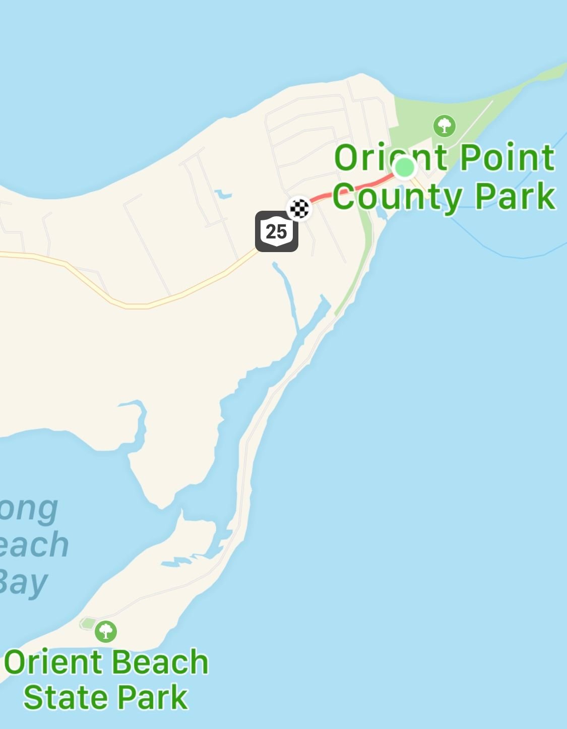
Just to clarify, my previous comments were about Orient Beach State Park. It�s entrance is on the south side of the street just before reaching the ferry terminal.
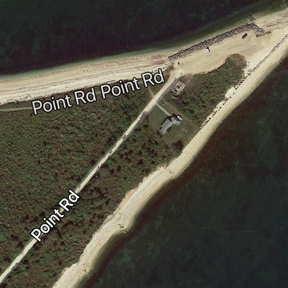
Orient Point County Park is another, slightly more difficult ride. At the end of Rt 25 instead of turning right to the ferry go straight on the road. There are signs that say �Private Road� that can be ignored because the Point Road is just past them. Take the immediate right on the �fishing road� and follow it a mile or so to the parking area. The road is all beach stone and a difficult to ride so be ready for a slow bumpy ride in a low gear. At the point you can see Plum Island, Plum Gut and both the Long Island Sound and Gardiners Bay. As you head back consider taking the grassy path on the north side that is marked Point Road. It is not a road but is easily passable by bike. A mile or so later the path will dump into a quiet neighborhood and you can make your way back to the North Road aka Rt 25.
Last edited by Tbobx; 07-12-18 at 02:14 PM. Reason: Add more details
07-12-18, 03:12 PM
#18
Senior Member
Or I can just skip that county park altogether and ride the state park instead! (Yeah, my days of bouncing around on beach stone are behind me.)
07-13-18, 11:19 AM
#19
Full Member
Thread Starter
Join Date: May 2017
Location: Washington, DC
Posts: 466
Bikes: Trek Domane 4.3
Mentioned: 0 Post(s)
Tagged: 0 Thread(s)
Quoted: 193 Post(s)
Liked 50 Times
in
35 Posts
Yeah, the state park looks better for a (road) bike ride, but the county park looks like a nice place to get out to for the views as well.
08-09-18, 12:12 PM
#20
Full Member
Thread Starter
Join Date: May 2017
Location: Washington, DC
Posts: 466
Bikes: Trek Domane 4.3
Mentioned: 0 Post(s)
Tagged: 0 Thread(s)
Quoted: 193 Post(s)
Liked 50 Times
in
35 Posts
Thanks everyone for the tips . . . pretty humid the days I was there. If anyone stumbles across this thread, here are a couple of the routes I took (roughly - I missed a couple turns and have moved the start/end a bit to protect the privacy of the rental we were in). Feel free to copy for yourself if you go. Overall was really nice biking - SI has a few short hills to force the legs to work just a bit, but nothing to ruin a vacation.
https://ridewithgps.com/routes/28277395
https://ridewithgps.com/routes/28268023
https://ridewithgps.com/routes/28277395
https://ridewithgps.com/routes/28268023
08-09-18, 04:50 PM
#21
Senior Member
Join Date: Jul 2007
Location: South shore, L.I., NY
Posts: 6,878
Bikes: Flyxii FR322, Cannondale Topstone, Miyata City Liner, Specialized Chisel, Specialized Epic Evo
Mentioned: 18 Post(s)
Tagged: 0 Thread(s)
Quoted: 3236 Post(s)
Liked 2,080 Times
in
1,178 Posts
Thanks everyone for the tips . . . pretty humid the days I was there. If anyone stumbles across this thread, here are a couple of the routes I took (roughly - I missed a couple turns and have moved the start/end a bit to protect the privacy of the rental we were in). Feel free to copy for yourself if you go. Overall was really nice biking - SI has a few short hills to force the legs to work just a bit, but nothing to ruin a vacation.
https://ridewithgps.com/routes/28277395
https://ridewithgps.com/routes/28268023
https://ridewithgps.com/routes/28277395
https://ridewithgps.com/routes/28268023
I especially like the north fork route, hits some nice spots north of Mattituck
08-09-18, 07:05 PM
#22
Full Member
Thread Starter
Join Date: May 2017
Location: Washington, DC
Posts: 466
Bikes: Trek Domane 4.3
Mentioned: 0 Post(s)
Tagged: 0 Thread(s)
Quoted: 193 Post(s)
Liked 50 Times
in
35 Posts
That part was nice - Soundview Ave., despite its misleading name, was a very nice, quiet stretch of road. This loop is somewhat scalable too - one can cut across from the bay side to the sound side at several places.
08-10-18, 04:30 AM
#23
Senior Member


