


Creating loops?
 12-31-18, 12:17 PM
#1
Senior Member
Thread Starter
Join Date: Mar 2008
Posts: 1,514
Mentioned: 16 Post(s)
Tagged: 0 Thread(s)
Quoted: 231 Post(s)
Likes: 0
Liked 10 Times
in
9 Posts
Creating loops?
Maybe dumb question...but are there any good apps for creating a loop style route? I hate coming back the same way i set off and i think it could be a nice thing to have for overnight tours or short weekend tours with some camping.
Half the fun is going somewhere new and exploring without covering the same route twice but also remaining as bike friendly as possible.
Also.....id imagine to get far enough away, i would need to the gear in my car, start from a certain point and end up back my car. I am not very familar with GPS apps but is there something that lets you know where your car is located in relation to your route? I believe there are many threads that talk about places to potentially park but finding your way back to the car is another story if you are in a unfamiliar area.
 12-31-18, 12:27 PM
#2
Banned
M-apps
Airports,, buy return trip tickets , 91 my loop was several months long AMS and as far east as Poland and back..
I have a nice collection of paper maps from my tours in Europe.
....
I have a nice collection of paper maps from my tours in Europe.
....
Last edited by fietsbob; 01-01-19 at 10:26 AM.
12-31-18, 12:49 PM
#3
Senior Member

Join Date: Nov 2014
Location: Eugene, Oregon, USA
Posts: 27,547
Mentioned: 217 Post(s)
Tagged: 0 Thread(s)
Quoted: 18377 Post(s)
Liked 4,512 Times
in
3,354 Posts
There are a few GPS apps for cycling.
I do my route planning with Strava since it is free.
RideWithGPS and MapMyRide are also popular.
Strava also has a HEAT MAP that you can see where others have ridden, although popular doesn't always mean best.
As part of planning my route, I try to memorize as much of the route as possible, although GPS can be handy for critical turns.
I do a lot of car-free doorstep rides, so I am somewhat familiar with my routes. The biggest thing is that if I do a morning/evening commute, trying to remember the route I came on so I can choose a different route for heading home.
Still, it is interesting to try something new, or explore different roads.
One of the issues around here for doing loops on the longer routes is mountains can get in the way, and there can be limited cross-overs. So, heading up the Willamette river and back the McKenzie river becomes about a 150 mile ride, which is a long one-day ride, although there would be some excellent camping at the halfway point. I should keep that in mind.
If you map your route using GPS, then you can see where you have been, and thus find your way back to the start point. Just make sure, if you park and ride to turn off the recording before you hop in the car.
12-31-18, 01:23 PM
#4
Senior Member
Join Date: Jan 2010
Posts: 39,243
Mentioned: 211 Post(s)
Tagged: 1 Thread(s)
Quoted: 18418 Post(s)
Liked 15,559 Times
in
7,332 Posts
1. Decide where to park your car.
2. Map out a loop route using maps, on line or otherwise.
3. Ride said loop and you will return to your car.
 12-31-18, 01:43 PM
#5
Senior Member
Without an "app"
there are numerous mapping apps that allow you to leave a "pinpoint" on locations.
12-31-18, 02:03 PM
#6
Senior Member
Sorry, but I am chuckling at this thread, especially after reading indy and djb's replies, which are exactly what I would have said.
Nothing personal, scale. I assume you are younger than I am and I guess there is just a generation gap between those of us who managed to survive our entire lives without "apps" and GPS and those who don't trust the centuries-old, tried and true methods of getting from one point to another.
Unless what you are really asking for is an app that will suggesta return route that meets certain specific user-entered criteria (ex: scenic, safe, fortified with places to eat or pee), then I can't imagine any set of algorithms that would do a better job of mapping the return end of your loop than a map and a yellow highlighter - and perhaps Google Maps "Street View" feature so you can see exactly the types of roads you'd be riding.
12-31-18, 02:07 PM
#7
Every day a winding road

Maybe dumb question...but are there any good apps for creating a loop style route? I hate coming back the same way i set off and i think it could be a nice thing to have for overnight tours or short weekend tours with some camping.
Half the fun is going somewhere new and exploring without covering the same route twice but also remaining as bike friendly as possible.
Also.....id imagine to get far enough away, i would need to the gear in my car, start from a certain point and end up back my car. I am not very familar with GPS apps but is there something that lets you know where your car is located in relation to your route? I believe there are many threads that talk about places to potentially park but finding your way back to the car is another story if you are in a unfamiliar area.
Half the fun is going somewhere new and exploring without covering the same route twice but also remaining as bike friendly as possible.
Also.....id imagine to get far enough away, i would need to the gear in my car, start from a certain point and end up back my car. I am not very familar with GPS apps but is there something that lets you know where your car is located in relation to your route? I believe there are many threads that talk about places to potentially park but finding your way back to the car is another story if you are in a unfamiliar area.

But I also agree with you that loop tours seem to be better.
Sometimes it is not possible to do a loop. Or at least not practical. . Take the GAP trail for example. Yes you could do a loop but time might not allow it. And on top of it you would have to ride a lot of hills, Long story short you simply might not be able to do a loop based off of various conditions.
Or you could go with a pre planned loop.
Well if you leave out of Spokane (the nearest major city) it is more of a lollipop. 
The International Selkirk Loop :: Rocky Mountains Scenic Drive - International Selkirk Loop
12-31-18, 02:53 PM
#9
Senior Member
Join Date: Nov 2014
Location: Eugene, Oregon, USA
Posts: 27,547
Mentioned: 217 Post(s)
Tagged: 0 Thread(s)
Quoted: 18377 Post(s)
Liked 4,512 Times
in
3,354 Posts
Well hate to say it but I agree with you. It is a dumb question.
But I also agree with you that loop tours seem to be better.
Sometimes it is not possible to do a loop. Or at least not practical. . Take the GAP trail for example. Yes you could do a loop but time might not allow it. And on top of it you would have to ride a lot of hills, Long story short you simply might not be able to do a loop based off of various conditions.
Or you could go with a pre planned loop. Well if you leave out of Spokane (the nearest major city) it is more of a lollipop.
The International Selkirk Loop :: Rocky Mountains Scenic Drive - International Selkirk Loop
But I also agree with you that loop tours seem to be better.
Sometimes it is not possible to do a loop. Or at least not practical. . Take the GAP trail for example. Yes you could do a loop but time might not allow it. And on top of it you would have to ride a lot of hills, Long story short you simply might not be able to do a loop based off of various conditions.
Or you could go with a pre planned loop.
Well if you leave out of Spokane (the nearest major city) it is more of a lollipop. The International Selkirk Loop :: Rocky Mountains Scenic Drive - International Selkirk Loop

Thinking about this, it would really depend on the route. When I was riding the Katy Trail in Missouri, almost all of my rides were simple out and back rides, other than loops around Creve Coeur Lake.
But, there are a lot of possibilities to explore road rides. Long point to point rides might have some weaving back and forth on the return trip.
12-31-18, 03:24 PM
#10
Pennylane Splitter
Join Date: Sep 2012
Location: Orange County, California
Posts: 1,879
Bikes: Yes
Mentioned: 14 Post(s)
Tagged: 0 Thread(s)
Quoted: 1804 Post(s)
Liked 1,439 Times
in
989 Posts
If you can expand your outlook away from cars and 'loops', you could try flying to a distant location and riding back (previously mentioned). Or if you're located in a city/area that has Amtrak service, you could use the train to get to a starting point. I'd go with Amtrak, since bicycles are transported for free on most routes and you get to enjoy the scenery as the train rolls down the tracks. An all-day ride on the 'commuter' train service in my area gets me about 3-4 bicycle-riding days away from home.
12-31-18, 06:56 PM
#11
Senior Member
Join Date: Sep 2015
Location: Left Coast, Canada
Posts: 5,126
Mentioned: 24 Post(s)
Tagged: 0 Thread(s)
Quoted: 2236 Post(s)
Liked 1,314 Times
in
707 Posts
I would just spend time on google maps looking at areas you want to tour and how to connect roads/paths. Once you get a basic idea you can use some other app to fine tune if you feel it's necessary. One can also use the one way airport/train idea as bob suggested (did I just say that?).
I've gotten into VIA Rail roll on roll off service lately after discovering a route that goes up the middle of my province into the heart of the Rockies at Jasper. From there I can go a couple of ways back home or get off sooner for a shorter trip. Beyond Jasper it's easier to fly.
I've gotten into VIA Rail roll on roll off service lately after discovering a route that goes up the middle of my province into the heart of the Rockies at Jasper. From there I can go a couple of ways back home or get off sooner for a shorter trip. Beyond Jasper it's easier to fly.
12-31-18, 07:31 PM
#12

buy my bikes

Join Date: Jun 2014
Location: Michigan
Posts: 1,800
Bikes: my very own customized GUNNAR CrossHairs
Mentioned: 19 Post(s)
Tagged: 0 Thread(s)
Quoted: 519 Post(s)
Liked 428 Times
in
249 Posts
I use google maps and hit the "Bicycle" for MUPs (green) and dirt trails (brown).
Also for dirt roads you can check: https://gravelmap.com/
It take a bit of work. But I've used it for several multi day loops from home & back.

Also for dirt roads you can check: https://gravelmap.com/
It take a bit of work. But I've used it for several multi day loops from home & back.
12-31-18, 09:33 PM
#13
In Real Life

Join Date: Jan 2003
Location: Down under down under
Posts: 52,152
Bikes: Lots
Mentioned: 141 Post(s)
Tagged: 0 Thread(s)
Quoted: 3203 Post(s)
Liked 596 Times
in
329 Posts
Maybe dumb question...but are there any good apps for creating a loop style route? I hate coming back the same way i set off and i think it could be a nice thing to have for overnight tours or short weekend tours with some camping.
Half the fun is going somewhere new and exploring without covering the same route twice but also remaining as bike friendly as possible.
Also.....id imagine to get far enough away, i would need to the gear in my car, start from a certain point and end up back my car. I am not very familar with GPS apps but is there something that lets you know where your car is located in relation to your route? I believe there are many threads that talk about places to potentially park but finding your way back to the car is another story if you are in a unfamiliar area.
Half the fun is going somewhere new and exploring without covering the same route twice but also remaining as bike friendly as possible.
Also.....id imagine to get far enough away, i would need to the gear in my car, start from a certain point and end up back my car. I am not very familar with GPS apps but is there something that lets you know where your car is located in relation to your route? I believe there are many threads that talk about places to potentially park but finding your way back to the car is another story if you are in a unfamiliar area.
__________________
Rowan
My fave photo threads on BF
Century A Month Facebook Group
Machka's Website
Photo Gallery
Rowan
My fave photo threads on BF
Century A Month Facebook Group
Machka's Website
Photo Gallery
01-01-19, 03:44 PM
#14
Senior Member
Sorry to come down so hard on you, man. I tend to ask that kind of question sometime around late January/early February, when I haven't been on the bike for 3-4 months and I'm bored enough to just throw ANYTHING up on the forum and see if it sticks.
I'm glad you got some productive replies, though, rather than just the potshots some of us posted. I particularly agree with Spinnaker's comment that loop tours are definitely "better," and with Skidder's suggestion to consider a one-way route that involves train or airplane travel in one direction and cycling in the other. This would be particularly preferable to me over back-tracking the same route home in cases where there is no good "loop route." You can also ride twice as far (or more) without repeating any of the scenery along the way.
I'm glad you got some productive replies, though, rather than just the potshots some of us posted. I particularly agree with Spinnaker's comment that loop tours are definitely "better," and with Skidder's suggestion to consider a one-way route that involves train or airplane travel in one direction and cycling in the other. This would be particularly preferable to me over back-tracking the same route home in cases where there is no good "loop route." You can also ride twice as far (or more) without repeating any of the scenery along the way.
01-01-19, 08:24 PM
#15
Senior Member
Scale,
The only dumb questions are those you should have asked, but didn't.
Personally I like to have a paper map, and use the phone or GPS as a bailout if I get a bit turned around. Hagstrom Atlas maps are excellent if they are available for your area. I do a bit of off trail backpacking in the northern Rockies, and would NOT head out there dependent on a device without a USGS topo map. Not so critical for bike touring in inhabited areas, but, still.....
MRV, thanks for that link to gravelmap. I loves me a good stretch of dirt road, the remoter and more manure strewn, the better. I'll be zooming into the options in central NY state momentarily.
01-02-19, 06:41 AM
#16
Senior Member
Join Date: Sep 2013
Location: NE Oklahoma (*really* NE)
Posts: 108
Bikes: 1985 Raleigh Portage, 1976 Araya commuter (yes, they make frames)
Mentioned: 0 Post(s)
Tagged: 0 Thread(s)
Quoted: 42 Post(s)
Likes: 0
Liked 7 Times
in
5 Posts
I think folks are being a bit harsh.
Route finding and planning is a skill we have to develop over time. Once acquired, it seems second nature.
One thought for the OP to consider is a lollipop route. The ride begins and ends with the same route, but in the middle you add a loop. I like lollipop routes because they minimize the repetitive sections while also providing a mental relief on the last leg when I may be tired and not wanting to deal with routing unfamiliar roads.
If you're riding in your "home territory" (however you define that) I'd recommend buying a large paper map or atlas. It will show you so much more at one glance than any app or online tool. For an area you'll ride a lot, it's a great route planning investment.
Happy riding!
01-02-19, 09:32 AM
#17

don't try this at home.

Join Date: Jan 2006
Location: N. KY
Posts: 5,940
Mentioned: 10 Post(s)
Tagged: 0 Thread(s)
Quoted: 974 Post(s)
Liked 512 Times
in
352 Posts
For local rides, I use ridewithgps.com. It's fast and easy to choose between alternatives to refine the route -- either drag the route to a new road or undo/redo as needed.
Strava Route Builder
For unfamiliar areas, I like the Strava Route Builder. (a free strava login is needed.) I turn on the Heat Map option, then begin by clicking the start point and the destination. It routes by using the most popular biking roads instead of the obvious direct route. From there, I drag or undo/redo as needed. (some popular roads can be gravel, and some may just be the easy way out of town for local riders. But the routes it makes are often very good to excellent.)
I also avoid roads that have a lot less biking activity compared to other roads nearby. Cyclists are avoiding that road -- often for traffic reasons.
These routes often have a lot of turns, which works fine with GPS navigation, not so easy with a cue sheet.
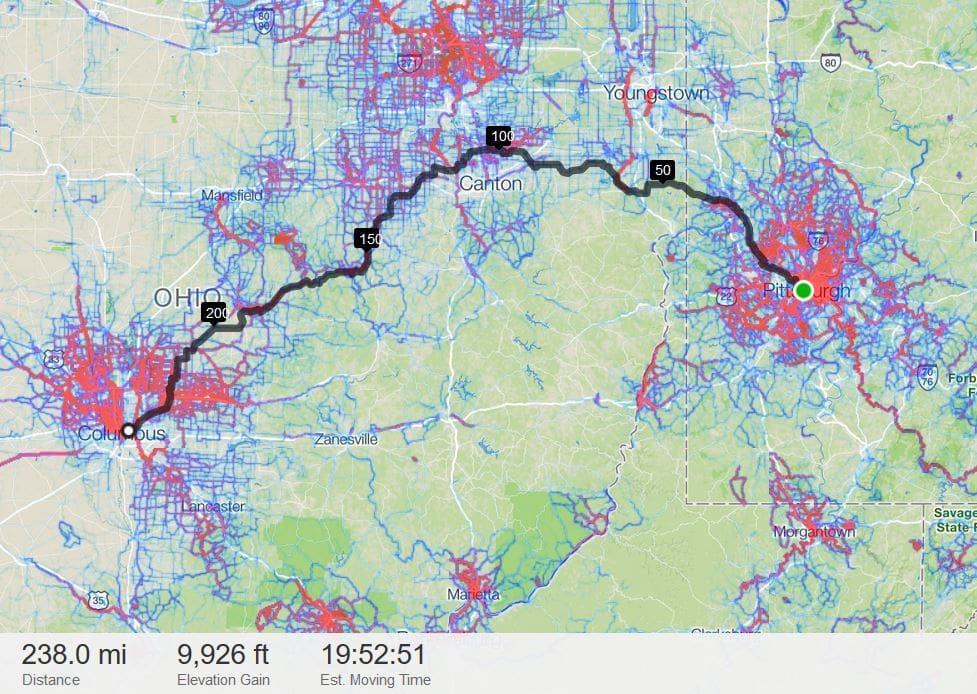
For example, just clicking Pittsburgh PA and Columbus OH, here's the default route it made. I would zoom in and refine it from there.
Since there are many more riders near cities, it routed near them. I would probably want a more rural route, so I could drag the line and it would still pick locally popular roads.
Strava Route Builder
For unfamiliar areas, I like the Strava Route Builder. (a free strava login is needed.) I turn on the Heat Map option, then begin by clicking the start point and the destination. It routes by using the most popular biking roads instead of the obvious direct route. From there, I drag or undo/redo as needed. (some popular roads can be gravel, and some may just be the easy way out of town for local riders. But the routes it makes are often very good to excellent.)
I also avoid roads that have a lot less biking activity compared to other roads nearby. Cyclists are avoiding that road -- often for traffic reasons.
These routes often have a lot of turns, which works fine with GPS navigation, not so easy with a cue sheet.
For example, just clicking Pittsburgh PA and Columbus OH, here's the default route it made. I would zoom in and refine it from there.
Since there are many more riders near cities, it routed near them. I would probably want a more rural route, so I could drag the line and it would still pick locally popular roads.
Last edited by rm -rf; 01-02-19 at 09:38 AM.
01-07-19, 08:28 AM
#18
For The Fun of It

Join Date: May 2007
Location: Louisissippi Coast
Posts: 5,852
Bikes: Lynskey GR300, Lynskey Backroad, Litespeed T6, Lynskey MT29, Burley Duet
Mentioned: 12 Post(s)
Tagged: 0 Thread(s)
Quoted: 2135 Post(s)
Liked 1,647 Times
in
829 Posts
I am a bit of a Luddite, so it may not suit your needs, but I'd recommend piddling around on mapmyride.com It has been a very useful tool for me when I have done route planning in unfamiliar locations. Between it and Google maps I am well served. They aren't really apps and they don't need to be. As long as you have service on your phone they work. I have even printed paper printouts of my mapmyride routes. On parts that may prove confusing and/or where I may not have cell service, I have taken pics of the map on the computer screen with my cell phone.
01-07-19, 09:01 AM
#19
Full Member
Maybe dumb question...but are there any good apps for creating a loop style route? I hate coming back the same way i set off and i think it could be a nice thing to have for overnight tours or short weekend tours with some camping.
Half the fun is going somewhere new and exploring without covering the same route twice but also remaining as bike friendly as possible.
Half the fun is going somewhere new and exploring without covering the same route twice but also remaining as bike friendly as possible.
Also.....id imagine to get far enough away, i would need to the gear in my car, start from a certain point and end up back my car. I am not very familar with GPS apps but is there something that lets you know where your car is located in relation to your route? I believe there are many threads that talk about places to potentially park but finding your way back to the car is another story if you are in a unfamiliar area.
Alternatively, OSMand is an offline routing app (so long as you have the relevant maps downloaded in advance). you can do similar with this app in terms of marking your car's location.
01-07-19, 08:17 PM
#20
Senior Member
Hey, that https://cycle.travel/map site looks pretty useful. Thanks for the link!
01-08-19, 03:50 AM
#21
Full Member
Hey, that https://cycle.travel/map site looks pretty useful. Thanks for the link!
It's great for suggesting routes that are easily adaptable, the round trip feature is pretty useful and there is also the option of selecting a startpoint and getting it to suggest (loop) routes of specified distances - very handy if you want to go for a spin from home that's not your usual route.
For general planning, it shows most established bike routes in an area.
Enjoy!
01-10-19, 11:17 AM
#22
Let's Ride!

Join Date: Jul 2008
Location: Triad, NC USA
Posts: 2,569
Bikes: --2010 Jamis 650b1-- 2016 Cervelo R2-- 2018 Salsa Journeyman 650B
Mentioned: 22 Post(s)
Tagged: 0 Thread(s)
Quoted: 327 Post(s)
Liked 37 Times
in
24 Posts
Hey, that https://cycle.travel/map site looks pretty useful. Thanks for the link!
01-15-19, 09:08 AM
#23
Full Member
01-15-19, 09:31 AM
#24
Sophomore Member

Join Date: Jan 2019
Posts: 2,531
Mentioned: 12 Post(s)
Tagged: 0 Thread(s)
Quoted: 1628 Post(s)
Liked 1,057 Times
in
631 Posts
I remember on of the first issues of Bicycling magazine I ever picked up, must have been late 70's or early 80's, advised that if at every intersection, you keep consistently making right turns (or consistent left turns) that it's impossible to get lost and that you would eventually wind up right back where you started. The definition of the word "eventually" being the key term here. 
Silly and oversimplified, sure, but there is a certain amount of truth in it.
Silly and oversimplified, sure, but there is a certain amount of truth in it.
01-16-19, 07:05 AM
#25
Senior Member

Join Date: May 2008
Posts: 7,384
Mentioned: 49 Post(s)
Tagged: 0 Thread(s)
Quoted: 800 Post(s)
Liked 218 Times
in
171 Posts
Creating loops?
Personally, nearly all my rides start at home and return there, saving more time for cycling. I was captived by this thread on the Touring Forum, “I'm taking off on another 2 day trip tomorrow”
Maybe dumb question...but are there any good apps for creating a loop style route? I hate coming back the same way i set off and i think it could be a nice thing to have for overnight tours or short weekend tours with some camping.
Half the fun is going somewhere new and exploring without covering the same route twice but also remaining as bike friendly as possible.
Also.....id imagine to get far enough away, i would need to the gear in my car, start from a certain point and end up back my car....
Half the fun is going somewhere new and exploring without covering the same route twice but also remaining as bike friendly as possible.
Also.....id imagine to get far enough away, i would need to the gear in my car, start from a certain point and end up back my car....
I've been doing these fun rides lately... Pick a cool town about 50 or 60 scenic miles away. Book a nice room near town. Ride there (in my case, with my dog along). And then have my wife drive there to meet for a nice, romantic night on the town.
It takes her an hour or two, to drive to where it takes me and my 20LB dog to get in a leisurely 6 hours or so. Some fine dining. A hike. Shopping. Maybe live music.
Next morning, charming breakfast, etc... Then I ride home, usually a different route.
It has been great. I get two days of serious riding, and she gets fun little get-a-ways close to home. We are exploring towns near us that we would otherwise never spend a night in, except that for a cyclist, it is a day's journey.
Healdsburg, CA. a few weeks ago
Halfmoon Bay, CA. a couple weeks ago
Tomorrow, Guerneville, CA. Staying at a place built in 1905. Cabins on the Russian River.
I guess you could call it short range, luxury touring with a spousal inclusion component.
Anyone else into this kind of thing? Or lucky enough to have a girl that will do the rides with you?
…I have thought about such rides for a long time...
I recently posted: A couple years ago I thought about making up such list for weekend getaways, as you described, and posting to the local Metro Boston thread.
We live in downtown Boston, and can go out in all directions (except eastward into the Atlantic Ocean). So for here on the Right Coast, counterclockwise around Boston, such destinations would be:
- Newburyport, MA (did a mutual cycle trip there once)
- Portsmouth, NH
- Nashua, NH
- Lowell, MA
- Worcester, MA
- Providence, RI (did a car weekend trip there)
- Plymouth, MA (one mutual cycle trip there).
Last edited by Jim from Boston; 01-16-19 at 07:23 AM.