


Route planning on an Android tablet?
 07-19-12, 03:52 AM
#1
Junior Member
Thread Starter
Join Date: Apr 2008
Posts: 6
Mentioned: 0 Post(s)
Tagged: 0 Thread(s)
Quoted: 1 Post(s)
Likes: 0
Liked 0 Times
in
0 Posts
Route planning on an Android tablet?
I use oruxmaps on an andoid phone to follow routes for touring...
I also take my android tablet with me for whatever...
I havn't found a website for route planning that works well on the tablet browser.
Mapmyride, bikeroute toaster etc all kind of half work ish...
A bike route planning app for android would be the ticket but i cant seem to find one...
Anyone got any ideas?
thanks
 07-19-12, 05:53 AM
#2
Senior Member
Join Date: Mar 2007
Location: Long Island, NY
Posts: 636
Mentioned: 0 Post(s)
Tagged: 0 Thread(s)
Quoted: 8 Post(s)
Likes: 0
Liked 0 Times
in
0 Posts
I use Ride with GPS as my route planner, but do so on a laptop. I "can" do it on my 7" Samsung tablet but find using my finger as a pointer less precise then either a mouse or a laptop pointer. You can zoom in to make the finger points more precise but then you lose the wider view of the map. Samsung I know makes a stylus to improve accuracy, but there's no slot in the tablet to store it, so I don't use one.
So no good answers.
SB
So no good answers.
SB
07-19-12, 07:13 AM
#3
Junior Member
Thread Starter
Join Date: Apr 2008
Posts: 6
Mentioned: 0 Post(s)
Tagged: 0 Thread(s)
Quoted: 1 Post(s)
Likes: 0
Liked 0 Times
in
0 Posts
That's the point. Much happier at home on the desktop with 2 screens planning a route. but the tablet is perfect to take on the ride and with a 10 inch screen is big enough for rout planing, its just that the route planing sites don't work well on the tablet brouser. they all behave wierd... unless someone else has some better info
07-19-12, 08:08 AM
#4
Banned
still have to put in a good word for paper maps. 
U Geography departments have Map Libraries.
U Geography departments have Map Libraries.
07-19-12, 11:35 AM
#5
Senior Member
Join Date: Mar 2007
Location: Long Island, NY
Posts: 636
Mentioned: 0 Post(s)
Tagged: 0 Thread(s)
Quoted: 8 Post(s)
Likes: 0
Liked 0 Times
in
0 Posts
The other issue you will deal with is since you're touring, will you have WiFi access at where ever you are stopped ?, a dn I am assuming you want to be able to plan the next days route ?.
Only mapping program I know of for Android (or Mac iPad for that matter) that has all the maps on the device and does not need WiFi is CoPilot. I use CoPilot as a car GPS device, it's the best I've ever used but it does not function like MapMyRide, RideWithGPS or the others in terms of point and click follow the roads, create a route.
Only mapping program I know of for Android (or Mac iPad for that matter) that has all the maps on the device and does not need WiFi is CoPilot. I use CoPilot as a car GPS device, it's the best I've ever used but it does not function like MapMyRide, RideWithGPS or the others in terms of point and click follow the roads, create a route.
07-19-12, 02:21 PM
#6
Junior Member
Thread Starter
Join Date: Apr 2008
Posts: 6
Mentioned: 0 Post(s)
Tagged: 0 Thread(s)
Quoted: 1 Post(s)
Likes: 0
Liked 0 Times
in
0 Posts
intenet access is usually reasonably easy to deal with... from cafe wifi to pay as you go sim card with internet access...
on orux you have downloadable offline maps. there is also a route planning function its just quite rudimentary. the fully functioned planners have road following options and elevation info.
what would be fantastic would be a proper rout planner dirctly in orux or as a stand alone app with downloadable maps for ofline use... but its not looking good
07-21-12, 05:45 AM
#9

Membership Not Required

Join Date: Jan 2005
Location: On the road-USA
Posts: 16,855
Bikes: Giant Excursion, Raleigh Sports, Raleigh R.S.W. Compact, Motobecane? and about 20 more! OMG
Mentioned: 5 Post(s)
Tagged: 0 Thread(s)
Quoted: 70 Post(s)
Likes: 0
Liked 15 Times
in
14 Posts
Let us know what you find, I run a couple of Android devices. I also use paper maps or a Delorme Etrex.
Aaron
Aaron
__________________
Webshots is bailing out, if you find any of my posts with corrupt picture files and want to see them corrected please let me know. :(
ISO: A late 1980's Giant Iguana MTB frameset (or complete bike) 23" Red with yellow graphics.
"Cycling should be a way of life, not a hobby.
RIDE, YOU FOOL, RIDE!"_Nicodemus
"Steel: nearly a thousand years of metallurgical development
Aluminum: barely a hundred
Which one would you rather have under your butt at 30mph?"_krazygluon
12-03-18, 01:56 PM
#10
Newbie
Join Date: Dec 2018
Posts: 1
Mentioned: 0 Post(s)
Tagged: 0 Thread(s)
Quoted: 0 Post(s)
Likes: 0
Liked 0 Times
in
0 Posts
Tablet using wireless trackball or mouse
I see that this is an old thread, but the issue is not yet resolved as far as I've seen. There is still no simple way of doing this worked out. We often want to modify routes at the end of the day, or after a detour was necessary and that just isn't possible without either a laptop or terrible automatic routing. We generate routes at home with RWGPS, and produce various alternates, but the issue remains, especially for long tours. We are now using an old phone with the RWGPS app aside our Garmin 1000, but both require planning to be done elsewhere. I feel confident that the right tablet and a wireless pointing device such as pen or trackball would be sufficient so long as it will run on that device. So, how substantial of a tablet would be necessary?
12-03-18, 02:03 PM
#11
Every day a winding road

That's the point. Much happier at home on the desktop with 2 screens planning a route. but the tablet is perfect to take on the ride and with a 10 inch screen is big enough for rout planing, its just that the route planing sites don't work well on the tablet brouser. they all behave wierd... unless someone else has some better info
That doesn't help when you are out on the road and you come across a road that is out unexpectedly or you can't take the traffic any more on your chosen route and looking for alternatives.
12-03-18, 04:38 PM
#12
Senior Member
Join Date: Sep 2015
Location: QC Canada
Posts: 1,960
Bikes: Custom built LHT & Troll
Mentioned: 12 Post(s)
Tagged: 0 Thread(s)
Quoted: 837 Post(s)
Liked 149 Times
in
106 Posts
I am quite pleased with Locus Pro (Android) where offline/online route planning can be done. bRouter is an add-on that computes very decent routes, offline. Routes that are auto-generated can be manually edited.
Locus is a very capable navigation platform. it can also export GPX files that you may be able to transfer to dedicated bike computers / smartwatches.
While there are benefits in pre-planning, Locus Pro + bRouter + the requisite maps should be enough to navigate you with the computing power of your smartphone/tablet. Was working as far back as on Samsung S5 and Nexus 7. Screen size is limiting, but not a major nuisance.
12-03-18, 04:41 PM
#13
Senior Member
in six years, stuff changes. I find maps.me to work fairlywell, and for me, downloading specific maps and using the software rather basically has worked fine.
but I dont ride using a map app for directions etc, I still figure it out on myown, have made mistakes, but am not keen on using hardware for long periods of time due to battery life issues.
but I dont ride using a map app for directions etc, I still figure it out on myown, have made mistakes, but am not keen on using hardware for long periods of time due to battery life issues.
12-03-18, 07:19 PM
#14
Senior Member
I've tried it (though not the pro version) and wasn't even able to find an option to navigate a route. AFAIR after about 30 minutes of wondering through horrendous user interface I finally found a way to load a GPX file but still didn't find any way to actually start navigation on the loaded route. I've seen many badly designed apps (I'm a software developer and started working with computers in 90s) but this one is the worst BY FAR of any app I've seen in the recent years. Thousands of different settings, yet no apparent way to simply load route and start navigation. In the app that is supposed to be a navigation app...
12-03-18, 07:42 PM
#15
Senior Member
Join Date: Aug 2010
Location: Madison, WI
Posts: 11,172
Bikes: 1961 Ideor, 1966 Perfekt 3 Speed AB Hub, 1994 Bridgestone MB-6, 2006 Airnimal Joey, 2009 Thorn Sherpa, 2013 Thorn Nomad MkII, 2015 VO Pass Hunter, 2017 Lynskey Backroad, 2017 Raleigh Gran Prix, 1980s Bianchi Mixte on a trainer. Others are now gone.
Mentioned: 47 Post(s)
Tagged: 0 Thread(s)
Quoted: 3450 Post(s)
Liked 1,449 Times
in
1,130 Posts
Maps.me when i first started using it back in 2013 was called Maps With Me. They keep upgrading the app and it has changed a lot over the years. Several months ago I realized that they now will do bike routing. Just to give it a try, I tried to use it to make a bike route from my home to the local post office. It made a terrible route. But, they for several years have been making it a better app over time, so keep an eye on that one. Someday it will be a good app for planning and routing.
https://play.google.com/store/apps/details?id=com.mapswithme.maps.pro&hl=en_US
Or, give it a try now. Maybe it just had a bad day when I checked the route to my local post office.
I usually carry a Garmin GPS, but for planning I like to use my 7 inch tablet for the bigger screen.
You should have wifi access when you set it up because when it loads maps, that is a lot of meg of data, if you have a limited data plan it is better to load it on wifi.
12-03-18, 09:18 PM
#16
Senior Member
Join Date: Sep 2015
Location: QC Canada
Posts: 1,960
Bikes: Custom built LHT & Troll
Mentioned: 12 Post(s)
Tagged: 0 Thread(s)
Quoted: 837 Post(s)
Liked 149 Times
in
106 Posts
Oh, and how exactly this thing works?
[. ... snip ...] this one is the worst BY FAR of any app I've seen in the recent years. Thousands of different settings, yet no apparent way to simply load route and start navigation. In the app that is supposed to be a navigation app...
[. ... snip ...] this one is the worst BY FAR of any app I've seen in the recent years. Thousands of different settings, yet no apparent way to simply load route and start navigation. In the app that is supposed to be a navigation app...
I personally found it easier to use than OruxMaps, and more powerful/versatile than most alternatives in the field. Interesting to note that Orux also hits 4.7 average, but with a narrower user base. I've also tried Komoot and maps.me, two highly rated and quite capable apps. I prefer Locus.
12-03-18, 10:37 PM
#17
Senior Member
Yeah, Locus has good rating and supposedly has all the necessary features - this is the reason I've tried it. I gave it a whole one star because Play Store unfortunately doesn't allow rating of zero stars.
So, again, how exactly this thing works? I mean how to import a route and navigate it in Locus? I'm not even dreaming about creating a route in this thing... This app feels like a riddle. I have lots of experience with apps designed by programmers for programmers that may be very intimidating for average computer user but at the same time may be powerful tools in the hands of the professionals. Locus seem to be the same kind of app except it is designed by professional hikers for professional hikers (if such thing exists) and is extremely cryptic and confusing if you just want to plan a trip (or import existing route) and navigate.
IMHO Komoot is just great for route creation, both in its web version and as an app. Unfortunately, Komoot still requires Internet for route creation / recalculation even if it has offline maps loaded. Navigation in Komoot is acceptable but Ride with GPS does it better (has way better sound alerts and voice prompts). AFAIK Ride with GPS app can't create routes at all, only web version can. And IMHO Komoot route designer UI is better, Ride with GPS UI is functional but feels seriously outdated.
I've never tried OruxMaps or Maps.me, I guess I'll need to check. I always thought that Maps.me is similar to Google Maps, or, in other words, useless for cycling route planning.
12-03-18, 11:13 PM
#18
Senior Member
Join Date: Sep 2015
Location: QC Canada
Posts: 1,960
Bikes: Custom built LHT & Troll
Mentioned: 12 Post(s)
Tagged: 0 Thread(s)
Quoted: 837 Post(s)
Liked 149 Times
in
106 Posts
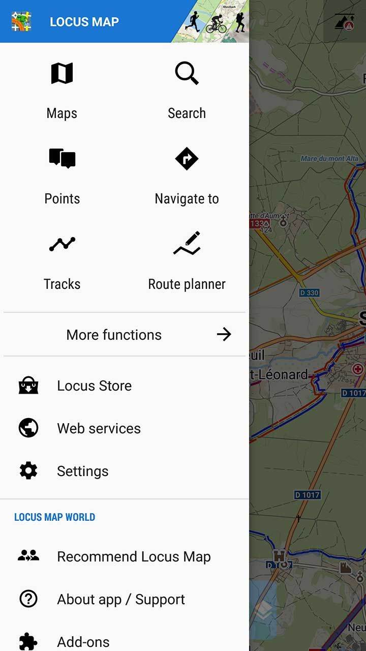
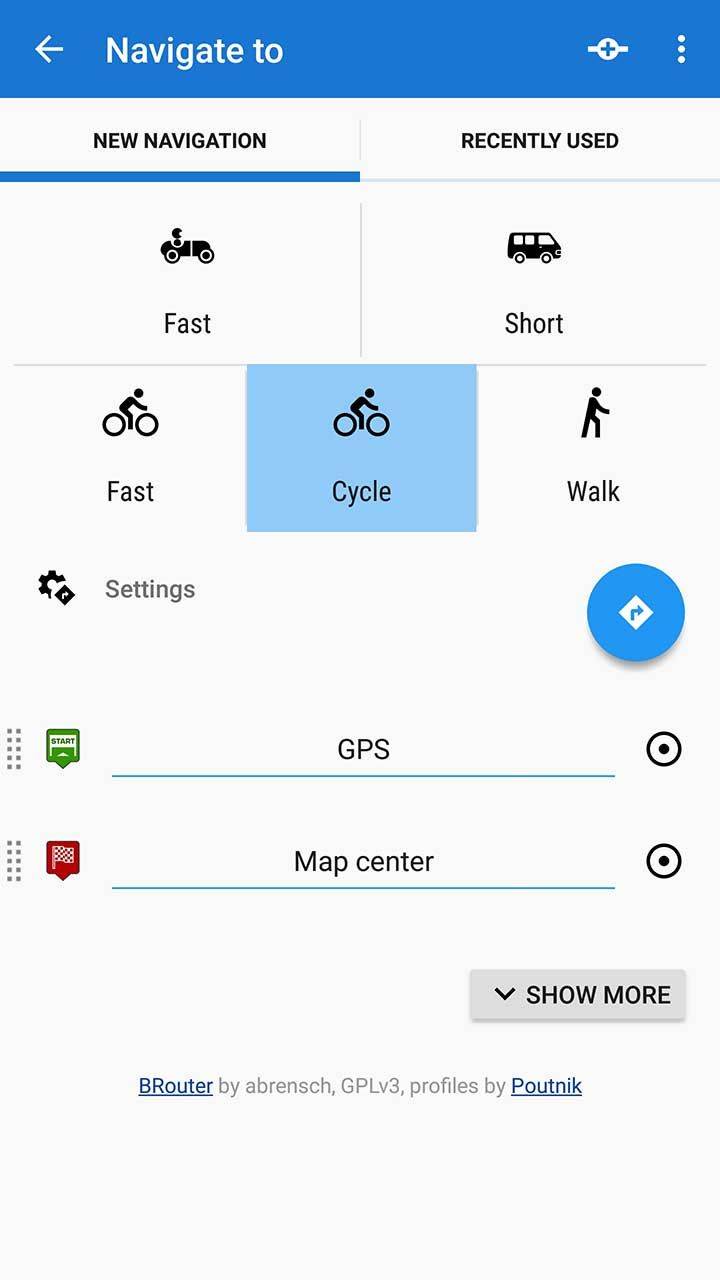
willing to assist if you care. if you wish to lear how to go thru, let's start a new thread
1. install on an Android device
2. display the sidebar menu (pic1 below, may or may not look like your setup. Post yours
3. click navigate to (pic 2)
4. specify beginning and end (pic 3)
5. click on te direction icon (right angle arrow in blue dot)
You should be good to go.
Once you get past the "hello world" stage, spend some time looking at the (numerous) settings. And adapt them to your preferences.
Possibly a good idea to download a map of your area.
Eventually, install bRouter such that you'll be able to compute a route offline (I do not mean a map. I mean a computed route).
Eventually design your navigation screen with custom overlay that'll display whatever sensor you've paired.
(sorry if the pics are HUGE. tried to resize but the uploader insists on creating poster-size images

Last edited by gauvins; 12-03-18 at 11:17 PM.
12-03-18, 11:54 PM
#19
Slow Rider

I use Locus pro and find it excellent. I don't use it to navigate, but that function is there and works well. Importing routes is easy. I use Gaiagps.com to create routes and then upload GPX files to Google Drive, then open GPX from Drive into Locus.
For navigation, I prefer Copilot - works very well for both auto and bike when needed.
For navigation, I prefer Copilot - works very well for both auto and bike when needed.
12-05-18, 04:01 PM
#20

Senior Member
Join Date: Oct 2012
Location: Twin Cities, Minnesota, USA
Posts: 1,257
Bikes: 2017 Salsa Carbon Mukluk frame built with XT, 2018 Kona Rove NRB build with Sram Apex 1,2008 Salsa El Mariachi, 1986 Centurion Ironman
Mentioned: 11 Post(s)
Tagged: 0 Thread(s)
Quoted: 286 Post(s)
Liked 100 Times
in
65 Posts
Another vote for Locus
Osmand is also excellent.
12-06-18, 08:03 AM
#21
Senior Member
Join Date: Apr 2016
Location: Ontario
Posts: 558
Bikes: HP Velotechnik Streetmachine GTE, 2015 Devinci Silverstone SL4, 2012 Cannondale Road Tandem 2, Circe Morpheus, 2021 Rose Backroad, 2017 Devinci Hatchet
Mentioned: 5 Post(s)
Tagged: 0 Thread(s)
Quoted: 181 Post(s)
Liked 14 Times
in
12 Posts
I know of people who plan with Strava's routing feature (because it routes based on their heatmaps!) and download the GPX files in order to route on their favourite routing app (Osmand, Orux, etc.)
12-06-18, 08:21 AM
#22
don't try this at home.

Join Date: Jan 2006
Location: N. KY
Posts: 5,931
Mentioned: 10 Post(s)
Tagged: 0 Thread(s)
Quoted: 972 Post(s)
Liked 509 Times
in
349 Posts
The comments here are about two different routing methods:
1. set a starting location and and ending location. Let the software create the route.
This is easy on a tablet or phone, but "your results may vary".
osmand+ will do this quite easily. But I don't use it for this purpose. It's going to just pick the shortest route.
I really like osmand+ for a quick look at my current location when I'm out riding or walking. It launches in a few seconds, and the maps are stored in the phone or tablet. So I just need a GPS signal. Switching map styles from "driving" to "biking" or "walking" changes the map details. "Walking" shows trails and roads. Zooming in gives more local detail.
Heat Maps
example: strava heat map for the Asheville NC area. Click "bike" and click "Labels" on the sidebar.
The reviews say that newer Garmins use Garmin's "heat map", to route based on which roads are popular (from uploaded Garmin Connect recordings). The Strava Route Builder was the first of this type, and it often makes a very good route from just a starting and ending point, sometimes routing way off the obvious, shortest route.
So a heat map based route would likely be at least reasonable without having to edit it too much.
2. design / adjust a route. I use ridewithgps.com or strava route builder. This is difficult without a mouse. I mostly use ridewithgps.com, and sometimes Strava Route Builder for routes in unfamiliar areas. These need an internet connection and a mouse pointer.
I'll review the elevation chart as the route gets created, and often use Street View or Satellite View to check out a road. I'll Undo/Redo, or drag the route to a different road. This would be frustrating on a tablet using my finger. Even with Strava Route Builder, the viewable heat map shows alternate route choices that are just as rideable as the automatic route, so I often edit the route to go near an area I want to visit.
Last edited by rm -rf; 12-06-18 at 08:29 AM.
12-08-18, 09:56 AM
#23
Senior Member
Join Date: Sep 2013
Location: NE Oklahoma (*really* NE)
Posts: 108
Bikes: 1985 Raleigh Portage, 1976 Araya commuter (yes, they make frames)
Mentioned: 0 Post(s)
Tagged: 0 Thread(s)
Quoted: 42 Post(s)
Likes: 0
Liked 7 Times
in
5 Posts
+1 for Maps.me. You can download large offline maps and create routes without an internet connection. The only feature I wish it offered is a GoogleMaps-like presentation of 2 or 3 routes to choose between.
Also, I think some android tablets will allow you to plug a wireless mouse receiver into the USB port, which could make routing work a bit easier.
Finally, this thread reinforces to me the value of having other route-building skills and resources than an electronic routing tool when on tour, particularly if you want to take smaller side roads. There's only so much you can expect from routing algorithms and limited screen space.
12-08-18, 12:40 PM
#24
Senior Member
+1 for Maps.me. You can download large offline maps and create routes without an internet connection. The only feature I wish it offered is a GoogleMaps-like presentation of 2 or 3 routes to choose between.
Also, I think some android tablets will allow you to plug a wireless mouse receiver into the USB port, which could make routing work a bit easier.
Finally, this thread reinforces to me the value of having other route-building skills and resources than an electronic routing tool when on tour, particularly if you want to take smaller side roads. There's only so much you can expect from routing algorithms and limited screen space.
Also, I think some android tablets will allow you to plug a wireless mouse receiver into the USB port, which could make routing work a bit easier.
Finally, this thread reinforces to me the value of having other route-building skills and resources than an electronic routing tool when on tour, particularly if you want to take smaller side roads. There's only so much you can expect from routing algorithms and limited screen space.


