


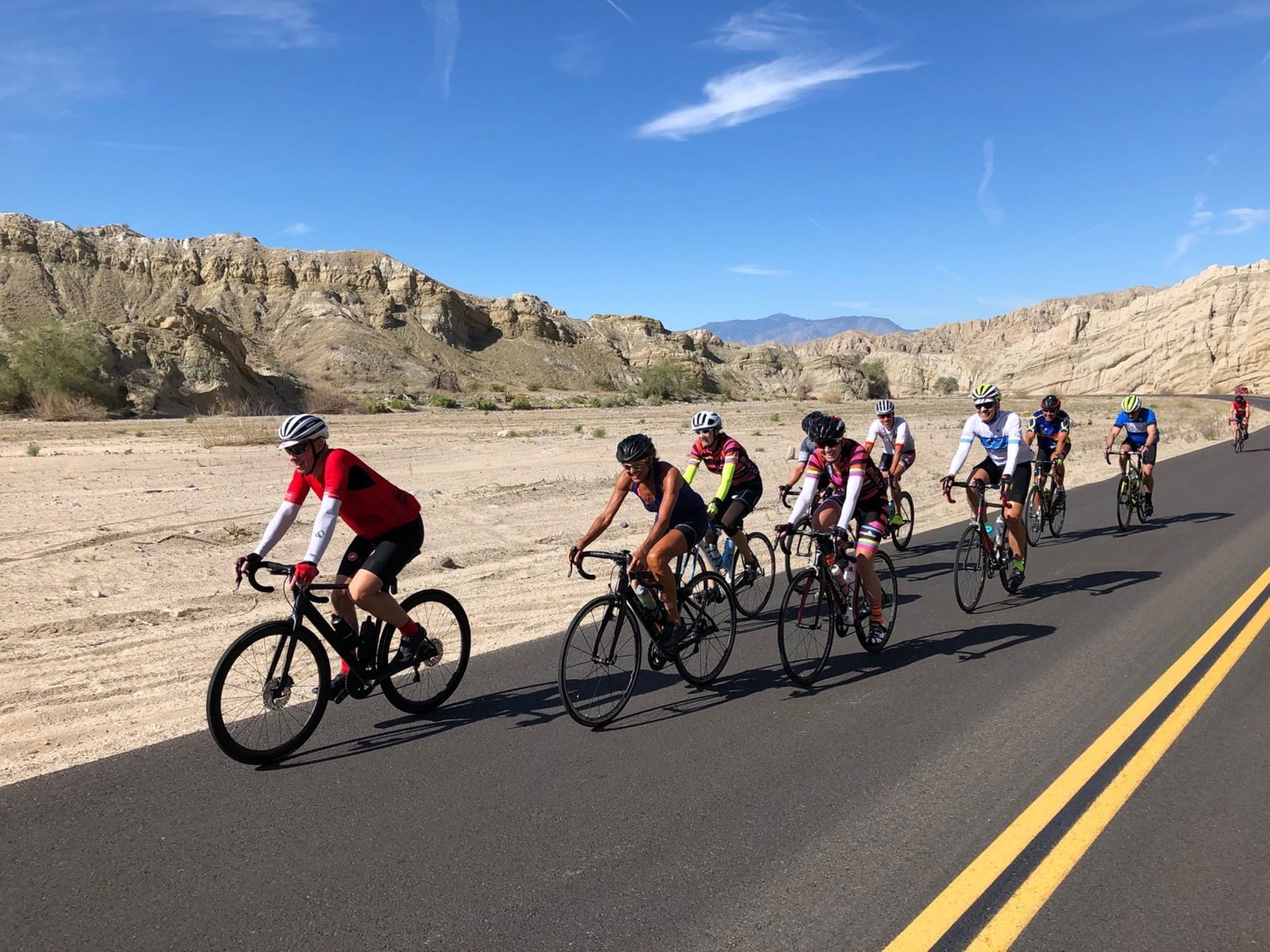
Palm Springs riding... Access to gated communities.
 03-01-20, 10:24 PM
#1
Junior Member
Thread Starter
Palm Springs riding... Access to gated communities.
I'm sure this subject has been broached before..... The riding in that area isn't great, as far as I can see, when most of the riding available is on the main roads, because most of the side roads are private communities or exclusive country clubs.
What I wanted to know was
have any of you contacted any of the gated communities (ones that go through to another safer street (like from Date Palm to Cathedral Canyon rd, eg), and have asked passage so that you might not get killed on something less safe (plenty to choose from). If so, what reaction have you gotten?
How bout if you rolled up to a gated community and just asked passage from the security people?
Going to be in PS for a week, and want to get my share of riding in, without having to deal with the "LA styled street system" , there.
I'm going to call a couple of them near where I'm staying. Wish me luck. Give me feedback too. Would like to hear your stories.
 03-02-20, 03:21 AM
#2
velo-dilettante
Join Date: Apr 2009
Location: insane diego, california
Posts: 8,316
Bikes: 85 pinarello treviso steel, 88 nishiki olympic steel. 95 look kg 131 carbon, 11 trek madone 5.2 carbon
Mentioned: 26 Post(s)
Tagged: 0 Thread(s)
Quoted: 1628 Post(s)
Liked 3,114 Times
in
1,683 Posts
lived out there for a year in the late 80's and visited family out there twice a month for twenty years. can't think of a single country club
in the coachella valley i'd rather ride through than past or around. most of the ones i went into had plenty of speedbumps (may be
speedhumps now) and narrow streets to slow/calm traffic.
there are a ton of bike lanes in the valley. the speed limits (for the most part) in the actual town of palm springs are the lowest in the valley.
once into cathedral city and points eastward, nearly every arterial street is 45 (or more) mph.
a couple of rides to consider:
1. climbing tram road from palm springs. quite the workout. go as far as the legs will allow. just watch that speed on the descent. once back
down to the base of the climb, hang a left (north) on hwy 111 and spin into a usual headwind for a few scenic miles till the junction with the 10
freeway, turn around and blast into town with the generous (now) tailwind.
2. old palm springs homes tour...quiet, scenic roads west of hwy 111 and at the base of the mountains in town. mostly flat except for close to the tram road area.
the movie colony area on the other side to hwy 111 is worthy of rolling thru as well.
3. la quinta cove if you're actually on the other end of the coachella valley. a little climb but scenic and easy to do a loop or three. tends to be shielded from the wind
fairly well if the winds are out in force.
4. box canyon road from mecca up to the 10 freeway and possibly beyond, heading into the southern entrance of joshua tree national park.
box canyon road was messed up due to flooding but i have it on good authority that it's been repaired and good to go. low traffic and scenic.
an easy, gradual climb/descent.
5. 1000 palms road...accessible from ramon road coming from palm springs/cathedral city/rancho mirage or from washington road coming from indian wells. ramon eventually
turns into washington and vice versa. near the high point of both is the turnoff for 1000 palms road. low traffic and pretty. eventually climbs up to sky valley road. a left takes you to
desert hot springs and palm springs. a right takes you to indio. either way will be about a 40 mile loop.
6. hwy 74 heading south from palm desert into the mountains...hwy 74 is a decent little climb for a few miles from its' intersection with hwy 111. once you pass the bighorn country
club and the parking turnout for the art smith hiking trail, the road ramps up and noticeably gets crazy squiggly. not the safest road to (especially) ascend once the curves attack
but people do it up to vista point or the sugarloaf cafe/fire station or farther. many of the sightlines for rear-approaching vehicles are not good. all that said, it is a siren song for desert riders.
rear (and front) blinkers on this stretch will be worth their weight in gold and hi-viz clothing won't hurt either. i'm not recommending it, just informing you of it since it pops out
on even the most casual map appraisal of the area.
7. riding hwy 111 to/from palm springs...yes, on paper, this is the most direct way to many of the desert communities. traffic will be heaviest on this road and there are a ton of stoplights.
bike lanes on both sides of the highway and the road is fairly wide from palm springs to indio except for the two-mile stretch through cathedral city.
Last edited by diphthong; 03-02-20 at 03:26 AM.
03-02-20, 08:21 AM
#3
Pennylane Splitter
Join Date: Sep 2012
Location: Orange County, California
Posts: 1,879
Bikes: Yes
Mentioned: 14 Post(s)
Tagged: 0 Thread(s)
Quoted: 1802 Post(s)
Liked 1,439 Times
in
989 Posts
Expect them to say no. The residents pay for the security, and usually pay to maintain the streets/property inside the gated area, so they call the shots (through their HOA). There's plenty of nice roads in Palm Springs & the rest of the Coachella Valley, you just have to do your part and pay attention to traffic. IF you're too paranoid of the traffic, get a membership at a national gym and use the indoor cycle trainers at their location while you're out there.
03-02-20, 12:53 PM
#4
Junior Member
Thread Starter
Thanks!
Thanks O-B and skidder. I figured that I might run into roadblocks with gated communities. I called one this morning, and found out what you said... you have to go through the HOA (17 individual ones per the location I wanted to go through... I do like to have a workout, and getting caught up in speed humps, etc might slow me down) The first time around, I didn't do my homework, and ended up routing through a bunch of them, of course, getting stymied each time I turned into one, trying to avoid narrow, car-centric roads, like Ramon, or De Valle, especially when I tried to go from the middle of PS to the Sprouts in La Quinta, and back. I was quite frustrated. This time around, I'm using maps to see which parts have been traced, and the wideness of the roads, so that cars and bikes can coexist. I think I'll do better this time.
O-B: I knew you'd come up with a number of suggested routes. Time to go back to rwgps, and map them out. I've done Tramway, the only time I was there with a bike. Strange that you are stopped at the parking lot entrance.... Safety reasons, so they say. I think they should outlaw cars, too. I'm also going to try the route that leads through the Living Desert as well. I seek out hills.
O-B: I knew you'd come up with a number of suggested routes. Time to go back to rwgps, and map them out. I've done Tramway, the only time I was there with a bike. Strange that you are stopped at the parking lot entrance.... Safety reasons, so they say. I think they should outlaw cars, too. I'm also going to try the route that leads through the Living Desert as well. I seek out hills.
03-03-20, 10:05 AM
#5
velo-dilettante
Join Date: Apr 2009
Location: insane diego, california
Posts: 8,316
Bikes: 85 pinarello treviso steel, 88 nishiki olympic steel. 95 look kg 131 carbon, 11 trek madone 5.2 carbon
Mentioned: 26 Post(s)
Tagged: 0 Thread(s)
Quoted: 1628 Post(s)
Liked 3,114 Times
in
1,683 Posts
^the closed (to bikes!) portion of tram road is ridiculously steep and hard and makes what you just slogged through seem flat. be very very thankful it's now closed to cyclists. had a 40+mph wipeout descending that now closed top part maybe 15 years ago. i miss that stretch but i don't if ya know what i mean.
a quick and dirty climb close to many of the desert communities is the bangin’ climb up to the ritz-carlton hotel at the very end of frank sinatra drive in rancho mirage. starts heading uphill as soon as you pass highway 111. it’ll raise your heart rate.
there are a few decent, short climbs in that little area west of hwy 111 (palm canyon rd) and south of tram road that take advantage of the same alluvial fan that makes tram road so difficult. nothing too crazy but adds a little spice.
Last edited by diphthong; 03-04-20 at 04:44 AM.
03-04-20, 04:54 AM
#6
velo-dilettante
Join Date: Apr 2009
Location: insane diego, california
Posts: 8,316
Bikes: 85 pinarello treviso steel, 88 nishiki olympic steel. 95 look kg 131 carbon, 11 trek madone 5.2 carbon
Mentioned: 26 Post(s)
Tagged: 0 Thread(s)
Quoted: 1628 Post(s)
Liked 3,114 Times
in
1,683 Posts
Thanks O-B and skidder. I figured that I might run into roadblocks with gated communities. I called one this morning, and found out what you said... you have to go through the HOA (17 individual ones per the location I wanted to go through... I do like to have a workout, and getting caught up in speed humps, etc might slow me down) The first time around, I didn't do my homework, and ended up routing through a bunch of them, of course, getting stymied each time I turned into one, trying to avoid narrow, car-centric roads, like Ramon, or De Valle, especially when I tried to go from the middle of PS to the Sprouts in La Quinta, and back. I was quite frustrated. This time around, I'm using maps to see which parts have been traced, and the wideness of the roads, so that cars and bikes can coexist. I think I'll do better this time.
O-B: I knew you'd come up with a number of suggested routes. Time to go back to rwgps, and map them out. I've done Tramway, the only time I was there with a bike. Strange that you are stopped at the parking lot entrance.... Safety reasons, so they say. I think they should outlaw cars, too. I'm also going to try the route that leads through the Living Desert as well. I seek out hills.
O-B: I knew you'd come up with a number of suggested routes. Time to go back to rwgps, and map them out. I've done Tramway, the only time I was there with a bike. Strange that you are stopped at the parking lot entrance.... Safety reasons, so they say. I think they should outlaw cars, too. I'm also going to try the route that leads through the Living Desert as well. I seek out hills.
you may be better off just doing repeats on hwy 74 south of hwy 111 as far up the hill as you feel comfy. bike lane up to the previously mentioned squiggly part.
after that, there's zero shoulder with only a few turnouts and bleepy sightlines all the way until two miles east of the hwy 74/hwy 371 junction.
lots of commuting traffic to/from temecula area before 9am and after 2pm. if you're curious about riding the squiggly parts of hwy 74, i recommend driving it first to verify your comfort levels
potentially riding it.
if you're looking for a nearby, longish climb...i'd pick the 243 from the beaumont area heading up to idyllwild vs hwy 74. less traffic and slightly better sightlines. it's about a 25 min drive from cat city/palm springs.
there's also the oak glen climb north of banning (also about a 25 min drive away). from the top of oak glen, you can easily access damnation alley up to forest falls via hwy 38.
Last edited by diphthong; 03-04-20 at 05:05 AM.
03-05-20, 10:04 PM
#7
Senior Member

As ooga-booga mentioned if you want to climb 74 do it very early on Saturday or Sunday AM (try to start at first light). Any later than that and you'll have to deal with cars, trucks and the occasional RV on a winding road with no shoulder in many areas.
The typical destination is the Sugarloaf Cafe/Fire Station in Mountain Center. It's about 15 miles if starting at Hwy 111 in Palm Desert. If you make the climb, at about mile 12 there's a neat detour for a bit more climbing. Turn right at Carrizo Rd and climb about 1 1/2 miles to Pinyon Crest Dr then u turn to go back to Hwy 74 and continue another 3 miles to the destination. It's possible to continue further and I have friends that regularly continue on to Lake Hemet (I haven't done that myself).
Edit: What town will you be staying at?
Last edited by tunavic; 03-05-20 at 10:07 PM. Reason: add a question
03-06-20, 07:27 PM
#8
Senior Member
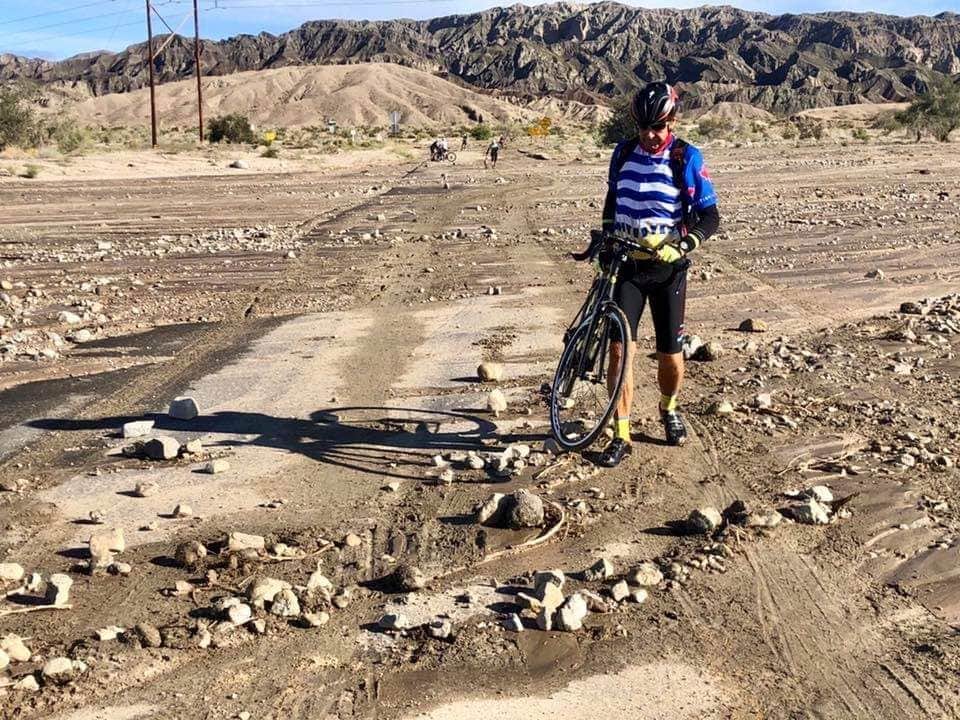
Some friends did a ride today to Box Canyon. I copied their route from Strava
https://www.strava.com/routes/24246856
ooga-booga Here's a look at the pave on Box Canyon.
https://www.strava.com/routes/24246856
ooga-booga Here's a look at the pave on Box Canyon.
03-07-20, 05:35 AM
#9
velo-dilettante
Join Date: Apr 2009
Location: insane diego, california
Posts: 8,316
Bikes: 85 pinarello treviso steel, 88 nishiki olympic steel. 95 look kg 131 carbon, 11 trek madone 5.2 carbon
Mentioned: 26 Post(s)
Tagged: 0 Thread(s)
Quoted: 1628 Post(s)
Liked 3,114 Times
in
1,683 Posts
Some friends did a ride today to Box Canyon. I copied their route from Strava
https://www.strava.com/routes/24246856
ooga-booga Here's a look at the pave on Box Canyon.
https://www.strava.com/routes/24246856
ooga-booga Here's a look at the pave on Box Canyon.
like yerba buena with new asphalt in the santa monicas, it makes all the difference in the world. can't wait to hit it. thanks for the pic!
03-07-20, 12:22 PM
#10
Senior Member
It was completely washed away by heavy rains in fall 2018 and they closed it for a year while rebuilding.
03-08-20, 09:02 AM
#11
Junior Member
Thread Starter
As ooga-booga mentioned if you want to climb 74 do it very early on Saturday or Sunday AM (try to start at first light). Any later than that and you'll have to deal with cars, trucks and the occasional RV on a winding road with no shoulder in many areas.
The typical destination is the Sugarloaf Cafe/Fire Station in Mountain Center. It's about 15 miles if starting at Hwy 111 in Palm Desert. If you make the climb, at about mile 12 there's a neat detour for a bit more climbing. Turn right at Carrizo Rd and climb about 1 1/2 miles to Pinyon Crest Dr then u turn to go back to Hwy 74 and continue another 3 miles to the destination. It's possible to continue further and I have friends that regularly continue on to Lake Hemet (I haven't done that myself).
Edit: What town will you be staying at?
The typical destination is the Sugarloaf Cafe/Fire Station in Mountain Center. It's about 15 miles if starting at Hwy 111 in Palm Desert. If you make the climb, at about mile 12 there's a neat detour for a bit more climbing. Turn right at Carrizo Rd and climb about 1 1/2 miles to Pinyon Crest Dr then u turn to go back to Hwy 74 and continue another 3 miles to the destination. It's possible to continue further and I have friends that regularly continue on to Lake Hemet (I haven't done that myself).
Edit: What town will you be staying at?
03-08-20, 09:19 AM
#12
Junior Member
Thread Starter
I did trace routes better this time around, using gMaps. Found out that that the bike travel in Rancho Mirage (Frank Sinatra, Bob Hope) and Palm Desert ( are FAR better than Cathedral City (the only place I found calming roads was the Cove)...Trying to go N towards PS, by way of Dinah Shore, Ramon, Vista Chino is for the birds, and you have limited options because of all the country clubs and private community access (I did call one of them... she was at least nice about it, but wasn't the right person to talk to... Mentioned speed bumps and some congested traffic, and limited options, especially on gates that were automatic, without security there. There was one, that I had to laugh at. It was at the top of Frank Sinatra (I did go up that climb... twice), , circled around the guard shack at the top. The guy was going to come out and chase me off. I just laughed at him. There are some that would benefit cyclists if they were allowed access, because it can be dangerous trying to get anywhere.
To circumvent 111 (which I never went on), I accessed a "trail" near where I was staying. It was nearly dirt (chunks of asphalt) cordoned off by a fence, and flooded in parts, bumpy in others. It also traced a golf course, where you could possibly get hit by an errant shot. It eventually led it's way to Golf Club dr (from Cath Cyn) I went the other way home. (DS, DP) Faster, though more dangerous. That'll be the only time I take that path. I think it was put there in the 60s. Maybe, one way to allow some sort of access other than the main roads.
To circumvent 111 (which I never went on), I accessed a "trail" near where I was staying. It was nearly dirt (chunks of asphalt) cordoned off by a fence, and flooded in parts, bumpy in others. It also traced a golf course, where you could possibly get hit by an errant shot. It eventually led it's way to Golf Club dr (from Cath Cyn) I went the other way home. (DS, DP) Faster, though more dangerous. That'll be the only time I take that path. I think it was put there in the 60s. Maybe, one way to allow some sort of access other than the main roads.
03-08-20, 11:01 AM
#13
Senior Member
I did trace routes better this time around, using gMaps. Found out that that the bike travel in Rancho Mirage (Frank Sinatra, Bob Hope) and Palm Desert ( are FAR better than Cathedral City (the only place I found calming roads was the Cove)...Trying to go N towards PS, by way of Dinah Shore, Ramon, Vista Chino is for the birds, and you have limited options because of all the country clubs and private community access (I did call one of them... she was at least nice about it, but wasn't the right person to talk to... Mentioned speed bumps and some congested traffic, and limited options, especially on gates that were automatic, without security there. There was one, that I had to laugh at. It was at the top of Frank Sinatra (I did go up that climb... twice), , circled around the guard shack at the top. The guy was going to come out and chase me off. I just laughed at him. There are some that would benefit cyclists if they were allowed access, because it can be dangerous trying to get anywhere.
To circumvent 111 (which I never went on), I accessed a "trail" near where I was staying. It was nearly dirt (chunks of asphalt) cordoned off by a fence, and flooded in parts, bumpy in others. It also traced a golf course, where you could possibly get hit by an errant shot. It eventually led it's way to Golf Club dr (from Cath Cyn) I went the other way home. (DS, DP) Faster, though more dangerous. That'll be the only time I take that path. I think it was put there in the 60s. Maybe, one way to allow some sort of access other than the main roads.
To circumvent 111 (which I never went on), I accessed a "trail" near where I was staying. It was nearly dirt (chunks of asphalt) cordoned off by a fence, and flooded in parts, bumpy in others. It also traced a golf course, where you could possibly get hit by an errant shot. It eventually led it's way to Golf Club dr (from Cath Cyn) I went the other way home. (DS, DP) Faster, though more dangerous. That'll be the only time I take that path. I think it was put there in the 60s. Maybe, one way to allow some sort of access other than the main roads.
Going to Palm Springs from Cat City is always a challenge. We typically stay off Dinah Shore other than early on a weekend (the bridge is edgy). For your next visit, use Da Vall north to 30th Ave then turn right at Landau Blvd to Vista Chino (this portion of Vista Chino is less than ideal but was paved about 2 years ago and has a wide bike lane all they was to the wash). Left at Vista Chino and then Via Escuela to Caballeros into the downtown area. See here: https://ridewithgps.com/routes/32086331
Another option is turn right on Caballeros instead of left and go north to E San Rafael make a left and that will take you right to Tramway Road for a nice climb.
03-08-20, 11:33 AM
#14
Junior Member
Thread Starter
Going to Palm Springs from Cat City is always a challenge. We typically stay off Dinah Shore other than early on a weekend (the bridge is edgy). For your next visit, use Da Vall north to 30th Ave then turn right at Landau Blvd to Vista Chino (this portion of Vista Chino is less than ideal but was paved about 2 years ago and has a wide bike lane all they was to the wash). Left at Vista Chino and then Via Escuela to Caballeros into the downtown area. See here: https://ridewithgps.com/routes/32086331
Another option is turn right on Caballeros instead of left and go north to E San Rafael make a left and that will take you right to Tramway Road for a nice climb.
03-08-20, 11:59 PM
#15
velo-dilettante
Join Date: Apr 2009
Location: insane diego, california
Posts: 8,316
Bikes: 85 pinarello treviso steel, 88 nishiki olympic steel. 95 look kg 131 carbon, 11 trek madone 5.2 carbon
Mentioned: 26 Post(s)
Tagged: 0 Thread(s)
Quoted: 1628 Post(s)
Liked 3,114 Times
in
1,683 Posts
i started riding in 2000 and hit that soon after and it was bleepy then. guessing it was late 80's. be berry berry curious tho. not interwebs savvy enuff to dredge up that kinda info. curious tho.
03-09-20, 02:44 AM
#16
velo-dilettante
Join Date: Apr 2009
Location: insane diego, california
Posts: 8,316
Bikes: 85 pinarello treviso steel, 88 nishiki olympic steel. 95 look kg 131 carbon, 11 trek madone 5.2 carbon
Mentioned: 26 Post(s)
Tagged: 0 Thread(s)
Quoted: 1628 Post(s)
Liked 3,114 Times
in
1,683 Posts
I was in Cathedral City, off Date Palm, near Perez. I did try 74 on a Friday morning. I did go past the Art Smith TH. I did a few short repeats at the Center, across the road, then thought, "I haven't had enough yet", so I continued up. A couple of longish trucks went by me, at speeds, but they gave me *some space* (hard to do when they're 30 and 40' long) Yes, the shoulder gets nonexistent, but I just go in the lane or get myself visible. We did drive that on the way home. Yes, looks narrow, but the suggestion to do it early on a weekend, is a great idea, right at sunrise, or Civil/Nautical Twilight times. If you know Latigo rd, in the Santa Monica Mountains, that's what it seems to remind me of (10 miles of twisty turns, from zero to 2400'). I don't know how many have done a trip from there to San Diego, but it seems like it's do-able, though when we went home, we turned right towards Temecula, not towards Warner Springs, which is what I'd do on a bike.
extremely concentrated with really really poor sightlines for vehicles (especially just below the lower and bigger vista point). latigo has residences along the route and lower posted speeds. hwy 74 doesn't have residences/driveways along the route until 2.5 miles up the road from vista point.
latigo is calm(ed). hwy 74 south (and uphill) of the art smith trail is just not. if climbing hwy 74 with another or a group, it's better to be at the front vs the back.
Last edited by diphthong; 03-09-20 at 02:50 AM.
03-10-20, 10:08 AM
#17
Senior Member
03-13-20, 02:09 PM
#18
Senior Member

Last edited by tunavic; 03-14-20 at 03:16 PM.
03-13-20, 05:46 PM
#19
velo-dilettante
Join Date: Apr 2009
Location: insane diego, california
Posts: 8,316
Bikes: 85 pinarello treviso steel, 88 nishiki olympic steel. 95 look kg 131 carbon, 11 trek madone 5.2 carbon
Mentioned: 26 Post(s)
Tagged: 0 Thread(s)
Quoted: 1628 Post(s)
Liked 3,114 Times
in
1,683 Posts
yikes! that's about what i expected tho. thanks for the update. looks like more rain in the forecast nexrt week as well. may hafta wait till april to ride it cleanly.
05-06-20, 04:01 AM
#20
Junior Member
Join Date: Apr 2020
Posts: 12
Mentioned: 0 Post(s)
Tagged: 0 Thread(s)
Quoted: 5 Post(s)
Likes: 0
Liked 4 Times
in
4 Posts
6. hwy 74 heading south from palm desert into the mountains...hwy 74 is a decent little climb for a few miles from its' intersection with hwy 111. once you pass the bighorn country
club and the parking turnout for the art smith hiking trail, the road ramps up and noticeably gets crazy squiggly. not the safest road to (especially) ascend once the curves attack
but people do it up to vista point or the sugarloaf cafe/fire station or farther. many of the sightlines for rear-approaching vehicles are not good. all that said, it is a siren song for desert riders.
rear (and front) blinkers on this stretch will be worth their weight in gold and hi-viz clothing won't hurt either. i'm not recommending it, just informing you of it since it pops out
on even the most casual map appraisal of the area.
.
Saw a number of riders going up hwy 74 this weekend. I would love to try it some day but is seems so dangerous and sketchy but that descend must be such a rush.
Likes For Orion760@:
05-06-20, 09:56 PM
#21
velo-dilettante
Join Date: Apr 2009
Location: insane diego, california
Posts: 8,316
Bikes: 85 pinarello treviso steel, 88 nishiki olympic steel. 95 look kg 131 carbon, 11 trek madone 5.2 carbon
Mentioned: 26 Post(s)
Tagged: 0 Thread(s)
Quoted: 1628 Post(s)
Liked 3,114 Times
in
1,683 Posts
ascent (if you must) recommended with a group of 3+. dirty little secret...try not to be the last of the group. descent is bomb from the sugarloaf cafe and even higher up from the 371/74 intersection.
there are a couple of tight corners on the descent below the vista point/palm desert overlook so be careful.
if you're lucky...you can wait, then pull out and descend ahead of an rv and have the descent all to yourself since the rv won't pass you unless you're going molasses slow downhill.
can always do a car shuttle for the descent...
