


Inclinometers
 09-27-18, 12:03 PM
#1
Newbie
Thread Starter
Join Date: Apr 2009
Location: ...
Posts: 42
Bikes: Giant ARX2...
Mentioned: 0 Post(s)
Tagged: 0 Thread(s)
Quoted: 6 Post(s)
Liked 0 Times
in
0 Posts
Inclinometers
I have been searching for hill challenges and I'm interested in a simple inclinometer.
I found this:
Link: https://a.co/d/dAEE3JO
and
https://play.google.com/store/apps/d...inometer&hl=en
I'm leaning towards the app, cause I don't need to see the inclinometer every time I ride. Its only for new challenges that I want to reference.
Any comments, suggestions? Thanks
I found this:
Link: https://a.co/d/dAEE3JO
and
https://play.google.com/store/apps/d...inometer&hl=en
I'm leaning towards the app, cause I don't need to see the inclinometer every time I ride. Its only for new challenges that I want to reference.
Any comments, suggestions? Thanks
 09-27-18, 12:26 PM
#2

I am potato.

Join Date: Jun 2015
Location: Pacific Northwest
Posts: 3,116
Bikes: Only precision built, custom high performance elitist machines of the highest caliber. 🍆
Mentioned: 29 Post(s)
Tagged: 0 Thread(s)
Quoted: 1789 Post(s)
Liked 1,629 Times
in
933 Posts
Ride with GPS has a hill finder option in their route planning. It tells you biggest, steepest longest. Descents too.
If you've got a Garmin, %grade is an option for your data screen.
I didn't click on your links, but This is my 2 cents anyway.
If you've got a Garmin, %grade is an option for your data screen.
I didn't click on your links, but This is my 2 cents anyway.
09-27-18, 12:47 PM
#3
Senior Member
Join Date: Sep 2005
Location: Michigan
Posts: 3,706
Bikes: Trek 730 (quad), 720 & 830, Bike Friday NWT, Brompton M36R & M6R, Dahon HAT060 & HT060, ...
Mentioned: 10 Post(s)
Tagged: 0 Thread(s)
Quoted: 840 Post(s)
Liked 336 Times
in
251 Posts
I have the Sky Mounti one:
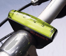
It is OK. A bit slow adjusting, but this is presumably needed to avoid erratic ups and downs. It works fine at low temperatures unlike some other liquid-filled instruments.
It is OK. A bit slow adjusting, but this is presumably needed to avoid erratic ups and downs. It works fine at low temperatures unlike some other liquid-filled instruments.
09-27-18, 02:20 PM
#4
Senior Member

Join Date: Feb 2008
Location: Peoria, IL
Posts: 4,476
Mentioned: 86 Post(s)
Tagged: 0 Thread(s)
Quoted: 1829 Post(s)
Liked 3,375 Times
in
1,580 Posts
I've got the Cline-ometer app on my apple device, and it's quite nice for making measurements of things in the shop and such. Definitely a nice tool for checking frame angles too. I hadn't considered using it when stopped on a slope or such, but it might work okay. The cost is certainly minimal.
I've also got a Sky-Mounti liquid inclination sensor/indicator. It takes a bit of effort to get it zero'ed out, but in terms of making continuous inclination measurements while riding, it works well. It does have the limitations that will be found on any device that senses the gravity vector... it will be affected by fore and aft accelerations. If you don't have a smooth pedaling style while climbing hills, the bubble will move in response.
There is always the option of stopping and checking the reading, such as I did on this 19% hill near St. Louis....
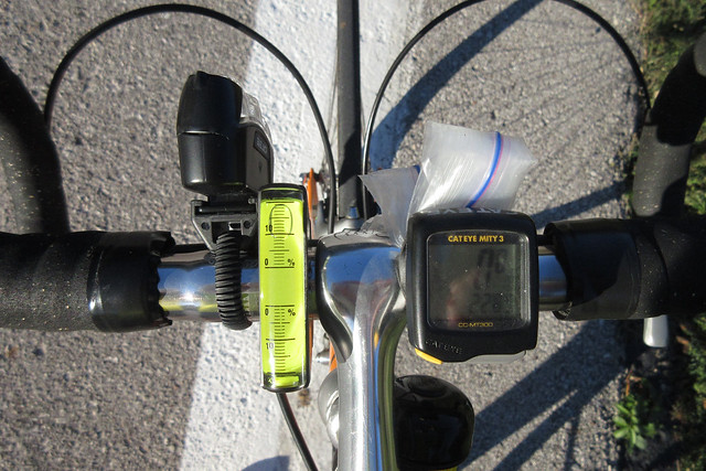
One limitation that might matter is that it only fits "traditional" round handlebars. ..or at least that is true of the ones that I own. I'd check the manufacturer's info if you are concerned about it.
Steve in Peoria
I've also got a Sky-Mounti liquid inclination sensor/indicator. It takes a bit of effort to get it zero'ed out, but in terms of making continuous inclination measurements while riding, it works well. It does have the limitations that will be found on any device that senses the gravity vector... it will be affected by fore and aft accelerations. If you don't have a smooth pedaling style while climbing hills, the bubble will move in response.
There is always the option of stopping and checking the reading, such as I did on this 19% hill near St. Louis....
One limitation that might matter is that it only fits "traditional" round handlebars. ..or at least that is true of the ones that I own. I'd check the manufacturer's info if you are concerned about it.
Steve in Peoria
09-27-18, 02:48 PM
#5
Senior Member
Join Date: Dec 2010
Location: northern Deep South
Posts: 8,903
Bikes: Fuji Touring, Novara Randonee
Mentioned: 36 Post(s)
Tagged: 0 Thread(s)
Quoted: 2604 Post(s)
Liked 1,931 Times
in
1,212 Posts
Zero'ing the Sky-Mounti is overrated. I left mine about 3 degrees off, and mentally adjusted, until I couldn't make it up one hill. It was maxed out, so I turned the bike around and measured 22 degrees.
That said, and inclinometer is rightly defined as a gadget. You don't need one, it doesn't really tell you anything significant, but it's fun to play with (and useful in silly arguments over who rode the steepest hill!).
That said, and inclinometer is rightly defined as a gadget. You don't need one, it doesn't really tell you anything significant, but it's fun to play with (and useful in silly arguments over who rode the steepest hill!).
09-27-18, 02:51 PM
#6
Newbie
Thread Starter
Join Date: Apr 2009
Location: ...
Posts: 42
Bikes: Giant ARX2...
Mentioned: 0 Post(s)
Tagged: 0 Thread(s)
Quoted: 6 Post(s)
Liked 0 Times
in
0 Posts
Those bubble type do appeal to my keep it simple philosophy. I just downloaded the following (plaincode): I've decided for the time being I can scout out the challenging hills and stop to measure. I think the continuous need to know is going to take me beyond my skill level as a rider. This is from someone who is contemplating going back to a flip phone. If I do that, then I'll liking get one of those handlebar bubble types.
Thanks all, those look like good ones.

Thanks all, those look like good ones.
Last edited by SuperRecord; 09-27-18 at 02:52 PM. Reason: more info
09-27-18, 02:58 PM
#7
Newbie
Thread Starter
Join Date: Apr 2009
Location: ...
Posts: 42
Bikes: Giant ARX2...
Mentioned: 0 Post(s)
Tagged: 0 Thread(s)
Quoted: 6 Post(s)
Liked 0 Times
in
0 Posts
Trust me, i am not interested in bragging rights. its purely for training purposes. i hope to tackle Mt. Washington in New Hampshire some time in the future. A dubious goal maybe, but since I cycle alone I like to gauge how much I've improved; and besides, doing the same hills over and over gets old.
09-27-18, 04:44 PM
#8
Senior Member
Join Date: Aug 2010
Location: Madison, WI
Posts: 11,204
Bikes: 1961 Ideor, 1966 Perfekt 3 Speed AB Hub, 1994 Bridgestone MB-6, 2006 Airnimal Joey, 2009 Thorn Sherpa, 2013 Thorn Nomad MkII, 2015 VO Pass Hunter, 2017 Lynskey Backroad, 2017 Raleigh Gran Prix, 1980s Bianchi Mixte on a trainer. Others are now gone.
Mentioned: 48 Post(s)
Tagged: 0 Thread(s)
Quoted: 3459 Post(s)
Liked 1,465 Times
in
1,143 Posts
You have to make sure that you are going at a constant speed when you take a reading. If you are slowing down or accelerating it will show an error. Or, if you are on a hill and come to a complete stop, that too would be accurate.
I have used the Ski Mounti one on a couple tours. It was interesting to see how steep the uphills were.
I have used the Ski Mounti one on a couple tours. It was interesting to see how steep the uphills were.
09-28-18, 10:47 AM
#10
aka Tom Reingold

Join Date: Jan 2009
Location: New York, NY, and High Falls, NY, USA
Posts: 40,502
Bikes: 1962 Rudge Sports, 1971 Raleigh Super Course, 1971 Raleigh Pro Track, 1974 Raleigh International, 1975 Viscount Fixie, 1982 McLean, 1996 Lemond (Ti), 2002 Burley Zydeco tandem
Mentioned: 511 Post(s)
Tagged: 0 Thread(s)
Quoted: 7348 Post(s)
Liked 2,465 Times
in
1,433 Posts
I had no idea people do this.
__________________
Tom Reingold, tom@noglider.com
New York City and High Falls, NY
Blogs: The Experienced Cyclist; noglider's ride blog
�When man invented the bicycle he reached the peak of his attainments.� � Elizabeth West, US author
Please email me rather than PM'ing me. Thanks.
Tom Reingold, tom@noglider.com
New York City and High Falls, NY
Blogs: The Experienced Cyclist; noglider's ride blog
�When man invented the bicycle he reached the peak of his attainments.� � Elizabeth West, US author
Please email me rather than PM'ing me. Thanks.
 09-29-18, 10:21 AM
#11
Senior Member
Join Date: Sep 2004
Location: Chicago area
Posts: 2,551
Bikes: Airborne "Carpe Diem", Motobecane "Mirage", Trek 6000, Strida 2, Dahon "Helios XL", Dahon "Mu XL", Tern "Verge S11i"
Mentioned: 23 Post(s)
Tagged: 0 Thread(s)
Quoted: 980 Post(s)
Liked 582 Times
in
399 Posts
It *is* capable of serving a purpose! I have a folding commuter bike with handlebars that rotate to fold and unfold. It's nice to be able to place the bars and the brake levers in the same position quickly and repeatedly. Likewise the headlight. The inclinometer facilitates this very effectively.
09-29-18, 11:09 AM
#12
Senior Member

I just purchased a new bike computer that has a hill gradient read out. I have no idea how it will work as I haven't gotten it yet but I'm hoping it will work well enough to satisfy my idle curiosity. For me I just like to know the steepness and / or length of the hill I'm about to tackle ( if only to provide something for general reference ). Not that I'd use it all that much but there are places I've ridden in the past that had me saying to myself, " Gee, I wish I knew this road had this killer hill before I tried to ride it". There's been a time or two when I was wishing I knew the degree of incline on a particularly steep section ( or a planned route ), just for curiosity sake ( and to save me from trying to kill myself. I like a good challenge but I'm not getting any younger if you catch my drift ).
As for planned rides, there is a website I used to have on my former computer that let you plan a route and then let you see the grade of the hills. It was a free site. Can't remember the address now. It used to show the % grade by color on the actual map as well as a graph under the map. A similar website is Mapometer but Mapometer doesn't have the color indicators on the actual map. While graphs are sometimes useful sometimes graphs can't always show a particular short section that is very steep unless you can expand the graph. Most websites won't let you expand a graph.
Anyway, thanks to all for the links to those cheap inclinometers. I doubt I'd use something like that on a regular basis but nice to have on those really hilly rides
Last edited by 01 CAt Man Do; 09-29-18 at 11:14 AM.
09-29-18, 02:28 PM
#13
Senior Member
Join Date: Aug 2010
Location: Madison, WI
Posts: 11,204
Bikes: 1961 Ideor, 1966 Perfekt 3 Speed AB Hub, 1994 Bridgestone MB-6, 2006 Airnimal Joey, 2009 Thorn Sherpa, 2013 Thorn Nomad MkII, 2015 VO Pass Hunter, 2017 Lynskey Backroad, 2017 Raleigh Gran Prix, 1980s Bianchi Mixte on a trainer. Others are now gone.
Mentioned: 48 Post(s)
Tagged: 0 Thread(s)
Quoted: 3459 Post(s)
Liked 1,465 Times
in
1,143 Posts
A friend of mine has a GPS that reads the percent grade. Sometimes we will be pedaling up a shallow hill and he will suddenly say - WOW, it is now 20 percent grade. GPS gives you horizontal location and vertical elevation, grade can be calculated from that (change of elevation divided by change of horizontal position), but the recreational grade GPS units we use can give you a lot of error when trying to calculate an instantaneous slope readout. On my GPS units I shut off the WAAS correction to save batteries, that cuts my accuracy by tens of feet for location. Elevation data from GPS units usually has double the error of the GPS horizontal position.
09-29-18, 07:05 PM
#14
Senior Member
Join Date: Sep 2004
Location: Chicago area
Posts: 2,551
Bikes: Airborne "Carpe Diem", Motobecane "Mirage", Trek 6000, Strida 2, Dahon "Helios XL", Dahon "Mu XL", Tern "Verge S11i"
Mentioned: 23 Post(s)
Tagged: 0 Thread(s)
Quoted: 980 Post(s)
Liked 582 Times
in
399 Posts

"Andros" stem allows the bars to be higher or lower, as needed.
09-29-18, 09:57 PM
#16
Senior Member

Join Date: Nov 2017
Location: Seattle
Posts: 1,955
Bikes: Specialized Roubaix, Canyon Inflite AL SLX, Ibis Ripley AF, Priority Continuum Onyx, Santana Vision, Kent Dual-Drive Tandem
Mentioned: 20 Post(s)
Tagged: 0 Thread(s)
Quoted: 873 Post(s)
Liked 726 Times
in
436 Posts
Garmins like my Edge 520 use a barometric pressure sensor to detect grade changes. It is more accurate and responsive than GPS. Even Strava defaults to trusting grades calculated from devices equipped with barometers rather than overriding it with their own elevation change calculations.
09-30-18, 03:30 AM
#17
Me duelen las nalgas
Join Date: Aug 2015
Location: Texas
Posts: 13,513
Bikes: Centurion Ironman, Trek 5900, Univega Via Carisma, Globe Carmel
Mentioned: 199 Post(s)
Tagged: 0 Thread(s)
Quoted: 4559 Post(s)
Liked 2,802 Times
in
1,800 Posts
I've used apps to check inclines. Turns out the existing data on maps is already correct. So I quit worrying about it, unless I happened across a hill that was too short and steep to be on any existing map data. Then I'll dig out the phone and fire up the inclinometer app. Two of my bikes have horizontal top tubes so it's easy. Just set the phone across the top tube and check the angle.
We have a few short, steep hills with double digit grades so I'll tackle those occasionally to test the legs and lungs. Most of our climbs are rollers that average only 2% overall. No real mountains here.
We have a few short, steep hills with double digit grades so I'll tackle those occasionally to test the legs and lungs. Most of our climbs are rollers that average only 2% overall. No real mountains here.
09-30-18, 08:09 AM
#18
Full Member
I sold my Sky Mounti because the movement of the bike made getting a reading difficult since the bubble would move.
09-30-18, 11:16 AM
#19
Senior Member
Join Date: Feb 2009
Posts: 210
Mentioned: 0 Post(s)
Tagged: 0 Thread(s)
Quoted: 24 Post(s)
Likes: 0
Liked 2 Times
in
2 Posts
If you don't have an inclinometer, you can just dismount, take a picture and measure it with a protractor. Don't tell anyone that you were just out of gas and couldn't climb any further. This climb is in Athens. Measures 12 degrees, or 21.2557%. Ouch!

Surprise: 21.3% is too steep for my 34x32 gear! Had to walk final bit.
Surprise: 21.3% is too steep for my 34x32 gear! Had to walk final bit.
09-30-18, 01:52 PM
#20
Senior Member
I just downloaded the free app and I don't see it as being useful. To be useful I would have to be able to calibrate it to zero at the angled position I have my phone in while mounted to my bike. Otherwise it's useless IMO as a cycling tool. Hopefully my bike computer ( that I'm still waiting for ) will not be the same way.
09-30-18, 01:56 PM
#21
Senior Member
Join Date: Sep 2008
Posts: 162
Mentioned: 2 Post(s)
Tagged: 0 Thread(s)
Quoted: 51 Post(s)
Likes: 0
Liked 2 Times
in
2 Posts
I just downloaded the free app and I don't see it as being useful. To be useful I would have to be able to calibrate it to zero at the angled position I have my phone in while mounted to my bike. Otherwise it's useless IMO as a cycling tool. Hopefully my bike computer ( that I'm still waiting for ) will not be the same way.
OTOH, calibrate it to zero, mount it , put bike level, and do the math on hills.
09-30-18, 01:58 PM
#22
Senior Member
My Wahoo Bolt has grade but I know it isn't instantaneously accurate. And you know what, when I'm riding up anything steep enough to want to know about I'm usually too focused on pedaling to look. And similarly on downhills, I'm focused on the road when I'm doing 30+ on a downhill. I mostly use it to look at the metrics after the ride.
09-30-18, 05:03 PM
#23
Senior Member
Found the calibration setting. You're right, it ain't happy messing with it when at an angle. Oh well, it is what it is. My phone mount sits at a 20� angle where I have it on my stem. I can either do the math or I could choose to mount it to the bars where I can adjust it to 0�. I'll just do the math since likely I'll only use it on the rare occasion when I know I'll have a known mammoth climb.
09-30-18, 08:28 PM
#24
Senior Member
Join Date: Mar 2010
Location: Seattle, WA
Posts: 23,208
Mentioned: 89 Post(s)
Tagged: 0 Thread(s)
Quoted: 18883 Post(s)
Liked 10,646 Times
in
6,054 Posts
I rode over Washington Pass from the valley floor yesterday, more than 4,000' of vert. Never looked at the grade. It was steepest on the way to Cutthroat, I wonder if I can figure that out retroactively.
12-13-18, 07:19 PM
#25
Newbie
Thread Starter
Join Date: Apr 2009
Location: ...
Posts: 42
Bikes: Giant ARX2...
Mentioned: 0 Post(s)
Tagged: 0 Thread(s)
Quoted: 6 Post(s)
Liked 0 Times
in
0 Posts
I now use maps.google.com by placing a marker at the start and finish and use the bicycle feature to cover routes that are not always proper roads. Then I use Rise/Run x 100 to get gradient.

Last edited by SuperRecord; 12-13-18 at 07:22 PM. Reason: added information