


San Marcos RIVER ROAD
 07-29-10, 11:16 AM
#1
Senior Member
Thread Starter
Join Date: Mar 2005
Location: Alvin,Texas
Posts: 200
Bikes: 2005 Trek 1200, GT Aggressor Mountain Bike
Mentioned: 0 Post(s)
Tagged: 0 Thread(s)
Quoted: 0 Post(s)
Likes: 0
Liked 0 Times
in
0 Posts
San Marcos RIVER ROAD
I hear there is a nice ride in San Marcos on river road with a pretty good climb on it. I have never ridden in the area before and will be there for a small vacation. I will be in the San Marcos area and I would like to find about a 30 mile ride before I leave town Sunday any idea or maps I can check out to find out? Please Help. I really wanna do this River Road but dont know anything about it.
 07-29-10, 01:04 PM
#2
Mr. Sparkle

Join Date: Feb 2009
Location: Sugar Land, TX
Posts: 534
Bikes: 08 Specialized Allez Elite
Mentioned: 0 Post(s)
Tagged: 0 Thread(s)
Quoted: 0 Post(s)
Likes: 0
Liked 5 Times
in
3 Posts
GREAT ride, you'll have a great time. I'll be out there myself in a week, and I'm very excited about heading out there.
Here is a writeup I did on my last visit. https://www.bikeforums.net/showthread...and-San-Marcos
The best time to visit and ride is early spring / late fall when there is less traffic. I have found the residents of San Marcos and New Braunfels to be very patient and friendly with cyclists. However, this time of year there are lots of tourists there for camping and floating the river, they are not as tolerant nor are they as aware of what's going on around them. As far as the ride, the best bet is to park in municipal parking in Gruene right across from Gruene Hall. From there head West to the Loop then up to River Road. River Road itself is mostly flat, but there are some short steep climbs, especially early on. After that head east to FM 2763 and then onto FM 306. On the first part of FM 306 there is a very healthy climb followed by a descent back into New Braunfels and onto Gruene Road. That should be about 28 miles with around 1500 feet of climbing or so. That is the clockwise loop. Doing the loop counter clockwise takes out the steep hill on FM 306 and isn't as much fun IMHO. I've attached a map of the simple loop I described above. There is a longer route, going from 306 to Purgatory Road, down to San Marcos, and down Hunter Road back to Gruene. That route is about 52 miles.
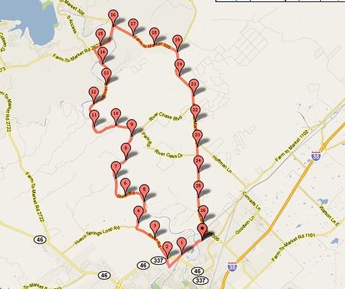
One thing to watch out for is River Road is very narrow. There are no shoulders on River Road, so you will have to ride in close proximity to cars, so prepare yourself. Last time I was there, I had to turn back due to repaving of the road. However I believe all that has been taken care of. This time of year, it is best to get up as early as possible to avoid weekend traffic. Once you hit FM 2763 and 306 there is a healthy shoulder, so you will be fine there. It's a great area to ride in and I think you'll have a great time. If you haven't been yet, you MUST go eat at The Gristmill restaurant before you leave.
Hope that helps, PM me if you have any more questions.
Here is a writeup I did on my last visit. https://www.bikeforums.net/showthread...and-San-Marcos
The best time to visit and ride is early spring / late fall when there is less traffic. I have found the residents of San Marcos and New Braunfels to be very patient and friendly with cyclists. However, this time of year there are lots of tourists there for camping and floating the river, they are not as tolerant nor are they as aware of what's going on around them. As far as the ride, the best bet is to park in municipal parking in Gruene right across from Gruene Hall. From there head West to the Loop then up to River Road. River Road itself is mostly flat, but there are some short steep climbs, especially early on. After that head east to FM 2763 and then onto FM 306. On the first part of FM 306 there is a very healthy climb followed by a descent back into New Braunfels and onto Gruene Road. That should be about 28 miles with around 1500 feet of climbing or so. That is the clockwise loop. Doing the loop counter clockwise takes out the steep hill on FM 306 and isn't as much fun IMHO. I've attached a map of the simple loop I described above. There is a longer route, going from 306 to Purgatory Road, down to San Marcos, and down Hunter Road back to Gruene. That route is about 52 miles.
One thing to watch out for is River Road is very narrow. There are no shoulders on River Road, so you will have to ride in close proximity to cars, so prepare yourself. Last time I was there, I had to turn back due to repaving of the road. However I believe all that has been taken care of. This time of year, it is best to get up as early as possible to avoid weekend traffic. Once you hit FM 2763 and 306 there is a healthy shoulder, so you will be fine there. It's a great area to ride in and I think you'll have a great time. If you haven't been yet, you MUST go eat at The Gristmill restaurant before you leave.
Hope that helps, PM me if you have any more questions.
Last edited by alpha_bravo; 07-29-10 at 01:07 PM.

