


Route planning application
 01-26-21, 08:35 PM
#1
Newbie
Thread Starter
Join Date: Nov 2015
Posts: 19
Mentioned: 0 Post(s)
Tagged: 0 Thread(s)
Quoted: 15 Post(s)
Liked 0 Times
in
0 Posts
Route planning application
Hello,
I like to map the entire route of a trip before I leave. I tried Openrunner and Komoot. The advantage of Komoot is that it follows itself the roads on the map. But after 200 or 300km (because my trips average around 500km in total), the detours and loops start to get all crooked on the map. I have just given up on entering the tour of Prince Edward Island (Canada) because it became impossible to follow the route suggested by the app. It was going crazy! I think that this app is not made for long trips of several days, but rather for trips of one day maximum.
Question: which app do you use to plan your trips of several days on maps??
Thank you.
Fran�ois Villeneuve
Rimouski, Qu�bec, Canada
 01-26-21, 09:17 PM
#2
Senior Member
Join Date: Aug 2010
Location: Madison, WI
Posts: 11,172
Bikes: 1961 Ideor, 1966 Perfekt 3 Speed AB Hub, 1994 Bridgestone MB-6, 2006 Airnimal Joey, 2009 Thorn Sherpa, 2013 Thorn Nomad MkII, 2015 VO Pass Hunter, 2017 Lynskey Backroad, 2017 Raleigh Gran Prix, 1980s Bianchi Mixte on a trainer. Others are now gone.
Mentioned: 47 Post(s)
Tagged: 0 Thread(s)
Quoted: 3450 Post(s)
Liked 1,449 Times
in
1,130 Posts
Before I go on a trip, I put a generalized route into a map on Mapsource on my home computer. Mapsource is an older Garmin program that is no longer supported by Garmin, but it still functions pretty well.
I usually use Komoot for distances that I would travel for a day or two just to see how that compares to what my Garmin GPS Model 64 suggests. In my Garmin I have a choice of method, I usually pick Tour Cycling and Minimize Elevation. Sometimes I check that against the route suggested for car routing on Maps.Me which is an Android app on my phone. And when all those routes look stupid, I look at the paper map and use that.
In other words, I use several options, and I do not rely on any single one for exclusive use. All of the electronic routing systems seem to favor state or provincial roads over local roads, but sometimes I see local roads on the paper map that make more sense and are more direct.
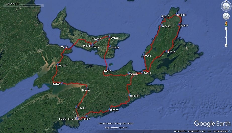
And, I often will change the route for local conditions. I rode PEI in June and July 2019, I did not plan to stop at Charlottetown, but the forecast had five consecutive days of rain, so I decided to check into the Hostel there for three nights to sit out the worst of the rain, thus all of my prior routing plans on PEI were discarded. I also often rode the trail system when it was convenient. For example, I rode on the Confederation Trail for almost the entire way from Charlottetown to the Confederation Bridge.
My route from Halifax to Halifax is on the attached map, the stops with numbers, those numbers represent the date of the first night I stayed at each location. To make that map I put my GPS data from my trip into Google Earth and took a screen shot of it.
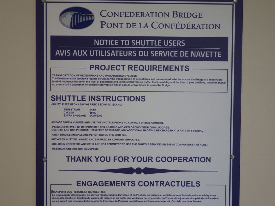
If you are not aware of this yet, they do not let you ride a bike across the Confederation Bridge. From PEI to New Brunswick was $9 CAD in 2019. I took the Ferry to PEI, the trip to PEI is free. Based on their price list, I suspected that they might want to charge me for each pannier, but they did not. The $9 cyclist fee was all they asked for.
They had a trailer to pull behind the shuttle van for bikes. I thought that they were doing a very good job to make sure my bike made the trip safely.

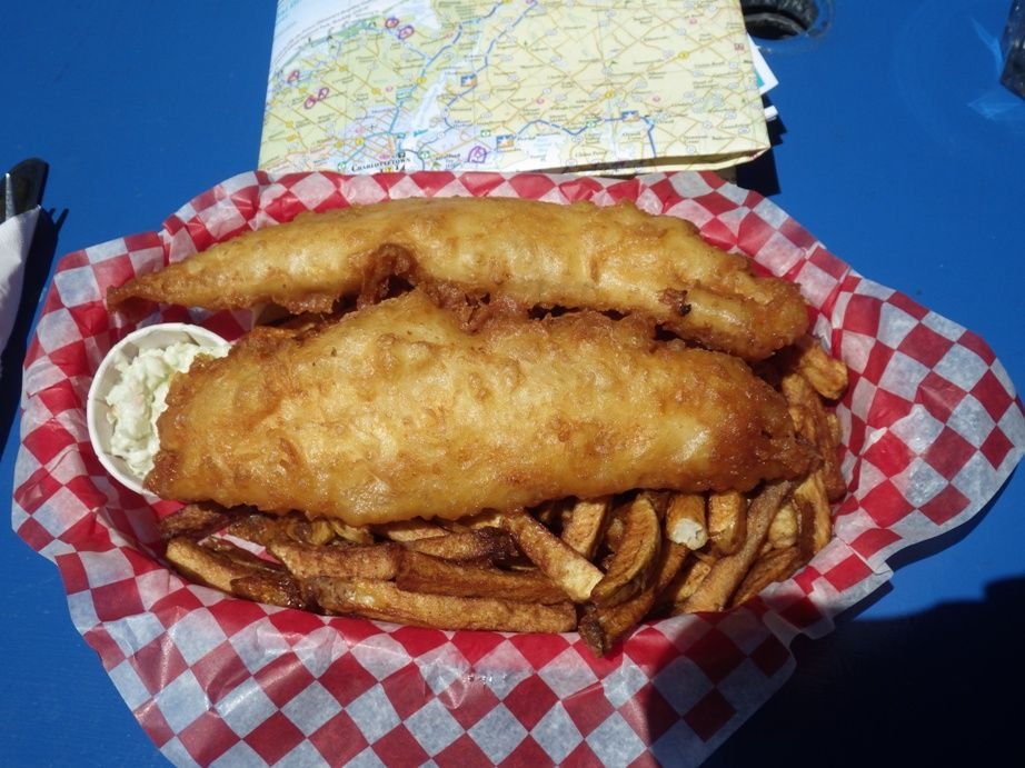
I recommend the fish and chips.
Have a great trip.
I usually use Komoot for distances that I would travel for a day or two just to see how that compares to what my Garmin GPS Model 64 suggests. In my Garmin I have a choice of method, I usually pick Tour Cycling and Minimize Elevation. Sometimes I check that against the route suggested for car routing on Maps.Me which is an Android app on my phone. And when all those routes look stupid, I look at the paper map and use that.
In other words, I use several options, and I do not rely on any single one for exclusive use. All of the electronic routing systems seem to favor state or provincial roads over local roads, but sometimes I see local roads on the paper map that make more sense and are more direct.
And, I often will change the route for local conditions. I rode PEI in June and July 2019, I did not plan to stop at Charlottetown, but the forecast had five consecutive days of rain, so I decided to check into the Hostel there for three nights to sit out the worst of the rain, thus all of my prior routing plans on PEI were discarded. I also often rode the trail system when it was convenient. For example, I rode on the Confederation Trail for almost the entire way from Charlottetown to the Confederation Bridge.
My route from Halifax to Halifax is on the attached map, the stops with numbers, those numbers represent the date of the first night I stayed at each location. To make that map I put my GPS data from my trip into Google Earth and took a screen shot of it.
If you are not aware of this yet, they do not let you ride a bike across the Confederation Bridge. From PEI to New Brunswick was $9 CAD in 2019. I took the Ferry to PEI, the trip to PEI is free. Based on their price list, I suspected that they might want to charge me for each pannier, but they did not. The $9 cyclist fee was all they asked for.
They had a trailer to pull behind the shuttle van for bikes. I thought that they were doing a very good job to make sure my bike made the trip safely.
I recommend the fish and chips.
Have a great trip.
01-26-21, 10:25 PM
#3
Senior Member
Join Date: Jan 2010
Posts: 39,201
Mentioned: 211 Post(s)
Tagged: 1 Thread(s)
Quoted: 18394 Post(s)
Liked 15,467 Times
in
7,308 Posts
I had never heard of Komoots until I saw a recent post in a regional forum. The route map included a segment on a long causeway across a bay in NJ that was demolished many years ago. Left me scratching my head as to why its data could be so inaccurate.
01-26-21, 11:14 PM
#4
Full Member
My wife does the routing using RidewithGPS. I load them on my garmin in the daily segments. Works for us.
01-26-21, 11:40 PM
#5
Senior Member
Join Date: Sep 2015
Location: QC Canada
Posts: 1,960
Bikes: Custom built LHT & Troll
Mentioned: 12 Post(s)
Tagged: 0 Thread(s)
Quoted: 837 Post(s)
Liked 149 Times
in
106 Posts
Once the route planning is done, compute and save waypoints on Locus Pro (Android) using bRouter as an add on. It is also possible to design a route on the computer and export/import waypoints to a phone.
Under way, navigate cities using my phone mounted on handlebars. When navigating on roads, I push routes from my phone to a fitness watch (F5) using Locus out.
This system works for months-long trips and hundreds of waypoints.
01-27-21, 04:31 PM
#6
Senior Member
Join Date: Sep 2007
Location: Far beyond the pale horizon.
Posts: 14,254
Mentioned: 31 Post(s)
Tagged: 0 Thread(s)
Quoted: 4242 Post(s)
Liked 1,342 Times
in
931 Posts
Ridewithgps should be able to do multiday trips.
It might make navigation easier or more reliable if you break a long trip up.
If you are planning overnights at specific places, they are natural places to break the track up.
It might make navigation easier or more reliable if you break a long trip up.
If you are planning overnights at specific places, they are natural places to break the track up.
Last edited by njkayaker; 01-27-21 at 04:36 PM.
01-28-21, 07:42 AM
#7
bicycle tourist
Now it is going to vary some by location and density of the road network. In large parts of western Canada or the US, there really aren't many road choices after that, so I'll roughly follow those routes. If I get local information e.g. road closures/construction then I may adjust further. The other spot that can get tricky is entry/exit into large cities. Here I'll do a combination of looking on "strava heat map" a previous evening to find routes taken by local cyclists and also sometimes having a cell phone give me bicycle directions to prescribed waypoints I've figured in advance.
01-28-21, 02:58 PM
#8
Senior Member
Join Date: Jul 2007
Location: South shore, L.I., NY
Posts: 6,856
Bikes: Flyxii FR322, Cannondale Topstone, Miyata City Liner, Specialized Chisel, Specialized Epic Evo
Mentioned: 18 Post(s)
Tagged: 0 Thread(s)
Quoted: 3220 Post(s)
Liked 2,043 Times
in
1,169 Posts
I’ve used RWGPS to create a track/route of the 1999 Bicycle Tour of Colorado. It had no issues with the 489 miles. If I were doing this as a navigable route I would break it down to daily segments as separate routes each day.
Likes For Steve B.:
01-28-21, 04:49 PM
#9
Senior Member
Join Date: Jan 2010
Posts: 39,201
Mentioned: 211 Post(s)
Tagged: 1 Thread(s)
Quoted: 18394 Post(s)
Liked 15,467 Times
in
7,308 Posts
I�ve mapped longer (by at least 200 miles) routes with no problem.
01-28-21, 05:09 PM
#10
bicycle tourist
I've done BTC twice and Ride the Rockies four times. Most of those routes are quite straightforward with not many turns (except for occasional things at start/end of the day to get exactly to your stopping point). So while they might be longer distance you might also be on the same road 10, 20, 40 miles before turning.
I also don't understand why the OP ran into issues - but how many turns and changes in direction are we talking about here?
As an aside, first mapping app I used was this one: https://artsandculture.google.com/as...8rVDIZSg?hl=en This was for a 1992 trip across the USA so an earlier version than the 1993 edition shown in the photo. I used it somewhat like I still use these mapping applications: (a) get the rough parameters for routes and things like overall distances (b) find tune on the way with maps and update as I go along.
Last edited by mev; 01-28-21 at 05:17 PM.
01-28-21, 08:14 PM
#11
Senior Member
Join Date: Jul 2007
Location: South shore, L.I., NY
Posts: 6,856
Bikes: Flyxii FR322, Cannondale Topstone, Miyata City Liner, Specialized Chisel, Specialized Epic Evo
Mentioned: 18 Post(s)
Tagged: 0 Thread(s)
Quoted: 3220 Post(s)
Liked 2,043 Times
in
1,169 Posts
My guess is distance isn't the right metric to use here. Rather, I suspect number of turns or other complexity makes more sense.
I've done BTC twice and Ride the Rockies four times. Most of those routes are quite straightforward with not many turns (except for occasional things at start/end of the day to get exactly to your stopping point). So while they might be longer distance you might also be on the same road 10, 20, 40 miles before turning.
I also don't understand why the OP ran into issues - but how many turns and changes in direction are we talking about here?
As an aside, first mapping app I used was this one: https://artsandculture.google.com/as...8rVDIZSg?hl=en This was for a 1992 trip across the USA so an earlier version than the 1993 edition shown in the photo. I used it somewhat like I still use these mapping applications: (a) get the rough parametersfor routes and things like overall distances (b) find tune on the way with maps and update as I go along.
01-28-21, 09:37 PM
#12
Senior Member
Join Date: Jan 2010
Posts: 39,201
Mentioned: 211 Post(s)
Tagged: 1 Thread(s)
Quoted: 18394 Post(s)
Liked 15,467 Times
in
7,308 Posts
RWGPS had no problem with my 500+ mile route from St. Albans, VT to Philly, which had plenty of turns.
01-28-21, 09:47 PM
#13
Full Member
I see that no-one has mentioned https://cycle.travel/
Not an app, but a website.
I've plotted routes of well over 1000 km on it.
Functionality for accommodation is optimal in Europe, but I found its routes superior (and safer!) to Komoot in the U.S. although it's address search function was weaker (or perhaps that was my lack of experience witn US addresses).
Instant access to Google Street view is very handy in tbe planning stages.
Definitely worth investigating.
01-31-21, 09:28 AM
#15
Senior Member
Join Date: Sep 2007
Location: Far beyond the pale horizon.
Posts: 14,254
Mentioned: 31 Post(s)
Tagged: 0 Thread(s)
Quoted: 4242 Post(s)
Liked 1,342 Times
in
931 Posts
Hello,
I like to map the entire route of a trip before I leave. I tried Openrunner and Komoot. The advantage of Komoot is that it follows itself the roads on the map. But after 200 or 300km (because my trips average around 500km in total), the detours and loops start to get all crooked on the map. I have just given up on entering the tour of Prince Edward Island (Canada) because it became impossible to follow the route suggested by the app. It was going crazy! I think that this app is not made for long trips of several days, but rather for trips of one day maximum.
Question: which app do you use to plan your trips of several days on maps??
Thank you.
Fran�ois Villeneuve
Rimouski, Qu�bec, Canada
I like to map the entire route of a trip before I leave. I tried Openrunner and Komoot. The advantage of Komoot is that it follows itself the roads on the map. But after 200 or 300km (because my trips average around 500km in total), the detours and loops start to get all crooked on the map. I have just given up on entering the tour of Prince Edward Island (Canada) because it became impossible to follow the route suggested by the app. It was going crazy! I think that this app is not made for long trips of several days, but rather for trips of one day maximum.
Question: which app do you use to plan your trips of several days on maps??
Thank you.
Fran�ois Villeneuve
Rimouski, Qu�bec, Canada
There shouldn't be any problem calculating routes of 500 km on a server.
02-10-21, 10:44 AM
#16
Sierra

Wiki makes available a handy Comparison of bicycle route planning websites. Note the devil is in the details to get any one app to perform (submit) to your needs.
Likes For ChrisWagner:


