


is my Garmin 1030+ gitchy?
 11-01-20, 07:18 PM
#1

Senior Member
Thread Starter
Join Date: Jan 2020
Posts: 2,346
Mentioned: 2 Post(s)
Tagged: 0 Thread(s)
Quoted: 680 Post(s)
Liked 947 Times
in
554 Posts
is my Garmin 1030+ gitchy?
I pretty much used google on my phone for GPS directions but I really wanted some visual as some directions are hard to follow. Plus I needed another gps so I got the 1030. I used ride gps to start making my maps but I started noticing that directions were coming after I passed the road I needed to turn on. I was thinking maybe it needed turned off as I have been putting it to sleep. so I turned it off and then chose return trip using the same route. but I would get opposite turn directions. I tested this and if I took the wrong turn I would get the warning wrong direction notification. I tired resetting it and starting fresh and tested it. it seemed fine on the trip out but when I chose return the same route I got two wrong promos one was a left turn instead of straight while on the bike path into a apartment complex. I also noticed voice prompts were not happening though thats not a big deal. But are the gamins pretty accurate on navigation?
 11-02-20, 01:44 AM
#2
Kamen Rider

Join Date: Aug 2017
Location: KL, MY
Posts: 1,071
Bikes: Fuji Transonic Elite, Marechal Soul Ultimate, Dahon Dash Altena
Mentioned: 11 Post(s)
Tagged: 0 Thread(s)
Quoted: 351 Post(s)
Liked 277 Times
in
164 Posts
It could be that the maps loaded for your particular region on the Garmin aren't as accurate.
I could also be the maps you used on RWGPS do not match or agree with Garmin's maps, and/or the actual roads. While planning your route on RWGPS, you'll notice their route planner gives you several map choices in the dropdown on the upper right corner. In some regions, you'll notice when you switch between them (e.g. between Map, RWGPS, and OSM Cycle), the roads don't line up (or plain don't exist on some maps).
I could also be the maps you used on RWGPS do not match or agree with Garmin's maps, and/or the actual roads. While planning your route on RWGPS, you'll notice their route planner gives you several map choices in the dropdown on the upper right corner. In some regions, you'll notice when you switch between them (e.g. between Map, RWGPS, and OSM Cycle), the roads don't line up (or plain don't exist on some maps).
11-02-20, 08:14 AM
#3
Senior Member
Thread Starter
Join Date: Jan 2020
Posts: 2,346
Mentioned: 2 Post(s)
Tagged: 0 Thread(s)
Quoted: 680 Post(s)
Liked 947 Times
in
554 Posts
I have found a few spots where bike paths would not work right drawing up the map. but toe one I really noticed was on a 5 miles stretch of a main road it water me to turn right sainted of keeping straight. it seems worse fo wrong directions when going back on the same course. most of my maps are pretty basic and I live in Portland Oregon so they are not odd location. I guess maybe draw one up in the connect app ad check it? but I think both apps use google for their maps.
Last edited by fooferdoggie; 11-02-20 at 08:17 AM.
11-02-20, 09:46 AM
#4
I'm good to go!
Join Date: Jul 2017
Location: Mississippi
Posts: 14,929
Bikes: Tarmac Disc Comp Di2 - 2020
Mentioned: 51 Post(s)
Tagged: 0 Thread(s)
Quoted: 6163 Post(s)
Liked 4,779 Times
in
3,297 Posts
If you are in a city with tall buildings, then gps's will suffer accuracy. 30ft is the best you should assume no matter what the accuracy resolution is showing in the device calculations for itself. No one but Garmin really know what that means. And the best guess is that it simply means that more than 50% of the calculations agreed that you where within that radius. But that doesn't mean that radius was the position you actually are.
Zoom in on your track, look at it on the satellite and mapping overlays and see if maybe you need to adjust how far out you get a turn cue. But if you are in an area of poor reception from buildings or terrain then good luck.
It always helps to just know where to go. Reliance on GPS might lower your cognitive awareness. I just use mine to record what I've done.
11-02-20, 10:30 AM
#5
Senior Member
Thread Starter
Join Date: Jan 2020
Posts: 2,346
Mentioned: 2 Post(s)
Tagged: 0 Thread(s)
Quoted: 680 Post(s)
Liked 947 Times
in
554 Posts
If you are in a city with tall buildings, then gps's will suffer accuracy. 30ft is the best you should assume no matter what the accuracy resolution is showing in the device calculations for itself. No one but Garmin really know what that means. And the best guess is that it simply means that more than 50% of the calculations agreed that you where within that radius. But that doesn't mean that radius was the position you actually are.
Zoom in on your track, look at it on the satellite and mapping overlays and see if maybe you need to adjust how far out you get a turn cue. But if you are in an area of poor reception from buildings or terrain then good luck.
It always helps to just know where to go. Reliance on GPS might lower your cognitive awareness. I just use mine to record what I've done.
Zoom in on your track, look at it on the satellite and mapping overlays and see if maybe you need to adjust how far out you get a turn cue. But if you are in an area of poor reception from buildings or terrain then good luck.
It always helps to just know where to go. Reliance on GPS might lower your cognitive awareness. I just use mine to record what I've done.
11-02-20, 10:47 AM
#6
Senior Member

Join Date: Nov 2017
Location: Seattle
Posts: 1,951
Bikes: Specialized Roubaix, Canyon Inflite AL SLX, Ibis Ripley AF, Priority Continuum Onyx, Santana Vision, Kent Dual-Drive Tandem
Mentioned: 20 Post(s)
Tagged: 0 Thread(s)
Quoted: 871 Post(s)
Liked 726 Times
in
436 Posts
My 520 would start giving me opposite turn directions at times too, usually after I missed a turn and had to make a u-turn somewhere. Also use RWGPS for routing, so it could be some weird interaction between the two.
11-06-20, 05:52 AM
#7
Senior Member
Join Date: Sep 2007
Location: Far beyond the pale horizon.
Posts: 14,254
Mentioned: 31 Post(s)
Tagged: 0 Thread(s)
Quoted: 4242 Post(s)
Liked 1,342 Times
in
931 Posts
The Garmins can be confused if you are at a place where the track also returns in the opposite direction. They can pick up the wrong leg especially when you are stopped. The Garmins lose heading when you are stopped. Usually, the sort themselves out but restarting the track in a place with one leg and moving in the right direction should get it to working properly again.
Every route planner produces the same sort of file. There no routing information in the files.
The files are just a list of coordinates that trace the turns and curves of the path you want to follow.
The Garmin Edges create a list of turns by walking the track and picking roads on the map installed on the device that the track appears to follow.
Ideally, one would use the same map to plan the route as is installed on the device. But, if it's fairly close, it still will generally still work.
The newer Garmins use Openstreetmap maps. One should try to use that when planning the route.
The Garmins can have issues with roads/paths that are right next to each other. And sometimes, they do shortcuts off the planned track.
Last edited by njkayaker; 11-06-20 at 06:14 AM.
11-06-20, 05:56 AM
#8
Senior Member
Join Date: Sep 2007
Location: Far beyond the pale horizon.
Posts: 14,254
Mentioned: 31 Post(s)
Tagged: 0 Thread(s)
Quoted: 4242 Post(s)
Liked 1,342 Times
in
931 Posts
Enable it from Navigation -> Courses -> Saved Courses -> (menu at lower right).
I have found a few spots where bike paths would not work right drawing up the map. but toe one I really noticed was on a 5 miles stretch of a main road it water me to turn right sainted of keeping straight. it seems worse fo wrong directions when going back on the same course. most of my maps are pretty basic and I live in Portland Oregon so they are not odd location. I guess maybe draw one up in the connect app ad check it? but I think both apps use google for their maps.
This is hard to understand.
Its possible that there is an error in one of the maps.
No one will be able to help you much without knowing exactly where this problem occurred.
=============================
Important.
The best way to use these devices for navigation is to also look at the map and see your location relative to the "purple" track line. This can't really ever be wrong (outside of a broken unit or being in "deep canyons"). It might sometimes be a little off but not by much.
This often lets you know of upcoming turns before they get announced and let you see that you are off course if you miss a turn. This also works when there isn't an announcement (where one might expect it).
It takes some practice/experience to include scanning the map while you are riding. (This is one reason to use navigation when you don't need to.)
If you are relying on the announcements, you'll have problems. I don't think relying on the announcements is using the devices well.
Last edited by njkayaker; 11-06-20 at 07:07 AM.
11-06-20, 06:41 AM
#9
Senior Member
Join Date: Sep 2007
Location: Far beyond the pale horizon.
Posts: 14,254
Mentioned: 31 Post(s)
Tagged: 0 Thread(s)
Quoted: 4242 Post(s)
Liked 1,342 Times
in
931 Posts
If you are in a city with tall buildings, then gps's will suffer accuracy. 30ft is the best you should assume no matter what the accuracy resolution is showing in the device calculations for itself. No one but Garmin really know what that means. And the best guess is that it simply means that more than 50% of the calculations agreed that you where within that radius. But that doesn't mean that radius was the position you actually are.
If you are relying on the announcements, you'll have problems. I don't think relying on the announcements is using the devices well.
How much do you know how the navigation works?
Last edited by njkayaker; 11-06-20 at 07:05 AM.
11-06-20, 08:45 AM
#10
I'm good to go!
Join Date: Jul 2017
Location: Mississippi
Posts: 14,929
Bikes: Tarmac Disc Comp Di2 - 2020
Mentioned: 51 Post(s)
Tagged: 0 Thread(s)
Quoted: 6163 Post(s)
Liked 4,779 Times
in
3,297 Posts
How navigation works on the device? Is that a pre-requisite? At what level of experience must we have to reply? I've used it enough to know that nothing beats just looking at a map before a trip and knowing where to go. It's not hard. Just takes a little practice.
I do know how navigation works though. I have always been pretty accurate with dead reckoning, pilotage or simply just instinct on land sea or air. I've always made it to my destination.
Your other comments to my reply are silly as most of your comments about them make specific assumptions about either the OP which at the time were unknown or you set up specific circumstance in your comment about my generalizations.
11-06-20, 08:58 AM
#11
Senior Member
Thread Starter
Join Date: Jan 2020
Posts: 2,346
Mentioned: 2 Post(s)
Tagged: 0 Thread(s)
Quoted: 680 Post(s)
Liked 947 Times
in
554 Posts
I admit I am terrible about navigation I have never driven a car and always used public transportation. hell I even had trouble with a mirror because I hardly ever use one. But I will check the GPS for the right settings. the one blatant wrong turn was on a 5 mile stretch on a city street and I got a turn arrow on the next street. I have gotten the same thing on a bike path to turn into a apartment complex. I have had wrong turns the nI choose return with the same course and it would give me opposite turn instructions.
11-06-20, 09:28 AM
#12
Senior Member
Join Date: Sep 2007
Location: Far beyond the pale horizon.
Posts: 14,254
Mentioned: 31 Post(s)
Tagged: 0 Thread(s)
Quoted: 4242 Post(s)
Liked 1,342 Times
in
931 Posts
Using a GPS doesn't have to be any different than "looking at a map".
You are overexaggerating the problems with gps reception.
Last edited by njkayaker; 11-06-20 at 09:32 AM.
11-06-20, 09:32 AM
#13
I'm good to go!
Join Date: Jul 2017
Location: Mississippi
Posts: 14,929
Bikes: Tarmac Disc Comp Di2 - 2020
Mentioned: 51 Post(s)
Tagged: 0 Thread(s)
Quoted: 6163 Post(s)
Liked 4,779 Times
in
3,297 Posts
11-06-20, 09:49 AM
#14
Senior Member
Join Date: Sep 2007
Location: Far beyond the pale horizon.
Posts: 14,254
Mentioned: 31 Post(s)
Tagged: 0 Thread(s)
Quoted: 4242 Post(s)
Liked 1,342 Times
in
931 Posts
I admit I am terrible about navigation I have never driven a car and always used public transportation. hell I even had trouble with a mirror because I hardly ever use one. But I will check the GPS for the right settings. the one blatant wrong turn was on a 5 mile stretch on a city street and I got a turn arrow on the next street. I have gotten the same thing on a bike path to turn into a apartment complex. I have had wrong turns the nI choose return with the same course and it would give me opposite turn instructions.
PM me with the link to the course and indicate where the problem was.
One can get tiny "bumps" in the route that cause fake turns. More care and experience with creating routes will reduce the frequency of that happening. But that will still happen and you'll have to learn to deal with it.
The track on the map screen should have shown it wasn't really a turn.
If you go just by the announcements, you will have these issues. The navigation works much better if you also look at the map.
It takes practice/experience to be able to include glances at the map with your other looking around. Which is why using the device when you don't need to is useful.
Ideally, you wouldn't take the announcements as commands but think a bit about whether they make sense.
The 1030+ shouldn't work much differently than the Explore. The 1030+ does have a compass, which means it knows your heading when stopped.
Having a sense of what the device is doing and how it works is useful.
The 1030+ and the 1030 aren't "glitchy" (I have direct experience with both). People spreading FUD about the units might discourage you from working through issues (and blame the device).
===================================
I suspect many people (not sure if that includes you) think that it's a matter of pressing a button and things "just work".
One has to put a little thought into using these and that, along with another thing to look at while riding, is not exactly easy at first.
Last edited by njkayaker; 11-06-20 at 10:17 AM.
11-06-20, 09:52 AM
#15
Senior Member
Join Date: Sep 2007
Location: Far beyond the pale horizon.
Posts: 14,254
Mentioned: 31 Post(s)
Tagged: 0 Thread(s)
Quoted: 4242 Post(s)
Liked 1,342 Times
in
931 Posts
It's not clear what the OP's issues are. It could be a few things (which I've tried to address).
His problem isn't reception in cities. So discussing that certainly doesn't answer the OP's issues!
Last edited by njkayaker; 11-06-20 at 10:03 AM.
11-06-20, 11:19 AM
#16
Senior Member
Thread Starter
Join Date: Jan 2020
Posts: 2,346
Mentioned: 2 Post(s)
Tagged: 0 Thread(s)
Quoted: 680 Post(s)
Liked 947 Times
in
554 Posts
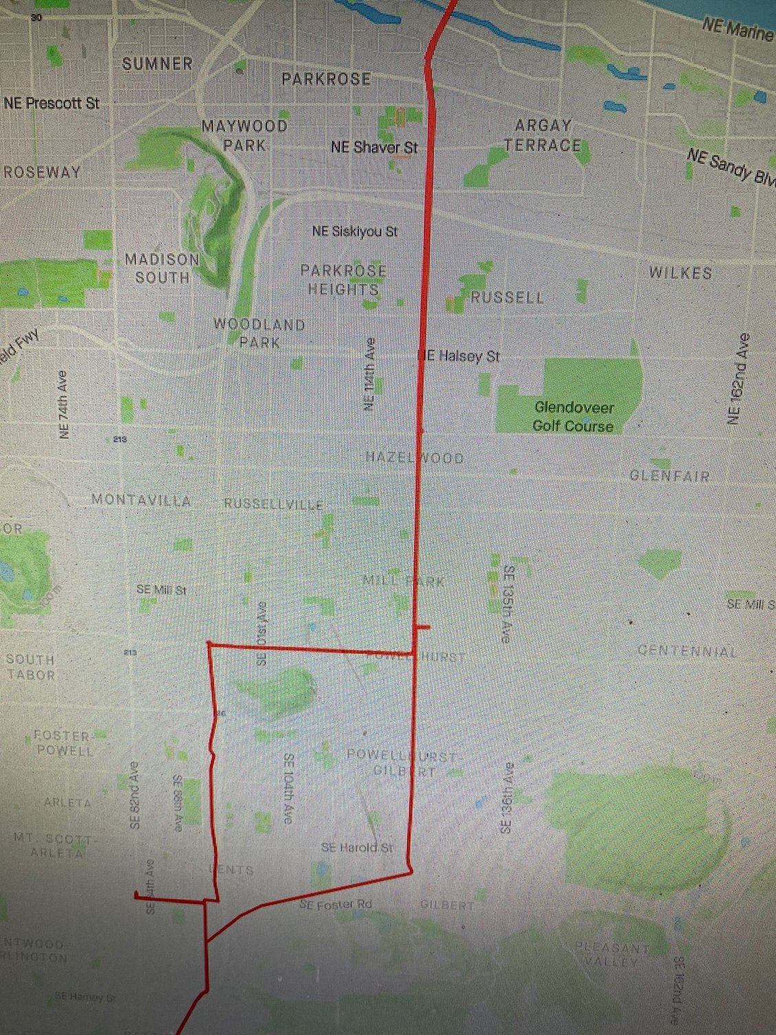
I Was planning on turning off the voice it gets annoying. Plus I have it so the direction is forward that would be easier for me. here is a snapshot of the map where I got the wrong turn one of them anyway. it is the little blip[ to the right I turned just to see what would happen. it was a 5 mile straight shot across town
11-06-20, 12:30 PM
#17
Senior Member
Join Date: Sep 2007
Location: Far beyond the pale horizon.
Posts: 14,254
Mentioned: 31 Post(s)
Tagged: 0 Thread(s)
Quoted: 4242 Post(s)
Liked 1,342 Times
in
931 Posts
Garmin calls that "track up". That's generally the best option to use.
So, you went off-course (by turning right?). I supposed you turned around?
Then, when you returned to the north/south street, you got a confusing turn indication?
If that's what happened, the issue is that there are two legs the Garmin can choose from. If you stopped at the intersection, it's even harder for it to pick the right one.
In this sort of case, you should continue the way you want and the device should be able to figure it out. It might stay a bit confused until you reach a point where there aren't two legs.
If you don't know the right way, that can be a problem. You can often tell that the device has picked the wrong leg by looking at the distance to end.
I use the following "data field" to display the current speed, average speed, distance traveled. and distance to end.
https://apps.garmin.com/en-US/apps/8...f-9f10113b5276
Things might work better if you disable "recalculation".
11-06-20, 12:37 PM
#18
Senior Member
Thread Starter
Join Date: Jan 2020
Posts: 2,346
Mentioned: 2 Post(s)
Tagged: 0 Thread(s)
Quoted: 680 Post(s)
Liked 947 Times
in
554 Posts
I'm assuming you mean you have it set so that the triangle showing your location always points to the top of the screen (so the arrow doesn't rotate).
Garmin calls that "track up". That's generally the best option to use.
I'm assuming you are talking about the small line pointing to the right (east) above Powell-Hurst?
So, you went off-course (by turning right?). I supposed you turned around?
Then, when you returned to the north/south street, you got a confusing turn indication?
If that's what happened, the issue is that there are two legs the Garmin can choose from. If you stopped at the intersection, it's even harder for it to pick the right one.
In this sort of case, you should continue the way you want and the device should be able to figure it out. It might stay a bit confused until you reach a point where there aren't two legs.
If you don't know the right way, that can be a problem. You can often tell that the device has picked the wrong leg by looking at the distance to end.
I use the following "data field" to display the current speed, average speed, distance traveled. and distance to end.
https://apps.garmin.com/en-US/apps/8...f-9f10113b5276
Things might work better if you disable "recalculation".
11-06-20, 12:42 PM
#19
Senior Member
Join Date: Sep 2007
Location: Far beyond the pale horizon.
Posts: 14,254
Mentioned: 31 Post(s)
Tagged: 0 Thread(s)
Quoted: 4242 Post(s)
Liked 1,342 Times
in
931 Posts
That could have been a minor issue with the course. When you are creating a course, don't click at intersections.
Looking at the map, it should have been obvious that it was wrong.

(I've seen that happen. It's not common though. Hopefully, there's a fix for that in the pipeline.)
Looking at the map, it should have been obvious that it was wrong.
(I've seen that happen. It's not common though. Hopefully, there's a fix for that in the pipeline.)
11-07-20, 10:11 AM
#20
Senior Member

Be like njkayaker - don't click on intersections!


