Still quite tentative:
.- Bus to Amtrak station in Chicago.
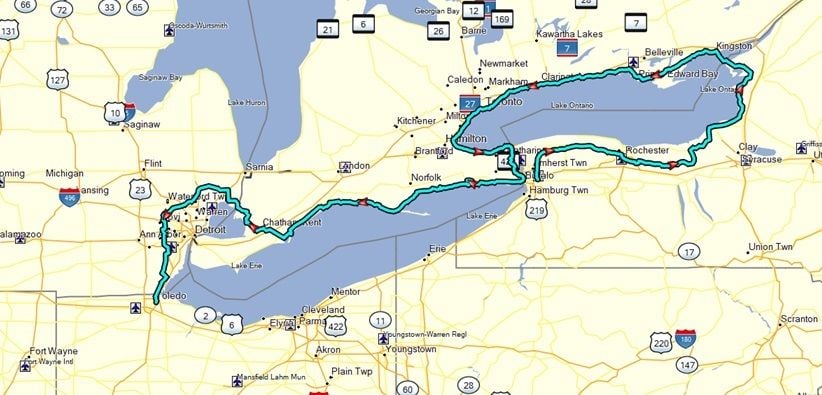
- Amtrak to Buffalo, NY.
- Bike East and North, initially on Empire State Trail, then on roads. Cross border to Kingston, Ontario.
- West on Waterfront to almost Windsor, but bypass Windsor because you can't cross border on a bike, head short distance North.
- Cross border into Algonac, MI.
- Bike around north and west sides of Detroit, mostly on trails, then head South to Toledo.
- Take Amtrak to Chicago.
- Bus home.
Roughly a thousand miles. Solo trip. Relaxed pace. Likely will get my Amtrak ticket home a few days in advance so the trip is completely open ended, I prefer to not have to make a schedule on a long tour. Could do it in four to five weeks, plus or minus. But much of it will be pretty flat, so maybe less time than I expect? I will travel at the speed I want to travel without schedule concerns.
Tentatively, leave home in early Jun so I can get most of the trip done before the campgrounds start to fill up. Not sure where I will be on Canada Day weekend, but I will worry about that when I am on the road. I learned on my last trip to Canada that I will need reservations for where I stay that weekend.
Plan to use my Lynskey Backroad touring bike. Likely with Ortlieb panniers. But I have some Carradry panniers, have to decide on which pannier set to bring.
I put together a tentative GPS track about a week ago. A mix of Google Map (with bike) routing, RWGPS routing, and picking out what appear to be little used roads in some cases. Both border crossings are by ferry, as some of the bridges that I would like to cross do not allow bikes. Have marked in the GPS file lots of campgrounds as waypoints, some from Google searching and some from the Open Maps system. I expect grocery stores to be plentiful, but I marked a few in my GPS in the more rural settings, I have some dietary issues and can't survive on convenience store fare. Put on my GPS track some motels near the end as campgrounds near Detroit and Toledo are not as frequent as I would like.
Downloaded several internet maps as PDFs that I can put on my phone later. The maps in Canada are VERY well detailed.
If I need to bailout early for some reason, can take a ferry across Lake Erie to Sandusky and bypass Detroit area, have that in my GPS plan as a contingency if I need to reduce distance near the end of trip. But that is only a contingency if something unplanned happens.
My phone will work in Canada for an extra $10 a month. Undecided on stove, liquid fuel or butane, but when my planning is down to that level of detail, that means I am in pretty good shape.
But the plans are still on my old computer, bought a new computer a week ago and still migrating data to the new computer. I have been using Mapsource for decades (vintage mapping software no longer supported by Garmin), but the Mapsource won't load onto my new Windows 11 machine, so I need to decide do I keep using old computer for my GPS stuff? Or do I change to new software. That is one temporary hiccup in the planning, but I have months to firm up my plan.