A couple other tidbits to add to the list of tools/resources that I listed earlier in the thread - although these are not related to the idea of balancing miles/elevation and how hard rides are:
- Strava heat map - see below
- Satellite imagery - Google Maps sat view, Ride With GPS sat layer, etc, etc
First up is the Strava heat map. If you are not familiar with it - this is an aggregation of various activity tracks from users of Strava. I do not know how often they aggregate data. It seems to me several years ago that there was a project where data up to a certain period of time was aggregated to generate what we see as the "heat map". That was a single-point aggregation, meaning the data going in to the heat map was not updated routinely.
Link:
https://www.strava.com/heatmap#7.00/....56123/hot/all
If someone has more information on what goes in to the heat map I would be curious to hear. I am sure if you dig on this forum or the internet, in general, there is discussion about it.
In any event, the Heat Map shows where there has been more cycling traffic (or kayaking, or hiking - depending on what filters you set to the map). What is good about this is for areas you have not cycled through they will show you where other riders have gone so you can get some idea of what more heavily traveled routes are, and what less traveled routes are.
If you think about it, the above actually does tie in to elevation some - generally speaking, bike travelers avoid elevation. However, you can't rely entirely on what the map is showing as locals that road ride, for example, may ride en mass on the roads paralleling bike trails showing that the bike trail is less traveled. It is, however, another good tool to assist in overall route planning - it does show where, hopefully, large numbers of cycling activity is, and is not. Whether the reason why there is cycling traffic in a particular route is high is what you are doing or not - that's another story. The local cycling club's 100m hill climb that has 400 riders a week competing on isn't necessarily where you want to take your 250lb combined weight touring load.
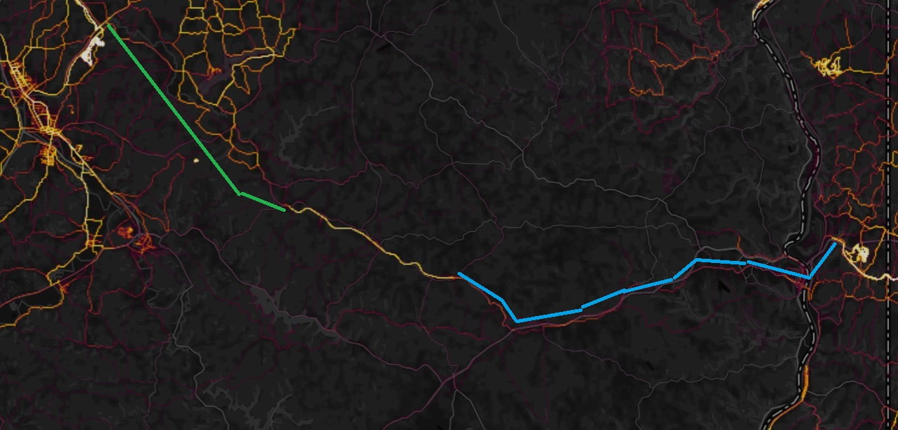
This example is from another route plan I am working on in eastern Ohio. On the left is the trail along the Tuscarawas River (South of Massilon). The green line is somewhat "no mans land" between that trail and the bright line you see in the middle - another trail - Conotton Creek Trail. On the right the blue line bridges the other trail through West Virginia to link up with the Panhandle trail. There are multiple ways to go on either "link" - if you look close you can see the more faint lines (pink/red) where people have been. The more yellow the routes are the more traveled they are.
As to the satellite views - I think the number 1 thing to look for on road routes is how wide the road is, which includes the shoulder. Lots of roads out in the boonies have no shoulder. Some roads have a nice wide shoulder. If there is any amount of traffic a wide shoulder is a blessing. For roads that are seldom traveled - small 2 lane, unmarked, chip-and-seal roads are fine to ride on - but the kicker is the traffic. In some areas of the country those same roads are actually the heavy traveled roads. In those areas you may have most roads gravel so chip-and-seal becomes a luxury race track. I've been on such roads and have had the unsettling sound of young people flooring import tuner cars about 1/4 mile behind me. That was before I had a mirror. After the first time that happened my reaction was to hit the ditch, which resulted in a few glorified dismounts in motion followed by a road-side yard sale, but better that than splat on what ever vehicle was quickly accelerating.