


Garmin Map question
 07-26-22, 05:13 PM
#26
Senior Member
Join Date: Sep 2007
Location: Far beyond the pale horizon.
Posts: 14,261
Mentioned: 31 Post(s)
Tagged: 0 Thread(s)
Quoted: 4246 Post(s)
Liked 1,351 Times
in
937 Posts
I had a long exchange with Garmin to do with delays on turn by turn directions on my Edge 830. Turned out the culprit was the map of Florida I had pulled from bbbike.org and loaded up. Once we removed that map the delay went away. Maybe the whole state of Florida was to much and I should have just done a county or two.
The Garmins calculate the route and all the turns at the start. So, there really shouldn't be any delays while using the route. Strange.
Lots of people use these maps and I've never heard of the problem you had.
If you had two maps enabled that covered the same region, that can cause problems.

Likes For njkayaker:
07-26-22, 05:42 PM
#27
Senior Member
Join Date: Mar 2010
Posts: 1,659
Mentioned: 7 Post(s)
Tagged: 0 Thread(s)
Quoted: 1248 Post(s)
Liked 1,323 Times
in
674 Posts
Or you can spend approx $20 and download the full Europe map from Garmin directly. Super simple and they work perfectly and are fully searchable.
Last edited by Atlas Shrugged; 07-26-22 at 05:52 PM.
07-26-22, 08:06 PM
#28
Senior Member
The old garmin.openstreetmap.nl that I used to use automatically redirects to garmin.bbbike.org. So I requested, received and extracted the zip file for Portugal.
I can see the gmapsupp file my Garmin device. But how can I get a map into BaseCamp?
I can see the gmapsupp file my Garmin device. But how can I get a map into BaseCamp?
07-27-22, 12:46 AM
#29
Obsessed with Eddington

Join Date: Jun 2013
Location: Brussels (BE) 🇧🇪
Posts: 1,330
Bikes: '16 Spesh Diverge, '14 Spesh Fatboy, '18 Spesh Epic, '18 Spesh SL6, '21 Spesh SL7, '21 Spesh Diverge...and maybe n+1?
Mentioned: 2 Post(s)
Tagged: 0 Thread(s)
Quoted: 532 Post(s)
Liked 621 Times
in
368 Posts
You will need to use a map installer to install a GMAP format map that BaseCamp can read. Garmin has a separate map installer program that you will need to do this. I am not sure if BBBike offers maps in this format, but with a little googling, it shouldn't be too hard to find them already built. I honestly have found much better success building routes in Komoot or Strava and then sending them to my Garmins over the years rather than using BaseCamp, primarily because those options offer better routing and there is the advantage of using heat maps (in Strava) to stick to roads that cyclists use.
07-27-22, 03:03 AM
#31
Senior Member
Join Date: Sep 2007
Location: Far beyond the pale horizon.
Posts: 14,261
Mentioned: 31 Post(s)
Tagged: 0 Thread(s)
Quoted: 4246 Post(s)
Liked 1,351 Times
in
937 Posts
You could use an actual USB or SD card too.
Make sure the virtual disk is indicated as “removable” (otherwise BaseCamp won’t see it).
Note you can rename the map file.
I use the following software.
https://www.ltr-data.se/opencode.html/#ImDisk
I create a shortcut to “mount” the drive.
Last edited by njkayaker; 07-27-22 at 03:27 AM.
07-27-22, 03:16 AM
#32
Senior Member
Join Date: Sep 2007
Location: Far beyond the pale horizon.
Posts: 14,261
Mentioned: 31 Post(s)
Tagged: 0 Thread(s)
Quoted: 4246 Post(s)
Liked 1,351 Times
in
937 Posts
I honestly have found much better success building routes in Komoot or Strava and then sending them to my Garmins over the years rather than using BaseCamp, primarily because those options offer better routing and there is the advantage of using heat maps (in Strava) to stick to roads that cyclists use.
Other planners are easier to use than BaseCamp.
BaseCamp, though, doesn�t need internet access.
BaseCamp is also fairly convenient as a route/track viewer. Especially, if you want to look at more than one track.
Likes For njkayaker:
07-27-22, 07:41 AM
#33
Newbie
Join Date: Jun 2022
Location: Florida
Posts: 55
Bikes: 1989 Dahon Stainless Steel Classic, 1993 Burley Samba Mixte tandem, 2002 Gary Fisher Hoo Koo E Koo, 2003 Co-Motion Speedster tandem, 2021 Trek Verve 3, 2021 Priority Current
Mentioned: 0 Post(s)
Tagged: 0 Thread(s)
Quoted: 13 Post(s)
Liked 31 Times
in
20 Posts
- Garmin DEM Map North America
- Garmin Geocode Map North America
- Trailforks
- AMR Standard Basemap, NR
- Garmin Cycle Map Amer, North
- Florida openfietslite/latin1 BBBike.org
Here is a picture of what it was doing. Blue arrow keeps moving, but after exiting traffic circle unit still thinks that's the next upcoming turn. Sometimes it would stay that way past a couple of turns then tell you to make a U turn to go back to the parts you "missed" even if you were still on course. Removing the openfietslite map resolved this behavior. Yeah, they said they'd not seen this either, don't know why my unit is special, but hopefully the next person that runs up against this might find this and save a little time.

Already exited the traffic circle, but unit thinks we haven't gotten there yet.
07-27-22, 07:55 AM
#34
Senior Member
Join Date: Mar 2010
Posts: 1,659
Mentioned: 7 Post(s)
Tagged: 0 Thread(s)
Quoted: 1248 Post(s)
Liked 1,323 Times
in
674 Posts
My understanding is any updates are covered for the 1st year. I have gone down the freebie map route and yes they work however the Garmin maps just work better, are clearer and include popularity routing. It�s only $20 and for a lot of us it�s worth it. Just look at this thread and read all the goofy challenges people are encountering.
07-27-22, 08:04 AM
#35
Senior Member
Join Date: Sep 2007
Location: Far beyond the pale horizon.
Posts: 14,261
Mentioned: 31 Post(s)
Tagged: 0 Thread(s)
Quoted: 4246 Post(s)
Liked 1,351 Times
in
937 Posts
My understanding is any updates are covered for the 1st year. I have gone down the freebie map route and yes they work however the Garmin maps just work better, are clearer and include popularity routing. It’s only $20 and for a lot of us it’s worth it. Just look at this thread and read all the goofy challenges people are encountering.
A year is close to nothing. It’s also not hard to use the other options.
Some of the Garmins don't have enough space for two large maps. So, people would need to remove the standard map, install a very large map, removing it when they return and, reinstall the very large standard map. Using a custom map (which is typically much, much smaller) avoids this "challenge".
It’s also $20 for each Garmin on the trip.
(I think the Garmin versions generally look fine but some people don't like it.)
====================================
Note that the newer Garmins (1030+, 1040, maybe the Explore2) come with world-wide maps.
Last edited by njkayaker; 07-27-22 at 09:54 AM.
07-27-22, 08:20 AM
#36
Senior Member
Join Date: Sep 2007
Location: Far beyond the pale horizon.
Posts: 14,261
Mentioned: 31 Post(s)
Tagged: 0 Thread(s)
Quoted: 4246 Post(s)
Liked 1,351 Times
in
937 Posts
(Customer support is expensive for companies. Often, the support groups are given directions to reduce the cost. One easy way of doing that is not dealing with issues that are anyway related to non-company products. The staff is often trained to deal with a limited range of issues too.)
(One of Garmin's own maps doesn't work in Garmin's BaseCamp product. Garmin has no idea why. The other maps (out of like 5) work fine in BaseCamp.)
I had these maps installed:
Already exited the traffic circle, but unit thinks we haven't gotten there yet.
- Garmin DEM Map North America <elevation data.>
- Garmin Geocode Map North America <points of interests for address lookup.>
- Trailforks <maps for mountain biking used for Trailforks feature.>
- AMR Standard Basemap, NR <world-wide base map. doesn't have much detail. "NR" means no rouiting information.>
- Garmin Cycle Map Amer, North <map for North America (which included Florida). This has routing information.>
- Florida openfietslite/latin1 BBBike.org <Much the same as the "Garmin Cycle Map" but just covering Florida.>
Already exited the traffic circle, but unit thinks we haven't gotten there yet.
You have to disable one of these maps. "Removing" either map would have resolved the issue!
It's a known problem (known for years), It would happen with two Garmin maps that covered the same region.
======================
Why did you install a Florida map (when the Garmin map already covered it)?
Last edited by njkayaker; 07-27-22 at 08:46 AM.
07-27-22, 09:02 AM
#37
Newbie
Join Date: Jun 2022
Location: Florida
Posts: 55
Bikes: 1989 Dahon Stainless Steel Classic, 1993 Burley Samba Mixte tandem, 2002 Gary Fisher Hoo Koo E Koo, 2003 Co-Motion Speedster tandem, 2021 Trek Verve 3, 2021 Priority Current
Mentioned: 0 Post(s)
Tagged: 0 Thread(s)
Quoted: 13 Post(s)
Liked 31 Times
in
20 Posts
Mostly to try new things and learn, and I have! Thank you for that excellent description of the different maps. Secondarily was to see if I can get more accurate heatmap based routing of where people actually go. The Garmin data has tried to send me down roads that aren't roads, across fences into private property, and doesn't seem to know about a rail trail extension here so it keeps yelling U-Turn! U-Turn! until we clear that section and get back to something it knows.
07-27-22, 09:11 AM
#38
Senior Member
Join Date: Sep 2007
Location: Far beyond the pale horizon.
Posts: 14,261
Mentioned: 31 Post(s)
Tagged: 0 Thread(s)
Quoted: 4246 Post(s)
Liked 1,351 Times
in
937 Posts

------------------------------------------------
* Garmin uses its own data for points-of-interest (POI). Part of this is for "advertising revenue" and part of it is that OSM can be spotty with respect to POIs.
07-27-22, 10:01 AM
#39
Newbie
Join Date: Jun 2022
Location: Florida
Posts: 55
Bikes: 1989 Dahon Stainless Steel Classic, 1993 Burley Samba Mixte tandem, 2002 Gary Fisher Hoo Koo E Koo, 2003 Co-Motion Speedster tandem, 2021 Trek Verve 3, 2021 Priority Current
Mentioned: 0 Post(s)
Tagged: 0 Thread(s)
Quoted: 13 Post(s)
Liked 31 Times
in
20 Posts
Garmin wants us to hop a fence and ride the drainage canal.
I sent in a report to Garmin with coordinates and gpx file a few months ago for the rail trail thing, guess the correct answer to that is "just wait longer!"
07-27-22, 10:46 AM
#40
Senior Member
Join Date: Sep 2007
Location: Far beyond the pale horizon.
Posts: 14,261
Mentioned: 31 Post(s)
Tagged: 0 Thread(s)
Quoted: 4246 Post(s)
Liked 1,351 Times
in
937 Posts
Garmin won't fix it. It's not really Garmin's responsibility.
Understanding why is kind of important for using these devices for navigation effectively.
I removed the "path" and added the fence.
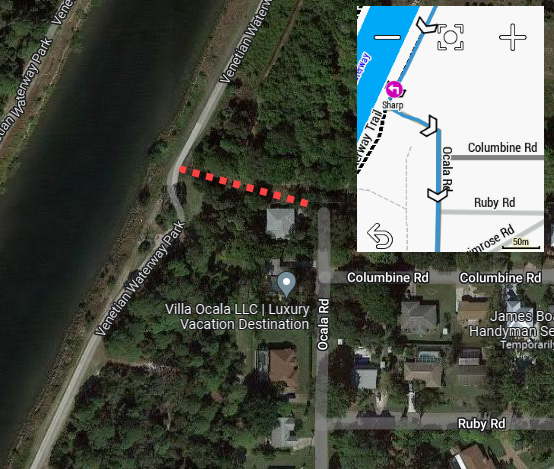
Here's a recent example. The inset is what the Edge thought we should do - take a sharp left off the waterway trail on "Unnamed Road" (or something like that) then a right on to Ocala Rd. Turns out that Unnamed Road shown with red dots on the Google Earth picture is really a drainage ditch with a fence all the way across it.
Garmin wants us to hop a fence and ride the drainage canal.
I sent in a report to Garmin with coordinates and gpx file a few months ago for the rail trail thing, guess the correct answer to that is "just wait longer!"
Garmin wants us to hop a fence and ride the drainage canal.
I sent in a report to Garmin with coordinates and gpx file a few months ago for the rail trail thing, guess the correct answer to that is "just wait longer!"
-------------------------------------------
Keep in mind that the routing favors the shortest distance.
The maps that come with the current Garmin units are Openstreetmap (OSM) maps. Openstreetmap is a publicly-maintained map database. One reason Garmin uses OSM maps is because they are cheap (free) and Garmin doesn't have to deal with the expense of maintaining them. Another reason to use OSM is that the OSM maps contain cycling-specific features that commercial maps don't have. Google has some of these but other companies can't really use Google's maps (outside of a limited way).
As far as the OSM data is, that route looks OK (as far as the world the map knows about, there is no fence or ditch).
The problem is that the map doesn't match the reality as accurately as it should. This a fundamental problem with maps: maps can't match reality exactly.
No one would be able to determine the quality of that "cheat route" unless they went and physically surveyed it. No commercial company is going to do that (it's way too expensive). People who live in the area and update OSM might.
The commercial maps ("City navigator") that Garmin sells wouldn't have the bike path (or the ditch or the fence).
The "track" (the path) is shown on OSM but not on Google maps. That Google maps doesn't have it might not be a good thing either: people might have legitimate reasons to want to get to a road at that location.
-------------------------------------------
Openstreetmap
https://www.openstreetmap.org/#map=1...5986/-82.43200
Last edited by njkayaker; 07-27-22 at 05:27 PM.
Likes For njkayaker:
07-27-22, 11:02 AM
#41
Senior Member
Join Date: Sep 2007
Location: Far beyond the pale horizon.
Posts: 14,261
Mentioned: 31 Post(s)
Tagged: 0 Thread(s)
Quoted: 4246 Post(s)
Liked 1,351 Times
in
937 Posts
Here's an interesting example of the issue.
If you click on the Google map, there's no direct way to get from Orchard Street (at the north) to Twinbrook (at the south):
If you click on the Google map, there's no direct way to get from Orchard Street (at the north) to Twinbrook (at the south):
Google Streetview shows a completely fine path to use:
https://www.google.com/maps/@41.0487...=en&authuser=0
OSM has the path. As a result, the routing (for cyclists) at this spot will be better than Google maps.
https://www.openstreetmap.org/#map=1...4820/-74.14594
Last edited by njkayaker; 07-27-22 at 12:03 PM.
07-27-22, 12:00 PM
#42
Senior Member
One way to get them into BaseCamp is to create a virtual USB disk and put the img file into a \Garmin folder on the disk.
You could use an actual USB or SD card too.
Make sure the virtual disk is indicated as �removable� (otherwise BaseCamp won�t see it).
Note you can rename the map file.
I use the following software.
Tools and utilities for Windows
I create a shortcut to �mount� the drive.
You could use an actual USB or SD card too.
Make sure the virtual disk is indicated as �removable� (otherwise BaseCamp won�t see it).
Note you can rename the map file.
I use the following software.
Tools and utilities for Windows
I create a shortcut to �mount� the drive.
https://www.openmapchest.org
07-27-22, 12:21 PM
#43
Senior Member
My understanding is any updates are covered for the 1st year. I have gone down the freebie map route and yes they work however the Garmin maps just work better, are clearer and include popularity routing. It�s only $20 and for a lot of us it�s worth it. Just look at this thread and read all the goofy challenges people are encountering.
07-27-22, 12:23 PM
#44
Senior Member
Join Date: Mar 2010
Posts: 1,659
Mentioned: 7 Post(s)
Tagged: 0 Thread(s)
Quoted: 1248 Post(s)
Liked 1,323 Times
in
674 Posts
07-27-22, 02:34 PM
#45
Senior Member
Join Date: Sep 2007
Location: Far beyond the pale horizon.
Posts: 14,261
Mentioned: 31 Post(s)
Tagged: 0 Thread(s)
Quoted: 4246 Post(s)
Liked 1,351 Times
in
937 Posts
https://www.garmin.com/en-US/c/outdoor-maps/cycling-maps/
Downloaded Garmin Cycle Maps cost $20. They are $50 on a microSD card.
The source for OSM data is free. So the OSM maps are cheaper than the City Navigator maps (which are more tailored for cars, anyway).
Last edited by njkayaker; 07-27-22 at 02:39 PM.
Likes For njkayaker:
