


which planning system do you trust?
 05-02-22, 05:14 AM
#51
Senior Member
Hey Toronto guy, you know your capabilities, but how much load weight will your friend be carrying and any idea what gearing the person's bike has, in gear inches?
I guess other than doing repeats into the Don Valley , you guys don't have a ton of climbing training rides do you?
I guess other than doing repeats into the Don Valley , you guys don't have a ton of climbing training rides do you?
 05-02-22, 12:05 PM
#52
Senior Member
Thread Starter
Join Date: May 2008
Location: Toronto, Canada
Posts: 890
Bikes: (shortlist) Cyclops, Marinoni, Mariposa, Air Firday, Pocket Rocket Pro, NWT, SLX Fuso, Claude Pottie (France) x3, Masi Team 3v, Lemond Zurich, Bianchi OS
Mentioned: 2 Post(s)
Tagged: 0 Thread(s)
Quoted: 160 Post(s)
Liked 33 Times
in
26 Posts
Hey Toronto guy, you know your capabilities, but how much load weight will your friend be carrying and any idea what gearing the person's bike has, in gear inches?
I guess other than doing repeats into the Don Valley , you guys don't have a ton of climbing training rides do you?
I guess other than doing repeats into the Don Valley , you guys don't have a ton of climbing training rides do you?
When I signed up for a Tour de Mont Blanc trip a few years ago (gulp, 10? time flies) I did indeed "train" on the Bayview Extension hill which runs alongside the Don Valley Parkway, Google Maps says it is 2.3km one way and 62m vertical, so doing 20 reps of this was at least something.
there are a few other "hills" - Rattlesnake Point, up the Niagara Escarpment.... but you really have to seek them out.
 05-02-22, 12:14 PM
#53
Senior Member
Thread Starter
Join Date: May 2008
Location: Toronto, Canada
Posts: 890
Bikes: (shortlist) Cyclops, Marinoni, Mariposa, Air Firday, Pocket Rocket Pro, NWT, SLX Fuso, Claude Pottie (France) x3, Masi Team 3v, Lemond Zurich, Bianchi OS
Mentioned: 2 Post(s)
Tagged: 0 Thread(s)
Quoted: 160 Post(s)
Liked 33 Times
in
26 Posts
I like the mediative quality of loaded or semi-loaded touring. Just plodding along, on the steepest bits (and there were a few in the Azores) dropping to 6-8kph, just fast enough to not topple over, and muttering Left, Right, Left, Right.... under my breath. until I got to the top.
But This trip will be credit card touring, with our gear likely shuttled from hotel to hotel. I'm 64. life is short enough.
05-02-22, 12:19 PM
#54
Senior Member
Thread Starter
Join Date: May 2008
Location: Toronto, Canada
Posts: 890
Bikes: (shortlist) Cyclops, Marinoni, Mariposa, Air Firday, Pocket Rocket Pro, NWT, SLX Fuso, Claude Pottie (France) x3, Masi Team 3v, Lemond Zurich, Bianchi OS
Mentioned: 2 Post(s)
Tagged: 0 Thread(s)
Quoted: 160 Post(s)
Liked 33 Times
in
26 Posts
it is more the overall elevation estimating I want to get a handle on. THAT is harder to gauge from a map over a long route.
and while this trip is just for personal pleasure/challenge, that's a good idea seeing whwat routes and lengths of days other tour companies suggest.
(Though My commercial trips are all just day loop rides from a base camp. I don't offer Point to Point to Point trips.)
and depending on the fitness of clientele other tour companies are targetting, I figure I can take a competitors trip and add 20-50% more distance.
though I think Thompson Tours targets a pretty strong rider base and so I would probably aim from no more than their daily distances.
I presume you consider Komoot fairly accurate? Given the +/-20% evelation stats of the 3 planners I have tried, that's really what I am trying to nail down ,
checking my test Corsica Day 1 (north on the east coast up from Bastia, then down the west coast of the penninsula to Saint Florent) Komoot is esitimating 1700m vertical which is 618m (+60%) More than Google Maps, 163m (-10%) less than RWGPS, 247m (-13%) less than BRouter and 724m (-30%) less than RouteYou.
so I think I'll throw out the high and low outliers (Google Maps, and Route You) and stick with Komoot or RWGPS and maybe BRouter which all seem close enough.
cheers
Peter
Last edited by pstock; 05-02-22 at 12:55 PM.
05-02-22, 01:11 PM
#55
Senior Member
True, around here (and in most of southern and middle ontario) you have to really seek out "hills" if you want to get your GPM legs in shape. (i.e. there aint many hills)
When I signed up for a Tour de Mont Blanc trip a few years ago (gulp, 10? time flies) I did indeed "train" on the Bayview Extension hill which runs alongside the Don Valley Parkway, Google Maps says it is 2.3km one way and 62m vertical, so doing 20 reps of this was at least something.
there are a few other "hills" - Rattlesnake Point, up the Niagara Escarpment.... but you really have to seek them out.
And your screenshot made me remember going to the leaside hockey arena all the time, my best friend played hockey there.
Remember the mohovlich brothers in the NHL in the 60s? Their dad was the ice sharpener guy at the leaside arena, his little cubicle jammed pack with his sons NHL photos, very impressive to us kids.
Small world eh?
05-02-22, 07:30 PM
#56
Senior Member
Join Date: Aug 2010
Location: Madison, WI
Posts: 11,199
Bikes: 1961 Ideor, 1966 Perfekt 3 Speed AB Hub, 1994 Bridgestone MB-6, 2006 Airnimal Joey, 2009 Thorn Sherpa, 2013 Thorn Nomad MkII, 2015 VO Pass Hunter, 2017 Lynskey Backroad, 2017 Raleigh Gran Prix, 1980s Bianchi Mixte on a trainer. Others are now gone.
Mentioned: 48 Post(s)
Tagged: 0 Thread(s)
Quoted: 3459 Post(s)
Liked 1,465 Times
in
1,143 Posts
I do not look at elevation totals at all.
If possible, I look at elevation profiles so I can see what the bigger hills look like. And even the small ones can be worse if steep, if possible I like to see what the percent grades are.
..
.... I might look at height of individual hills, but I do not look for totals.
If possible, I look at elevation profiles so I can see what the bigger hills look like. And even the small ones can be worse if steep, if possible I like to see what the percent grades are.
..
.... I might look at height of individual hills, but I do not look for totals.
05-03-22, 01:24 PM
#57
Senior Member
The first Bikecentennial groups had a leader. Bikecentennial, now Adventure Cycling Association, also had detailed route maps for the first routes across.the US. They were useful, but if you wanted to go on your own you had to use maps that covered a larger area.
05-30-22, 07:25 PM
#58
Junior Member
Join Date: Sep 2018
Posts: 78
Mentioned: 0 Post(s)
Tagged: 0 Thread(s)
Quoted: 24 Post(s)
Likes: 0
Liked 23 Times
in
18 Posts
In my area Google Maps can be dangerously misleading to the traveler. It'll route you on difficult single track trails in the foothills. Once I force it to follow known roads, it's usually not too bad. But once I found an anomaly at crossing of the Platte River where elevation data went to zero, over 5000' down. That was the easier mile I ever climbed.
Sorry, I have no experience with other apps. I'm one of those old guys who managed to make across the country in the 70s and that's still good enough.
Sorry, I have no experience with other apps. I'm one of those old guys who managed to make across the country in the 70s and that's still good enough.
05-31-22, 05:18 AM
#59
Senior Member
I miss the days when I would be eastbound and run into westbound riders and we would spread a map out on the campsite picnic table. And I might say, "There's a little back road from Bakersville to Patumka, but it's not on the map." Yes, the online apps may show the back road, but you don't get the same interchange. And yes, I know that back in the "good ole days" if you asked Bubba at the hardware store about how tough Highway 57 was heading to Jubilee City, he would tell you, "Ah, it's pretty flat." And then it would be nonstop rollers. And yet, there is something lost in the small screen - small on a laptop - miniscule on a phone. I used to get a USA road map from AAA after I finished a cross-country trip and use a highlighter to mark my entire ride. Trust me, it is more informative and more emphatic than an 800 x 600 pixel map online.
I plan to ride the TA again in 2026. I'd love to think I'll be able to do exactly what you describe again like I did when I rode it in 2007. It makes me a little sad to think that may not be possible. Don't get me wrong. I'll be thankful to be able to do the ride even if there i are no paper maps available. If that were the case, I'd have to decide whether the sentiment softie in me would carry my out of date 2007 maps or the weight weenie would prevail knowing they will be far out of date.
State maps were free at many gas stations in those days, also at state visitor centers. I know that in 2007, we generally did pick one up for most states, but I don't think we ever really considered it enough of a necessity that we worried about it if we didn't run across a free one. We usually gave them away to the first rider going the other way when we were at or close to the next state line. We got some of our state maps from riders going the other way doing the same.
05-31-22, 07:33 AM
#60
Senior Member

I would say RidewithGPS is the more accurate than Google Maps.
In RidewithGPS you can select OpenStreetMap (OSM) Cycle, which has an overlay for cycling routes etc., which is very accurate in terms of routing at least. For Europe they contain all the EV (Eurovelo) long distance routes accross the continent for instance, as well as national cycling routes for several countries. Not sure where RideWithGPS pulls the elevation data from, but I doubt it is the same as Google maps.
I would trust these maps over Google Maps, as they seem more accurate on routing in general, and cycleable routes specifically (designated cycle routes, paved/unpaved, etc.). The paved vs. unpaved info I have also found to be mostly accurate on a recent trip in Southern France.
Google maps is really made for cars, and the info on cycling and walking is very poor. Its suggestions on cycling routes are mediocre at best, and in some cases outright dangerously inaccurate.
Last edited by maartendc; 05-31-22 at 07:36 AM.
06-01-22, 12:38 PM
#61
Senior Member
Join Date: Sep 2007
Location: Far beyond the pale horizon.
Posts: 14,261
Mentioned: 31 Post(s)
Tagged: 0 Thread(s)
Quoted: 4246 Post(s)
Liked 1,351 Times
in
937 Posts
For world-wide elevation data, there are very few sources. So, it�s fairly likely Google and RWGPS are using the same data.
https://gisgeography.com/free-global-dem-data-sources/
06-01-22, 06:57 PM
#62
Senior Member
Thread Starter
Join Date: May 2008
Location: Toronto, Canada
Posts: 890
Bikes: (shortlist) Cyclops, Marinoni, Mariposa, Air Firday, Pocket Rocket Pro, NWT, SLX Fuso, Claude Pottie (France) x3, Masi Team 3v, Lemond Zurich, Bianchi OS
Mentioned: 2 Post(s)
Tagged: 0 Thread(s)
Quoted: 160 Post(s)
Liked 33 Times
in
26 Posts
reply from RouteYou
here's a reply I got from RouteYou when I asked them why their Elevation estimates were so high.
Thanks Peter
I think you are correct to say that the RouteYou D+ of 2687m are on the high side. Google will indeed be on the low side. The truth will be somewhere in the middle.
I am not really familiar with the coast roads of Corsica, but I guess it will be an issue of 'noise in our elevation model'. Maybe a technical story, but an elevation model is build up out of cells with a certain resolution. We know the height in these cells, but due to the size of the cells in our elevation model (90m x 90m) you can have a lot of noise in the resulting heights along a route if there is a lot of (extreme) height variation on a small distance. For example, a route along a road lying on a cliff. Sometimes the cell used to link a height to a point in the route will have the height of a lower lying area and sometimes the height of a higher lying area. A bit similar to below image along a river in a rough landscape:
You can also see that noise in the elevation profile:
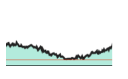
We do our best to filter out that noise, but sometimes it still results in an exaggeration. Could you send me the link to the route on RouteYou. I can look into this problem and see if I can tweak our algorithm a bit to give a beter indication.
Regards,
Thanks Peter
I think you are correct to say that the RouteYou D+ of 2687m are on the high side. Google will indeed be on the low side. The truth will be somewhere in the middle.
I am not really familiar with the coast roads of Corsica, but I guess it will be an issue of 'noise in our elevation model'. Maybe a technical story, but an elevation model is build up out of cells with a certain resolution. We know the height in these cells, but due to the size of the cells in our elevation model (90m x 90m) you can have a lot of noise in the resulting heights along a route if there is a lot of (extreme) height variation on a small distance. For example, a route along a road lying on a cliff. Sometimes the cell used to link a height to a point in the route will have the height of a lower lying area and sometimes the height of a higher lying area. A bit similar to below image along a river in a rough landscape:
You can also see that noise in the elevation profile:
We do our best to filter out that noise, but sometimes it still results in an exaggeration. Could you send me the link to the route on RouteYou. I can look into this problem and see if I can tweak our algorithm a bit to give a beter indication.
Regards,
Last edited by pstock; 06-01-22 at 07:01 PM.
Likes For pstock:

 06-01-22, 09:20 PM
#64
Partially Sane.
Join Date: Jan 2016
Location: Sunny Sacramento.
Posts: 3,559
Bikes: Soma Saga, pre-disc
Mentioned: 22 Post(s)
Tagged: 0 Thread(s)
Quoted: 972 Post(s)
Likes: 0
Liked 643 Times
in
468 Posts
Thank you, that's what I usually do too.
Or sometimes I ask for advice here, but only if it's too late, and I'm already on the road. 🙄😁
Last year, I decided to go a different way, up to Seattle, from Sacramento. I went across to Lake Tahoe, then North through Reno & those other little towns in Nevada. The only issue was in the far Northern end of Nevada, when I had to ride an extra 20 miles each way, to get enough food & water to make it. 😲🙄 Those deserts go right up into Oregon, believe it or not, so you need a lot of water. 😁
06-02-22, 04:20 AM
#65
Senior Member
here's a reply I got from RouteYou when I asked them why their Elevation estimates were so high.
Thanks Peter
I think you are correct to say that the RouteYou D+ of 2687m are on the high side. Google will indeed be on the low side. The truth will be somewhere in the middle.
I am not really familiar with the coast roads of Corsica, but I guess it will be an issue of 'noise in our elevation model'. Maybe a technical story, but an elevation model is build up out of cells with a certain resolution. We know the height in these cells, but due to the size of the cells in our elevation model (90m x 90m) you can have a lot of noise in the resulting heights along a route if there is a lot of (extreme) height variation on a small distance. For example, a route along a road lying on a cliff. Sometimes the cell used to link a height to a point in the route will have the height of a lower lying area and sometimes the height of a higher lying area. A bit similar to below image along a river in a rough landscape:
You can also see that noise in the elevation profile:
We do our best to filter out that noise, but sometimes it still results in an exaggeration. Could you send me the link to the route on RouteYou. I can look into this problem and see if I can tweak our algorithm a bit to give a beter indication.
Regards,
06-02-22, 05:22 AM
#66
Senior Member
I certainly don't plan with the level of detail at least some folks here seem to. For some that is a major part of the joy of the trip. For me it would be a huge pain and suck some of the joy out of the trip. I'd likely not follow the plan any way.
I am more likely to either roughly follow someone else's plan usually improvising much of it, follow an AC route, or start with a rough plan of my own. I absolutely have never planed daily stops or mileage and pretty much always wind up straying from the planned route some portion of the way.
To me a really appealing plan sounds like "follow route US 90 and see how it goes. If it goes well stay on it for 1600 miles to the coast", or "keep the ocean on your right and keep going as long as you want to ride". Those kind of directions are supplemented with a bit of reality checking on the map as you go and maybe some adjustment, but no need for a whole lot of detailed planning.
Last edited by staehpj1; 06-02-22 at 07:00 AM.
06-02-22, 06:27 AM
#67
Senior Member
Stae, it is interesting how different people approach things differently isn't it?
I certainly appreciate planning, but I'm also very much an improvisational sort of person, and enjoy some unplanned adventure-- the key is just to know from experience of when that's ok and or to have a plan b and c too.
I certainly appreciate planning, but I'm also very much an improvisational sort of person, and enjoy some unplanned adventure-- the key is just to know from experience of when that's ok and or to have a plan b and c too.
06-02-22, 07:12 AM
#68
Senior Member
Stae, it is interesting how different people approach things differently isn't it?
I certainly appreciate planning, but I'm also very much an improvisational sort of person, and enjoy some unplanned adventure-- the key is just to know from experience of when that's ok and or to have a plan b and c too.
I certainly appreciate planning, but I'm also very much an improvisational sort of person, and enjoy some unplanned adventure-- the key is just to know from experience of when that's ok and or to have a plan b and c too.
Using AC routes avoids most of that (both the good and the bad of the sketchy choices) as long as I stay on them, but I usually do my own thing at least a bit and it usually is a bit unscripted when I do. So even on an AC route I manage to fine some unscripted adventure that would horrify some folks and the people back home who worry about me might disapprove of and worry about.
