


Koga-Miyata meets Rocky Mountains mini tour - The Sequel
 07-23-21, 04:57 PM
#1
Full Member
Thread Starter
Koga-Miyata meets Rocky Mountains mini tour - The Sequel
A couple years ago I did a short 4 day loop through Colorado. A couple years later, I relocated to the foot of the Rockies and made a plan for another 4 day trip through the mountains. This trip would have a similar vibe with a whole different route. There would be a bit a dirt, a lot of climbing, two crossings of the Continental Divide and plenty of scenery.
The Bike
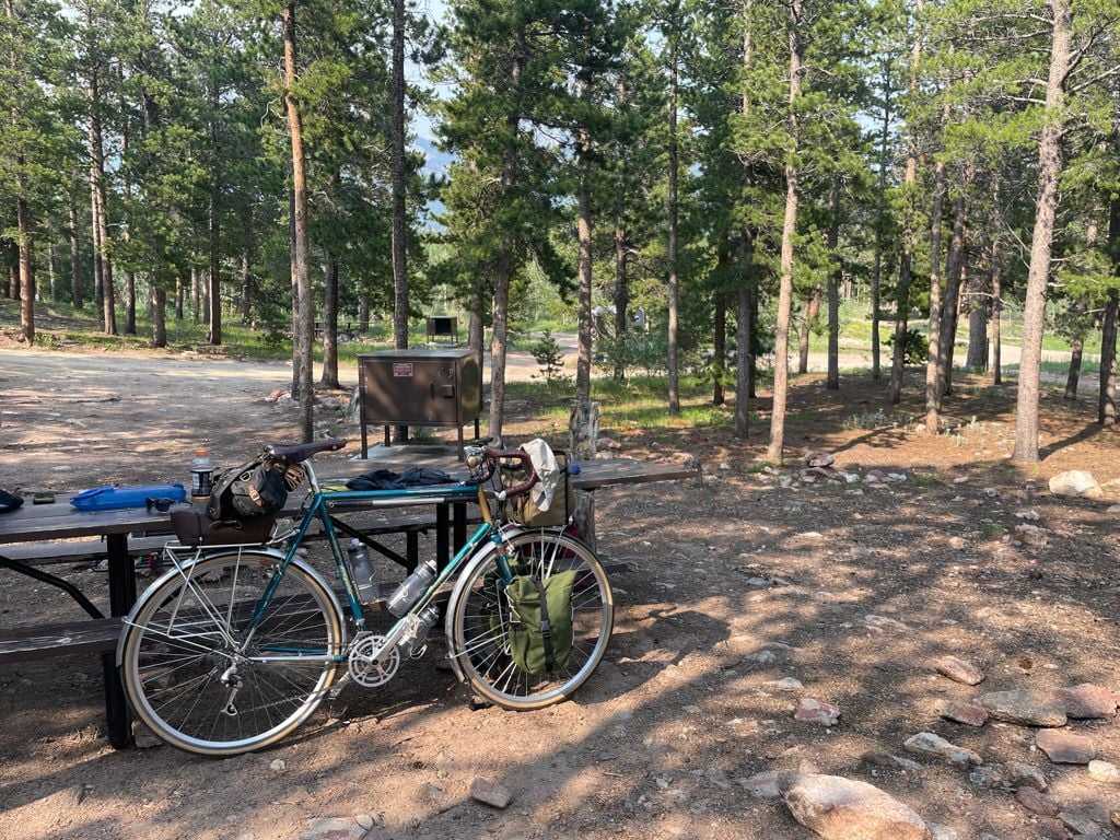
Once again I rode my Koga-Miyata Randonneur Extra. I made a few changes this year, the most consequential being the SON28 dynamo hub, Edelux II headlight, and Sinewave Revolution USB charger. All worked delightfully, though the USB power output required careful management to keep things topped off. With nearly 20,000ft of slow, steep, climbing over 230mi, it wasn�t realistic to expect it to provide for all of our charging needs, but it helped.
I made most of the bags we used, with the exception of my saddlebag. None were new for this tour, but I was experimenting with new attachment mechanism for my front panniers. Since this bike lives in full touring guise now, I left the rear rack on and attached a rack top bag that would house our tent, minus the poles. I wouldn�t call this light touring, but it certainly wasn�t grand touring either. My rando bag was largely empty and used for food, and extra water. A couple nights would be dry, so we carried a 3L water bladder for those occasions.

The Bike
Once again I rode my Koga-Miyata Randonneur Extra. I made a few changes this year, the most consequential being the SON28 dynamo hub, Edelux II headlight, and Sinewave Revolution USB charger. All worked delightfully, though the USB power output required careful management to keep things topped off. With nearly 20,000ft of slow, steep, climbing over 230mi, it wasn�t realistic to expect it to provide for all of our charging needs, but it helped.
I made most of the bags we used, with the exception of my saddlebag. None were new for this tour, but I was experimenting with new attachment mechanism for my front panniers. Since this bike lives in full touring guise now, I left the rear rack on and attached a rack top bag that would house our tent, minus the poles. I wouldn�t call this light touring, but it certainly wasn�t grand touring either. My rando bag was largely empty and used for food, and extra water. A couple nights would be dry, so we carried a 3L water bladder for those occasions.
Last edited by fliplap; 07-23-21 at 09:11 PM.

Likes For fliplap:
07-23-21, 04:58 PM
#2
Full Member
Thread Starter
Day 1 Boulder to Allenspark (38mi, 4300ft)
On my first Colorado mini-tour, I didn’t make much of a plan. This time would be different, mostly because I didn’t ride it alone. My partner refined the route, booked campsites, and drew up a crib sheet of food and water stops.
The ride began with a short jaunt up US36, followed by a climb of scenic St Vrain Canyon. While beautiful, the climb is long, and the day was unseasonably hotter than predicted. We were well into rationing water by the time we reached the top

The first day was short for a couple reasons. We couldn’t reserve a campsite, and the first-come-first-serve campground we knew about often filled up, meaning we’d have to backtrack to an area we knew to be likely to have open dispersed camping. Also, both options would be dry, so we’d need to carry ample water for the night, and the start of the next day.
Fortunately there is a spring a few miles before either option. After the long climb we relished the ice cold, perfectly clear spring water. We filled all of our water bottles, along with the bladder.
We arrived at camp with plenty of time to score a choice spot and relax for awhile before preparing the camp meals we’d brought along for the first night. This would be the only night we’d need to prepare food at camp as our other destinations were close to towns with restaurants and grocery stores.
On my first Colorado mini-tour, I didn’t make much of a plan. This time would be different, mostly because I didn’t ride it alone. My partner refined the route, booked campsites, and drew up a crib sheet of food and water stops.
The ride began with a short jaunt up US36, followed by a climb of scenic St Vrain Canyon. While beautiful, the climb is long, and the day was unseasonably hotter than predicted. We were well into rationing water by the time we reached the top
The first day was short for a couple reasons. We couldn’t reserve a campsite, and the first-come-first-serve campground we knew about often filled up, meaning we’d have to backtrack to an area we knew to be likely to have open dispersed camping. Also, both options would be dry, so we’d need to carry ample water for the night, and the start of the next day.
Fortunately there is a spring a few miles before either option. After the long climb we relished the ice cold, perfectly clear spring water. We filled all of our water bottles, along with the bladder.
We arrived at camp with plenty of time to score a choice spot and relax for awhile before preparing the camp meals we’d brought along for the first night. This would be the only night we’d need to prepare food at camp as our other destinations were close to towns with restaurants and grocery stores.
Likes For fliplap:
07-23-21, 04:59 PM
#3
Full Member
Thread Starter
Day 2 Allenspark to Grand Lake (67mi, 6000ft)
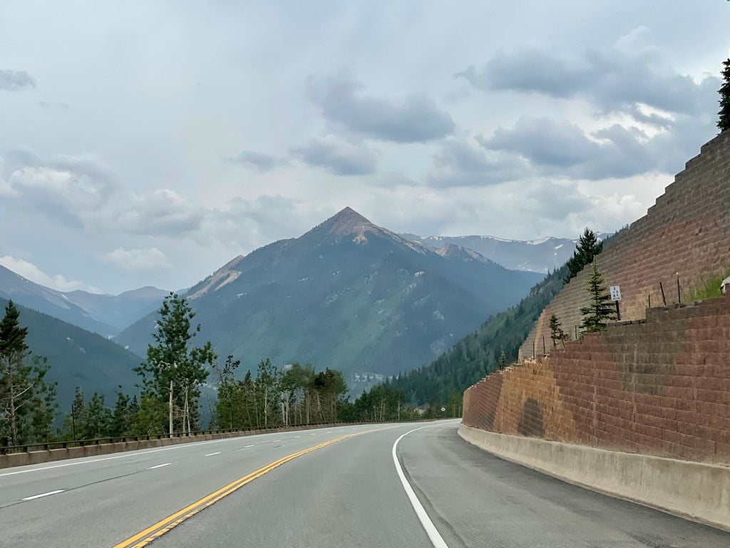
We woke early as we knew today would be both challenging and likely the most beautiful scenery of the trip, so we’d likely stop for pictures often. The day began with a brief climb followed by a long fast descent into Estes Park. We grabbed a packable lunch, and a donut, at the grocery store and continued on our way.
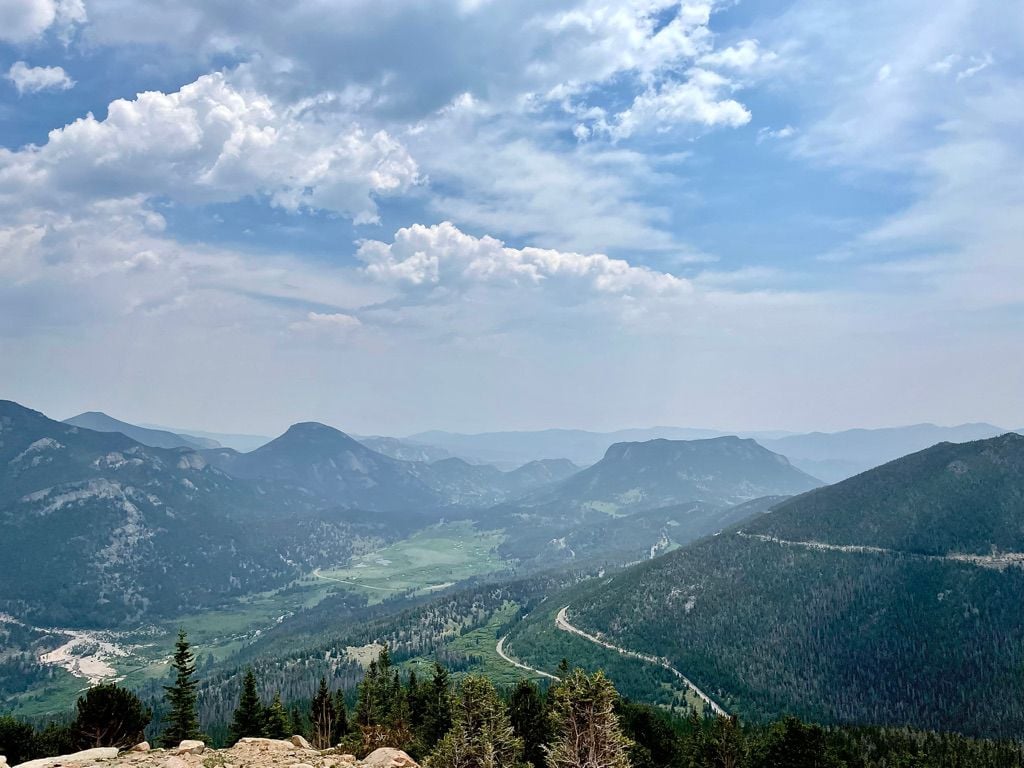
From there we continued to the gate to Rocky Mountains National Park. We paid our $15 each and started the climb along Trail Ridge Road, the highest continuously paved highway in North America, topping out at 12,183ft. Not the highest paved road mind you, that honor goes to Mt Evans which soars to over 14,200ft.

Approaching the tree line at over 2mi above sea level, we looked back on the road we’d climbed, and ahead with much more climbing to go.
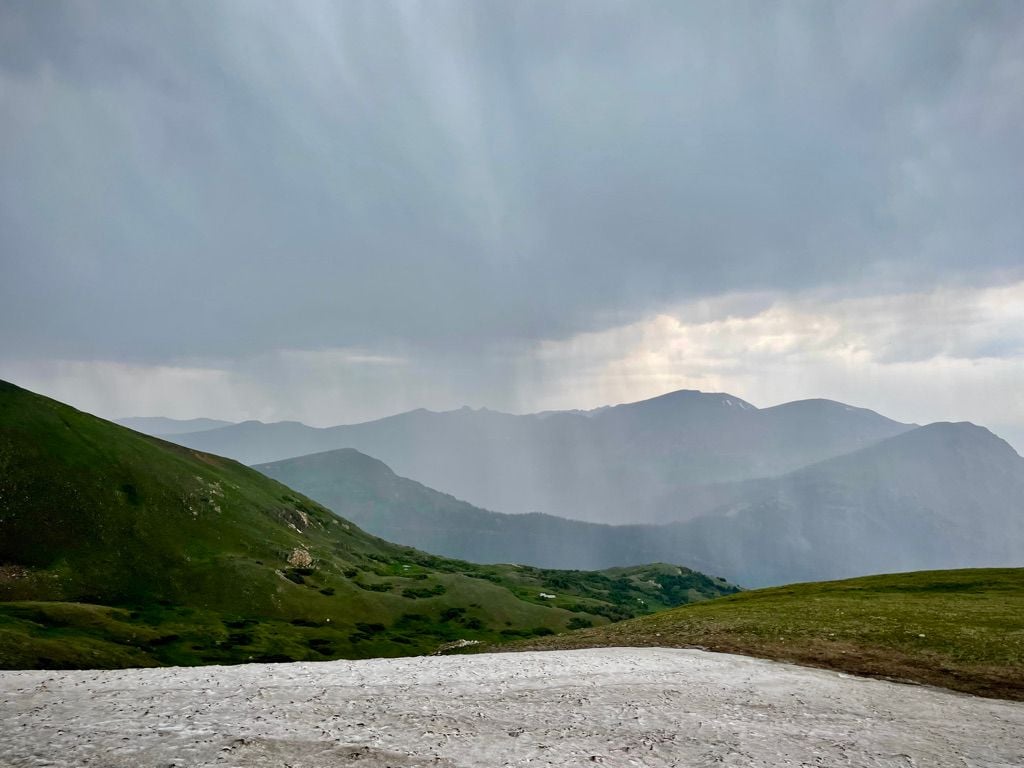
Above 11,500ft we were a world away from the scorching heat of yesterday. Here, the trees gave way to tundra and patches of snow dotted the landscape. Dark clouds and a cold wind chilled the skin, and the soul. A storm was brewing.

The wind carried small droplets that began to accumulate on the map case of my rando bag. We pulled over at 12,000ft to don rain jackets and gloves. Moments later the small droplets turned to stinging rain that quickly froze into hail. I was happy to have the bill of a cycling cap to shield my face from the pellets that stung my legs as we stood and mashed our way past the summit, knowing that the shelter of a visitor’s center was just a couple miles away.
We stashed the bikes near the entrance to a long closed restroom and hustled inside to the warmth of the visitor’s center cafe to wait out the storm. I perused the gift shop, picked through the patches and we departed when the sky cleared. From here we had a long, fast, but damp, descent to Milner Pass, our first crossing of the Continental Divide. For reference, my partner is riding an (off topic) Salsa Vaya Travel.

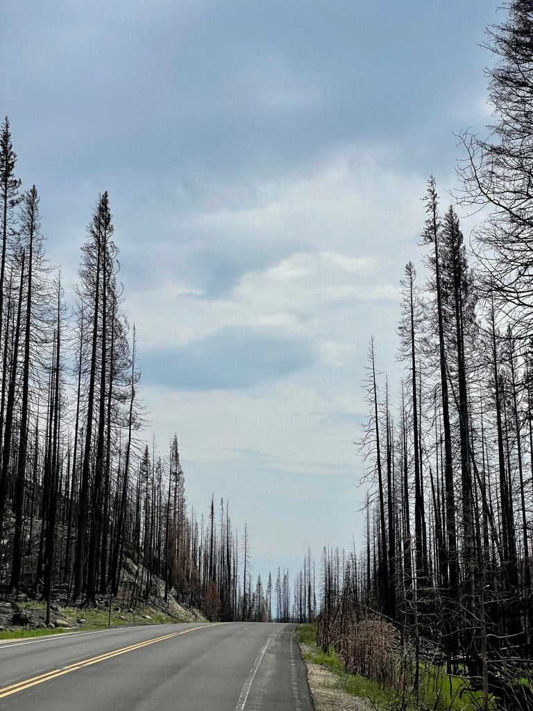
We exited the park at the western edge which burned awhile ago, and provided a sobering contrast to the rest of the park
We stopped for beer and bbq in the town of Grand Lake, before heading to our reserved camp site at the southern edge of Shadow Mountain Lake around sunset

We woke early as we knew today would be both challenging and likely the most beautiful scenery of the trip, so we’d likely stop for pictures often. The day began with a brief climb followed by a long fast descent into Estes Park. We grabbed a packable lunch, and a donut, at the grocery store and continued on our way.
From there we continued to the gate to Rocky Mountains National Park. We paid our $15 each and started the climb along Trail Ridge Road, the highest continuously paved highway in North America, topping out at 12,183ft. Not the highest paved road mind you, that honor goes to Mt Evans which soars to over 14,200ft.
Approaching the tree line at over 2mi above sea level, we looked back on the road we’d climbed, and ahead with much more climbing to go.
Above 11,500ft we were a world away from the scorching heat of yesterday. Here, the trees gave way to tundra and patches of snow dotted the landscape. Dark clouds and a cold wind chilled the skin, and the soul. A storm was brewing.
The wind carried small droplets that began to accumulate on the map case of my rando bag. We pulled over at 12,000ft to don rain jackets and gloves. Moments later the small droplets turned to stinging rain that quickly froze into hail. I was happy to have the bill of a cycling cap to shield my face from the pellets that stung my legs as we stood and mashed our way past the summit, knowing that the shelter of a visitor’s center was just a couple miles away.
We stashed the bikes near the entrance to a long closed restroom and hustled inside to the warmth of the visitor’s center cafe to wait out the storm. I perused the gift shop, picked through the patches and we departed when the sky cleared. From here we had a long, fast, but damp, descent to Milner Pass, our first crossing of the Continental Divide. For reference, my partner is riding an (off topic) Salsa Vaya Travel.
We exited the park at the western edge which burned awhile ago, and provided a sobering contrast to the rest of the park
We stopped for beer and bbq in the town of Grand Lake, before heading to our reserved camp site at the southern edge of Shadow Mountain Lake around sunset
07-23-21, 04:59 PM
#4
Full Member
Thread Starter
Day 3 Grand Lake to Central City (83mi, 6800ft)
Another day of climbing ahead of us, we endeavored to depart early, but ended up sitting by the lake drinking instant coffee and getting out of camp a bit later than expected. Oh well.
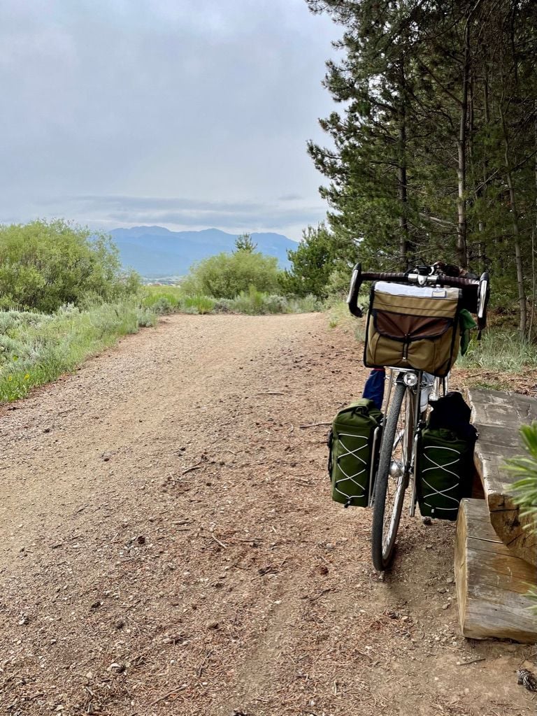
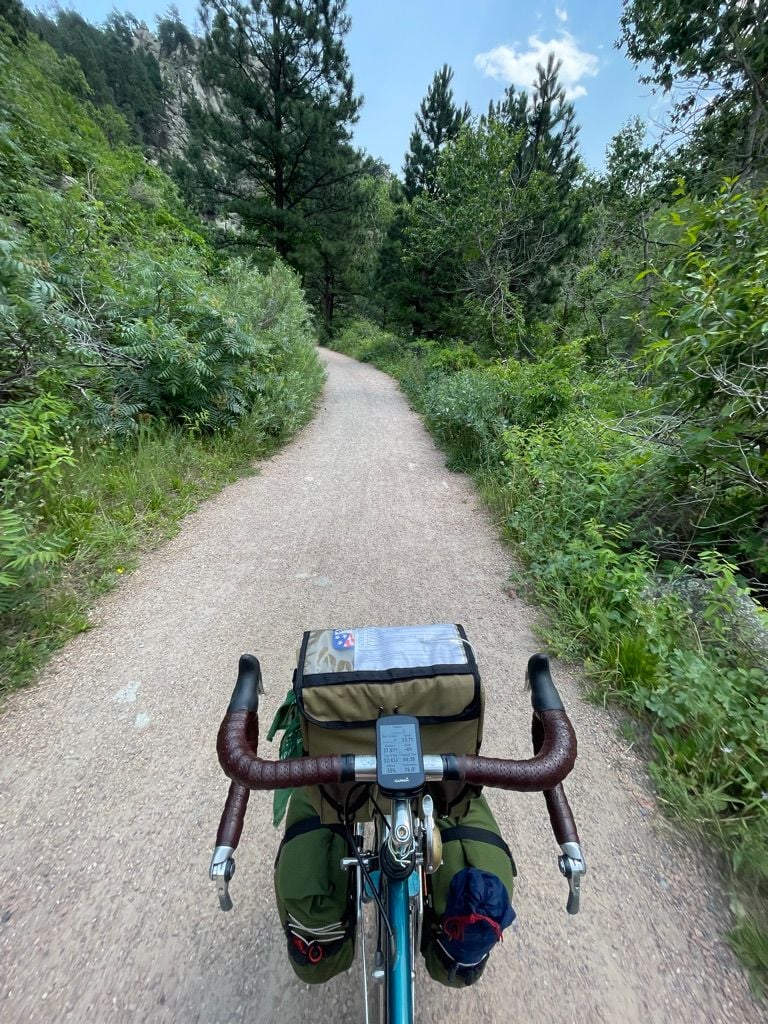
Our first stop of the day would be 13mi on in Granby, CO, and the entry point to the �Fraser to Granby Trail�, a welcome alternative to Highway 40. While they call this a mountain bike trail, and we encountered almost exclusively mountain bikes upon it, it is wide, smooth, and comfortable to ride loaded on 32mm tires.
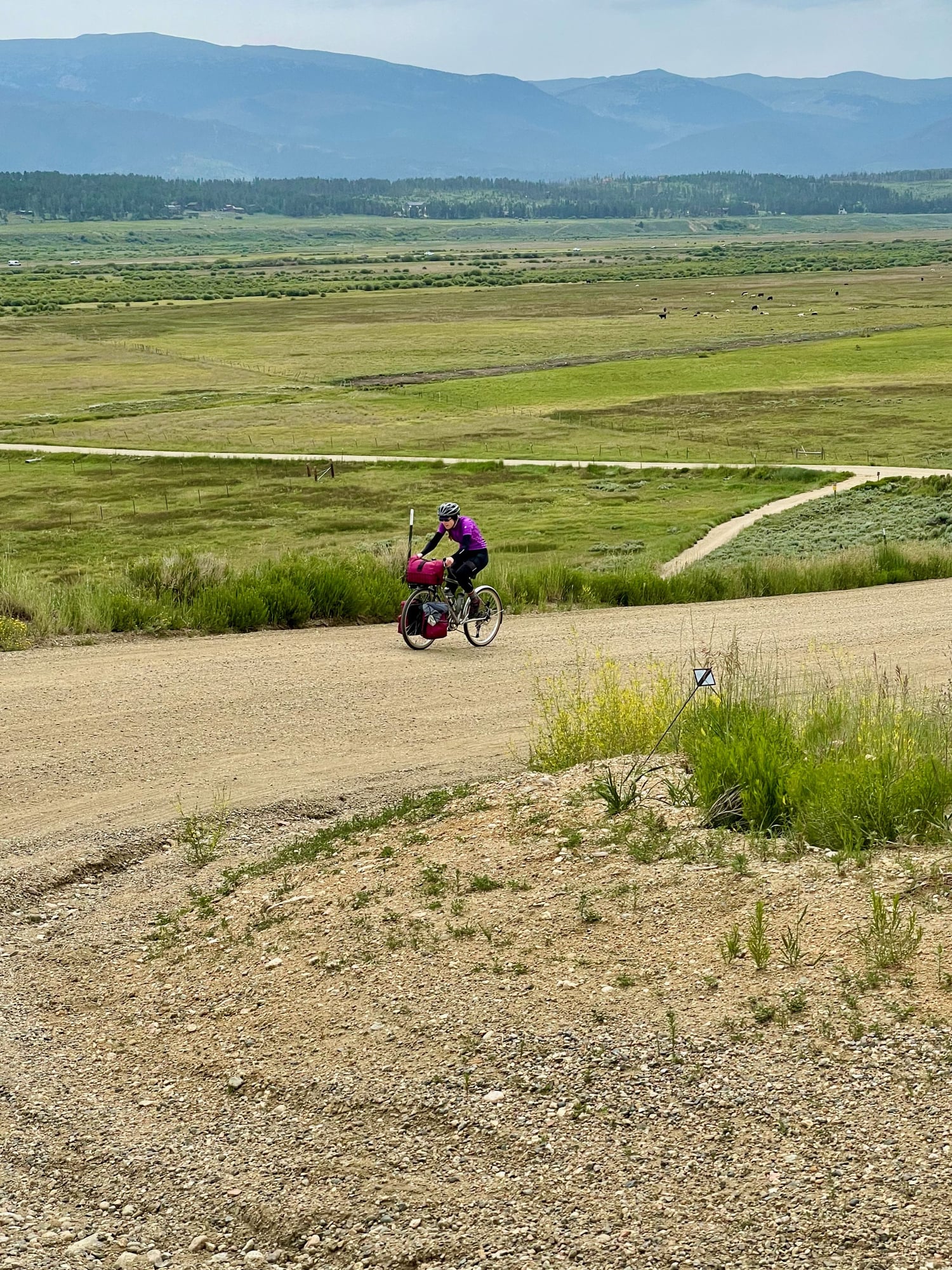
The trail winds through pine trees before exiting to farm land upon a butte overlooking pastures. You can just make out I-40 off in the distance, just beyond the grazing cattle.
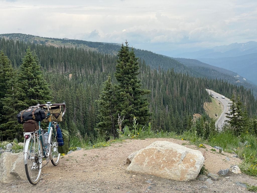
The big climb of the day would take us to our 2nd crossing of the Continental Divide at Berthoud Pass. The first 3 miles of the climb are along the Fraser River Trail, a mostly paved multi-use path that winds through forests and campgrounds along the river to Winter Park. After that, it�s 10mi and 2000ft up to Berthoud Pass. Approximate 4mi from the top we saw the sign: Construction ahead. One lane road. Uh oh. We hoped it wasn�t a single lane flagged section. We hoped we wouldn�t be turned around.
Rounding the mountain, the long line of cars confirmed our fears: A flagger controlled traffic, stopping the flow in one direction while the other passed. We rode to the edge of the closure to get the lowdown from the flag man himself. The friendly gentleman informed us we wouldn�t have a problem. The closure was a mere half mile and a pace truck was keeping cars to 15mph. We�d simply depart after the final car, and they�d keep the road closed while we cleared the controlled section. We hustled and passed the closure not long after the last car.
The closure provided an upside we hadn�t considered: Because traffic was heavier downhill, and the closure was short, the uphill traffic cleared within a few minutes, followed by clearing a long downhill line. This meant that we had 2 minutes of traffic, but for the following 10 minutes we had the road to ourselves, allowing us to take our times, and take photos!

Berthoud Pass makes for the 4th time I�ve crossed the Continental Divide on a tour. The first two being Independence Pass and Tennessee Pass on a previous tour.
The closure also provided wide open roads on the descent where our speed meant that we didn�t see a car going our direction for the next 10 miles
Nearly 3000ft below Berthoud Pass, I-40 would meet I-70 just beyond Empire, CO. After stopping to fill water we had another 1000ft to descend into Idaho Springs, a charming town full of restaurants and bars. By now it was nearly 5pm and we had a couple choices to make: Do we have an early dinner here or find something in Central City? Do we take the shorter, steeper, dirt climb up Virginia Canyon or the longer backtracking route down the I-70 bike route and up Central City Parkway? The decision was made for us by the onset of rain which would make the climb up Virginia Canyon impractical.
Late afternoon rain in the Rockies tends arrive forcefully and pass quickly, so we opted for an early dinner and hoped it would pass. After burgers and burritos we hit the I-70 bike route and met up with Central City Parkway. Camp would be 2000ft up from here, through Central City. The parkway has a wide shoulder and the weekday traffic was light, so we took our time, and chatted as we took in the view.

At the top of the climb we were met with a smooth open road, and a �No Bicycles� sign. Slightly confused we looked at our map which indicated a �Cycleway�. After a moment we identified the 10ft long, overgrown bit of dirt path that connected us to a frontage road that would be our route into town. We learned later that this was a side effect of a 2013 Colorado Supreme Court ruling that upheld that towns could not ban bicycles and must provide adequate access within 450ft of a closed road.
By now the sun was slowly setting and draped the town in a subtle orange glow. The vibe down the main street was about as friendly as the bicycle access. The town is mostly casinos, but the streets were largely deserted, and the few souls present didn�t appear happy to see us. We, on the other hand, were happy we�d chosen to grab dinner in Idaho Springs. We swung into the courtyard of Central City�s opulent Opera House, filled water bottles from a hose bib and hightailed it out of town, towards Columbine Campground.

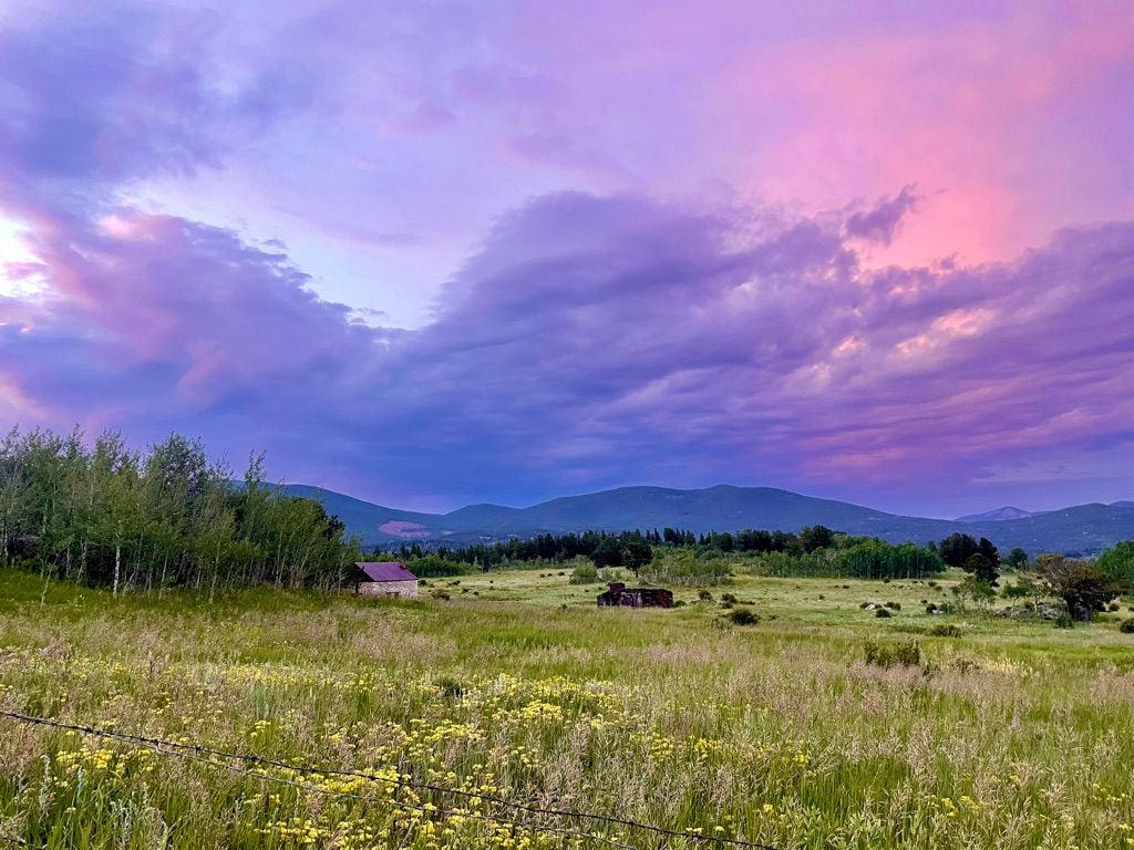
Camp was a bit further on than we'd imagined. We'd plotted our route to the "worst case", and that's exactly what we got. But because of that we were also gifted the sort of sunset for which the Rockies are famous
Another day of climbing ahead of us, we endeavored to depart early, but ended up sitting by the lake drinking instant coffee and getting out of camp a bit later than expected. Oh well.
Our first stop of the day would be 13mi on in Granby, CO, and the entry point to the �Fraser to Granby Trail�, a welcome alternative to Highway 40. While they call this a mountain bike trail, and we encountered almost exclusively mountain bikes upon it, it is wide, smooth, and comfortable to ride loaded on 32mm tires.
The trail winds through pine trees before exiting to farm land upon a butte overlooking pastures. You can just make out I-40 off in the distance, just beyond the grazing cattle.
The big climb of the day would take us to our 2nd crossing of the Continental Divide at Berthoud Pass. The first 3 miles of the climb are along the Fraser River Trail, a mostly paved multi-use path that winds through forests and campgrounds along the river to Winter Park. After that, it�s 10mi and 2000ft up to Berthoud Pass. Approximate 4mi from the top we saw the sign: Construction ahead. One lane road. Uh oh. We hoped it wasn�t a single lane flagged section. We hoped we wouldn�t be turned around.
Rounding the mountain, the long line of cars confirmed our fears: A flagger controlled traffic, stopping the flow in one direction while the other passed. We rode to the edge of the closure to get the lowdown from the flag man himself. The friendly gentleman informed us we wouldn�t have a problem. The closure was a mere half mile and a pace truck was keeping cars to 15mph. We�d simply depart after the final car, and they�d keep the road closed while we cleared the controlled section. We hustled and passed the closure not long after the last car.
The closure provided an upside we hadn�t considered: Because traffic was heavier downhill, and the closure was short, the uphill traffic cleared within a few minutes, followed by clearing a long downhill line. This meant that we had 2 minutes of traffic, but for the following 10 minutes we had the road to ourselves, allowing us to take our times, and take photos!
Berthoud Pass makes for the 4th time I�ve crossed the Continental Divide on a tour. The first two being Independence Pass and Tennessee Pass on a previous tour.
The closure also provided wide open roads on the descent where our speed meant that we didn�t see a car going our direction for the next 10 miles
Nearly 3000ft below Berthoud Pass, I-40 would meet I-70 just beyond Empire, CO. After stopping to fill water we had another 1000ft to descend into Idaho Springs, a charming town full of restaurants and bars. By now it was nearly 5pm and we had a couple choices to make: Do we have an early dinner here or find something in Central City? Do we take the shorter, steeper, dirt climb up Virginia Canyon or the longer backtracking route down the I-70 bike route and up Central City Parkway? The decision was made for us by the onset of rain which would make the climb up Virginia Canyon impractical.
Late afternoon rain in the Rockies tends arrive forcefully and pass quickly, so we opted for an early dinner and hoped it would pass. After burgers and burritos we hit the I-70 bike route and met up with Central City Parkway. Camp would be 2000ft up from here, through Central City. The parkway has a wide shoulder and the weekday traffic was light, so we took our time, and chatted as we took in the view.
At the top of the climb we were met with a smooth open road, and a �No Bicycles� sign. Slightly confused we looked at our map which indicated a �Cycleway�. After a moment we identified the 10ft long, overgrown bit of dirt path that connected us to a frontage road that would be our route into town. We learned later that this was a side effect of a 2013 Colorado Supreme Court ruling that upheld that towns could not ban bicycles and must provide adequate access within 450ft of a closed road.
By now the sun was slowly setting and draped the town in a subtle orange glow. The vibe down the main street was about as friendly as the bicycle access. The town is mostly casinos, but the streets were largely deserted, and the few souls present didn�t appear happy to see us. We, on the other hand, were happy we�d chosen to grab dinner in Idaho Springs. We swung into the courtyard of Central City�s opulent Opera House, filled water bottles from a hose bib and hightailed it out of town, towards Columbine Campground.
Camp was a bit further on than we'd imagined. We'd plotted our route to the "worst case", and that's exactly what we got. But because of that we were also gifted the sort of sunset for which the Rockies are famous
Last edited by fliplap; 07-23-21 at 09:07 PM.
Likes For fliplap:
07-23-21, 05:00 PM
#5
Full Member
Thread Starter
Day 4 Central City to Boulder via Nederland (45mi, 2200ft)
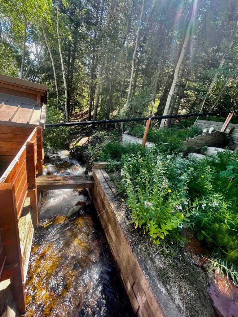
I prefer a mild flavor to the final day of a tour. I enjoy taking my time, drinking camp coffee, taking a long lunch, really savoring the conclusion of the journey. The morning would begin with a smooth fast descent through meadows, past historic cemeteries and along a babbling stream


The dirt road eventually ended at highway 119, which has a reasonable shoulder most of the way and is a roller coaster of short steep climbs and fast descents. We rolled through Rollinsville, and over the train tracks, unforunately too early to stop at any of the plentiful and pleasant looking drinking establishments. We arrived in Nederland just at opening time for the brewery and smokehouse though!

From Nederland it was a fast and familiar cruise down Boulder Canyon, first on the road with it's plentiful shoulder, and then on the smooth gravel bike path, to our finish!
I prefer a mild flavor to the final day of a tour. I enjoy taking my time, drinking camp coffee, taking a long lunch, really savoring the conclusion of the journey. The morning would begin with a smooth fast descent through meadows, past historic cemeteries and along a babbling stream
The dirt road eventually ended at highway 119, which has a reasonable shoulder most of the way and is a roller coaster of short steep climbs and fast descents. We rolled through Rollinsville, and over the train tracks, unforunately too early to stop at any of the plentiful and pleasant looking drinking establishments. We arrived in Nederland just at opening time for the brewery and smokehouse though!
From Nederland it was a fast and familiar cruise down Boulder Canyon, first on the road with it's plentiful shoulder, and then on the smooth gravel bike path, to our finish!
Likes For fliplap:
07-23-21, 08:12 PM
#6
Happy banana slug

Join Date: Sep 2015
Location: Arcata, California, U.S., North America, Earth, Saggitarius Arm, Milky Way
Posts: 3,695
Bikes: 1984 Araya MB 261, 1992 Specialized Rockhopper Sport, 1993 Hard Rock Ultra, 1994 Trek Multitrack 750, 1995 Trek Singletrack 930
Mentioned: 31 Post(s)
Tagged: 0 Thread(s)
Quoted: 1533 Post(s)
Liked 1,528 Times
in
916 Posts
😲 😍
 07-24-21, 06:02 AM
#9

Senior Member
Join Date: Dec 2005
Posts: 17,156
Mentioned: 481 Post(s)
Tagged: 0 Thread(s)
Quoted: 3810 Post(s)
Liked 6,689 Times
in
2,610 Posts
Bravo! Looks like a wonderful tour.
07-24-21, 06:32 AM
#10
Senior Member
Join Date: Aug 2010
Location: Utah
Posts: 8,671
Bikes: Paletti,Pinarello Monviso,Duell Vienna,Giordana XL Super,Lemond Maillot Juane.& custom,PDG Paramount,Fuji Opus III,Davidson Impulse,Pashley Guv'nor,Evans,Fishlips,Y-Foil,Softride, Tetra Pro, CAAD8 Optimo,
Mentioned: 156 Post(s)
Tagged: 0 Thread(s)
Quoted: 2323 Post(s)
Liked 4,988 Times
in
1,776 Posts
Wowser, looks like some wonderful riding!
__________________
Steel is real...and comfy.
Steel is real...and comfy.
